ATL: BERYL - Post-Tropical
Moderator: S2k Moderators
-
Hurricane Andrew

- S2K Supporter

- Posts: 1891
- Age: 27
- Joined: Sun May 23, 2010 2:53 pm
- Location: KS
-
Dean4Storms
- S2K Supporter
- Posts: 6358
- Age: 62
- Joined: Sun Aug 31, 2003 1:01 pm
- Location: Miramar Bch. FL

Re: ATL: INVEST 94L
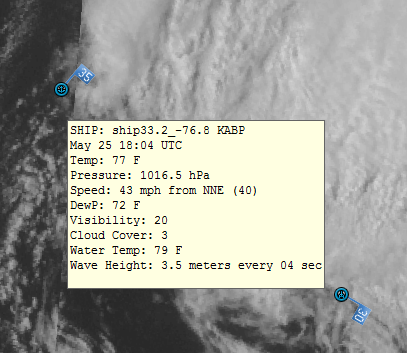
Aric Dunn wrote:pressure falling even faster.... pressure at the buoy ( not the center.) is now 1006mb. winds sustained at near TS force gusting to 50 mph
http://www.ndbc.noaa.gov/plot_wind_pres ... _label=EDT
With such strong winds, I have to come to the conclussion that the pressures of the low pressure center has to be at least 1004 mb if not lower.
By the way, the lowest pressure that the buoy has measured is 1005.7mb
Supplemental Measurements Lowest 1-minute Pressure
Time (EDT) Pressure
3:44 pm 29.70 in
Highest 1-minute Wind Speed
Time (EDT) WSPD WDIR
3:44 pm 36.9 kts SE ( 130 deg true )
0 likes

Re: ATL: INVEST 94L
Looks like it will have some time over the warm gulf stream after the shear lets up and it drifts SW. Hope the models can start to nail down a LLC track.
Given the current proximity the best scenario would be to have it move inland quickly before it has much of a chance to strengthen. Any of the pros using the H word yet?
Given the current proximity the best scenario would be to have it move inland quickly before it has much of a chance to strengthen. Any of the pros using the H word yet?
0 likes
-
SeminoleWind

- Category 1

- Posts: 359
- Age: 51
- Joined: Wed Jun 02, 2010 8:37 pm
- Location: Lake County Florida
Question here, if it were to strengthen faster would that not mean a track further north, say Georgia/SC as opposed to weaker say north Florida?
0 likes
This post is NOT an official forecast and should not be used as such. It is just the opinion of the poster and may or may not be backed by sound meteorological data. It is NOT endorsed by any professional institution including storm2k.org For Official Information please refer to the NHC and NWS products.
-
MGC

- S2K Supporter
- Posts: 5938
- Joined: Sun Mar 23, 2003 9:05 pm
- Location: Pass Christian MS, or what is left.
Re: ATL: INVEST 94L
94L looks like it is coming together quickly this afternoon. Should form SE of NC late Saturday. NHC will wait for recon to verify things. Season is off to a fast start.....MGC
0 likes

Re:
SeminoleWind wrote:Question here, if it were to strengthen faster would that not mean a track further north, say Georgia/SC as opposed to weaker say north Florida?
models has trended south and west in the next 72hrs....I think they are getting a handle on the strength of the ridge...
0 likes
-
SunnyThoughts
- Category 5

- Posts: 2263
- Joined: Wed Jul 09, 2003 12:42 pm
- Location: Pensacola, Florida
Re: ATL: INVEST 94L
Nimbus wrote:Looks like it will have some time over the warm gulf stream after the shear lets up and it drifts SW. Hope the models can start to nail down a LLC track.
Given the current proximity the best scenario would be to have it move inland quickly before it has much of a chance to strengthen. Any of the pros using the H word yet?
Haven't heard anyone use the "H" word yet. Although, if the storm strengthens sooner than expected, which everyone seems to think it might be doing, There isn't that much difference between a moderate to strong tropical storm..and that "H" word.
0 likes
-
Evil Jeremy

- S2K Supporter
- Posts: 5463
- Age: 32
- Joined: Mon Apr 10, 2006 2:10 pm
- Location: Los Angeles, CA
Re: Re:
ROCK wrote:SeminoleWind wrote:Question here, if it were to strengthen faster would that not mean a track further north, say Georgia/SC as opposed to weaker say north Florida?
models has trended south and west in the next 72hrs....I think they are getting a handle on the strength of the ridge...
And a strong storm and a strong ridge would only reinforce each other. A reciprocal interaction that results in 94L being pushed more south.
0 likes
Frances 04 / Jeanne 04 / Katrina 05 / Wilma 05 / Fay 08 / Debby 12 / Andrea 13 / Colin 16 / Hermine 16 / Matthew 16 / Irma 17
-
SunnyThoughts
- Category 5
- Posts: 2263
- Joined: Wed Jul 09, 2003 12:42 pm
- Location: Pensacola, Florida
-
northjaxpro

- S2K Supporter
- Posts: 8900
- Joined: Mon Sep 27, 2010 11:21 am
- Location: Jacksonville, FL
94L is slowly beginning to put some clothes on now. Satellite visible imagery presentation shows that the organization is gradually improving . I agree that later tonight as the shear relaxes even more we will begin to see convection fire around the circulation center and begin wrapping into it as well. I would not be surprised if NHC names it a TS by tomorrow morning. Recon is scheduled for 18Z tomorrow afternoon, but I have a feeling it will be designated by that time.
0 likes
NEVER, EVER SAY NEVER in the tropics and weather in general, and most importantly, with life itself!!
________________________________________________________________________________________
Fay 2008 Beryl 2012 Debby 2012 Colin 2016 Hermine 2016 Julia 2016 Matthew 2016 Irma 2017 Dorian 2019
________________________________________________________________________________________
Fay 2008 Beryl 2012 Debby 2012 Colin 2016 Hermine 2016 Julia 2016 Matthew 2016 Irma 2017 Dorian 2019
-
Aric Dunn
- Category 5
- Posts: 21238
- Age: 43
- Joined: Sun Sep 19, 2004 9:58 pm
- Location: Ready for the Chase.
- Contact:
Re:
NDG wrote:IMO, along with satellite presentation, buoy reports will be enough to upgrade 94L later tonight or tomorrow morning before recon gets there tomorrow afternoon.
well its probably close to being sub tropical atm but still a little to frontal.
0 likes
Note: If I make a post that is brief. Please refer back to previous posts for the analysis or reasoning. I do not re-write/qoute what my initial post said each time.
If there is nothing before... then just ask
Space & Atmospheric Physicist, Embry-Riddle Aeronautical University,
I believe the sky is falling...
If there is nothing before... then just ask
Space & Atmospheric Physicist, Embry-Riddle Aeronautical University,
I believe the sky is falling...
Re: Re:
Aric Dunn wrote:NDG wrote:IMO, along with satellite presentation, buoy reports will be enough to upgrade 94L later tonight or tomorrow morning before recon gets there tomorrow afternoon.
well its probably close to being sub tropical atm but still a little to frontal.
True, it has that frontal look.
0 likes

-
thundercam96

- Tropical Storm

- Posts: 129
- Joined: Thu Aug 18, 2011 3:01 pm
- Location: Boston, MA
The models keep moving south through florida
0 likes
Fay '08 / Mathew 16'
Personal Forecast Disclaimer: I am not a certified meteorologist, therefore, what is posted on this forum under my header should not be treated as an official forecast. Please refer to the NWS/NHC products for forecast information.
Personal Forecast Disclaimer: I am not a certified meteorologist, therefore, what is posted on this forum under my header should not be treated as an official forecast. Please refer to the NWS/NHC products for forecast information.
-
northjaxpro
- S2K Supporter
- Posts: 8900
- Joined: Mon Sep 27, 2010 11:21 am
- Location: Jacksonville, FL
The apparent circulation based on visible satellite is at 31.5 N 74.9 W.
Rough estimate of course.
Rough estimate of course.
0 likes
NEVER, EVER SAY NEVER in the tropics and weather in general, and most importantly, with life itself!!
________________________________________________________________________________________
Fay 2008 Beryl 2012 Debby 2012 Colin 2016 Hermine 2016 Julia 2016 Matthew 2016 Irma 2017 Dorian 2019
________________________________________________________________________________________
Fay 2008 Beryl 2012 Debby 2012 Colin 2016 Hermine 2016 Julia 2016 Matthew 2016 Irma 2017 Dorian 2019
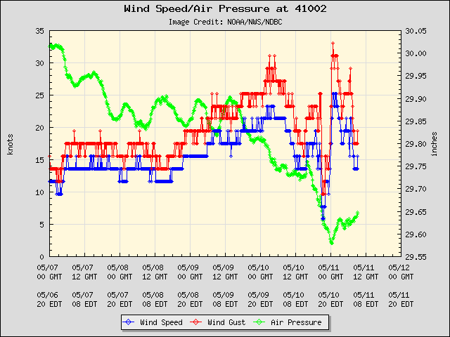
Buoy's pressure now down to 1004 mb!!
Conditions at 41002 as of
(4:50 pm EDT)
2050 GMT on 05/25/2012:
Wind Direction (WDIR): SE ( 140 deg true )
Wind Speed (WSPD): 23.3 kts
Wind Gust (GST): 29.1 kts
Wave Height (WVHT): 15.1 ft
Dominant Wave Period (DPD): 10 sec
Average Period (APD): 7.1 sec
Mean Wave Direction (MWD): SSE ( 158 deg true )
Atmospheric Pressure (PRES): 29.66 in
Pressure Tendency (PTDY): -0.24 in ( Falling Rapidly )
Air Temperature (ATMP): 76.3 °F
Water Temperature (WTMP): 78.1 °F
Dew Point (DEWP): 75.0 °F
Combined plot of Wind Speed, Gust, and Air Pressure
0 likes
-
Aric Dunn
- Category 5
- Posts: 21238
- Age: 43
- Joined: Sun Sep 19, 2004 9:58 pm
- Location: Ready for the Chase.
- Contact:
Re: ATL: INVEST 94L
pressure at buoy now down to 1004Mb
center should be very near bye. winds direction switched to SE.
center should be very near bye. winds direction switched to SE.
0 likes
Note: If I make a post that is brief. Please refer back to previous posts for the analysis or reasoning. I do not re-write/qoute what my initial post said each time.
If there is nothing before... then just ask
Space & Atmospheric Physicist, Embry-Riddle Aeronautical University,
I believe the sky is falling...
If there is nothing before... then just ask
Space & Atmospheric Physicist, Embry-Riddle Aeronautical University,
I believe the sky is falling...
Who is online
Users browsing this forum: No registered users and 21 guests