ATL: BERYL - Post-Tropical
Moderator: S2k Moderators

Re: ATL: INVEST 94L
we could really use a good 3-5 inch rain here in Central Florida...but don't need the winds though...
0 likes
Just like Jon Snow..."I know nothing" except what I know, and most of what I know is gathered by the fine people of the NHC
-
ozonepete
- Professional-Met

- Posts: 4743
- Joined: Mon Sep 07, 2009 3:23 pm
- Location: From Ozone Park, NYC / Now in Brooklyn, NY
Re: ATL: INVEST 94L
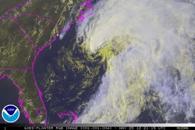
LLC has expanded and is moving northwest now. Still plenty of shear but convection firing near center is definitely vigorous. As soon as it starts moving SW it will move into lower shear.
0 likes
-
TropicalAnalystwx13

- Category 5

- Posts: 2109
- Age: 28
- Joined: Tue Jul 19, 2011 8:20 pm
- Location: Wilmington, NC
- Contact:

-
Evil Jeremy

- S2K Supporter

- Posts: 5463
- Age: 32
- Joined: Mon Apr 10, 2006 2:10 pm
- Location: Los Angeles, CA
Re: ATL: INVEST 94L
ozonepete wrote:LLC has expanded and is moving northwest now. Still plenty of shear but convection firing near center is definitely vigorous. As soon as it starts moving SW it will move into lower shear.
http://i189.photobucket.com/albums/z174 ... rgb0-1.jpg
IMO, that is well defined enough to be classified. The LLC is clearly organized and the winds are strong with this one.
0 likes
Frances 04 / Jeanne 04 / Katrina 05 / Wilma 05 / Fay 08 / Debby 12 / Andrea 13 / Colin 16 / Hermine 16 / Matthew 16 / Irma 17
-
Hurricane Andrew

- S2K Supporter
- Posts: 1891
- Age: 27
- Joined: Sun May 23, 2010 2:53 pm
- Location: KS
-
TropicalAnalystwx13
- Category 5
- Posts: 2109
- Age: 28
- Joined: Tue Jul 19, 2011 8:20 pm
- Location: Wilmington, NC
- Contact:


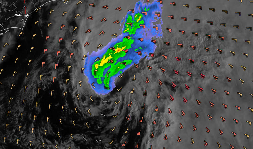
Apparent LLC looks to be passing just to the west of buoy 41002 as it looks to be moving now to the NNW
Conditions at 41002 as of
(5:50 pm EDT)
2150 GMT on 05/25/2012:
Wind Direction (WDIR): S ( 190 deg true )
Wind Speed (WSPD): 29.1 kts
Wind Gust (GST): 36.9 kts
Wave Height (WVHT): 13.8 ft
Dominant Wave Period (DPD): 10 sec
Average Period (APD): 6.8 sec
Mean Wave Direction (MWD): SE ( 140 deg true )
Atmospheric Pressure (PRES): 29.67 in
Pressure Tendency (PTDY): -0.12 in ( Falling Rapidly )
Air Temperature (ATMP): 76.5 °F
Water Temperature (WTMP): 78.1 °F
Dew Point (DEWP): 74.3 °F
0 likes
-
Kingarabian

- S2K Supporter
- Posts: 16348
- Joined: Sat Aug 08, 2009 3:06 am
- Location: Honolulu, Hawaii
-
ozonepete
- Professional-Met
- Posts: 4743
- Joined: Mon Sep 07, 2009 3:23 pm
- Location: From Ozone Park, NYC / Now in Brooklyn, NY
Re: Re:
TropicalAnalystwx13 wrote:Hurricane Andrew wrote:What's the core temp?
It's a shallow warm-core, so subtropical.
Tolakram and GCANE usually look it up. If you wanted the exact number it's on the FSU site.
BTW be careful. If it's warm core it is NOT subtropical, it's tropical. It has to be cold core or transitioning from cold core to warm core to be subtropical (along with other factors.)
0 likes
-
Evil Jeremy
- S2K Supporter
- Posts: 5463
- Age: 32
- Joined: Mon Apr 10, 2006 2:10 pm
- Location: Los Angeles, CA
I have some folks a little North of Jacksonville who have no idea what could threaten them. I've been talking to them all day, and they think nothing big is going to happen. They're the kind of people who go only by what the Weather Channel says, and TWC can only give vague statements until the NHC gives them official data.
0 likes
Frances 04 / Jeanne 04 / Katrina 05 / Wilma 05 / Fay 08 / Debby 12 / Andrea 13 / Colin 16 / Hermine 16 / Matthew 16 / Irma 17
-
Aric Dunn
- Category 5
- Posts: 21238
- Age: 43
- Joined: Sun Sep 19, 2004 9:58 pm
- Location: Ready for the Chase.
- Contact:
its definitely moving very slowly nw. started its turn.
0 likes
Note: If I make a post that is brief. Please refer back to previous posts for the analysis or reasoning. I do not re-write/qoute what my initial post said each time.
If there is nothing before... then just ask
Space & Atmospheric Physicist, Embry-Riddle Aeronautical University,
I believe the sky is falling...
If there is nothing before... then just ask
Space & Atmospheric Physicist, Embry-Riddle Aeronautical University,
I believe the sky is falling...
-
Mouton
- S2K Supporter
- Posts: 222
- Age: 80
- Joined: Sat Jul 30, 2011 8:13 am
- Location: Amelia Island Florida
I live a tad north of Jax on Amelia Island. The local weather reports on the news have been very informative of the potential if your friends are paying attention.
As fa as 94L goes, I am not convinced this is going to be a major problem due to the heavy shear and amount of dry air around the budding system. Granting the SST are running close to 80 here now.
Regardless of being a holiday weekend, we really could use a good dousing of rain here and I hope I am wrong.
Vince
0 likes
-
cycloneye

- Admin

- Posts: 149278
- Age: 69
- Joined: Thu Oct 10, 2002 10:54 am
- Location: San Juan, Puerto Rico
Re: ATL: INVEST 94L
Being a long holiday weekend,this message will very important.
COASTAL HAZARD MESSAGE
NATIONAL WEATHER SERVICE NEWPORT/MOREHEAD CITY NC
412 PM EDT FRI MAY 25 2012
...HIGH THREAT OF RIP CURRENTS SATURDAY ALONG ALL BEACHES...
.SOUTHEAST SWELL FROM LOW PRESSURE SYSTEM OFF THE COAST OF THE
CAROLINAS IS FORECAST TO IMPACT NORTH CAROLINA COAST.
NCZ095-098-103-104-260415-
/O.NEW.KMHX.BH.S.0004.120526T1200Z-120527T0000Z/
CARTERET-ONSLOW-OUTER BANKS DARE-OUTER BANKS HYDE-
412 PM EDT FRI MAY 25 2012
...BEACH HAZARDS STATEMENT IN EFFECT FROM SATURDAY MORNING
THROUGH SATURDAY EVENING...
THE NATIONAL WEATHER SERVICE IN NEWPORT/MOREHEAD CITY HAS ISSUED
A BEACH HAZARDS STATEMENT...WHICH IS IN EFFECT FROM SATURDAY
MORNING THROUGH SATURDAY EVENING.
* HAZARDS...HIGH RIP CURRENT RISK AND DANGEROUS SHORE BREAK.
* LOCATION...ALONG THE BEACHES.
* TIMING AND TIDES...THE MOST LIKELY TIME FOR LIFE THREATENING RIP
CURRENTS WILL BE A COUPLE OF HOURS EITHER SIDE OF LOW TIDE. LOW
TIDE WILL OCCUR AROUND 530 PM SATURDAY.
* POTENTIAL IMPACTS...DANGEROUS RIP CURRENTS COMBINED WITH ROUGH
SURF OF 4 TO 6 FEET.
PRECAUTIONARY/PREPAREDNESS ACTIONS...
RIP CURRENTS ARE POWERFUL CHANNELS OF WATER FLOWING QUICKLY AWAY
FROM SHORE...WHICH OCCUR MOST OFTEN AT LOW SPOTS OR BREAKS IN THE
SANDBAR AND IN THE VICINITY OF STRUCTURES SUCH AS GROINS...JETTIES
AND PIERS. HEED THE ADVICE OF LIFEGUARDS AND THE BEACH PATROL. PAY
ATTENTION TO FLAGS AND POSTED SIGNS POSTED NEAR BEACH ACCESS
POINTS AND LIFEGUARD STATIONS.
IF YOU BECOME CAUGHT IN A RIP CURRENT...DO NOT PANIC. REMAIN CALM
AND BEGIN TO SWIM PARALLEL TO SHORE. ONCE YOU ARE AWAY FROM THE
FORCE OF THE RIP CURRENT...BEGIN TO SWIM BACK TO THE BEACH. DO NOT
ATTEMPT TO SWIM DIRECTLY AGAINST A RIP CURRENT...SINCE IT CAN
EXHAUST AND EVEN KILL THE STRONGEST SWIMMER.
SHORE BREAK OCCURS WHEN WAVES BREAK DIRECTLY ON THE BEACH. THE
MOST COMMON INJURIES WITH STRONG SHORE BREAK ARE NECK AND BACK
INJURIES...WHICH MOST OFTEN OCCUR WHEN THE POWERFUL SURF THROWS A
SWIMMER OR SURFER HEAD FIRST INTO THE BOTTOM. IT IS EXTREMELY
IMPORTANT TO PROTECT YOUR HEAD AND NECK WHENEVER YOU ARE IN
BREAKING WAVES BY KEEPING YOUR HANDS IN FRONT OF YOU AT ALL TIMES.
PLEASE VISIT THE FOLLOWING WEBSITE TO SHARE YOUR THOUGHTS ON THE
NEW BEACH HAZARDS STATEMENT...
HTTP://WWW.WEATHER.GOV/SURVEY/NWS-SURVEY.PHP?CODE =CHMBHS
&&
$$
0 likes
Visit the Caribbean-Central America Weather Thread where you can find at first post web cams,radars
and observations from Caribbean basin members Click Here
and observations from Caribbean basin members Click Here
-
northjaxpro

- S2K Supporter
- Posts: 8900
- Joined: Mon Sep 27, 2010 11:21 am
- Location: Jacksonville, FL
Re:
Evil Jeremy wrote:I have some folks a little North of Jacksonville who have no idea what could threaten them. I've been talking to them all day, and they think nothing big is going to happen. They're the kind of people who go only by what the Weather Channel says, and TWC can only give vague statements until the NHC gives them official data.
That is always a big worry as complacency is always a potential hindrence with situations like this. It has been since 1964 since Northeast Florida has had a direct landfall from a strong tropical cyclone from the east. I have been advising people I know and businesses out at the Jacksonville Beach and Fernandina Beach of potentially what may be coming within the next 72 hours.
However, the word is beginning to get out now. WJXT TV-4 here in Jax lead the newscast with breaking story of the pending development of Beryl. So, hopefully people in this area will prepare and be watc hful over the holiday weekend. Beryl could pull a surprise or two unexpectedly and of course people need to be ready.
It is hopefully a situation where we get rain to end the drought. That is really all I hope will happen and nothing worse for sure.
Last edited by northjaxpro on Fri May 25, 2012 5:37 pm, edited 1 time in total.
0 likes
NEVER, EVER SAY NEVER in the tropics and weather in general, and most importantly, with life itself!!
________________________________________________________________________________________
Fay 2008 Beryl 2012 Debby 2012 Colin 2016 Hermine 2016 Julia 2016 Matthew 2016 Irma 2017 Dorian 2019
________________________________________________________________________________________
Fay 2008 Beryl 2012 Debby 2012 Colin 2016 Hermine 2016 Julia 2016 Matthew 2016 Irma 2017 Dorian 2019
-
cycloneye
- Admin
- Posts: 149278
- Age: 69
- Joined: Thu Oct 10, 2002 10:54 am
- Location: San Juan, Puerto Rico
Re: ATL: INVEST 94L
"Impressive" is the word I express for this.
0 likes
Visit the Caribbean-Central America Weather Thread where you can find at first post web cams,radars
and observations from Caribbean basin members Click Here
and observations from Caribbean basin members Click Here
-
cycloneye
- Admin
- Posts: 149278
- Age: 69
- Joined: Thu Oct 10, 2002 10:54 am
- Location: San Juan, Puerto Rico
Re: ATL: INVEST 94L
The following post is NOT an official forecast and should not be used as such. It is just the opinion of the poster and may or may not be backed by sound meteorological data. It is NOT endorsed by any professional institution including storm2k.org. For Official Information please refer to the NHC and NWS products.
Tweet from Joe Bastardi.
@BigJoeBastardi loss of visible imagery may preclude NHC naming until tomorrow morning -- from IR, I'd go for Subtropical Depression
http://twitter.com/BigJoeBastardi/statu ... 33/photo/1
Tweet from Joe Bastardi.
@BigJoeBastardi loss of visible imagery may preclude NHC naming until tomorrow morning -- from IR, I'd go for Subtropical Depression
http://twitter.com/BigJoeBastardi/statu ... 33/photo/1
0 likes
Visit the Caribbean-Central America Weather Thread where you can find at first post web cams,radars
and observations from Caribbean basin members Click Here
and observations from Caribbean basin members Click Here
-
ozonepete
- Professional-Met
- Posts: 4743
- Joined: Mon Sep 07, 2009 3:23 pm
- Location: From Ozone Park, NYC / Now in Brooklyn, NY
Re: ATL: INVEST 94L
You can definitely see it's starting the U-turn (as Aric also said) from the recent visible and RGB satellite loops. Looks like it's going to be a fairly tight turn too.
0 likes
-
SeminoleWind

- Category 1

- Posts: 359
- Age: 51
- Joined: Wed Jun 02, 2010 8:37 pm
- Location: Lake County Florida
Yep looks like it is trying to do a little whip around, zoom it in and speed it up
http://www.ssd.noaa.gov/PS/TROP/floater ... short.html
http://www.ssd.noaa.gov/PS/TROP/floater ... short.html
0 likes
This post is NOT an official forecast and should not be used as such. It is just the opinion of the poster and may or may not be backed by sound meteorological data. It is NOT endorsed by any professional institution including storm2k.org For Official Information please refer to the NHC and NWS products.
-
thundercam96

- Tropical Storm

- Posts: 129
- Joined: Thu Aug 18, 2011 3:01 pm
- Location: Boston, MA
Is this still a probable GA landfall, or is Florida still in the runs for a potential landfall?
0 likes
Fay '08 / Mathew 16'
Personal Forecast Disclaimer: I am not a certified meteorologist, therefore, what is posted on this forum under my header should not be treated as an official forecast. Please refer to the NWS/NHC products for forecast information.
Personal Forecast Disclaimer: I am not a certified meteorologist, therefore, what is posted on this forum under my header should not be treated as an official forecast. Please refer to the NWS/NHC products for forecast information.
Who is online
Users browsing this forum: No registered users and 89 guests