ATL: BERYL - Post-Tropical

Moderator: S2k Moderators

Message
Author
User avatar
Evil Jeremy
S2K Supporter
S2K Supporter
Posts: 5463
Age: 32
Joined: Mon Apr 10, 2006 2:10 pm
Location: Los Angeles, CA

Re: ATL: INVEST 94L

#421 Postby Evil Jeremy » Fri May 25, 2012 5:51 pm

cycloneye wrote:The following post is NOT an official forecast and should not be used as such. It is just the opinion of the poster and may or may not be backed by sound meteorological data. It is NOT endorsed by any professional institution including storm2k.org. For Official Information please refer to the NHC and NWS products.


Twitter from Joe Bastardi.

@BigJoeBastardi loss of visible imagery may preclude NHC naming until tomorrow morning -- from IR, I'd go for Subtropical Depression


I thought this would happen. NHC loves having satellite images when upgrading a storm. We probably won't get an upgrade until 11am. I'm still pulling for a classification tonight though.
0 likes   
Frances 04 / Jeanne 04 / Katrina 05 / Wilma 05 / Fay 08 / Debby 12 / Andrea 13 / Colin 16 / Hermine 16 / Matthew 16 / Irma 17

Dean4Storms
S2K Supporter
S2K Supporter
Posts: 6358
Age: 62
Joined: Sun Aug 31, 2003 1:01 pm
Location: Miramar Bch. FL

Re: ATL: INVEST 94L

#422 Postby Dean4Storms » Fri May 25, 2012 5:55 pm

cycloneye wrote:The following post is NOT an official forecast and should not be used as such. It is just the opinion of the poster and may or may not be backed by sound meteorological data. It is NOT endorsed by any professional institution including storm2k.org. For Official Information please refer to the NHC and NWS products.


Tweet from Joe Bastardi.

@BigJoeBastardi loss of visible imagery may preclude NHC naming until tomorrow morning -- from IR, I'd go for Subtropical Depression

http://twitter.com/BigJoeBastardi/statu ... 33/photo/1


Actually that is @Joe from RyanMaue...... Joe is saying it is a Tropical Storm already!

BigJoeBastardi

THIS IS NOW A TROPICAL STORM http://pic.twitter.com/0ssZRPTL
0 likes   

Dean4Storms
S2K Supporter
S2K Supporter
Posts: 6358
Age: 62
Joined: Sun Aug 31, 2003 1:01 pm
Location: Miramar Bch. FL

#423 Postby Dean4Storms » Fri May 25, 2012 5:56 pm

It's the most organized disturbance I've seen in a long time without being classified something!
0 likes   

ozonepete
Professional-Met
Professional-Met
Posts: 4743
Joined: Mon Sep 07, 2009 3:23 pm
Location: From Ozone Park, NYC / Now in Brooklyn, NY

Re:

#424 Postby ozonepete » Fri May 25, 2012 5:58 pm

thundercam96 wrote:Is this still a probable GA landfall, or is Florida still in the runs for a potential landfall?


It's probably going to be close enough to the border that northern Florida and southern Georgia will both get some pretty good effects. The northern side of the storm will get the heaviest rain at first so one would think southern Georgia should get a real soaking even if the center moves in over northern Florida. But remember that it is forecast to slow down, and if it does, the rain shield will expand in all directions so all of those areas could get flooding.

The posts in this forum are NOT official forecast and should not be used as such. They are just the opinion of the poster and may or may not be backed by sound meteorological data. They are NOT endorsed by any professional institution or storm2k.org. For official information, please refer to the NHC and NWS products.
0 likes   

ozonepete
Professional-Met
Professional-Met
Posts: 4743
Joined: Mon Sep 07, 2009 3:23 pm
Location: From Ozone Park, NYC / Now in Brooklyn, NY

Re: ATL: INVEST 94L

#425 Postby ozonepete » Fri May 25, 2012 6:02 pm

:uarrow: BTW the models have been trending further south so I personally think this is going into northern Florida. Especially because it's turning southward earlier than forecast. Just IMHO.

The posts in this forum are NOT official forecast and should not be used as such. They are just the opinion of the poster and may or may not be backed by sound meteorological data. They are NOT endorsed by any professional institution or storm2k.org. For official information, please refer to the NHC and NWS products.
0 likes   

User avatar
thundercam96
Tropical Storm
Tropical Storm
Posts: 129
Joined: Thu Aug 18, 2011 3:01 pm
Location: Boston, MA

#426 Postby thundercam96 » Fri May 25, 2012 6:05 pm

@bigjoebastardi Was saying its a tropical storm..... Thats An Opinion....Right?
0 likes   
Fay '08 / Mathew 16'

Personal Forecast Disclaimer: I am not a certified meteorologist, therefore, what is posted on this forum under my header should not be treated as an official forecast. Please refer to the NWS/NHC products for forecast information.

User avatar
NDG
S2K Supporter
S2K Supporter
Posts: 15446
Joined: Sun Jul 09, 2006 10:14 pm
Location: Orlando, FL

#427 Postby NDG » Fri May 25, 2012 6:06 pm

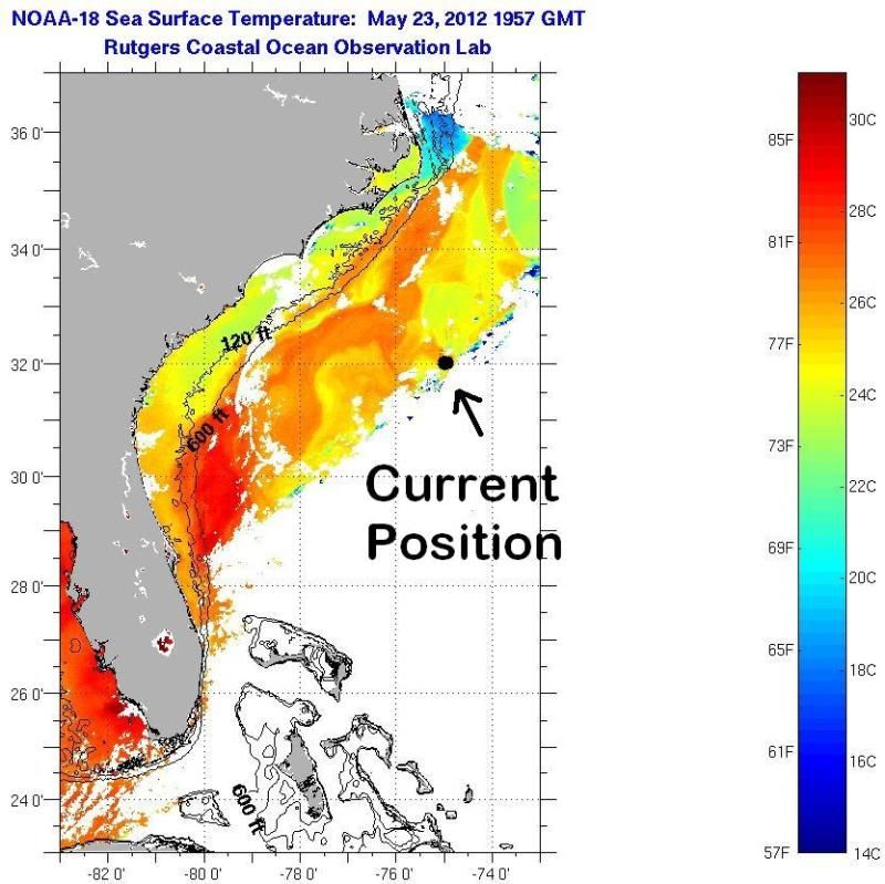
Current postion of 94L, warmer waters of the gulf stream is just to its north & west, should be tracking over it later tonight, and if it does the WSW to SW track it will track lengthwise it until a possible landfall in NE FL.
70 miles or so to the east of Jacksonville is where the warmest SSTs are located, 82-83 deg F range.

Image

The posts in this forum are NOT official forecast and should not be used as such. They are just the opinion of the poster and may or may not be backed by sound meteorological data. They are NOT endorsed by any professional institution or storm2k.org. For official information, please refer to the NHC and NWS products.
0 likes   

User avatar
TropicalAnalystwx13
Category 5
Category 5
Posts: 2109
Age: 27
Joined: Tue Jul 19, 2011 8:20 pm
Location: Wilmington, NC
Contact:

#428 Postby TropicalAnalystwx13 » Fri May 25, 2012 6:13 pm

The following post is NOT an official forecast and should not be used as such. It is just the opinion of the poster and may or may not be backed by sound meteorological data. It is NOT endorsed by any professional institution including storm2k.org. For Official Information please refer to the NHC and NWS products.

I will be extremely surprised if this isn't designated as a subtropical storm over the next few hours. This is one of the more impressive pre-season disturbances I've tracked over the past two years. 700 mbar and 500 mbar vorticity are that of a fully-developed tropical storm, and winds 850 mbar up are nearly 60 mph! Convection is firing atop the center despite 40-50 knots of wind shear, and the structure of this thing has improved dramatically today.

cycloneye adds S2K Disclaimer
0 likes   

WeatherGuesser
Category 5
Category 5
Posts: 2672
Joined: Tue Jun 29, 2010 6:46 am

Re:

#429 Postby WeatherGuesser » Fri May 25, 2012 6:13 pm

thundercam96 wrote:@bigjoebastardi Was saying its a tropical storm..... Thats An Opinion....Right?


Don't know, don't care. Or any of the others that people have been quoting over the last dozen pages. The only one that matters is the NHC. Until they say so, it ain't so.
0 likes   

User avatar
wxman57
Moderator-Pro Met
Moderator-Pro Met
Posts: 22978
Age: 67
Joined: Sat Jun 21, 2003 8:06 pm
Location: Houston, TX (southwest)

Re: ATL: INVEST 94L

#430 Postby wxman57 » Fri May 25, 2012 6:14 pm

No doubt Beryl soon. If not 10pm, then definitely in the morning.
0 likes   

User avatar
Hurricane Andrew
S2K Supporter
S2K Supporter
Posts: 1891
Age: 26
Joined: Sun May 23, 2010 2:53 pm
Location: KS

#431 Postby Hurricane Andrew » Fri May 25, 2012 6:14 pm

Could I have a link to the renumber page?
0 likes   

The Enthusiast
NREMT-AEMT, WX nerd

Irene '11, Sandy '12, Irma '17 (SAR)

"Hard to think we were born to live this way..." -Wage War

User avatar
cycloneye
Admin
Admin
Posts: 145308
Age: 68
Joined: Thu Oct 10, 2002 10:54 am
Location: San Juan, Puerto Rico

Re:

#432 Postby cycloneye » Fri May 25, 2012 6:15 pm

Hurricane Andrew wrote:Could I have a link to the renumber page?


http://ftp.nhc.noaa.gov/atcf/tcweb/
0 likes   
Visit the Caribbean-Central America Weather Thread where you can find at first post web cams,radars
and observations from Caribbean basin members Click Here

User avatar
thundercam96
Tropical Storm
Tropical Storm
Posts: 129
Joined: Thu Aug 18, 2011 3:01 pm
Location: Boston, MA

Re: ATL: INVEST 94L

#433 Postby thundercam96 » Fri May 25, 2012 6:15 pm

Current Model Tracks For Invest 94L By Hurricanecity.com
http://imageshack.us/photo/my-images/259/plotsystemmodelsnt20129.jpg/
0 likes   
Fay '08 / Mathew 16'

Personal Forecast Disclaimer: I am not a certified meteorologist, therefore, what is posted on this forum under my header should not be treated as an official forecast. Please refer to the NWS/NHC products for forecast information.

User avatar
TropicalAnalystwx13
Category 5
Category 5
Posts: 2109
Age: 27
Joined: Tue Jul 19, 2011 8:20 pm
Location: Wilmington, NC
Contact:

#434 Postby TropicalAnalystwx13 » Fri May 25, 2012 6:26 pm

I'm curious as to why models don't strengthen 94L at all. Conditions will be favorable for strengthening tomorrow and then again in a few days when the system reemerges off the NC coast after making landfall in Florida/Georgia.
0 likes   

User avatar
NDG
S2K Supporter
S2K Supporter
Posts: 15446
Joined: Sun Jul 09, 2006 10:14 pm
Location: Orlando, FL

#435 Postby NDG » Fri May 25, 2012 6:27 pm

We have a west wind, lol. ;)

Conditions at 41002 as of
(6:50 pm EDT)
2250 GMT on 05/25/2012:
Wind Direction (WDIR): WSW ( 240 deg true )
Wind Speed (WSPD): 15.5 kts
Wind Gust (GST): 21.4 kts
Wave Height (WVHT): 13.5 ft
Dominant Wave Period (DPD): 10 sec
Average Period (APD): 6.9 sec
Mean Wave Direction (MWD): SSE ( 154 deg true )
Atmospheric Pressure (PRES): 29.71 in
Pressure Tendency (PTDY): +0.00 in ( Steady )
Air Temperature (ATMP): 74.8 °F
Water Temperature (WTMP): 78.1 °F
Dew Point (DEWP): 72.9 °

http://www.ndbc.noaa.gov/station_page.php?station=41002
0 likes   

User avatar
thundercam96
Tropical Storm
Tropical Storm
Posts: 129
Joined: Thu Aug 18, 2011 3:01 pm
Location: Boston, MA

Re:

#436 Postby thundercam96 » Fri May 25, 2012 6:28 pm

TropicalAnalystwx13 wrote:I'm curious as to why models don't strengthen 94L at all. Conditions will be favorable for strengthening tomorrow and then again in a few days when the system reemerges off the NC coast after making landfall in Florida/Georgia.


Your Right, Alot Of The Models Keep It At 30mph, 22mph Ect... Not Showing It Strengthing
0 likes   
Fay '08 / Mathew 16'

Personal Forecast Disclaimer: I am not a certified meteorologist, therefore, what is posted on this forum under my header should not be treated as an official forecast. Please refer to the NWS/NHC products for forecast information.

ozonepete
Professional-Met
Professional-Met
Posts: 4743
Joined: Mon Sep 07, 2009 3:23 pm
Location: From Ozone Park, NYC / Now in Brooklyn, NY

Re: Re:

#437 Postby ozonepete » Fri May 25, 2012 6:32 pm

thundercam96 wrote:
TropicalAnalystwx13 wrote:I'm curious as to why models don't strengthen 94L at all. Conditions will be favorable for strengthening tomorrow and then again in a few days when the system reemerges off the NC coast after making landfall in Florida/Georgia.


Your Right, Alot Of The Models Keep It At 30mph, 22mph Ect... Not Showing It Strengthing


They don't have enough new data yet. The 00Z run output will be available between 10:30 and 11:30PM tonight. You should see a very different and much more solid forecast at that point.
0 likes   

User avatar
cycloneye
Admin
Admin
Posts: 145308
Age: 68
Joined: Thu Oct 10, 2002 10:54 am
Location: San Juan, Puerto Rico

Re: ATL: INVEST 94L

#438 Postby cycloneye » Fri May 25, 2012 6:38 pm

Microwave image (Between 6:30 PM EDT and 7:00 PM EDT) shows convection trying to wrap around.

Image
0 likes   
Visit the Caribbean-Central America Weather Thread where you can find at first post web cams,radars
and observations from Caribbean basin members Click Here

User avatar
wxman57
Moderator-Pro Met
Moderator-Pro Met
Posts: 22978
Age: 67
Joined: Sat Jun 21, 2003 8:06 pm
Location: Houston, TX (southwest)

Re:

#439 Postby wxman57 » Fri May 25, 2012 6:47 pm

TropicalAnalystwx13 wrote:I'm curious as to why models don't strengthen 94L at all. Conditions will be favorable for strengthening tomorrow and then again in a few days when the system reemerges off the NC coast after making landfall in Florida/Georgia.


The models consider a HUGE area for potential wind shear which would inhibit strengthening. In this case, the storm will be forming below an upper low in a lower-shear environment. However, just outside the storm will be at least moderate shear. The models are seeing this high shear and assuming it will impact the storm when it probably won't (much). The storm will form within the lesser wind shear area. It'll be a smallish storm.
0 likes   

ozonepete
Professional-Met
Professional-Met
Posts: 4743
Joined: Mon Sep 07, 2009 3:23 pm
Location: From Ozone Park, NYC / Now in Brooklyn, NY

Re: ATL: INVEST 94L

#440 Postby ozonepete » Fri May 25, 2012 6:54 pm

:uarrow: That's the pro talking!

BTW, wxman, how big compared to Alberto do you think?
0 likes   


Return to “2012”

Who is online

Users browsing this forum: No registered users and 3 guests