00Z Best Track:
AL, 94, 2012052600, , BEST, 0, 323N, 749W, 40, 1001, LO, 34, NEQ, 80, 120, 0, 0, 1012, 130, 70, 0, 0, L, 0, , 0, 0, INVEST, M,
ATL: BERYL - Post-Tropical
Moderator: S2k Moderators
-
TropicalAnalystwx13

- Category 5

- Posts: 2109
- Age: 28
- Joined: Tue Jul 19, 2011 8:20 pm
- Location: Wilmington, NC
- Contact:

-
cycloneye

- Admin

- Posts: 148737
- Age: 69
- Joined: Thu Oct 10, 2002 10:54 am
- Location: San Juan, Puerto Rico
Re:
TropicalAnalystwx13 wrote:00Z Best Track:
AL, 94, 2012052600, , BEST, 0, 323N, 749W, 40, 1001, LO, 34, NEQ, 80, 120, 0, 0, 1012, 130, 70, 0, 0, L, 0, , 0, 0, INVEST, M,
Let's watch and see if they renumber it.
0 likes
Visit the Caribbean-Central America Weather Thread where you can find at first post web cams,radars
and observations from Caribbean basin members Click Here
and observations from Caribbean basin members Click Here
-
SunnyThoughts
- Category 5
- Posts: 2263
- Joined: Wed Jul 09, 2003 12:42 pm
- Location: Pensacola, Florida
I would hope they would go ahead and upgrade at 11. Just to get everyone's attention who live in the eventual path. People need to know in order to cancel/change their holiday plans. Sorry for those who are gonna end up wet this weekend, unless of course you all need the rain, which I know many of you along the east coast do.
0 likes
-
TropicalAnalystwx13
- Category 5
- Posts: 2109
- Age: 28
- Joined: Tue Jul 19, 2011 8:20 pm
- Location: Wilmington, NC
- Contact:
94L's center of circulation is nearly tucked completely underneath the burst of deep thunderstorm activity..With 45 mph winds and a minimum barometric pressure of 1001 mbar, along with a well-defined center and sustainable convection...I am 100% sure we have Beryl on our hands right now.
Ultimately, it is up to the NHC.
Ultimately, it is up to the NHC.
0 likes
-
cycloneye
- Admin
- Posts: 148737
- Age: 69
- Joined: Thu Oct 10, 2002 10:54 am
- Location: San Juan, Puerto Rico
Re: ATL: INVEST 94L
From 8:05 PM EDT discussion of Special Feature.
...SPECIAL FEATURES...
A BROAD AREA OF LOW PRESSURE CONTINUES TO IMPACT PORTIONS OF THE
W ATLC AND NW CARIBBEAN. CURRENTLY A 1009 MB LOW IS CENTERED
NEAR 31N75W WITH A TROUGH AXIS EXTENDING THROUGH THE LOW CENTER
TO THE STRAITS OF FLORIDA NEAR 24N80W. AN UPPER LEVEL TROUGH
EXTENDS DOWN THE ERN SEABOARD TO THE NW CARIBBEAN PRODUCING A
LARGE AREA OF UPPER LEVEL DIFFLUENCE E OF THE SURFACE TROUGH
AXIS. THIS PATTERN IS SUPPORTING STRONG SHOWERS AND
THUNDERSTORMS E OF THE SURFACE TROUGH AXIS ALONG A 180 NM WIDE
SWATH FROM 32N71W TO THE CENTRAL BAHAMAS AT 25N77W TO CENTRAL
CUBA AT 22N79W. SHOWERS CONTINUE N OF 32N AND WRAP AROUND THE N
SIDE OF THE LOW CENTER. HEAVY SHOWERS HAVE BEEN OVER CENTRAL
CUBA AND THE BAHAMAS FOR MORE THAN 24 HOURS. REPORTS FROM
CENTRAL CUBA INDICATE RAINFALL TOTALS RANGING FROM 6-20 INCHES
WHICH HAVE CONTRIBUTED TO FLOODING AND MUDSLIDES. HEAVY RAIN
CONTINUES TO FALL ACROSS THIS AREA. FREEPORT BAHAMAS REPORTED A
24-HOUR TOTAL OF 9.7 INCHES. A RECENT SCATTEROMETER PASS
INDICATES STRONG WINDS UP TO NEAR GALE FORCE WINDS ARE E OF THE
TROUGH AXIS. WHILE THE LOW CENTER IS NOT WELL DEFINED AT THIS
TIME...UPPER LEVEL CONDITIONS ARE CONDUCIVE FOR DEVELOPMENT OVER
THE NEXT 48 HOURS. THERE IS A HIGH CHANCE OF THE SYSTEM
DEVELOPING INTO A TROPICAL CYCLONE OVER THIS TIME PERIOD.
INTERESTS IN THE SE UNITED STATES COAST SHOULD MONITOR THE
PROGRESS OF THE SYSTEM.
0 likes
Visit the Caribbean-Central America Weather Thread where you can find at first post web cams,radars
and observations from Caribbean basin members Click Here
and observations from Caribbean basin members Click Here

Re: ATL: INVEST 94L
Convection firing on the NW side of the LLC with strong rain rate.
Definitely ramping up.
http://rammb.cira.colostate.edu/product ... 252345.jpg
http://www.nrlmry.navy.mil/tcdat/tc12/A ... W.70pc.jpg
Definitely ramping up.
http://rammb.cira.colostate.edu/product ... 252345.jpg
http://www.nrlmry.navy.mil/tcdat/tc12/A ... W.70pc.jpg
0 likes
Re:
Timing for holiday weekend is bad but this could be a beneficial rainmaker...the area from Charleston to Daytona is parched. This will kick up surf but doesn't appear it will be a significant wind event (i.e., damaging winds) or result in boarding up/evacuations.

SunnyThoughts wrote:I would hope they would go ahead and upgrade at 11. Just to get everyone's attention who live in the eventual path. People need to know in order to cancel/change their holiday plans. Sorry for those who are gonna end up wet this weekend, unless of course you all need the rain, which I know many of you along the east coast do.
0 likes
-
ozonepete
- Professional-Met

- Posts: 4743
- Joined: Mon Sep 07, 2009 3:23 pm
- Location: From Ozone Park, NYC / Now in Brooklyn, NY
Re: ATL: INVEST 94L
The air around this system is considerably more moist than it was for Alberto and forecast to moisten even further, so don't think low to mid-level dry air wll be a problem this time.
Color Fills and key are for dewpoints.
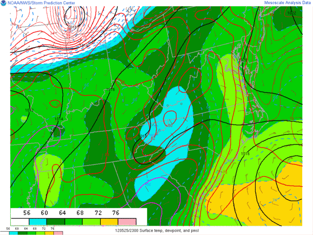
Color Fills and key are for dewpoints.
Last edited by ozonepete on Fri May 25, 2012 7:20 pm, edited 1 time in total.
0 likes
-
TropicalAnalystwx13
- Category 5
- Posts: 2109
- Age: 28
- Joined: Tue Jul 19, 2011 8:20 pm
- Location: Wilmington, NC
- Contact:
The sad thing is that this will be a killer storm. Holiday weekend= Lots of tourists on the beaches, and from Hatteras south to Florida the surf is warm enough so that they will be going for a dip in the surf. Rip currents will claim some. 
0 likes
Ginger-(eye),Dennis,Diana,Kate,Gloria,Charley-(eye),Allison,Arthur,Bertha,Fran,Josephine,Bonnie,Earl,Dennis-(twice),Floyd, Isabel-(eye),Charley,Ophelia-(eyewall),Ernesto,Barry,Hanna,Irene-(eye),Arthur-(eye), Florence, Dorian, and countless depressions, storms, and nor'easters.
Re: ATL: INVEST 94L
Pretty good CAPE surrounding the circulation ranging from 500 to the NE to 2500 to the SW of the LLC.
http://www.spc.noaa.gov/exper/mesoanaly ... underlay=1
http://www.spc.noaa.gov/exper/mesoanaly ... underlay=1
0 likes
-
ozonepete
- Professional-Met
- Posts: 4743
- Joined: Mon Sep 07, 2009 3:23 pm
- Location: From Ozone Park, NYC / Now in Brooklyn, NY
Re: ATL: INVEST 94L
0 likes
-
TropicalAnalystwx13
- Category 5
- Posts: 2109
- Age: 28
- Joined: Tue Jul 19, 2011 8:20 pm
- Location: Wilmington, NC
- Contact:
SPECIAL TROPICAL WEATHER OUTLOOK
NWS NATIONAL HURRICANE CENTER MIAMI FL
845 PM EDT FRI MAY 25 2012
FOR THE NORTH ATLANTIC...CARIBBEAN SEA AND THE GULF OF MEXICO...
SATELLITE PICTURES AND REPORTS FROM NOAA BUOY 41002 INDICATE THAT
THE LOW PRESSURE AREA...CENTERED ABOUT 300 MILES EAST OF CHARLESTON
SOUTH CAROLINA...IS BECOMING BETTER DEFINED AND HAS DEVELOPED
THUNDERSTORM ACTIVITY NEAR THE CENTER. IF CURRENT TRENDS
CONTINUE...ADVISORIES COULD BE INITIATED LATER TONIGHT. THIS SYSTEM
HAS A HIGH CHANCE...NEAR 100 PERCENT...OF BECOMING A SUBTROPICAL OR
TROPICAL CYCLONE DURING THE NEXT 48 HOURS. LITTLE MOTION IS
EXPECTED TONIGHT...BUT A WEST-SOUTHWESTWARD OR SOUTHWESTWARD MOTION
SHOULD BEGIN TOMORROW AND CONTINUE THROUGH SUNDAY. COASTAL
INTERESTS FROM THE CAROLINAS SOUTHWARD THROUGH NORTHEASTERN FLORIDA
SHOULD MONITOR THE PROGRESS OF THIS SYSTEM OVER THE MEMORIAL DAY
WEEKEND. IN ADDITION...LOCALLY HEAVY RAINFALL AND FLOODING WILL
CONTINUE THROUGH AT LEAST TONIGHT OVER PORTIONS OF CENTRAL CUBA AND
THE CENTRAL BAHAMAS. FOR ADDITIONAL INFORMATION ON THIS
SYSTEM...PLEASE SEE HIGH SEAS FORECASTS ISSUED BY THE NATIONAL
WEATHER SERVICE...AND PRODUCTS FROM YOUR LOCAL WEATHER OFFICE.
ELSEWHERE...TROPICAL CYCLONE FORMATION IS NOT EXPECTED DURING THE
NEXT 48 HOURS.
&&
Last edited by TropicalAnalystwx13 on Fri May 25, 2012 7:56 pm, edited 1 time in total.
0 likes
-
Evil Jeremy

- S2K Supporter

- Posts: 5463
- Age: 32
- Joined: Mon Apr 10, 2006 2:10 pm
- Location: Los Angeles, CA
Re: ATL:INVEST 94L-Special Tropical Weather Outlook-Near 100%
Renumber should be any moment now
0 likes
Frances 04 / Jeanne 04 / Katrina 05 / Wilma 05 / Fay 08 / Debby 12 / Andrea 13 / Colin 16 / Hermine 16 / Matthew 16 / Irma 17
I think they'll pull the trigger at 11 and issue watches with that package since the system is likely within 48 hours of impact.
Personal Forecast Disclaimer:
The posts in this forum are NOT official forecast and should not be used as such. They are just the opinion of the poster and may or may not be backed by sound meteorological data. They are NOT endorsed by any professional institution or storm2k.org. For official information, please refer to the NHC and NWS products.
0 likes
-
cycloneye
- Admin
- Posts: 148737
- Age: 69
- Joined: Thu Oct 10, 2002 10:54 am
- Location: San Juan, Puerto Rico
Re: ATL:INVEST 94L-Special Tropical Weather Outlook-Near 100%
And with this fresh scat,I think they will do it.

0 likes
Visit the Caribbean-Central America Weather Thread where you can find at first post web cams,radars
and observations from Caribbean basin members Click Here
and observations from Caribbean basin members Click Here
-
Hurricane Andrew

- S2K Supporter
- Posts: 1891
- Age: 27
- Joined: Sun May 23, 2010 2:53 pm
- Location: KS
Here is a link to the individual renumber page.
http://ftp.nhc.noaa.gov/atcf/tcweb/inve ... 022012.ren
http://ftp.nhc.noaa.gov/atcf/tcweb/inve ... 022012.ren
0 likes
The Enthusiast
NREMT-AEMT, WX nerd
Irene '11, Sandy '12, Irma '17 (SAR)
"Hard to think we were born to live this way..." -Wage War
-
northjaxpro

- S2K Supporter
- Posts: 8900
- Joined: Mon Sep 27, 2010 11:21 am
- Location: Jacksonville, FL
Yeah, no doubt advisories wll be initiated later tonight along with TS watch along the NE FL, GA and SC coasts.
0 likes
NEVER, EVER SAY NEVER in the tropics and weather in general, and most importantly, with life itself!!
________________________________________________________________________________________
Fay 2008 Beryl 2012 Debby 2012 Colin 2016 Hermine 2016 Julia 2016 Matthew 2016 Irma 2017 Dorian 2019
________________________________________________________________________________________
Fay 2008 Beryl 2012 Debby 2012 Colin 2016 Hermine 2016 Julia 2016 Matthew 2016 Irma 2017 Dorian 2019
Who is online
Users browsing this forum: No registered users and 88 guests