ATL: BERYL - Post-Tropical
Moderator: S2k Moderators

Re: ATL: INVEST 94L-Breaking News=94L is renumbered as AL02
Interesting view as things unfold http://www.ssd.noaa.gov/goes/east/eaus/flash-wv.html
0 likes
-
HurricaneBelle

- S2K Supporter

- Posts: 1209
- Joined: Sun Aug 27, 2006 6:12 pm
- Location: Clearwater, FL

-
TropicalAnalystwx13

- Category 5

- Posts: 2109
- Age: 28
- Joined: Tue Jul 19, 2011 8:20 pm
- Location: Wilmington, NC
- Contact:
-
cycloneye

- Admin

- Posts: 149286
- Age: 69
- Joined: Thu Oct 10, 2002 10:54 am
- Location: San Juan, Puerto Rico
Re:
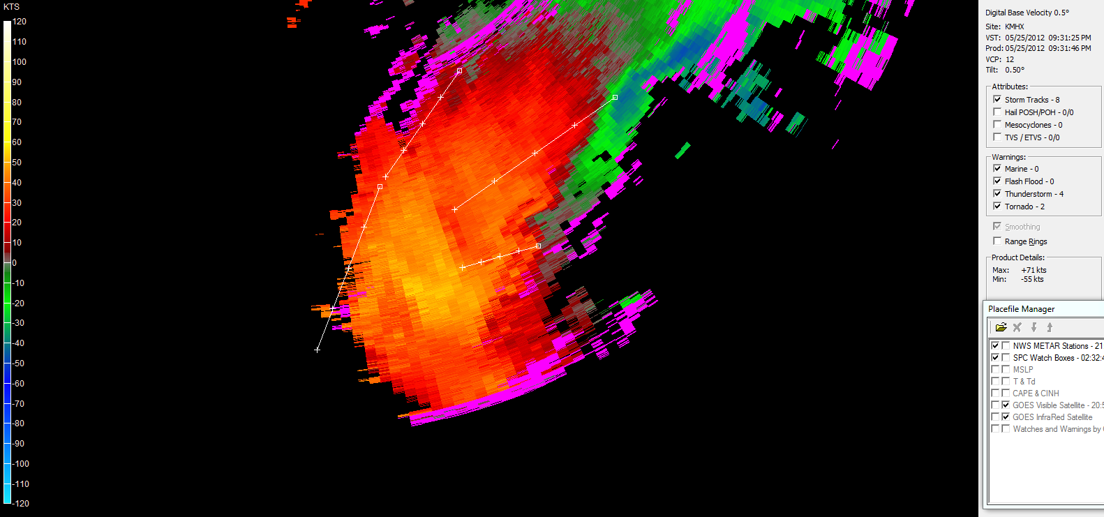
TropicalAnalystwx13 wrote:Radar shows that Beryl has winds of 73 mph 19 kft up.
Do you have the link to the radar?
0 likes
Visit the Caribbean-Central America Weather Thread where you can find at first post web cams,radars
and observations from Caribbean basin members Click Here
and observations from Caribbean basin members Click Here
-
TropicalAnalystwx13
- Category 5
- Posts: 2109
- Age: 28
- Joined: Tue Jul 19, 2011 8:20 pm
- Location: Wilmington, NC
- Contact:
-
thundercam96

- Tropical Storm

- Posts: 129
- Joined: Thu Aug 18, 2011 3:01 pm
- Location: Boston, MA
Re: Re:
FutureEM wrote:TropicalAnalystwx13 wrote:Radar shows that Beryl has winds of 73 mph 19 kft up.
I'm still learning, but that sounds weird to me.
Same Here, Learning As I Go Along
0 likes
Fay '08 / Mathew 16'
Personal Forecast Disclaimer: I am not a certified meteorologist, therefore, what is posted on this forum under my header should not be treated as an official forecast. Please refer to the NWS/NHC products for forecast information.
Personal Forecast Disclaimer: I am not a certified meteorologist, therefore, what is posted on this forum under my header should not be treated as an official forecast. Please refer to the NWS/NHC products for forecast information.
-
Hurricaneman

- Category 5
- Posts: 7404
- Age: 45
- Joined: Tue Aug 31, 2004 3:24 pm
- Location: central florida
Re:
TropicalAnalystwx13 wrote:Radar shows that Beryl has winds of 73 mph 19 kft up.
What would that reduce to on the surface
0 likes
-
cycloneye
- Admin
- Posts: 149286
- Age: 69
- Joined: Thu Oct 10, 2002 10:54 am
- Location: San Juan, Puerto Rico
Re: ATL: INVEST 94L-Breaking News=94L is renumbered as AL02
0 likes
Visit the Caribbean-Central America Weather Thread where you can find at first post web cams,radars
and observations from Caribbean basin members Click Here
and observations from Caribbean basin members Click Here
-
ozonepete
- Professional-Met

- Posts: 4743
- Joined: Mon Sep 07, 2009 3:23 pm
- Location: From Ozone Park, NYC / Now in Brooklyn, NY
Re:
TropicalAnalystwx13 wrote:It's a radar program called GR2Analyst.
I know of that program and have friends who run radar analysis from it for me since I don't have it and have never used it myself. Can you post a velocity image that shows what you were saying? If you can't it's ok, but you need to back stuff up here because we try to stay as professional as we can, ok?
0 likes
-
TropicalAnalystwx13
- Category 5
- Posts: 2109
- Age: 28
- Joined: Tue Jul 19, 2011 8:20 pm
- Location: Wilmington, NC
- Contact:
Re: Re:
ozonepete wrote:TropicalAnalystwx13 wrote:It's a radar program called GR2Analyst.
I know of that program and have friends who run radar analysis from it for me since I don't have it and have never used it myself. Can you post a velocity image that shows what you were saying? If you can't it's ok, but you need to back stuff up here because we try to stay as professional as we can, ok?
Yeah...that would be kinda hard to do.
0 likes
-
TropicalAnalystwx13
- Category 5
- Posts: 2109
- Age: 28
- Joined: Tue Jul 19, 2011 8:20 pm
- Location: Wilmington, NC
- Contact:

Re: Re:
TropicalAnalystwx13 wrote:ozonepete wrote:TropicalAnalystwx13 wrote:It's a radar program called GR2Analyst.
I know of that program and have friends who run radar analysis from it for me since I don't have it and have never used it myself. Can you post a velocity image that shows what you were saying? If you can't it's ok, but you need to back stuff up here because we try to stay as professional as we can, ok?
Yeah...that would be kinda hard to do.
Would you have the raw data from something like that? I mean a screenshot would probably be copyrighted, but the data itself might not be. It would be pretty interesting to see what you are talking about.
0 likes


This might have already been brought up, but 1887 and 1908 are the only years I found that officially had more than one tropical/subtropical storm before the start of hurricane season. 1969 had two Tropical Depressions form before June.
Last edited by Buck on Sat May 26, 2012 6:27 am, edited 1 time in total.
0 likes
Re: ATL: INVEST 94L
A TROPICAL STORM WARNING HAS BEEN ISSUED ALONG THE SOUTHEASTERN
UNITED STATES COAST...FROM THE VOLUSIA/BREVARD COUNTY LINE IN
NORTHEAST FLORIDA NORTHWARD TO EDISTO BEACH SOUTH CAROLINA
A TROPICAL STORM WATCH HAS BEEN ISSUED FROM NORTH OF EDISTO BEACH
SOUTH TO SOUTH SANTEE RIVER SOUTH CAROLINA
UNITED STATES COAST...FROM THE VOLUSIA/BREVARD COUNTY LINE IN
NORTHEAST FLORIDA NORTHWARD TO EDISTO BEACH SOUTH CAROLINA
A TROPICAL STORM WATCH HAS BEEN ISSUED FROM NORTH OF EDISTO BEACH
SOUTH TO SOUTH SANTEE RIVER SOUTH CAROLINA
0 likes


Re: ATL: INVEST 94L
It's official, welcome Beryl!!! Don't cause any problems. Interesting start to the season for sure.
0 likes
Who is online
Users browsing this forum: No registered users and 17 guests