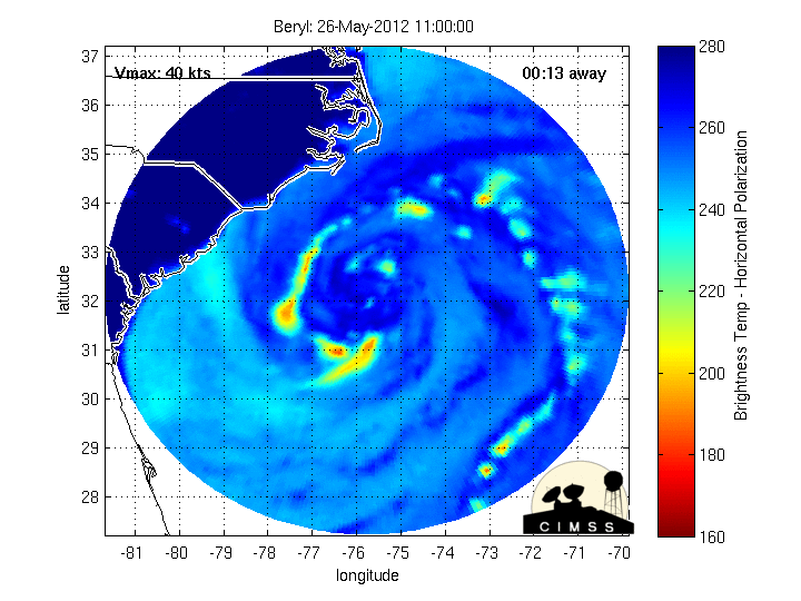
WV Loop
http://www.ssd.noaa.gov/PS/TROP/floater ... short.html
ATL: BERYL - Post-Tropical
Moderator: S2k Moderators
-
Hurricane Andrew

- S2K Supporter

- Posts: 1891
- Age: 27
- Joined: Sun May 23, 2010 2:53 pm
- Location: KS

-
ozonepete
- Professional-Met

- Posts: 4743
- Joined: Mon Sep 07, 2009 3:23 pm
- Location: From Ozone Park, NYC / Now in Brooklyn, NY
Re: ATL: BERYL - Subtropical Storm
Unfortunately this is looking like a dry storm in a dry season. Let's hope it can moisten up a little more but it's running out of time.
0 likes
-
cycloneye

- Admin

- Posts: 149291
- Age: 69
- Joined: Thu Oct 10, 2002 10:54 am
- Location: San Juan, Puerto Rico
Re: ATL: BERYL - Subtropical Storm
ozonepete wrote:Unfortunately this is looking like a dry storm in a dry season. Let's hope it can moisten up a little more but it's running out of time.
I thought that she made a little run in the afternoon hours to the transition as convection bloosomed,but the upper low is still there not allowing an antiyclone to form and as you said,time is running out.
0 likes
Visit the Caribbean-Central America Weather Thread where you can find at first post web cams,radars
and observations from Caribbean basin members Click Here
and observations from Caribbean basin members Click Here

Re: ATL: BERYL - Subtropical Storm
ozonepete wrote:Unfortunately this is looking like a dry storm in a dry season. Let's hope it can moisten up a little more but it's running out of time.
Us Georgians could sure benefit from Beryl deepening a bit before she pays us a visit!
0 likes
-
ozonepete
- Professional-Met
- Posts: 4743
- Joined: Mon Sep 07, 2009 3:23 pm
- Location: From Ozone Park, NYC / Now in Brooklyn, NY
Re: ATL: BERYL - Subtropical Storm
Well, keep up the hope. It is a classic scenario for a stalling tropical cyclone to produce prodigious rainfall amounts. So let's hope that Bery stalls out over the Florida panhandle and then slowly turns back east, even more slowly than forecast. That will allow the rain shield to expand and because of good vertical ascent but less entrainment of dry air it could produce a lot of rainfall. A win/win for all of you down there. There's a pretty good chance it could happen. We'll keep our fingers crossed.
Last edited by ozonepete on Sat May 26, 2012 9:39 pm, edited 1 time in total.
0 likes
-
cycloneye
- Admin
- Posts: 149291
- Age: 69
- Joined: Thu Oct 10, 2002 10:54 am
- Location: San Juan, Puerto Rico
Re: ATL: BERYL - Advisories
BULLETIN
SUBTROPICAL STORM BERYL ADVISORY NUMBER 5
NWS NATIONAL HURRICANE CENTER MIAMI FL AL022012
1100 PM EDT SAT MAY 26 2012
...BERYL MOVING SOUTHWESTWARD WITH LITTLE CHANGE IN STRENGTH...
SUMMARY OF 1100 PM EDT...0300 UTC...INFORMATION
-----------------------------------------------
LOCATION...30.8N 77.2W
ABOUT 215 MI...345 KM SE OF CHARLESTON SOUTH CAROLINA
ABOUT 270 MI...435 KM E OF JACKSONVILLE FLORIDA
MAXIMUM SUSTAINED WINDS...50 MPH...85 KM/H
PRESENT MOVEMENT...SW OR 230 DEGREES AT 7 MPH...11 KM/H
MINIMUM CENTRAL PRESSURE...998 MB...29.47 INCHES
WATCHES AND WARNINGS
--------------------
CHANGES WITH THIS ADVISORY...
THE TROPICAL STORM WATCH FOR THE SOUTH CAROLINA COAST NORTH OF
EDISTO BEACH HAS BEEN DISCONTINUED.
SUMMARY OF WATCHES AND WARNINGS IN EFFECT...
A TROPICAL STORM WARNING IS IN EFFECT FOR...
* VOLUSIA/BREVARD COUNTY LINE FLORIDA TO EDISTO BEACH SOUTH CAROLINA
FOR STORM INFORMATION SPECIFIC TO YOUR AREA...INCLUDING POSSIBLE
INLAND WATCHES AND WARNINGS...PLEASE MONITOR PRODUCTS ISSUED BY
YOUR LOCAL NATIONAL WEATHER SERVICE FORECAST OFFICE.
DISCUSSION AND 48-HOUR OUTLOOK
------------------------------
AT 1100 PM EDT...0300 UTC...THE CENTER OF SUBTROPICAL STORM BERYL
WAS LOCATED NEAR LATITUDE 30.8 NORTH...LONGITUDE 77.2 WEST. THE
STORM IS MOVING TOWARD THE SOUTHWEST NEAR 7 MPH...11 KM/H. THIS
GENERAL MOTION IS EXPECTED TO CONTINUE TONIGHT...WITH A TURN TOWARD
THE WEST FORECAST ON SUNDAY. ON THE FORECAST TRACK...THE CENTER OF
BERYL IS EXPECTED TO APPROACH THE SOUTHEASTERN COAST OF THE UNITED
STATES ON SUNDAY...AND THEN MAKE LANDFALL SUNDAY NIGHT OR MONDAY.
MAXIMUM SUSTAINED WINDS ARE NEAR 50 MPH...85 KM/H...WITH HIGHER
GUSTS. LITTLE CHANGE IN STRENGTH IS EXPECTED BEFORE LANDFALL...WITH
WEAKENING EXPECTED AFTER LANDFALL.
TROPICAL-STORM-FORCE WINDS EXTEND OUTWARD UP TO 90 MILES...150 KM
FROM THE CENTER.
THE ESTIMATED MINIMUM CENTRAL PRESSURE IS 998 MB...29.47 INCHES.
HAZARDS AFFECTING LAND
----------------------
WIND...TROPICAL STORM CONDITIONS ARE EXPECTED TO REACH THE COAST
WITHIN THE WARNING AREA FROM NORTHEASTERN FLORIDA TO SOUTH CAROLINA
ON SUNDAY.
STORM SURGE...THE COMBINATION OF A STORM SURGE AND THE TIDE WILL
CAUSE NORMALLY DRY AREAS NEAR THE COAST TO BE FLOODED BY RISING
WATERS. THE WATER COULD REACH THE FOLLOWING DEPTHS ABOVE GROUND IF
THE PEAK SURGE OCCURS AT THE TIME OF HIGH TIDE...
COASTAL PORTIONS OF SOUTH CAROLINA...GEORGIA...AND NORTH FLORIDA...
1 TO 3 FT
THE DEEPEST WATER WILL OCCUR ALONG THE IMMEDIATE COAST NEAR AND TO
THE NORTH OF THE LANDFALL LOCATION...WHERE THE SURGE WILL BE
ACCOMPANIED BY LARGE WAVES. SURGE-RELATED FLOODING DEPENDS ON THE
RELATIVE TIMING OF THE SURGE AND THE TIDAL CYCLE...AND CAN VARY
GREATLY OVER SHORT DISTANCES. FOR INFORMATION SPECIFIC TO YOUR
AREA...PLEASE SEE PRODUCTS ISSUED BY YOUR LOCAL NATIONAL WEATHER
SERVICE OFFICE.
SURF...DANGEROUS SURF CONDITIONS ARE EXPECTED ALONG THE COAST FROM
NORTHEASTERN FLORIDA TO NORTH CAROLINA OVER THE REMAINDER OF THE
MEMORIAL DAY WEEKEND. PLEASE SEE STATEMENTS ISSUED BY YOUR LOCAL
NATIONAL WEATHER SERVICE OFFICE FOR INFORMATION SPECIFIC TO YOUR
AREA.
RAINFALL...BERYL IS EXPECTED TO PRODUCE TOTAL RAIN ACCUMULATIONS OF
3 TO 6 INCHES ALONG THE SOUTHEASTERN COAST OF THE UNITED STATES
FROM NORTHERN FLORIDA THROUGH SOUTHEASTERN NORTH CAROLINA.
NEXT ADVISORY
-------------
NEXT INTERMEDIATE ADVISORY...200 AM EDT.
NEXT COMPLETE ADVISORY...500 AM EDT.
$$
FORECASTER BEVEN
SUBTROPICAL STORM BERYL DISCUSSION NUMBER 5
NWS NATIONAL HURRICANE CENTER MIAMI FL AL022012
1100 PM EDT SAT MAY 26 2012
AN AIR FORCE RESERVE HURRICANE HUNTER AIRCRAFT INVESTIGATING BERYL
THIS AFTERNOON FOUND THAT THE STORM WAS A LITTLE STRONGER THAN
PREVIOUSLY ANALYZED. THE CENTRAL PRESSURE WAS 998 MB...WITH
MAXIMUM FLIGHT-LEVEL WINDS OF 55 KT AND SURFACE WIND ESTIMATES OF
40-45 KT FROM THE SFMR. BASED ON THESE DATA...THE INITIAL INTENSITY
HAS BEEN INCREASED TO 45 KT. STRUCTURALLY...THE CYCLONE HAS
CHANGED LITTLE DURING THE PAST SEVERAL HOURS AS TRANSIENT BANDS OF
CONVECTION FORM NEAR THE CENTER.
THE INITIAL MOTION IS NOW 230/6...AND THE SHORT-TERM MOTION MAY BE A
LITTLE FASTER. BERYL IS EMBEDDED IN A LARGE MID-/UPPER-LEVEL LOW
THAT IS MOVING SOUTHWESTWARD AS A STRONG RIDGE DEVELOPS TO ITS
NORTHWEST OVER THE EASTERN UNITED STATES. THE DYNAMICAL MODELS
FORECAST THIS RIDGE TO MOVE EASTWARD DURING THE NEXT 36 H...AND
THEN WEAKEN IT AS A LARGE DEEP-LAYER TROUGH MOVES EASTWARD FROM THE
CENTRAL UNITED STATES. THIS EVOLUTION SHOULD CAUSE BERYL TO TURN
WESTWARD AND MAKE LANDFALL IN THE SOUTHEASTERN UNITED STATES
BETWEEN 24-36 H. AFTER THAT TIME...THE TRACK GUIDANCE AGREES THAT
THE CYCLONE WILL STALL AND THEN TURN NORTHEASTWARD. HOWEVER...
THERE IS A LARGE SPREAD ON WHERE AND WHEN THIS WILL OCCUR BETWEEN
THE EASTERNMOST ECMWF AND THE OTHER MODELS. THE NEW FORECAST TRACK
HAS BEEN SHIFTED A LITTLE TO THE WEST OF THE PREVIOUS TRACK THROUGH
48 H...BUT REMAINS EAST OF THE CENTER OF THE GUIDANCE ENVELOPE IN
DEFERENCE TO THE USUALLY-RELIABLE ECMWF. AFTER RECURVATURE...THE
GUIDANCE AGREES THAT BERYL WILL ACCELERATE NORTHEASTWARD...AND THIS
IS REFLECTED IN THE OFFICIAL FORECAST. OVERALL...THE NEW FORECAST
TRACK IS FASTER THAN THE PREVIOUS ONE.
SATELLITE IMAGERY AND MICROWAVE PRECIPITABLE WATER DATA SUGGEST THAT
THE ENVIRONMENT NEAR BERYL IS BECOMING MORE MOIST...AND THE
CONVECTION IS GRADUALLY GETTING BETTER ORGANIZED AROUND THE CENTER.
THESE TWO FACTORS SHOULD LEAD TO THE TRANSITION OF BERYL INTO A
TROPICAL CYCLONE BEFORE LANDFALL. HOWEVER...THE INTENSITY GUIDANCE
DOES NOT FORECAST SIGNIFICANT STRENGTHENING DURING THIS PROCESS.
BERYL SHOULD SUBSEQUENTLY WEAKEN TO A TROPICAL DEPRESSION OVER
LAND. AFTER RECURVATURE...THE DYNAMICAL MODELS ARE IN GOOD
AGREEMENT THAT BERYL SHOULD RE-INTENSIFY OVER THE ATLANTIC DESPITE
THE PRESENCE OF SIGNIFICANT VERTICAL WIND SHEAR. THE NEW FORECAST
SHOWS A LITTLE MORE STRENGTHENING THAN THE PREVIOUS FORECAST BASED
MAINLY ON THE LGEM MODEL.
THE ANALYZED AND FORECAST WIND RADII HAVE BEEN REDUCED BASED ON THE
AIRCRAFT DATA.
FORECAST POSITIONS AND MAX WINDS
INIT 27/0300Z 30.8N 77.2W 45 KT 50 MPH
12H 27/1200Z 30.4N 78.8W 45 KT 50 MPH
24H 28/0000Z 30.2N 80.9W 45 KT 50 MPH...TROPICAL
36H 28/1200Z 30.3N 82.2W 40 KT 45 MPH...INLAND
48H 29/0000Z 30.7N 82.4W 30 KT 35 MPH...INLAND
72H 30/0000Z 32.0N 81.0W 30 KT 35 MPH...INLAND
96H 31/0000Z 35.0N 75.5W 40 KT 45 MPH...OVER WATER
120H 01/0000Z 39.0N 66.0W 45 KT 50 MPH...POST-TROP/EXTRATROP
$$
FORECASTER BEVEN
0 likes
Visit the Caribbean-Central America Weather Thread where you can find at first post web cams,radars
and observations from Caribbean basin members Click Here
and observations from Caribbean basin members Click Here
-
bamajammer4eva
- Category 4

- Posts: 907
- Joined: Sun Apr 18, 2010 3:21 am
- Location: Ozark, AL
Re: ATL: BERYL - Subtropical Storm
ozonepete wrote:Unfortunately this is looking like a dry storm in a dry season. Let's hope it can moisten up a little more but it's running out of time.
Yes but wouldn't the onshore flows from both the Atlantic and the Gulf after landfall generate some decent bands of showers in itself?
0 likes
-
ozonepete
- Professional-Met
- Posts: 4743
- Joined: Mon Sep 07, 2009 3:23 pm
- Location: From Ozone Park, NYC / Now in Brooklyn, NY
Re: ATL: BERYL - Subtropical Storm
bamajammer4eva wrote:ozonepete wrote:Unfortunately this is looking like a dry storm in a dry season. Let's hope it can moisten up a little more but it's running out of time.
Yes but wouldn't the onshore flows from both the Atlantic and the Gulf after landfall generate some decent bands of showers in itself?
Yes. Good point. And you can see what I just posted before you posted this.
0 likes
-
ouragans

- Category 2

- Posts: 501
- Age: 54
- Joined: Sun Jun 12, 2011 12:09 pm
- Location: Abymes, Guadeloupe F.W.I
- Contact:
Re: ATL: BERYL - Subtropical Storm
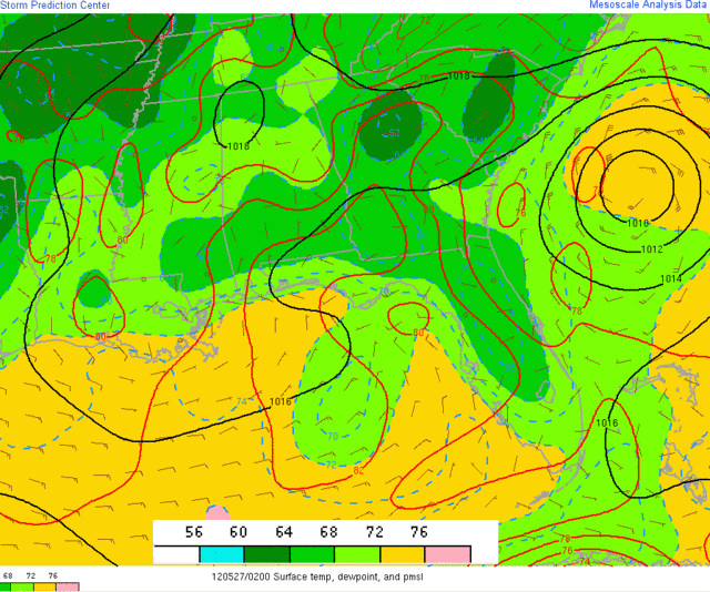
Don't consider that because Beryl does not have moisture now, that it won't have it tomorrow. This stormmoves slowly on high SSTs. Despite the surrounding dry air, it should be ready to give you some kind of relief, IMHO
0 likes
Personal forecast disclaimer
This post is a personal point of view, not an information. Please refer to official statements for life-threatening decisions.
David '79, Frederic '79, Hugo '89, Iris, Luis & Marilyn '95, Georges '98, Lenny '99, Dean '07, Irma '17, Maria '17, Fiona '22, Philippe '23, Tammy '23
16°13'33.3,"6N -61°36'39.5"W
-
ocala
- Tropical Depression

- Posts: 88
- Joined: Sat Apr 08, 2006 8:48 am
- Location: Candler,Florida
- Contact:
Re: ATL: BERYL - Subtropical Storm
ozonepete wrote:Well, keep up the hope. It is a classic scenario for a stalling tropical cyclone to produce prodigious rainfall amounts. So let's hope that Bery stalls out over the Florida panhandle and then slowly turns back east, even more slowly than forecast. That will allow the rain shield to expand and because of good vertical ascent but less entrainment of dry air it could produce a lot of rainfall. A win/win for all of you down there. There's a pretty good chance it could happen. We'll keep our fingers crossed.
In this scenario would the rain shield be generally to the east and south?
0 likes
-
cycloneye
- Admin
- Posts: 149291
- Age: 69
- Joined: Thu Oct 10, 2002 10:54 am
- Location: San Juan, Puerto Rico
Re: ATL: BERYL - Subtropical Storm
Am excerpt from 11 PM EDT discussion:
SATELLITE IMAGERY AND MICROWAVE PRECIPITABLE WATER DATA SUGGEST THAT
THE ENVIRONMENT NEAR BERYL IS BECOMING MORE MOIST...AND THE
CONVECTION IS GRADUALLY GETTING BETTER ORGANIZED AROUND THE CENTER.
THESE TWO FACTORS SHOULD LEAD TO THE TRANSITION OF BERYL INTO A
TROPICAL CYCLONE BEFORE LANDFALL. HOWEVER...THE INTENSITY GUIDANCE
DOES NOT FORECAST SIGNIFICANT STRENGTHENING DURING THIS PROCESS.
0 likes
Visit the Caribbean-Central America Weather Thread where you can find at first post web cams,radars
and observations from Caribbean basin members Click Here
and observations from Caribbean basin members Click Here
-
ozonepete
- Professional-Met
- Posts: 4743
- Joined: Mon Sep 07, 2009 3:23 pm
- Location: From Ozone Park, NYC / Now in Brooklyn, NY
Re: ATL: BERYL - Subtropical Storm
0 likes
Re: ATL: BERYL - Subtropical Storm
Beryl - and her ULL friend - could actually become a huge storm - if they had 3-4 days of 82 degree open water in front of them. Duel engines?
These Hybrids have become the norm - ULL & Dry air have ruled last 3 years
http://www.ssec.wisc.edu/data/geo/index ... thod=flash
These Hybrids have become the norm - ULL & Dry air have ruled last 3 years
http://www.ssec.wisc.edu/data/geo/index ... thod=flash
0 likes
-
ozonepete
- Professional-Met
- Posts: 4743
- Joined: Mon Sep 07, 2009 3:23 pm
- Location: From Ozone Park, NYC / Now in Brooklyn, NY
Re: ATL: BERYL - Subtropical Storm
ocala wrote:ozonepete wrote:Well, keep up the hope. It is a classic scenario for a stalling tropical cyclone to produce prodigious rainfall amounts. So let's hope that Bery stalls out over the Florida panhandle and then slowly turns back east, even more slowly than forecast. That will allow the rain shield to expand and because of good vertical ascent but less entrainment of dry air it could produce a lot of rainfall. A win/win for all of you down there. There's a pretty good chance it could happen. We'll keep our fingers crossed.
In this scenario would the rain shield be generally to the east and south?
Should be more over the east and north. While some pretty good rains should extend south of the center, if the forecast track holds up and it moves at a slow rate of speed it should produce the best rains over coastal Georgia, SC and SC. Central Florida would get some rain but lesser amounts from scattered thunderstorms as the low pushes and lifts Gulf moisture over it.
0 likes

Re: ATL: BERYL - Subtropical Storm
Surf for the morning will be phenomenal for N FL! Winds are NW at 3 at the Saint Augustine pier with NE swells of 6-7 feet offshore.
0 likes
The following post is NOT an official forecast and should not be used as such. It is just the opinion of the poster and may or may not be backed by sound meteorological data. It is NOT endorsed by any professional institution including storm2k.org For Official Information please refer to the NHC and NWS products.
-
WilmingtonSandbar
- S2K Supporter
- Posts: 505
- Joined: Sun Aug 29, 2010 12:11 pm
- Location: Southport, NC
-
cycloneye
- Admin
- Posts: 149291
- Age: 69
- Joined: Thu Oct 10, 2002 10:54 am
- Location: San Juan, Puerto Rico
Re: ATL: BERYL - Subtropical Storm

0 likes
Visit the Caribbean-Central America Weather Thread where you can find at first post web cams,radars
and observations from Caribbean basin members Click Here
and observations from Caribbean basin members Click Here
-
Bocadude85

- Category 5

- Posts: 2991
- Age: 39
- Joined: Mon Apr 18, 2005 2:20 pm
- Location: Honolulu,Hi
Re: ATL: BERYL - Subtropical Storm
Convection is really starting to blossom now
http://www.ssd.noaa.gov/PS/TROP/floaters/02L/java-rb-long.html
http://www.ssd.noaa.gov/PS/TROP/floaters/02L/java-rb-long.html
0 likes
-
ozonepete
- Professional-Met
- Posts: 4743
- Joined: Mon Sep 07, 2009 3:23 pm
- Location: From Ozone Park, NYC / Now in Brooklyn, NY
Re: ATL: BERYL - Subtropical Storm
cycloneye wrote:The moist enviroment looks to be dominating as the dry air is less.
Yup. Surface dewpoints coming up more and more. A good sign.
0 likes
Who is online
Users browsing this forum: No registered users and 10 guests