First broken sprial band line is currently moving ashore along the SE GA coast around Saint Simons island and rotating down towards Fernandina Beach. I may see the first light rain or sprinkles from this shortly as it moves down across the Nassau-Duval county line.
Just measured a wind gust to 27 mph just a few moments ago. Winds picking up gradually here at my home location.
ATL: BERYL - Post-Tropical
Moderator: S2k Moderators
-
northjaxpro

- S2K Supporter

- Posts: 8900
- Joined: Mon Sep 27, 2010 11:21 am
- Location: Jacksonville, FL
-
cycloneye

- Admin

- Posts: 149287
- Age: 69
- Joined: Thu Oct 10, 2002 10:54 am
- Location: San Juan, Puerto Rico
Re: ATL: BERYL - Recon Discussion
Plane is acending so mission is over.
0 likes
Visit the Caribbean-Central America Weather Thread where you can find at first post web cams,radars
and observations from Caribbean basin members Click Here
and observations from Caribbean basin members Click Here


Re: ATL: BERYL - Subtropical Storm
HUC wrote:HEY guys,i come back on the board after some vertebral column problems, but all is fine now.
Seems some winds coming for you...
Someone got a web cam in the area cocerned??
Thank's and Hello LUIS.
http://www.jaxpiercam.com/
http://www.webcamgalore.com/EN/webcam-m ... y-805.html
http://bridgemonitoring.com/Bridges/DP/DP.htm
http://www.firstcoastnews.com/travel/tr ... fault.aspx (FDOT Cameras)
http://www.actionnewsjax.com/content/to ... fault.aspx
0 likes
-
northjaxpro
- S2K Supporter
- Posts: 8900
- Joined: Mon Sep 27, 2010 11:21 am
- Location: Jacksonville, FL
Jdray, what part of NE FL are you in right now?
0 likes
NEVER, EVER SAY NEVER in the tropics and weather in general, and most importantly, with life itself!!
________________________________________________________________________________________
Fay 2008 Beryl 2012 Debby 2012 Colin 2016 Hermine 2016 Julia 2016 Matthew 2016 Irma 2017 Dorian 2019
________________________________________________________________________________________
Fay 2008 Beryl 2012 Debby 2012 Colin 2016 Hermine 2016 Julia 2016 Matthew 2016 Irma 2017 Dorian 2019
Re:
northjaxpro wrote:Jdray, what part of NE FL are you in right now?
Just a little bit south of Oakleaf, trying to get weather station back working lol.
What part are you in?
At least the friendly between USA and Scotland got played last night. (over 44K for a friendly, not too shabby, most ever in Florida)
They have officially cancelled the Jazz Fest now.
0 likes
-
cycloneye
- Admin
- Posts: 149287
- Age: 69
- Joined: Thu Oct 10, 2002 10:54 am
- Location: San Juan, Puerto Rico
Re: ATL: BERYL - Recon
There will be another mission this afternoon.
From yesterdays TCPOD.
From yesterdays TCPOD.
Code: Select all
FLIGHT ONE -- TEAL 70
       A. 27/2200Z
       B. AFXXX 0302A BERYL
       C. 27/1945Z
       D. 30.4N 80.5W
       E. 27/2130Z TO 28/0030Z
       F. SFC TO 10,000 FT
0 likes
Visit the Caribbean-Central America Weather Thread where you can find at first post web cams,radars
and observations from Caribbean basin members Click Here
and observations from Caribbean basin members Click Here
-
northjaxpro
- S2K Supporter
- Posts: 8900
- Joined: Mon Sep 27, 2010 11:21 am
- Location: Jacksonville, FL
Re: Re:
jdray wrote:northjaxpro wrote:Jdray, what part of NE FL are you in right now?
Just a little bit south of Oakleaf, trying to get weather station back working lol.
What part are you in?
I am in the north end of Jacksonville off of US Hwy 17 approximately 5-6 miles just east-northeast of International Airport. I am not t far from the Nassau county line at all. Just about 2-3 miles from there.
Last edited by northjaxpro on Sun May 27, 2012 9:37 am, edited 1 time in total.
0 likes
NEVER, EVER SAY NEVER in the tropics and weather in general, and most importantly, with life itself!!
________________________________________________________________________________________
Fay 2008 Beryl 2012 Debby 2012 Colin 2016 Hermine 2016 Julia 2016 Matthew 2016 Irma 2017 Dorian 2019
________________________________________________________________________________________
Fay 2008 Beryl 2012 Debby 2012 Colin 2016 Hermine 2016 Julia 2016 Matthew 2016 Irma 2017 Dorian 2019
-
Bocadude85

- Category 5

- Posts: 2991
- Age: 39
- Joined: Mon Apr 18, 2005 2:20 pm
- Location: Honolulu,Hi
Re: ATL: BERYL - Subtropical Storm
NDG wrote:tolakram wrote:NDG wrote:I can see them missing the center one time, but twice? I do not know about your thoughts
Have you looked at the sat loop? I think the center is re-organizing, perhaps as it transitions to a tropical system.
Looking at that loop, sped up, Beryl looks serious.
I'm waiting for the headline: Beryl barreling toward Jacksonville!
Stay safe everyone!
Yes I have, but I still see the main circulation near 30.1 not 30.5
She looks to still be moving south of west to me. In my opinion landfall will be closer to St. Augustine
http://radar.weather.gov/radar.php?rid=JAX&product=N0Z&overlay=11101111&loop=yes
0 likes
-
tolakram
- Admin
- Posts: 20179
- Age: 62
- Joined: Sun Aug 27, 2006 8:23 pm
- Location: Florence, KY (name is Mark)
Re: ATL: BERYL - Subtropical Storm
0 likes
M a r k
- - - - -
Join us in chat: Storm2K Chatroom Invite. Android and IOS apps also available.
The posts in this forum are NOT official forecasts and should not be used as such. Posts are NOT endorsed by any professional institution or STORM2K.org. For official information and forecasts, please refer to NHC and NWS products.
-
northjaxpro
- S2K Supporter
- Posts: 8900
- Joined: Mon Sep 27, 2010 11:21 am
- Location: Jacksonville, FL
Getting a bit of light rain moving through now in that broken spiral outer band which i referenced a few moments ago.
0 likes
NEVER, EVER SAY NEVER in the tropics and weather in general, and most importantly, with life itself!!
________________________________________________________________________________________
Fay 2008 Beryl 2012 Debby 2012 Colin 2016 Hermine 2016 Julia 2016 Matthew 2016 Irma 2017 Dorian 2019
________________________________________________________________________________________
Fay 2008 Beryl 2012 Debby 2012 Colin 2016 Hermine 2016 Julia 2016 Matthew 2016 Irma 2017 Dorian 2019
-
Mouton
- S2K Supporter
- Posts: 222
- Age: 80
- Joined: Sat Jul 30, 2011 8:13 am
- Location: Amelia Island Florida
Re:
AmeliaIslandr wrote:Here's a cam from the north end of Amelia Island
http://www.ameliaisland.com/web-cam-6/
I hope when one goes to their "other camera" they do not imply a golf course is at Sandy Bottoms! It is the shot from the Ritz I believe.
Noticed the stay out of the water flags flying at the life guard station. I hope the surfers take head....yesterday they had to drag in from the surf off Little Talbott a would be good sammarital, now in the hospital, after attempting to save two kids who were on buggy boards. They had gotten caught in the Rip. They made it back in OK.
Sun just popped back out here. Barometer still steady. No rain at my home.
0 likes
-
ocala
- Tropical Depression

- Posts: 88
- Joined: Sat Apr 08, 2006 8:48 am
- Location: Candler,Florida
- Contact:
Re:
NDG wrote:So the latitude is 30.1 based on the latest fix, if it continues to move it that heading which I am estimating to be 260 deg, it will be making landfall near Palm Coast to the south of Jacksonville & St Augustine, if it heads due west as expected from this point on it will be making landfall near Ponte Vedra Beach.
The posts in this forum are NOT official forecast and should not be used as such. They are just the opinion of the poster and may or may not be backed by sound meteorological data. They are NOT endorsed by any professional institution or storm2k.org. For official information, please refer to the NHC and NWS products.
If 260 deg holds up that's about a bulls eye for Palm Coast/St Augustine.
Interestingly enough none of the forecasts have gone below 30.0.
Curious how far south the 11AM track will be adjusted. If any.
0 likes

Re: ATL: BERYL - Subtropical Storm
I agree - S. of West
Nothing I can see to lift it more North at this time. Week steering.
Very hard to forecast where Beryl goes over next few days.
Nothing I can see to lift it more North at this time. Week steering.
Very hard to forecast where Beryl goes over next few days.
0 likes
-
tolakram
- Admin
- Posts: 20179
- Age: 62
- Joined: Sun Aug 27, 2006 8:23 pm
- Location: Florence, KY (name is Mark)
Re: ATL: BERYL - Subtropical Storm
Latest

0 likes
M a r k
- - - - -
Join us in chat: Storm2K Chatroom Invite. Android and IOS apps also available.
The posts in this forum are NOT official forecasts and should not be used as such. Posts are NOT endorsed by any professional institution or STORM2K.org. For official information and forecasts, please refer to NHC and NWS products.
- - - - -
Join us in chat: Storm2K Chatroom Invite. Android and IOS apps also available.
The posts in this forum are NOT official forecasts and should not be used as such. Posts are NOT endorsed by any professional institution or STORM2K.org. For official information and forecasts, please refer to NHC and NWS products.
-
wxman57

- Moderator-Pro Met

- Posts: 23172
- Age: 68
- Joined: Sat Jun 21, 2003 8:06 pm
- Location: Houston, TX (southwest)
Re: ATL: BERYL - Subtropical Storm
It's a very broad center with a couple of vortices rotating around. 1430Z image makes the center appear near 30.2N/79.7W, which is 119 miles ESE of Jacksonville. Movement in the past few hours is just a hair south of due west. The center should move inland around 30N, or about 40 miles SE of Jacksonville. Just about 90 miles to go before landfall.
Still no convection over the center. I expect that any TS force winds will remain right on the coast as it moves ashore. Could see gusts 40-55 mph across Jacksonville this evening. A good bit of rain from NE FL through SE GA appears likely.
Still no convection over the center. I expect that any TS force winds will remain right on the coast as it moves ashore. Could see gusts 40-55 mph across Jacksonville this evening. A good bit of rain from NE FL through SE GA appears likely.
0 likes

I still see the true broad center of circulation near 30.1 N based on this satellite loop.
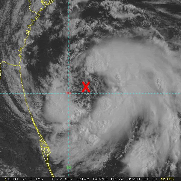
http://rammb.cira.colostate.edu/product ... 262202.GIF
http://rammb.cira.colostate.edu/product ... 262202.GIF
0 likes
-
northjaxpro
- S2K Supporter
- Posts: 8900
- Joined: Mon Sep 27, 2010 11:21 am
- Location: Jacksonville, FL
Mouton, you are just to my east over on the coast at Amelia Island. How are the winds currently out there? Here at my house about 15 miles miles inland from you, I am already receiving winds gusting to near 30mph.
0 likes
NEVER, EVER SAY NEVER in the tropics and weather in general, and most importantly, with life itself!!
________________________________________________________________________________________
Fay 2008 Beryl 2012 Debby 2012 Colin 2016 Hermine 2016 Julia 2016 Matthew 2016 Irma 2017 Dorian 2019
________________________________________________________________________________________
Fay 2008 Beryl 2012 Debby 2012 Colin 2016 Hermine 2016 Julia 2016 Matthew 2016 Irma 2017 Dorian 2019
-
wxman57
- Moderator-Pro Met
- Posts: 23172
- Age: 68
- Joined: Sat Jun 21, 2003 8:06 pm
- Location: Houston, TX (southwest)
Re:
NDG wrote:I still see the true broad center of circulation near 30.1 N based on this satellite loop.
http://i20.photobucket.com/albums/b245/ ... 271402.gif
http://rammb.cira.colostate.edu/product ... 262202.GIF
I see low stratus moving from west to east across that "X". Just a little north of there.
0 likes
-
cycloneye
- Admin
- Posts: 149287
- Age: 69
- Joined: Thu Oct 10, 2002 10:54 am
- Location: San Juan, Puerto Rico
Re: ATL: BERYL - Advisories
BULLETIN
SUBTROPICAL STORM BERYL ADVISORY NUMBER 7
NWS NATIONAL HURRICANE CENTER MIAMI FL AL022012
1100 AM EDT SUN MAY 27 2012
...RECONNAISSANCE AIRCRAFT FINDS BERYL A LITTLE STRONGER...
SUMMARY OF 1100 AM EDT...1500 UTC...INFORMATION
-----------------------------------------------
LOCATION...30.1N 79.6W
ABOUT 125 MI...205 KM E OF JACKSONVILLE FLORIDA
ABOUT 135 MI...220 KM ESE OF BRUNSWICK GEORGIA
MAXIMUM SUSTAINED WINDS...60 MPH...95 KM/H
PRESENT MOVEMENT...W OR 260 DEGREES AT 10 MPH...17 KM/H
MINIMUM CENTRAL PRESSURE...998 MB...29.47 INCHES
WATCHES AND WARNINGS
--------------------
CHANGES WITH THIS ADVISORY...
NONE.
SUMMARY OF WATCHES AND WARNINGS IN EFFECT...
A TROPICAL STORM WARNING IS IN EFFECT FOR...
* VOLUSIA/BREVARD COUNTY LINE FLORIDA TO EDISTO BEACH SOUTH CAROLINA
FOR STORM INFORMATION SPECIFIC TO YOUR AREA IN THE UNITED
STATES...INCLUDING POSSIBLE INLAND WATCHES AND WARNINGS...PLEASE
MONITOR PRODUCTS ISSUED BY YOUR LOCAL NATIONAL WEATHER SERVICE
FORECAST OFFICE. FOR STORM INFORMATION SPECIFIC TO YOUR AREA OUTSIDE
THE UNITED STATES...PLEASE MONITOR PRODUCTS ISSUED BY YOUR NATIONAL
METEOROLOGICAL SERVICE.
DISCUSSION AND 48-HOUR OUTLOOK
------------------------------
AT 1100 AM EDT...1500 UTC...THE CENTER OF SUBTROPICAL STORM BERYL
WAS LOCATED NEAR LATITUDE 30.1 NORTH...LONGITUDE 79.6 WEST. THE
STORM IS MOVING TOWARD THE WEST NEAR 10 MPH...17 KM/H. A WESTWARD
MOTION IS EXPECTED TO CONTINUE THROUGH LANDFALL. AFTER LANDFALL...
BERYL IS EXPECTED TO MOVE SLOWLY WEST-NORTHWESTWARD AND THEN TURN
NORTHWARD OVER PORTIONS OF NORTHEAST FLORIDA AND SOUTHEAST GEORGIA
ON MONDAY AND MONDAY NIGHT.
REPORTS FOR AN AIR FORCE RESERVE HURRICANE HUNTER AIRCRAFT INDICATE
THAT THE MAXIMUM SUSTAINED WINDS HAVE INCREASED TO NEAR 60 MPH...95
KM/H...WITH HIGHER GUSTS. LITTLE CHANGE IN STRENGTH IS EXPECTED
BEFORE LANDFALL. AFTER LANDFALL...BERYL IS EXPECTED TO WEAKEN TO A
DEPRESSION ON MONDAY.
TROPICAL STORM FORCE WINDS EXTEND OUTWARD UP TO 90 MILES...150 KM
FROM THE CENTER.
ESTIMATED MINIMUM CENTRAL PRESSURE IS 998 MB...29.47 INCHES.
HAZARDS AFFECTING LAND
----------------------
WIND...TROPICAL STORM CONDITIONS ARE EXPECTED TO FIRST REACH THE
COAST WITHIN THE WARNING AREA FROM NORTHEASTERN FLORIDA TO SOUTHERN
SOUTH CAROLINA LATE THIS MORNING OR THIS AFTERNOON AND CONTINUE
THROUGH TONIGHT.
STORM SURGE...THE COMBINATION OF A STORM SURGE AND THE TIDE WILL
CAUSE NORMALLY DRY AREAS NEAR THE COAST TO BE FLOODED BY RISING
WATERS. THE WATER COULD REACH THE FOLLOWING DEPTHS ABOVE GROUND IF
THE PEAK SURGE OCCURS AT THE TIME OF HIGH TIDE...
COASTAL PORTIONS OF SOUTH CAROLINA...GEORGIA...AND NORTH FLORIDA...
1 TO 3 FT
THE DEEPEST WATER WILL OCCUR ALONG THE IMMEDIATE COAST NEAR AND TO
THE NORTH OF THE LANDFALL LOCATION...WHERE THE SURGE WILL BE
ACCOMPANIED BY LARGE WAVES. SURGE-RELATED FLOODING DEPENDS ON THE
RELATIVE TIMING OF THE SURGE AND THE TIDAL CYCLE...AND CAN VARY
GREATLY OVER SHORT DISTANCES. FOR INFORMATION SPECIFIC TO YOUR
AREA...PLEASE SEE PRODUCTS ISSUED BY YOUR LOCAL NATIONAL WEATHER
SERVICE OFFICE.
SURF...DANGEROUS SURF CONDITIONS...INCLUDING RIP CURRENTS...ARE
EXPECTED ALONG THE COAST FROM NORTHEASTERN FLORIDA TO NORTH
CAROLINA OVER THE REMAINDER OF THE MEMORIAL DAY WEEKEND. PLEASE SEE
STATEMENTS ISSUED BY YOUR LOCAL NATIONAL WEATHER SERVICE OFFICE FOR
INFORMATION SPECIFIC TO YOUR AREA.
RAINFALL...BERYL IS EXPECTED TO PRODUCE TOTAL RAIN ACCUMULATIONS OF
3 TO 6 INCHES ALONG THE SOUTHEASTERN COAST OF THE UNITED STATES
FROM NORTHERN FLORIDA THROUGH SOUTHEASTERN NORTH CAROLINA.
NEXT ADVISORY
-------------
NEXT INTERMEDIATE ADVISORY...200 PM EDT.
NEXT COMPLETE ADVISORY...500 PM EDT.
$$
FORECASTER BROWN/CANGIALOSI
SUBTROPICAL STORM BERYL DISCUSSION NUMBER 7
NWS NATIONAL HURRICANE CENTER MIAMI FL AL022012
1100 AM EDT SUN MAY 27 2012
CONVECTION HAS BEEN INCREASING IN BROKEN BANDS AROUND THE CENTER
OF BERYL DURING THE PAST SEVERAL HOURS AND IT APPEARS THAT BERYL
MAY BE TRANSITIONING INTO A TROPICAL CYCLONE. HOWEVER...GIVEN THE
TRANSIENT NATURE OF THE EARLIER CONVECTION AND THE STILL SOMEWHAT
LARGE AREA OF LIGHTER WINDS NEAR THE CENTER...BERYL IS MAINTAINED
AS A SUBTROPICAL CYCLONE FOR NOW. THE AIR FORCE RESERVE HURRICANE
HUNTER AIRCRAFT INVESTIGATING BERYL RECENTLY MEASURED PEAK 1000 FT
FLIGHT-LEVEL WINDS OF 65 KT AND BELIEVABLE SFMR WINDS OF 49 KT.
BASED ON THESE DATA THE INITIAL INTENSITY IS RAISED TO 50 KT.
BERYL WILL BE MOVING OVER THE SLIGHTLY COOLER SHELF WATERS AND
LIKELY DOES NOT HAVE ENOUGH TIME FOR THE WIND FIELD TO CONTRACT
SIGNIFICANTLY. THEREFORE...LITTLE CHANGE IN STRENGTH IS
ANTICIPATED BEFORE LANDFALL. AFTER LANDFALL...BERYL SHOULD WEAKEN
TO A DEPRESSION...SOME RE-STRENGTHENING IS FORECAST AFTER THE
CYCLONE REEMERGES OVER THE WESTERN ATLANTIC IN 2-3 DAYS. BERYL IS
EXPECTED TO BECOME AN EXTRATROPICAL CYCLONE LATE IN THE FORECAST
PERIOD... BUT THIS COULD OCCUR EARLIER THAN SHOWN IN THE OFFICIAL
FORECAST AS SUGGESTED BY THE GFS.
THE AIRCRAFT CENTER FIXES HAVE BEEN A LITTLE SOUTH AND EAST OF THE
MAXIMUM ROTATION SEEN IN VISIBLE SATELLITE IMAGERY. THE INITIAL
MOTION ESTIMATE IS 260/09. BERYL IS EXPECTED TO CONTINUE MOVING
WESTWARD THROUGH LANDFALL THAT SHOULD OCCUR LATER TODAY OR TONIGHT.
AFTER THAT TIME...THE CYCLONE IS FORECAST TO SLOW DOWN AND TURN
NORTHWARD...THEN NORTHEASTWARD AS THE RIDGE WEAKENS AND A
TROUGH APPROACHES THE EASTERN UNITED STATES. THERE IS STILL A
LARGE DIFFERENCE AMONG THE MODELS AS TO HOW FAR WEST BERYL WILL
MOVE BEFORE TURNING NORTHWARD. THE ECMWF SHOWS BERYL TURNING MORE
SHARPLY NORTHWARD...WHILE MOST OF THE REMAINDER OF THE GUIDANCE
TAKES THE CYCLONE WELL INLAND OVER NORTHERN FLORIDA/SOUTHERN
GEORGIA. THE NHC FORECAST HAS BEEN NUDGED WESTWARD BUT STILL LIES
TO THE EAST OF THE MULTI-MODEL CONSENSUS OUT OF RESPECT FOR THE
ECMWF. AFTER THE NORTHEASTWARD TURN...THE MODEL GUIDANCE IS IN
FAIRLY GOOD AGREEMENT ON THE HEADING OF BERYL...BUT DIFFER ON THE
FORWARD SPEED. THE OFFICIAL FORECAST LIES BETWEEN THE GFS AND
ECWMF AT 72 H AND BEYOND.
FORECAST POSITIONS AND MAX WINDS
INIT 27/1500Z 30.1N 79.6W 50 KT 60 MPH
12H 28/0000Z 30.2N 80.9W 50 KT 60 MPH...TROPICAL
24H 28/1200Z 30.3N 82.3W 35 KT 40 MPH...INLAND
36H 29/0000Z 30.8N 82.8W 30 KT 35 MPH...INLAND
48H 29/1200Z 31.4N 82.4W 30 KT 35 MPH...INLAND
72H 30/1200Z 33.5N 78.0W 35 KT 40 MPH...OVER WATER
96H 31/1200Z 37.0N 70.0W 40 KT 45 MPH
120H 01/1200Z 41.0N 58.0W 45 KT 50 MPH...POST-TROP/EXTRATROP
$$
FORECASTER BROWN/CANGIALOSI
0 likes
Visit the Caribbean-Central America Weather Thread where you can find at first post web cams,radars
and observations from Caribbean basin members Click Here
and observations from Caribbean basin members Click Here
Who is online
Users browsing this forum: No registered users and 21 guests