NW Carribean / Southern GOM / BOC (Is invest 96L)
Moderator: S2k Moderators
Forum rules

The posts in this forum are NOT official forecasts and should not be used as such. They are just the opinion of the poster and may or may not be backed by sound meteorological data. They are NOT endorsed by any professional institution or STORM2K. For official information, please refer to products from the National Hurricane Center and National Weather Service.
-
Aric Dunn
- Category 5

- Posts: 21238
- Age: 43
- Joined: Sun Sep 19, 2004 9:58 pm
- Location: Ready for the Chase.
- Contact:
NW Carribean / Southern GOM / BOC (Is invest 96L)
GFS and a couple other models are hinting at something maybe coming out of the western carrib over the next week and wouldn't you know there is a large amount of convection that has good upper support. needs to be watched.
0 likes
Note: If I make a post that is brief. Please refer back to previous posts for the analysis or reasoning. I do not re-write/qoute what my initial post said each time.
If there is nothing before... then just ask
Space & Atmospheric Physicist, Embry-Riddle Aeronautical University,
I believe the sky is falling...
If there is nothing before... then just ask
Space & Atmospheric Physicist, Embry-Riddle Aeronautical University,
I believe the sky is falling...
-
Hurricaneman

- Category 5
- Posts: 7404
- Age: 45
- Joined: Tue Aug 31, 2004 3:24 pm
- Location: central florida
Re: Western Carribean
This could possibly be the 3rd thing to come from that trough in the Carribean, first it was Alberto now we have Beryl and possibly another tropical system next week, thats nuts
0 likes

Re: Western Carribean
I agree, this cluster isn't looking too bad. It has to stay right there though. Wind shear is high but to the west of it, its going down.
0 likes
-
Aric Dunn
- Category 5
- Posts: 21238
- Age: 43
- Joined: Sun Sep 19, 2004 9:58 pm
- Location: Ready for the Chase.
- Contact:
Re: Western Carribean
Cyclenall wrote:I agree, this cluster isn't looking too bad. It has to stay right there though. Wind shear is high but to the west of it, its going down.
well its the upper divergence that is good atm aiding the development of very deep convection. add that with a pre exsiting trough and maybe a weak tropical wave and you have whats needed. models keep the area around for a week or so which give it plenty of time to organize. just need to persists.
0 likes
Note: If I make a post that is brief. Please refer back to previous posts for the analysis or reasoning. I do not re-write/qoute what my initial post said each time.
If there is nothing before... then just ask
Space & Atmospheric Physicist, Embry-Riddle Aeronautical University,
I believe the sky is falling...
If there is nothing before... then just ask
Space & Atmospheric Physicist, Embry-Riddle Aeronautical University,
I believe the sky is falling...

Re: Western Carribean
the 0Z GFS and even the 18Z not showing much as before....does look good though....
0 likes
Re: Western Carribean
http://tropic.ssec.wisc.edu/real-time/w ... oom=&time=
zero low level convergence and zero vort....might take awhile...
zero low level convergence and zero vort....might take awhile...
0 likes


-
floridasun78
- Category 5
- Posts: 3755
- Joined: Sun May 17, 2009 10:16 pm
- Location: miami fl
Re: Western Carribean
it look like area could be invest soon if look same way later today or tonight
0 likes
-
tolakram
- Admin

- Posts: 20179
- Age: 62
- Joined: Sun Aug 27, 2006 8:23 pm
- Location: Florence, KY (name is Mark)
Re: Western Carribean

0 likes
M a r k
- - - - -
Join us in chat: Storm2K Chatroom Invite. Android and IOS apps also available.
The posts in this forum are NOT official forecasts and should not be used as such. Posts are NOT endorsed by any professional institution or STORM2K.org. For official information and forecasts, please refer to NHC and NWS products.
-
tolakram
- Admin
- Posts: 20179
- Age: 62
- Joined: Sun Aug 27, 2006 8:23 pm
- Location: Florence, KY (name is Mark)
Re: Western Carribean
Experimental probability chances not very high, and lower latitude than this blob.

from: http://www.ssd.noaa.gov/PS/TROP/TCFP/
from: http://www.ssd.noaa.gov/PS/TROP/TCFP/
0 likes
M a r k
- - - - -
Join us in chat: Storm2K Chatroom Invite. Android and IOS apps also available.
The posts in this forum are NOT official forecasts and should not be used as such. Posts are NOT endorsed by any professional institution or STORM2K.org. For official information and forecasts, please refer to NHC and NWS products.
- - - - -
Join us in chat: Storm2K Chatroom Invite. Android and IOS apps also available.
The posts in this forum are NOT official forecasts and should not be used as such. Posts are NOT endorsed by any professional institution or STORM2K.org. For official information and forecasts, please refer to NHC and NWS products.
-
tolakram
- Admin
- Posts: 20179
- Age: 62
- Joined: Sun Aug 27, 2006 8:23 pm
- Location: Florence, KY (name is Mark)
Re: Western Carribean

0 likes
M a r k
- - - - -
Join us in chat: Storm2K Chatroom Invite. Android and IOS apps also available.
The posts in this forum are NOT official forecasts and should not be used as such. Posts are NOT endorsed by any professional institution or STORM2K.org. For official information and forecasts, please refer to NHC and NWS products.
- - - - -
Join us in chat: Storm2K Chatroom Invite. Android and IOS apps also available.
The posts in this forum are NOT official forecasts and should not be used as such. Posts are NOT endorsed by any professional institution or STORM2K.org. For official information and forecasts, please refer to NHC and NWS products.
-
Aric Dunn
- Category 5
- Posts: 21238
- Age: 43
- Joined: Sun Sep 19, 2004 9:58 pm
- Location: Ready for the Chase.
- Contact:
yeah was not very likely. but models get a lot of convection in the area for the next quite a few days.
0 likes
Note: If I make a post that is brief. Please refer back to previous posts for the analysis or reasoning. I do not re-write/qoute what my initial post said each time.
If there is nothing before... then just ask
Space & Atmospheric Physicist, Embry-Riddle Aeronautical University,
I believe the sky is falling...
If there is nothing before... then just ask
Space & Atmospheric Physicist, Embry-Riddle Aeronautical University,
I believe the sky is falling...
-
Aric Dunn
- Category 5
- Posts: 21238
- Age: 43
- Joined: Sun Sep 19, 2004 9:58 pm
- Location: Ready for the Chase.
- Contact:
0 likes
Note: If I make a post that is brief. Please refer back to previous posts for the analysis or reasoning. I do not re-write/qoute what my initial post said each time.
If there is nothing before... then just ask
Space & Atmospheric Physicist, Embry-Riddle Aeronautical University,
I believe the sky is falling...
If there is nothing before... then just ask
Space & Atmospheric Physicist, Embry-Riddle Aeronautical University,
I believe the sky is falling...

Re: Western Carribean
I wonder if it will be tagged as an Invest and become a tropical depression or even storm, which would be Chris?
0 likes

Re: Western Carribean
What are the chances that this system becomes invest 95l today?
0 likes
"People might not get all they work for in this world, but they must certainly work for all they get."- Frederick Douglass
Re: Western Carribean
AHS2011 wrote:What are the chances that this system becomes invest 95l today?
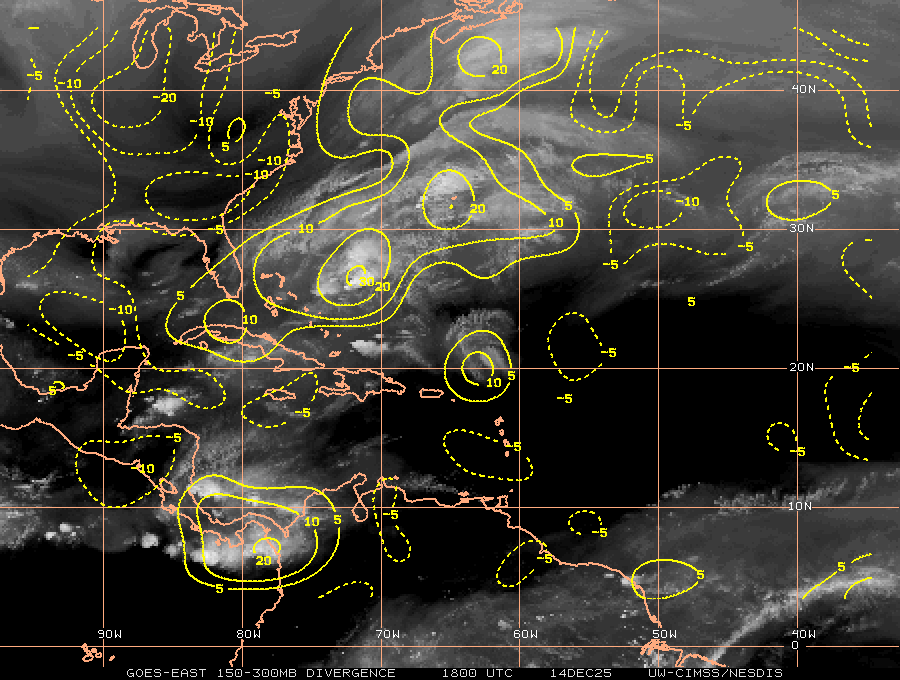
From what I´ve heard out taging stoms as invests might just mean they want to run a couple modles on the area, not necisarily that anyone thinks it has a high chance of forming. Personally I dont think it will be tagged, today atleast because it does not have much to work with at the moment, not much low convergence, ok upper divergence, little to no voticity, moderate shear, and not much model support. I dont think this will become 95l today.
I obtained my thoughts from viewing the cimss sight for winds and analisis.
The posts in this forum are NOT official forecast and should not be used as such. They are just the opinion of the poster and may or may not be backed by sound meteorological data. They are NOT endorsed by any professional institution or storm2k.org. For official information, please refer to the NHC and NWS products.
0 likes
I am just an amateur and a "noob" at that so any speculations that I have made are just that, uneducated speculations. Please refer to the NHC for accurate information.
Thank you all for your thoughts, I've loved reading through this community since '06 and finally decided to post more actively.
-JJ
Thank you all for your thoughts, I've loved reading through this community since '06 and finally decided to post more actively.
-JJ
-
Aric Dunn
- Category 5
- Posts: 21238
- Age: 43
- Joined: Sun Sep 19, 2004 9:58 pm
- Location: Ready for the Chase.
- Contact:
The other thing is. The area to watch would be the far western well rather NW Carrib. this area from alst night and today will move there and hang around. chances are not that great but yesterdays 12z runs from gfs nogaps and ukmet showed something weak.
0 likes
Note: If I make a post that is brief. Please refer back to previous posts for the analysis or reasoning. I do not re-write/qoute what my initial post said each time.
If there is nothing before... then just ask
Space & Atmospheric Physicist, Embry-Riddle Aeronautical University,
I believe the sky is falling...
If there is nothing before... then just ask
Space & Atmospheric Physicist, Embry-Riddle Aeronautical University,
I believe the sky is falling...
Re: Western Carribean
Crown Weather reports chances near zero for any development this week.....40 knot wind shear not conducive for development atm.....if the area persists into next week the area may need to be watched more closely...
0 likes
-
TropicalAnalystwx13

- Category 5
- Posts: 2109
- Age: 28
- Joined: Tue Jul 19, 2011 8:20 pm
- Location: Wilmington, NC
- Contact:
This area should not become anything of note. It's just an area of showers and thunderstorms being fueled by a divergent flow aloft. Surface observation and vorticity maps don't show any signs of a surface circulation, and the disturbance (if you want to call it that) is under high wind shear not at all conducive for organization.
0 likes
Who is online
Users browsing this forum: TeamPlayersBlue and 82 guests