ATL: BERYL - Post-Tropical
Moderator: S2k Moderators
-
TeamPlayersBlue

- Category 5

- Posts: 3529
- Joined: Tue Feb 02, 2010 1:44 am
- Location: Denver/Applewood, CO
Re: ATL: BERYL - Tropical Depression
Sanibel wrote:Good form considering it's land-bound.
Was thinking the same thing. The eastern quadrants of the storm are over water which is helping the storm pull in plenty of moisture.
0 likes
Personal Forecast Disclaimer:
The posts in this forum are NOT official forecast and should not be used as such. They are just the opinion of the poster and may or may not be backed by sound meteorological data. They are NOT endorsed by any professional institution or storm2k.org. For official information, please refer to the NHC and NWS products.
The posts in this forum are NOT official forecast and should not be used as such. They are just the opinion of the poster and may or may not be backed by sound meteorological data. They are NOT endorsed by any professional institution or storm2k.org. For official information, please refer to the NHC and NWS products.

Re: ATL: BERYL - Tropical Depression
Are we sure about the cold front picking up Beryl - sending her to N.E?
Kinda looks like front weak in south - may not lift her out?
Kinda looks like front weak in south - may not lift her out?
0 likes
-
wxman57

- Moderator-Pro Met

- Posts: 23172
- Age: 68
- Joined: Sat Jun 21, 2003 8:06 pm
- Location: Houston, TX (southwest)
Re: ATL: BERYL - Tropical Depression
crimi481 wrote:Are we sure about the cold front picking up Beryl - sending her to N.E?
Kinda looks like front weak in south - may not lift her out?
Beryl is already moving NE.
0 likes

Re: Re:
northjaxpro wrote:It turns out that I experienced the season's first landfalling tropical cyclone and the strongest ever in history during the month of May in the Atlantic basin. Amazing!
Beryl isn't the strongest tropical cyclone ever in history during the month of May in the Atlantic Basin. I believe that title goes to Hurricane Able.
0 likes
Re: ATL: BERYL - Tropical Depression


Should be some nice drought relief for NE Florida and extreme SE Georgia. Too bad the D4 areas in Georgia didn't pick up higher rainfall totals. Hopefully Georgia and South Carolina can pick up some more rain as Beryl exits northeastward.
0 likes
Re: ATL: BERYL - Tropical Depression
We got our rain, northwest of Jax, overnight, another 1.5 inches. Actually 4 inches within the last 24 hours.
Last edited by Peach on Tue May 29, 2012 12:08 pm, edited 1 time in total.
0 likes
-
northjaxpro

- S2K Supporter

- Posts: 8900
- Joined: Mon Sep 27, 2010 11:21 am
- Location: Jacksonville, FL
Re: Re:
ravyrn wrote:northjaxpro wrote:It turns out that I experienced the season's first landfalling tropical cyclone and the strongest ever in history during the month of May in the Atlantic basin. Amazing!
Beryl isn't the strongest tropical cyclone ever in history during the month of May in the Atlantic Basin. I believe that title goes to Hurricane Able.
Well, let me clarify my earlier statement. Beryl is the strongest month of May tropical cyclone to make landfall on the Continental U.S. from the Atlantic basin. Beryl takes that title away from the unnamed storm of 1908 and from Sub-Tropical Storm Alpha in 1972. Hurricane Able was the strongest tropical cyclone to form in the Atlantic basin, but it stayed out to sea.
Thanks for alerting me of that though regarding Able. That one slipped by me, but hey I am still kind of getting back to some normalcy after Beryl came through here Sunday night. It has been crazy around here the past 72 hours.
Last edited by northjaxpro on Tue May 29, 2012 12:42 pm, edited 1 time in total.
0 likes
NEVER, EVER SAY NEVER in the tropics and weather in general, and most importantly, with life itself!!
________________________________________________________________________________________
Fay 2008 Beryl 2012 Debby 2012 Colin 2016 Hermine 2016 Julia 2016 Matthew 2016 Irma 2017 Dorian 2019
________________________________________________________________________________________
Fay 2008 Beryl 2012 Debby 2012 Colin 2016 Hermine 2016 Julia 2016 Matthew 2016 Irma 2017 Dorian 2019
Re: ATL: BERYL - Tropical Depression
Is the stacked Mid Low de-coupling from the LLC? (Taking lots weather with itto N.E.?)
0 likes

Re: ATL: BERYL - Tropical Depression
ravyrn wrote:http://img140.imageshack.us/img140/80/berylrainfall5291540utc.jpghttp://img337.imageshack.us/img337/9108/sedrought52212.jpg
Should be some nice drought relief for NE Florida and extreme SE Georgia. Too bad the D4 areas in Georgia didn't pick up higher rainfall totals. Hopefully Georgia and South Carolina can pick up some more rain as Beryl exits northeastward.
finally got a good morning full of rain here in NW Orlando, looks like another good soaking this afternoon which we sorely need...think 99% of people will call this storm a huge blessing
0 likes
Just like Jon Snow..."I know nothing" except what I know, and most of what I know is gathered by the fine people of the NHC
-
tolakram
- Admin

- Posts: 20178
- Age: 62
- Joined: Sun Aug 27, 2006 8:23 pm
- Location: Florence, KY (name is Mark)
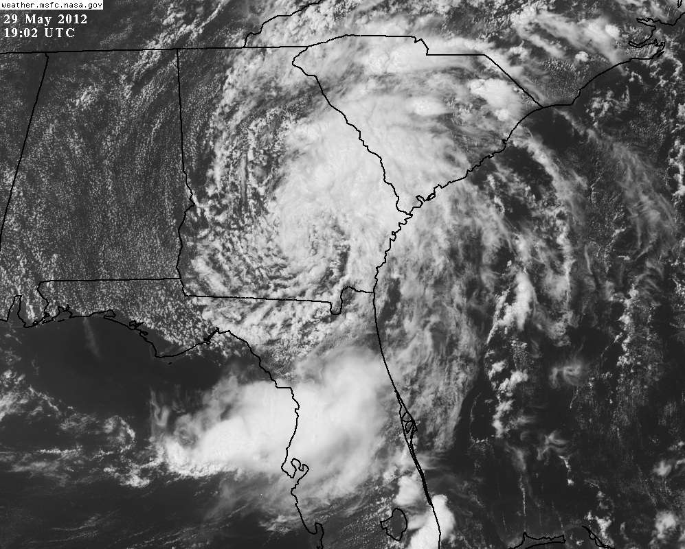
Re: ATL: BERYL - Tropical Depression
Very attractive afternoon shot:
Live loop, speed up for full effect: http://wwwghcc.msfc.nasa.gov/cgi-bin/ge ... mframes=15
Live loop, speed up for full effect: http://wwwghcc.msfc.nasa.gov/cgi-bin/ge ... mframes=15
0 likes
M a r k
- - - - -
Join us in chat: Storm2K Chatroom Invite. Android and IOS apps also available.
The posts in this forum are NOT official forecasts and should not be used as such. Posts are NOT endorsed by any professional institution or STORM2K.org. For official information and forecasts, please refer to NHC and NWS products.

Re: Re:
ravyrn wrote:northjaxpro wrote:It turns out that I experienced the season's first landfalling tropical cyclone and the strongest ever in history during the month of May in the Atlantic basin. Amazing!
Beryl isn't the strongest tropical cyclone ever in history during the month of May in the Atlantic Basin. I believe that title goes to Hurricane Able.
weather channel reported this morning that Beryl is the strongest TS
0 likes
CARTERET COUNTY NC
-
cycloneye

- Admin
- Posts: 149275
- Age: 69
- Joined: Thu Oct 10, 2002 10:54 am
- Location: San Juan, Puerto Rico
Re: ATL: BERYL - Advisories
BULLETIN
TROPICAL DEPRESSION BERYL ADVISORY NUMBER 16
NWS NATIONAL HURRICANE CENTER MIAMI FL AL022012
500 PM EDT TUE MAY 29 2012
...SLOW-MOVING BERYL PRODUCING HEAVY RAINS...
SUMMARY OF 500 PM EDT...2100 UTC...INFORMATION
----------------------------------------------
LOCATION...31.8N 82.5W
ABOUT 40 MI...60 KM N OF WAYCROSS GEORGIA
ABOUT 85 MI...135 KM WSW OF SAVANNAH GEORGIA
MAXIMUM SUSTAINED WINDS...30 MPH...45 KM/H
PRESENT MOVEMENT...NE OR 55 DEGREES AT 8 MPH...13 KM/H
MINIMUM CENTRAL PRESSURE...1005 MB...29.68 INCHES
WATCHES AND WARNINGS
--------------------
THERE ARE NO COASTAL WATCHES OR WARNINGS IN EFFECT.
DISCUSSION AND 48-HOUR OUTLOOK
------------------------------
AT 500 PM EDT...2100 UTC...THE CENTER OF TROPICAL DEPRESSION BERYL
WAS LOCATED NEAR LATITUDE 31.8 NORTH...LONGITUDE 82.5 WEST. THE
DEPRESSION IS NOW MOVING TOWARD THE NORTHEAST NEAR 8 MPH...13 KM/H.
A GRADUAL INCREASE IN FORWARD SPEED IS EXPECTED TO CONTINUE
TONIGHT...BRINGING THE CENTER OF BERYL CLOSE TO THE COAST OF SOUTH
CAROLINA BY EARLY WEDNESDAY AND BACK OVER ATLANTIC WATERS WEDNESDAY
AFTERNOON.
MAXIMUM SUSTAINED WINDS REMAIN NEAR 30 MPH...45 KM/H...WITH HIGHER
GUSTS. LITTLE CHANGE IN STRENGTH IS EXPECTED TONIGHT...BUT BERYL
COULD REGAIN TROPICAL STORM STATUS ON WEDNESDAY AS IT MOVES ALONG
THE COASTLINE.
ESTIMATED MINIMUM CENTRAL PRESSURE IS 1005 MB...29.68 INCHES.
HAZARDS AFFECTING LAND
----------------------
WIND...ISOLATED TROPICAL-STORM-FORCE WIND GUSTS ARE STILL POSSIBLE
OVER SOUTHEASTERN GEORGIA AND SOUTHERN SOUTH CAROLINA
TONIGHT...PARTICULARLY IN RAINBANDS.
SURF...DANGEROUS SURF CONDITIONS...INCLUDING RIP CURRENTS...ARE
STILL POSSIBLE ALONG THE COAST FROM NORTHEASTERN FLORIDA TO NORTH
CAROLINA TONIGHT. FOR INFORMATION SPECIFIC TO YOUR AREA...PLEASE SEE
STATEMENTS ISSUED BY YOUR LOCAL NATIONAL WEATHER SERVICE OFFICE.
RAINFALL...BERYL IS EXPECTED TO PRODUCE TOTAL RAIN ACCUMULATIONS OF
3 TO 6 INCHES...WITH ISOLATED MAXIMUM AMOUNTS OF 8 INCHES...IN
EASTERN SOUTH CAROLINA AND EASTERN NORTH CAROLINA. BERYL IS EXPECTED
TO PRODUCE ADDITIONAL RAINFALL AMOUNTS OF 1 TO 3 INCHES ACROSS
PORTIONS OF EASTERN GEORGIA AND NORTHERN FLORIDA...WITH ISOLATED
STORM TOTAL AMOUNTS OF 15 INCHES POSSIBLE.
TORNADOES...ISOLATED TORNADOES ARE POSSIBLE OVER EASTERN SOUTH
CAROLINA AND SOUTHEASTERN NORTH CAROLINA TONIGHT.
NEXT ADVISORY
-------------
NEXT COMPLETE ADVISORY...1100 PM EDT.
$$
FORECASTER AVILA
TROPICAL DEPRESSION BERYL DISCUSSION NUMBER 16
NWS NATIONAL HURRICANE CENTER MIAMI FL AL022012
500 PM EDT TUE MAY 29 2012
THERE HAS BEEN NO SIGNIFICANT CHANGE IN THE STRUCTURE OF THE
DEPRESSION DURING THE DAY. THE CIRCULATION REMAINS WELL
ESTABLISHED WITH MOST OF THE CONVECTION IN THE EASTERN SEMICIRCLE.
INITIAL INTENSITY IS HELD AT 25 KNOTS...BUT THESE WINDS ARE
OCCURRING PRIMARILY OVER WATER WITHIN RAINBANDS. NOT MUCH CHANGE IN
INTENSITY IS EXPECTED DURING THE NEXT 12 HOURS OR SO WHILE THE
CENTER IS OVER LAND. BERYL IS FORECAST TO REGAIN TROPICAL STORM
STRENGTH AS THE CIRCULATION MOVES OVER THE WARM WATERS OF THE GULF
STREAM BEYOND 24 HOURS. MOST OF THE GLOBAL MODELS CONTINUE TO IMPLY
THAT BERYL WILL BEGIN TO LOSE TROPICAL CHARACTERISTICS IN 48
HOURS...AND LATER BECOME ABSORBED BY A LARGER EXTRATROPICAL
CYCLONE. THIS IS INDICATED IN THE OFFICIAL FORECAST.
THE DEPRESSION IS MOVING A LITTLE FASTER TO THE NORTHEAST...OR 055
DEGREES AT 7 KNOTS. THE CYCLONE IS ALREADY EMBEDDED WITHIN THE
THE WESTERLIES AROUND THE BASE OF AN EASTWARD-MOVING SHORT WAVE
TROUGH CURRENTLY LOCATED OVER THE CENTRAL UNITED STATES. A GENERAL
NORTHEAST MOTION SHOULD CONTINUE FOR THE NEXT FEW DAYS WITH A
GRADUAL INCREASE IN FORWARD SPEED AS THE SHORT WAVE AMPLIFIES. THE
OFFICIAL FORECAST IS A LITTLE BIT SOUTH OF THE GUIDANCE ENVELOPE
AND LEANS TOWARD THE ECMWF WHICH IS THE SOUTHERNMOST SOLUTION.
ALTHOUGH THE OFFICIAL FORECAST SHOWS A TROPICAL STORM CENTERED VERY
NEAR THE NORTH CAROLINA COAST IN 24 HOURS...IT IS EXPECTED THAT
TROPICAL-STORM-FORCE WINDS WOULD BE CONFINED TO THE SOUTHEAST AND
OFFSHORE QUADRANT OF THE CYCLONE. AS A RESULT...NO COASTAL WATCHES
OR WARNINGS CURRENTLY SEEM NECESSARY.
FORECAST POSITIONS AND MAX WINDS
INIT 29/2100Z 31.8N 82.5W 25 KT 30 MPH...INLAND
12H 30/0600Z 32.8N 80.7W 25 KT 30 MPH...INLAND
24H 30/1800Z 34.2N 77.5W 35 KT 40 MPH...OVER WATER
36H 31/0600Z 36.0N 73.7W 40 KT 45 MPH
48H 31/1800Z 37.5N 69.0W 40 KT 45 MPH...POST-TROP/EXTRATROP
72H 01/1800Z 40.0N 56.0W 40 KT 45 MPH...POST-TROP/EXTRATROP
96H 02/1800Z...DISSIPATED
$$
FORECASTER AVILA
0 likes
Visit the Caribbean-Central America Weather Thread where you can find at first post web cams,radars
and observations from Caribbean basin members Click Here
and observations from Caribbean basin members Click Here
-
UpTheCreek

- Category 1

- Posts: 397
- Age: 62
- Joined: Tue Aug 31, 2004 5:28 pm
- Location: Vassalboro, Maine
Re: ATL: BERYL - Tropical Depression
Heading our way, Sandyb! It will be interesting if it picks up strength once again as predicted by NHC, that could give us some sound flooding. I'm just hoping for some decent rain!
0 likes
Re: ATL: BERYL - Tropical Depression
She gave Baker county, Fla. a much needed soaking, only minor wind damage.
0 likes
-
WilmingtonSandbar
- S2K Supporter
- Posts: 505
- Joined: Sun Aug 29, 2010 12:11 pm
- Location: Southport, NC
-
northjaxpro
- S2K Supporter
- Posts: 8900
- Joined: Mon Sep 27, 2010 11:21 am
- Location: Jacksonville, FL
A check of the rain gauge and from 7:30 this morning to now, I picked up an addition 1.25 inches in the feederbands that rotated over the region. As stands now the grand total of rain I have received here at my home is just under 8 inches since Sunday afternoon when the first outer bands from Beryl reached the Jax area.
Considering that before Beryl came through that most in NE FL were about 10 inches below the year to date average, this should most definitely put a huge dent into the severe drought that has plagued the reion since last September.
Considering that before Beryl came through that most in NE FL were about 10 inches below the year to date average, this should most definitely put a huge dent into the severe drought that has plagued the reion since last September.
0 likes
NEVER, EVER SAY NEVER in the tropics and weather in general, and most importantly, with life itself!!
________________________________________________________________________________________
Fay 2008 Beryl 2012 Debby 2012 Colin 2016 Hermine 2016 Julia 2016 Matthew 2016 Irma 2017 Dorian 2019
________________________________________________________________________________________
Fay 2008 Beryl 2012 Debby 2012 Colin 2016 Hermine 2016 Julia 2016 Matthew 2016 Irma 2017 Dorian 2019
-
UpTheCreek
- Category 1
- Posts: 397
- Age: 62
- Joined: Tue Aug 31, 2004 5:28 pm
- Location: Vassalboro, Maine
Re:
northjaxpro wrote:As stands now the grand total of rain I have received here at my home is just under 8 inches since Sunday afternoon when the first outer bands from Beryl reached the Jax area.
Wow, no kidding? That's a good bit of rain!
0 likes
-
WilmingtonSandbar
- S2K Supporter
- Posts: 505
- Joined: Sun Aug 29, 2010 12:11 pm
- Location: Southport, NC
It looks like at the rate it is moving, it is 2-3 hours away from the CoC reaching the ocean again. I wonder what the SSTs are and if shear is low enough for any re-intensification at all?
0 likes
Diana X2 (look it up), Bertha, Fran, Bonnie, Floyd, Dennis, Charley, Ophelia, Ernesto, Irene, Matthew, And Florence
Re:
northjaxpro wrote:A check of the rain gauge and from 7:30 this morning to now, I picked up an addition 1.25 inches in the feederbands that rotated over the region. As stands now the grand total of rain I have received here at my home is just under 8 inches since Sunday afternoon when the first outer bands from Beryl reached the Jax area.
Considering that before Beryl came through that most in NE FL were about 10 inches below the year to date average, this should most definitely put a huge dent into the severe drought that has plagued the reion since last September.
Wow...much needed, too.
Here in Savannah, my rain gauge says I've received a whopping 1/2 inch of rain since yesterday. And I've double checked it for leaks. Forecast was for 3-5 inches. I'm tellin' ya, some aspiring young grad student should come here and investigate what has to be some meteorological phenomenon in the atmosphere.
0 likes
Who is online
Users browsing this forum: No registered users and 27 guests