from melbourne office.
FRI-MON...FAIRLY SIGNIFICANT DIFFS BETWEEN THE 12Z GFS AND ECM
EMERGE IN THE XTD RANGE. THE GFS ROTATES ENERGY FROM A WRN ATLC
TROUGH SWD INTO FL...KEEPING A MID TO UPPER TROUGH AXIS OR LOW
CENTER OVER CTRL FL. THE ECM IS MORE PROGRESSIVE WITH THE WRN ATLC
TROUGH AND SHOWS H50 HEIGHTS ABOUT 30-50M HIGHER FROM SATURDAY
ONWARD. WHILE BOTH SHOW DEVELOPING MODERATE STRENGTH ONSHORE FLOW
REGIME THROUGH THE PERIOD...THE ECM IS BOTH DRIER SAT-SUN...AND
WEAKER WITH THE ONSHORE FLOW SUN-MON. LATEST GFS SOLUTION WOULD
PORTEND A MORE SHOWERY REGIME WITH LOWER END TS THREAT...WHILE THE
DRIER ECM FAVORS LOWER OVERALL COVERAGE AND LESS BREEZY CONDS.
DON`T WANT TO MAKE WHOLESALE XTD RANGE CHANGES YET WITH SUCH DIFFS
IN THE GUIDANCE. CURRENT FORECAST SHOWS SCATTERED POPS DURING THE
DAYTIME PERIODS AND ISOLD OVERNIGHT. SUBSEQUENT FCSTS WILL LIKELY
NEED TO TWEAK THE GRIDS TO DENOTE MORE OF COASTAL SHOWER THREAT
THAN AREAWIDE PRECIP FROM THIS WEEKEND.
key west
THIS WEEKEND...GUIDANCE INDICATES A SLOWLY SINKING AND VERY
POSITIVELY-TILTED UPPER TROUGH WORKING DOWN ALONG THE EASTERN
SEABOARD. THIS POSSIBLY DELAYS DEEP MOISTURE RETURN WITH UPPER FLOW
MORE WESTERLY THAN EARLIER ANTICIPATED. 40 POPS WERE PUSHED BACK TO
LATER IN THE WEEKEND AS THERE IS GREATER UNCERTAINTY IN GETTING DEEP
CARIBBEAN MOISTURE PULLED NORTH OF CUBA.
Global model runs discussion
Moderator: S2k Moderators
-
Aric Dunn
- Category 5

- Posts: 21238
- Age: 43
- Joined: Sun Sep 19, 2004 9:58 pm
- Location: Ready for the Chase.
- Contact:
0 likes
Note: If I make a post that is brief. Please refer back to previous posts for the analysis or reasoning. I do not re-write/qoute what my initial post said each time.
If there is nothing before... then just ask
Space & Atmospheric Physicist, Embry-Riddle Aeronautical University,
I believe the sky is falling...
If there is nothing before... then just ask
Space & Atmospheric Physicist, Embry-Riddle Aeronautical University,
I believe the sky is falling...

Re: Global Model Runs Discussion
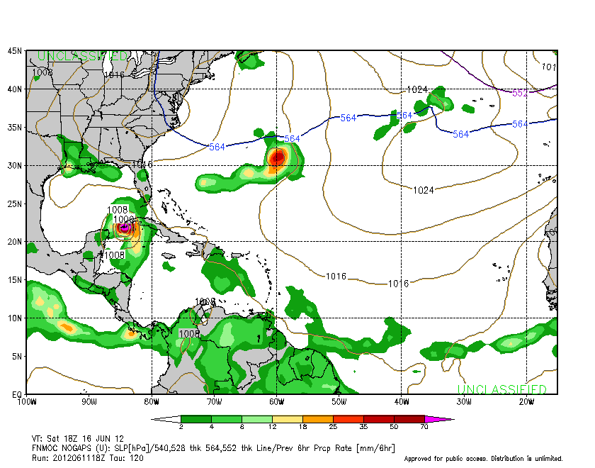
18z NOGAPS - tropical cyclone up the spine of FL peninsula.
https://www.fnmoc.navy.mil/wxmap_cgi/cgi-bin/wxmap_loop.cgi?&area=ngp_troplant&prod=z85&dtg=2012061118&set=Tropical
https://www.fnmoc.navy.mil/wxmap_cgi/cgi-bin/wxmap_loop.cgi?&area=ngp_troplant&prod=z85&dtg=2012061118&set=Tropical
0 likes
-
cycloneye

- Admin

- Posts: 149493
- Age: 69
- Joined: Thu Oct 10, 2002 10:54 am
- Location: San Juan, Puerto Rico
Re: Global Model Runs Discussion
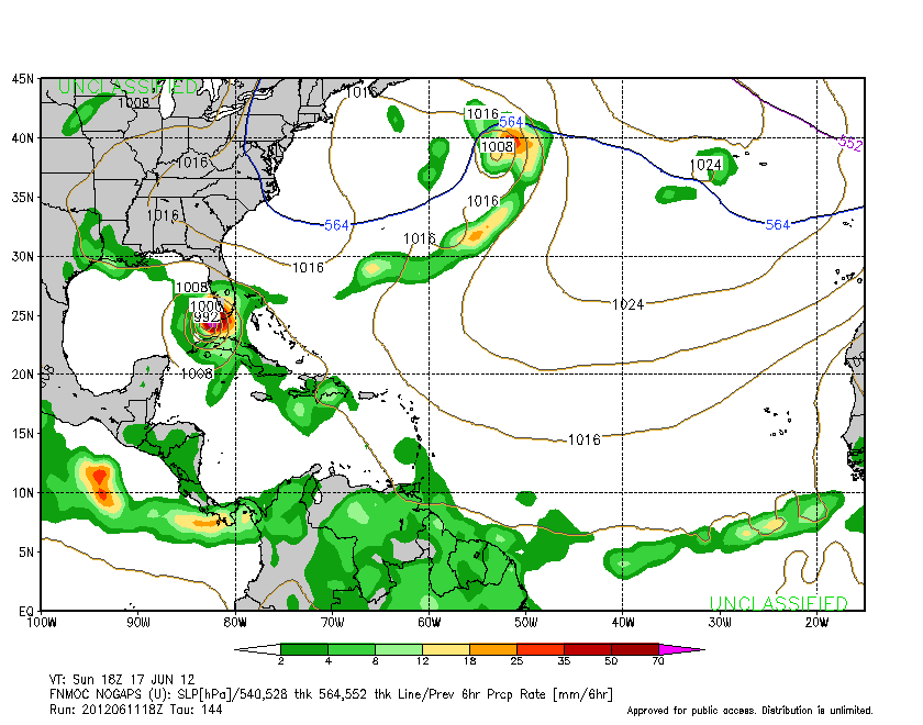
18z Nogaps continues to show the NW Caribbean system.
0 likes
Visit the Caribbean-Central America Weather Thread where you can find at first post web cams,radars
and observations from Caribbean basin members Click Here
and observations from Caribbean basin members Click Here
-
Aric Dunn
- Category 5
- Posts: 21238
- Age: 43
- Joined: Sun Sep 19, 2004 9:58 pm
- Location: Ready for the Chase.
- Contact:
the nogaps is interesting. it starts to develop the epac system then a wave from the central carrib moves into the western carrib and develops. well looking at TPW there is a wave or at least a surge of energy moving through the central carrib right now. The timing of that energy to the western carrib is about 24 to 30 hours and at least on TPW seems to be a inverted trough to it. once that gets to the western carrib convection should begin to develop as the environment is more conducive for convection. going to be interesting to see how it pans out.

0 likes
Note: If I make a post that is brief. Please refer back to previous posts for the analysis or reasoning. I do not re-write/qoute what my initial post said each time.
If there is nothing before... then just ask
Space & Atmospheric Physicist, Embry-Riddle Aeronautical University,
I believe the sky is falling...
If there is nothing before... then just ask
Space & Atmospheric Physicist, Embry-Riddle Aeronautical University,
I believe the sky is falling...
-
thundercam96

- Tropical Storm

- Posts: 129
- Joined: Thu Aug 18, 2011 3:01 pm
- Location: Boston, MA
Re: Global Model Runs Discussion
ronjon wrote:18z NOGAPS - tropical cyclone up the spine of FL peninsula.
https://www.fnmoc.navy.mil/wxmap_cgi/cgi-bin/wxmap_loop.cgi?&area=ngp_troplant&prod=z85&dtg=2012061118&set=Tropical
0 likes
Fay '08 / Mathew 16'
Personal Forecast Disclaimer: I am not a certified meteorologist, therefore, what is posted on this forum under my header should not be treated as an official forecast. Please refer to the NWS/NHC products for forecast information.
Personal Forecast Disclaimer: I am not a certified meteorologist, therefore, what is posted on this forum under my header should not be treated as an official forecast. Please refer to the NWS/NHC products for forecast information.
Re: Global Model Runs Discussion
Actually it looks to me that genesis occurs in the NOGAPS (and remember this is the dreadful Navy model) from existing convection near Panama that is boosted by a disturbance coming off SA. Already see how things might come together on SAT.
http://www.ssd.noaa.gov/goes/east/watl/flash-avn.html
http://www.ssd.noaa.gov/goes/east/watl/flash-avn.html
0 likes
-
wxman57

- Moderator-Pro Met

- Posts: 23175
- Age: 68
- Joined: Sat Jun 21, 2003 8:06 pm
- Location: Houston, TX (southwest)
Re: Global Model Runs Discussion
The story so far - various models develop anything from a weak wave of tropical moisture to a hurricane somewhere between the western Caribbean, East Pac then moving north into the BoC, Gulf of Mexico, or the East Coast between the dates of Sunday, June 17th and Friday, June 22nd. That about it?
Yes, all the models are picking up on "something" happening next week. But what, where and when? Currently the trend is to push development later into next week. Earlier, they were focusing on Sat/Sun, then Sun/Mon, now Mon/Tue and later. Always in the long range. The key will be to watch to see if there is any moisture increase in the western Caribbean or the East Pac extending north into the BoC by this weekend. If thunderstorms begin popping in the region, then we'll know that the models have been on to something. I'd say at the very least that the model support for development puts development chances above the climatological norm for a storm in the Gulf the 3rd week of June (I think climo is in the 3-4% range). And if we do see the predicted significant increase in moisture/tstms in the region this weekend, then chances are significantly higher for development.
Yes, all the models are picking up on "something" happening next week. But what, where and when? Currently the trend is to push development later into next week. Earlier, they were focusing on Sat/Sun, then Sun/Mon, now Mon/Tue and later. Always in the long range. The key will be to watch to see if there is any moisture increase in the western Caribbean or the East Pac extending north into the BoC by this weekend. If thunderstorms begin popping in the region, then we'll know that the models have been on to something. I'd say at the very least that the model support for development puts development chances above the climatological norm for a storm in the Gulf the 3rd week of June (I think climo is in the 3-4% range). And if we do see the predicted significant increase in moisture/tstms in the region this weekend, then chances are significantly higher for development.
0 likes
-
Dean4Storms
- S2K Supporter

- Posts: 6358
- Age: 63
- Joined: Sun Aug 31, 2003 1:01 pm
- Location: Miramar Bch. FL
Re: Global Model Runs Discussion
wxman57 wrote:The story so far - various models develop anything from a weak wave of tropical moisture to a hurricane somewhere between the western Caribbean, East Pac then moving north into the BoC, Gulf of Mexico, or the East Coast between the dates of Sunday, June 17th and Friday, June 22nd. That about it?
Yes, all the models are picking up on "something" happening next week. But what, where and when? Currently the trend is to push development later into next week. Earlier, they were focusing on Sat/Sun, then Sun/Mon, now Mon/Tue and later. Always in the long range. The key will be to watch to see if there is any moisture increase in the western Caribbean or the East Pac extending north into the BoC by this weekend. If thunderstorms begin popping in the region, then we'll know that the models have been on to something. I'd say at the very least that the model support for development puts development chances above the climatological norm for a storm in the Gulf the 3rd week of June (I think climo is in the 3-4% range). And if we do see the predicted significant increase in moisture/tstms in the region this weekend, then chances are significantly higher for development.
I believe the MJO is expected to arrive for the weekend so an increase in moisture/convection should be favorable.
0 likes
-
Aric Dunn
- Category 5
- Posts: 21238
- Age: 43
- Joined: Sun Sep 19, 2004 9:58 pm
- Location: Ready for the Chase.
- Contact:
Re: Global Model Runs Discussion
wxman57 wrote:The story so far - various models develop anything from a weak wave of tropical moisture to a hurricane somewhere between the western Caribbean, East Pac then moving north into the BoC, Gulf of Mexico, or the East Coast between the dates of Sunday, June 17th and Friday, June 22nd. That about it?
Yes, all the models are picking up on "something" happening next week. But what, where and when? Currently the trend is to push development later into next week. Earlier, they were focusing on Sat/Sun, then Sun/Mon, now Mon/Tue and later. Always in the long range. The key will be to watch to see if there is any moisture increase in the western Caribbean or the East Pac extending north into the BoC by this weekend. If thunderstorms begin popping in the region, then we'll know that the models have been on to something. I'd say at the very least that the model support for development puts development chances above the climatological norm for a storm in the Gulf the 3rd week of June (I think climo is in the 3-4% range). And if we do see the predicted significant increase in moisture/tstms in the region this weekend, then chances are significantly higher for development.
Thats about it.. just have to wait. still interesting to analyze each run to see what its developing.
0 likes
Note: If I make a post that is brief. Please refer back to previous posts for the analysis or reasoning. I do not re-write/qoute what my initial post said each time.
If there is nothing before... then just ask
Space & Atmospheric Physicist, Embry-Riddle Aeronautical University,
I believe the sky is falling...
If there is nothing before... then just ask
Space & Atmospheric Physicist, Embry-Riddle Aeronautical University,
I believe the sky is falling...
-
cycloneye
- Admin
- Posts: 149493
- Age: 69
- Joined: Thu Oct 10, 2002 10:54 am
- Location: San Juan, Puerto Rico
Re: Global Model Runs Discussion
I have a question for 57 or Aric. Do you think that the models are having problems with the strong MJO pulse comming and that is why we see wacky runs going on?
0 likes
Visit the Caribbean-Central America Weather Thread where you can find at first post web cams,radars
and observations from Caribbean basin members Click Here
and observations from Caribbean basin members Click Here
-
Aric Dunn
- Category 5
- Posts: 21238
- Age: 43
- Joined: Sun Sep 19, 2004 9:58 pm
- Location: Ready for the Chase.
- Contact:
Re: Global Model Runs Discussion
cycloneye wrote:I have a question for 57 or Aric. Do you think that the models are having problems with the strong MJO pulse comming and that is why we see wacky runs going on?
well from what I know ( sure he knows more about it.) they can have a tendency to over or under estimate the amount of added lift from the MJO ( how much each model incorporates such data Im not sure) but I believe its more of land interaction that the models are having and issue. the gfs is over water in the western carrib almost the whole time ( disregarding strength from the GFS) vs. the euro which clearly has the majority of the energy over central america. now if they are having a hard time dealing with the MJO I would imagine it would be the timing of its arrival ( hence the later and later development.) compared to how the environment is at the time of the mjo energy. to late and upper winds are not conducive to early the same. nogaps has quick development has upper ridging is in place over the western carrib while the gfs and euro are very slow on development and go through a couple cycles of favorable environment but do to land interaction and other factors hold off development. just going to have to wait for something to actually take shape. i.e convection needs to develop in the carrib. Which could come as early as tomorrow as that impulse moves into the western carrib.
0 likes
Note: If I make a post that is brief. Please refer back to previous posts for the analysis or reasoning. I do not re-write/qoute what my initial post said each time.
If there is nothing before... then just ask
Space & Atmospheric Physicist, Embry-Riddle Aeronautical University,
I believe the sky is falling...
If there is nothing before... then just ask
Space & Atmospheric Physicist, Embry-Riddle Aeronautical University,
I believe the sky is falling...

Re: Global Model Runs Discussion
wxman57 wrote:The story so far - various models develop anything from a weak wave of tropical moisture to a hurricane somewhere between the western Caribbean, East Pac then moving north into the BoC, Gulf of Mexico, or the East Coast between the dates of Sunday, June 17th and Friday, June 22nd. That about it?
Yes, all the models are picking up on "something" happening next week. But what, where and when? Currently the trend is to push development later into next week. Earlier, they were focusing on Sat/Sun, then Sun/Mon, now Mon/Tue and later. Always in the long range. The key will be to watch to see if there is any moisture increase in the western Caribbean or the East Pac extending north into the BoC by this weekend. If thunderstorms begin popping in the region, then we'll know that the models have been on to something. I'd say at the very least that the model support for development puts development chances above the climatological norm for a storm in the Gulf the 3rd week of June (I think climo is in the 3-4% range). And if we do see the predicted significant increase in moisture/tstms in the region this weekend, then chances are significantly higher for development.
Hopefully we get rain out of it.
0 likes
Re: Global Model Runs Discussion
It has the "feel" down here right now but my gut says no system.
0 likes

Re: Global Model Runs Discussion
Sanibel wrote:It has the "feel" down here right now but my gut says no system.
I share my feelings its really clear down there and the flow is east to west which would push everything into Central America and inot the Pacific.Last week the flow was SW which brought everything from the Pacific and Caribbean Northward my 2 cents
0 likes

Re: Global Model Runs Discussion
the GFS runs shortly...along with the NOGAPS....the suspense is killing me... 
0 likes
-
floridasun78
- Category 5
- Posts: 3755
- Joined: Sun May 17, 2009 10:16 pm
- Location: miami fl
Re: Global Model Runs Discussion
0Z GFS has just lower pressures in the carib....the 0Z NOGAPS wants to do its FL thing....
0 likes
-
South Texas Storms

- Professional-Met

- Posts: 4259
- Joined: Thu Jun 24, 2010 12:28 am
- Location: Houston, TX
Re: Global Model Runs Discussion
The 0z CMC is back to showing a tropical storm in the western GOM in 10 days.

Uploaded with ImageShack.us

Uploaded with ImageShack.us
0 likes

GFS and Euro are still not very consistent at all of a well organized area of low pressure developing in timing, an exact area & its track, they have been all over the place.
The best thing to do is to wait as we get closer in time and wait for moisture to build up and hopefully the models can become more consistent.
The retrograding positive tilted UL trough of low pressure that will be positioning near the SE US coast by the weekend will help with divergence but it will not give the best UL environment as far as shear.
0 likes
Re: Global Model Runs Discussion
06z NOGAPS = tropical cyclone in the eastern GOM.
https://www.fnmoc.navy.mil/wxmap_cgi/cgi-bin/wxmap_loop.cgi?area=ngp_troplant&dtg=2012061206&prod=prp&tau=000&set=Tropical
https://www.fnmoc.navy.mil/wxmap_cgi/cgi-bin/wxmap_loop.cgi?area=ngp_troplant&dtg=2012061206&prod=prp&tau=000&set=Tropical
0 likes
Who is online
Users browsing this forum: No registered users and 45 guests