
https://www.fnmoc.navy.mil/wxmap_cgi/cg ... t=Tropical
Global model runs discussion
Moderator: S2k Moderators
Re: Global Model Runs Discussion
0 likes
Re: Global Model Runs Discussion
0 likes
-
Rgv20

- S2K Supporter

- Posts: 2466
- Age: 39
- Joined: Wed Jan 05, 2011 5:42 pm
- Location: Edinburg/McAllen Tx
0zGFS has a Tropical System heading into Florida in about 9 to 10 days from now..
0 likes
The following post is NOT an official forecast and should not be used as such. It is just the opinion of the poster and may or may not be backed by sound meteorological data. It is NOT endorsed by any professional institution including storm2k.org For Official Information please refer to the NHC and NWS products.
-
Rgv20
- S2K Supporter
- Posts: 2466
- Age: 39
- Joined: Wed Jan 05, 2011 5:42 pm
- Location: Edinburg/McAllen Tx
Possible tropical development aside it is looking fairly likely that some of our friends in Central America are going to deal with some torrential rainfall in the next 8 to 10 days.
0zGFS forecast Rainfall totals thru Wednesday Evening (June 20)

0zGFS forecast Rainfall totals thru Wednesday Evening (June 20)
0 likes
The following post is NOT an official forecast and should not be used as such. It is just the opinion of the poster and may or may not be backed by sound meteorological data. It is NOT endorsed by any professional institution including storm2k.org For Official Information please refer to the NHC and NWS products.
-
somethingfunny

- ChatStaff

- Posts: 3926
- Age: 37
- Joined: Thu May 31, 2007 10:30 pm
- Location: McKinney, Texas


-
Rgv20
- S2K Supporter
- Posts: 2466
- Age: 39
- Joined: Wed Jan 05, 2011 5:42 pm
- Location: Edinburg/McAllen Tx
0zNogaps has the same idea as the 0zGFS but its a couple of days faster with regards to a TC hitting Florida.
0zNogaps forecast valid Wed morning June 20.

0zNogaps forecast valid Wed morning June 20.
0 likes
The following post is NOT an official forecast and should not be used as such. It is just the opinion of the poster and may or may not be backed by sound meteorological data. It is NOT endorsed by any professional institution including storm2k.org For Official Information please refer to the NHC and NWS products.
-
somethingfunny
- ChatStaff
- Posts: 3926
- Age: 37
- Joined: Thu May 31, 2007 10:30 pm
- Location: McKinney, Texas
I suggest everybody here watching the potential for Chris ought to be following Invest 94E in the EPAC, as its' evolution will have a huge impact on how things play out in the Caribbean:
viewtopic.php?p=2228854#p2228854
viewtopic.php?p=2228854#p2228854
0 likes
I am not a meteorologist, and any posts made by me are not official forecasts or to be interpreted as being intelligent. These posts are just my opinions and are probably silly opinions.
-
South Texas Storms

- Professional-Met

- Posts: 4258
- Joined: Thu Jun 24, 2010 12:28 am
- Location: Houston, TX

-
SETXWXLADY
- Tropical Storm

- Posts: 216
- Joined: Wed May 20, 2009 3:26 pm
- Location: SE TX Orange County


A little better model concensus last night among the models.
NOGAPS and GFS showing development faster than the ECMWF and CMC.
Personally I think NOGAPS and GFS are too fast.
I can say with a little better confidence this morning that tropical development has gotten a little higher in chances for next Tuesday-Wednesday time frame in the NW Caribbean, IMO.
The posts in this forum are NOT official forecast and should not be used as such. They are just the opinion of the poster and may or may not be backed by sound meteorological data. They are NOT endorsed by any professional institution or storm2k.org. For official information, please refer to the NHC and NWS products
0 likes
-
cycloneye

- Admin

- Posts: 149489
- Age: 69
- Joined: Thu Oct 10, 2002 10:54 am
- Location: San Juan, Puerto Rico
Re:
somethingfunny wrote:I suggest everybody here watching the potential for Chris ought to be following Invest 94E in the EPAC, as its' evolution will have a huge impact on how things play out in the Caribbean:
viewtopic.php?p=2228854#p2228854
I agree 100%. Crossover or not,it will be a big player down the road.
0 likes
Visit the Caribbean-Central America Weather Thread where you can find at first post web cams,radars
and observations from Caribbean basin members Click Here
and observations from Caribbean basin members Click Here

Re: Global Model Runs Discussion
last GFS run closer to CMC and king Euro. Takes it to central GOM then shoots off to the east-northeast,

0 likes
The following post is NOT an official forecast and should not be used as such. It is just the opinion of the poster and may or may not be backed by sound meteorological data. It is NOT endorsed by any professional institution including storm2k.org For Official Information please refer to the NHC and NWS products.
-
Aric Dunn
- Category 5

- Posts: 21238
- Age: 43
- Joined: Sun Sep 19, 2004 9:58 pm
- Location: Ready for the Chase.
- Contact:
Re: Re:
cycloneye wrote:somethingfunny wrote:I suggest everybody here watching the potential for Chris ought to be following Invest 94E in the EPAC, as its' evolution will have a huge impact on how things play out in the Caribbean:
viewtopic.php?p=2228854#p2228854
I agree 100%. Crossover or not,it will be a big player down the road.
yeah mentioned its couple days ago that it would depend on what happened with the east pac system. besides the cross over the outflow from the east pac system will help enhance convection in the western carrib especially later today once the wave axis reaches the western carrib. we shall see.
0 likes
Note: If I make a post that is brief. Please refer back to previous posts for the analysis or reasoning. I do not re-write/qoute what my initial post said each time.
If there is nothing before... then just ask
Space & Atmospheric Physicist, Embry-Riddle Aeronautical University,
I believe the sky is falling...
If there is nothing before... then just ask
Space & Atmospheric Physicist, Embry-Riddle Aeronautical University,
I believe the sky is falling...
-
Aric Dunn
- Category 5
- Posts: 21238
- Age: 43
- Joined: Sun Sep 19, 2004 9:58 pm
- Location: Ready for the Chase.
- Contact:
Re:
NDG wrote:A little better model concensus last night among the models.
NOGAPS and GFS showing development faster than the ECMWF and CMC.
Personally I think NOGAPS and GFS are too fast.
I can say with a little better confidence this morning that tropical development has gotten a little higher in chances for next Tuesday-Wednesday time frame in the NW Caribbean, IMO.
The posts in this forum are NOT official forecast and should not be used as such. They are just the opinion of the poster and may or may not be backed by sound meteorological data. They are NOT endorsed by any professional institution or storm2k.org. For official information, please refer to the NHC and NWS products
yeah for sure. and the gfs is finally not keeping the system stuck then stretching it out. a sign the model is getting better handle on it. likely because the east pac system is much better organized and likely to develop which lessens the variables.
0 likes
Note: If I make a post that is brief. Please refer back to previous posts for the analysis or reasoning. I do not re-write/qoute what my initial post said each time.
If there is nothing before... then just ask
Space & Atmospheric Physicist, Embry-Riddle Aeronautical University,
I believe the sky is falling...
If there is nothing before... then just ask
Space & Atmospheric Physicist, Embry-Riddle Aeronautical University,
I believe the sky is falling...
-
cycloneye
- Admin
- Posts: 149489
- Age: 69
- Joined: Thu Oct 10, 2002 10:54 am
- Location: San Juan, Puerto Rico
Re: Re:
Aric Dunn wrote:NDG wrote:A little better model concensus last night among the models.
NOGAPS and GFS showing development faster than the ECMWF and CMC.
Personally I think NOGAPS and GFS are too fast.
I can say with a little better confidence this morning that tropical development has gotten a little higher in chances for next Tuesday-Wednesday time frame in the NW Caribbean, IMO.
The posts in this forum are NOT official forecast and should not be used as such. They are just the opinion of the poster and may or may not be backed by sound meteorological data. They are NOT endorsed by any professional institution or storm2k.org. For official information, please refer to the NHC and NWS products
yeah for sure. and the gfs is finally not keeping the system stuck then stretching it out. a sign the model is getting better handle on it. likely because the east pac system is much better organized and likely to develop which lessens the variables.
That EPAC 94E is ramping up quickly this morning. Models will have a much better handle once this develops.
viewtopic.php?f=59&t=112886&p=2228887#p2228887
0 likes
Visit the Caribbean-Central America Weather Thread where you can find at first post web cams,radars
and observations from Caribbean basin members Click Here
and observations from Caribbean basin members Click Here
-
Aric Dunn
- Category 5
- Posts: 21238
- Age: 43
- Joined: Sun Sep 19, 2004 9:58 pm
- Location: Ready for the Chase.
- Contact:
well for whats its worth. the low has moved off the SC coast this morning as well as the one off the mid atlantic. Also the low over extreme southern Mississippi and Alabama is going to heading over the gulf later ( this is the one the euro had yesterday in the gulf). do any of them transition is question. probably start a thread at some point for which one looks like it might do something.
0 likes
Note: If I make a post that is brief. Please refer back to previous posts for the analysis or reasoning. I do not re-write/qoute what my initial post said each time.
If there is nothing before... then just ask
Space & Atmospheric Physicist, Embry-Riddle Aeronautical University,
I believe the sky is falling...
If there is nothing before... then just ask
Space & Atmospheric Physicist, Embry-Riddle Aeronautical University,
I believe the sky is falling...
-
Rgv20
- S2K Supporter
- Posts: 2466
- Age: 39
- Joined: Wed Jan 05, 2011 5:42 pm
- Location: Edinburg/McAllen Tx
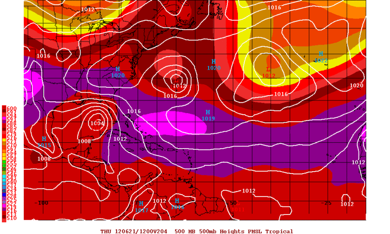
Well its going to be an interesting week ahead.
0zECMWF forecast valid for Thursday Evening June 21.
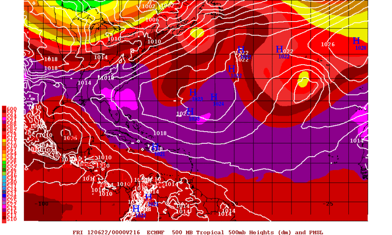
0zECMWF forecast valid for Thursday Evening June 21.
0 likes
The following post is NOT an official forecast and should not be used as such. It is just the opinion of the poster and may or may not be backed by sound meteorological data. It is NOT endorsed by any professional institution including storm2k.org For Official Information please refer to the NHC and NWS products.
Re: Global Model Runs Discussion
Yes, definitely something late in the long term model runs so we'll see...
Funny that a couple of months ago everyone (except NOAA) was saying "below average" for this season but now CSU has changed their mind - as Mike Seaver used to say (Growing Pains), "They don't have a clue"...
Sometimes I think God allows this just to show who's really in charge - it ain't (isn't) us...
Frank
0 likes
Who is online
Users browsing this forum: No registered users and 75 guests