Global model runs discussion
Moderator: S2k Moderators
-
floridasun78
- Category 5

- Posts: 3755
- Joined: Sun May 17, 2009 10:16 pm
- Location: miami fl
-
wxman57

- Moderator-Pro Met

- Posts: 23174
- Age: 68
- Joined: Sat Jun 21, 2003 8:06 pm
- Location: Houston, TX (southwest)
Re: Global Model Runs Discussion
Nothing new today. Models still all over the place but still generally indicating low pressure in the western Caribbean/Gulf next Tue-Fri. Should see thunderstorms increasing in the region by late this weekend. Perhaps an invest by next Mon. Until then, I don't expect much to happen.
0 likes
-
Aric Dunn
- Category 5
- Posts: 21238
- Age: 43
- Joined: Sun Sep 19, 2004 9:58 pm
- Location: Ready for the Chase.
- Contact:
Start watching that burst of convection east of Honduras overnight. there is a lot of vorticity in the area.
0 likes
Note: If I make a post that is brief. Please refer back to previous posts for the analysis or reasoning. I do not re-write/qoute what my initial post said each time.
If there is nothing before... then just ask
Space & Atmospheric Physicist, Embry-Riddle Aeronautical University,
I believe the sky is falling...
If there is nothing before... then just ask
Space & Atmospheric Physicist, Embry-Riddle Aeronautical University,
I believe the sky is falling...
-
Riptide

- Category 2

- Posts: 753
- Age: 34
- Joined: Fri Jul 23, 2010 3:33 pm
- Location: Cape May, New Jersey
- Contact:
Re: Global Model Runs Discussion
As previously mentioned, perhaps the only action in town this week is the Atlantic low.
0 likes
-
floridasun78
- Category 5
- Posts: 3755
- Joined: Sun May 17, 2009 10:16 pm
- Location: miami fl
Re:
Aric Dunn wrote:Start watching that burst of convection east of Honduras overnight. there is a lot of vorticity in the area.
i see that over Nicaragua their spin look like moving toward north or northwest
0 likes
-
Aric Dunn
- Category 5
- Posts: 21238
- Age: 43
- Joined: Sun Sep 19, 2004 9:58 pm
- Location: Ready for the Chase.
- Contact:
Re: Re:
floridasun78 wrote:Aric Dunn wrote:Start watching that burst of convection east of Honduras overnight. there is a lot of vorticity in the area.
i see that over Nicaragua their spin look like moving toward north or northwest
no east of honduras its nothing now. just convection. but watch it.
0 likes
Note: If I make a post that is brief. Please refer back to previous posts for the analysis or reasoning. I do not re-write/qoute what my initial post said each time.
If there is nothing before... then just ask
Space & Atmospheric Physicist, Embry-Riddle Aeronautical University,
I believe the sky is falling...
If there is nothing before... then just ask
Space & Atmospheric Physicist, Embry-Riddle Aeronautical University,
I believe the sky is falling...

Re:
Aric Dunn wrote:Start watching that burst of convection east of Honduras overnight. there is a lot of vorticity in the area.
Hmm, the vorticity that I see is over land, traveling across Nicaragua tonight.
0 likes
-
Aric Dunn
- Category 5
- Posts: 21238
- Age: 43
- Joined: Sun Sep 19, 2004 9:58 pm
- Location: Ready for the Chase.
- Contact:
Re: Re:
NDG wrote:Aric Dunn wrote:Start watching that burst of convection east of Honduras overnight. there is a lot of vorticity in the area.
Hmm, the vorticity that I see is over land, traveling across Nicaragua tonight.
yeah those maps are not as minute to minute... there is a tropical eave right there and an increase in convection is a sign convergence is increasing and rotation would be soon to follow. just seen very similar situations like this over the years. I have mentioned a few times the last couple days the outflow from the epac system will enhance convection in the carrib and that area would the are to watch. it will continue to move NW and from the looks of will stay over water. just think it will be the start of a slow process.
0 likes
Note: If I make a post that is brief. Please refer back to previous posts for the analysis or reasoning. I do not re-write/qoute what my initial post said each time.
If there is nothing before... then just ask
Space & Atmospheric Physicist, Embry-Riddle Aeronautical University,
I believe the sky is falling...
If there is nothing before... then just ask
Space & Atmospheric Physicist, Embry-Riddle Aeronautical University,
I believe the sky is falling...
-
floridasun78
- Category 5
- Posts: 3755
- Joined: Sun May 17, 2009 10:16 pm
- Location: miami fl
Re: Re:
NDG wrote:Aric Dunn wrote:Start watching that burst of convection east of Honduras overnight. there is a lot of vorticity in the area.
Hmm, the vorticity that I see is over land, traveling across Nicaragua tonight.
spin over lake Nicaragua
0 likes
Re: Re:
Aric Dunn wrote:NDG wrote:Aric Dunn wrote:Start watching that burst of convection east of Honduras overnight. there is a lot of vorticity in the area.
Hmm, the vorticity that I see is over land, traveling across Nicaragua tonight.
yeah those maps are not as minute to minute... there is a tropical eave right there and an increase in convection is a sign convergence is increasing and rotation would be soon to follow. just seen very similar situations like this over the years. I have mentioned a few times the last couple days the outflow from the epac system will enhance convection in the carrib and that area would the are to watch. it will continue to move NW and from the looks of will stay over water. just think it will be the start of a slow process.
Increase of convection this evening is due to UL Divergence, nothing but easterly winds all across the western Caribbean, for now.
0 likes
-
HouTXmetro

- Category 5
- Posts: 3949
- Joined: Sun Jun 13, 2004 6:00 pm
- Location: District of Columbia, USA
Re: Global Model Runs Discussion
Nothing new on the models tonight?
0 likes
[Disclaimer: My Amateur Opinion, please defer to your local authorities or the NHC for Guidance.]
-
floridasun78
- Category 5
- Posts: 3755
- Joined: Sun May 17, 2009 10:16 pm
- Location: miami fl
Re: Global Model Runs Discussion
HouTXmetro wrote:Nothing new on the models tonight?
new runs start coming out soon from now untill 3am my time that is est
0 likes
-
Rgv20

- S2K Supporter

- Posts: 2466
- Age: 39
- Joined: Wed Jan 05, 2011 5:42 pm
- Location: Edinburg/McAllen Tx
Thru 204hrs the 0zGFS is surprisingly similar to the previous run of the 12zGFS with the placement of a TC in the Western Gulf.
0zGFS Forecast valid for Friday Morning June 22....Its a tad further south than this morning 12z run.
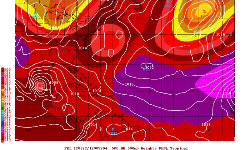
0zGFS Forecast valid for Friday Morning June 22....Its a tad further south than this morning 12z run.
0 likes
The following post is NOT an official forecast and should not be used as such. It is just the opinion of the poster and may or may not be backed by sound meteorological data. It is NOT endorsed by any professional institution including storm2k.org For Official Information please refer to the NHC and NWS products.
-
Rgv20
- S2K Supporter
- Posts: 2466
- Age: 39
- Joined: Wed Jan 05, 2011 5:42 pm
- Location: Edinburg/McAllen Tx
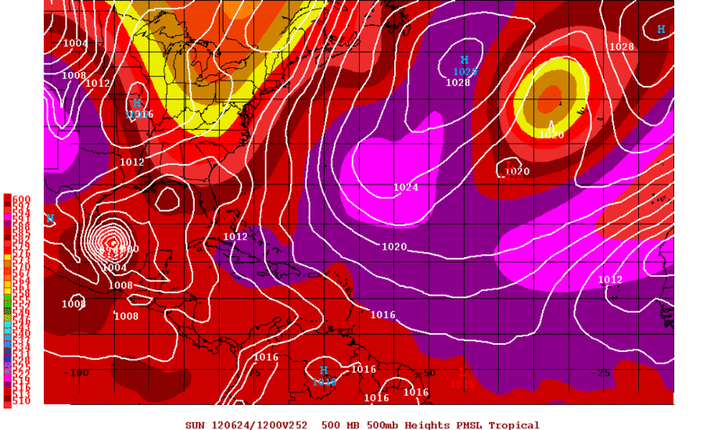
0zGFS Stalls the TC for over 2 days! 
0 likes
The following post is NOT an official forecast and should not be used as such. It is just the opinion of the poster and may or may not be backed by sound meteorological data. It is NOT endorsed by any professional institution including storm2k.org For Official Information please refer to the NHC and NWS products.
-
Rgv20
- S2K Supporter
- Posts: 2466
- Age: 39
- Joined: Wed Jan 05, 2011 5:42 pm
- Location: Edinburg/McAllen Tx
Even the 0zNogaps hinting at a possible TC in the BOC/Western GOM as we head to the middle/late next week.
0zNogaps Forecast Valid for Thursday Morning June 21....It has a weak area of low pressure in the Western GOM/BOC.
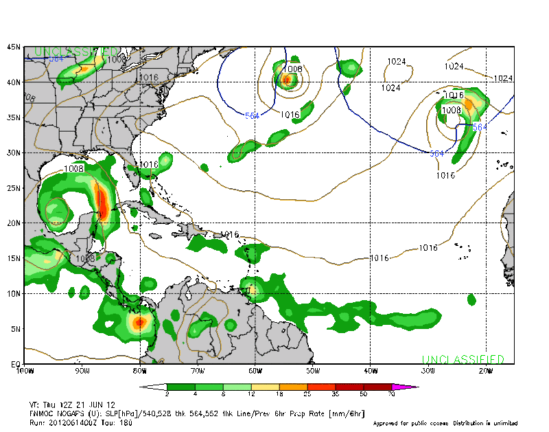
0zNogaps Forecast Valid for Thursday Morning June 21....It has a weak area of low pressure in the Western GOM/BOC.
0 likes
The following post is NOT an official forecast and should not be used as such. It is just the opinion of the poster and may or may not be backed by sound meteorological data. It is NOT endorsed by any professional institution including storm2k.org For Official Information please refer to the NHC and NWS products.

Re: Global Model Runs Discussion
interesting stuff from the models tonight....bears watching... 
0 likes
-
somethingfunny

- ChatStaff

- Posts: 3926
- Age: 37
- Joined: Thu May 31, 2007 10:30 pm
- Location: McKinney, Texas
Re: Global Model Runs Discussion
This is from the PSU site which shows some layers we can't get at RaleighWX.
http://www.meteo.psu.edu/~gadomski/GFST ... sloop.html
At 168 hours, GFS:

See that low that's near Tampico? It's Carlotta. The 00z GFS has Carlotta hit Oaxaca in about 60 hours, then skirt the coastline of southern Mexico toward the west-northwest as a feeble depression, before stalling out, retrograding southeast and intensifying, then heading northeast to hit Mexico again, crossing Mexico as an intact vorticity, and emerging in the Bay of Campeche by 180 hours (June 21st), where we all see it being intensified again by the GFS in the BOC and doing various things.
That's a crazy run. It's so crazy, the 00z NOGAPS agrees with it!
It isn't the first we've seen the models hinting at this scenario either. Personally I don't think Carlotta's going to survive all that, but it goes to show how complicated this is.
http://www.meteo.psu.edu/~gadomski/GFST ... sloop.html
At 168 hours, GFS:
See that low that's near Tampico? It's Carlotta. The 00z GFS has Carlotta hit Oaxaca in about 60 hours, then skirt the coastline of southern Mexico toward the west-northwest as a feeble depression, before stalling out, retrograding southeast and intensifying, then heading northeast to hit Mexico again, crossing Mexico as an intact vorticity, and emerging in the Bay of Campeche by 180 hours (June 21st), where we all see it being intensified again by the GFS in the BOC and doing various things.
That's a crazy run. It's so crazy, the 00z NOGAPS agrees with it!
It isn't the first we've seen the models hinting at this scenario either. Personally I don't think Carlotta's going to survive all that, but it goes to show how complicated this is.
0 likes
I am not a meteorologist, and any posts made by me are not official forecasts or to be interpreted as being intelligent. These posts are just my opinions and are probably silly opinions.
-
Aric Dunn
- Category 5
- Posts: 21238
- Age: 43
- Joined: Sun Sep 19, 2004 9:58 pm
- Location: Ready for the Chase.
- Contact:
Re: Global Model Runs Discussion
The carribean is becoming primed for development. shear is dropping and upper ridging is building over the convection east of Nicaragua and honduras. vorticity is increasing and the second wave will be moving into the area later today and tonight.

0 likes
Note: If I make a post that is brief. Please refer back to previous posts for the analysis or reasoning. I do not re-write/qoute what my initial post said each time.
If there is nothing before... then just ask
Space & Atmospheric Physicist, Embry-Riddle Aeronautical University,
I believe the sky is falling...
If there is nothing before... then just ask
Space & Atmospheric Physicist, Embry-Riddle Aeronautical University,
I believe the sky is falling...
-
cycloneye

- Admin

- Posts: 149484
- Age: 69
- Joined: Thu Oct 10, 2002 10:54 am
- Location: San Juan, Puerto Rico
Re: Global Model Runs Discussion
Here is this mornings discussion by Rob of Crown Weather:
The posts in this forum are NOT official forecast and should not be used as such. They are just the opinion of the poster and may or may not be backed by sound meteorological data. They are NOT endorsed by any professional institution or storm2k.org. For official information, please refer to the NHC and NWS products.
http://www.crownweather.com/?page_id=4557
Western Gulf Of Mexico Tropical Development Quite Possible By The Middle To Later Part Of Next Week
Thursday, June 14, 2012 5:41 am
by Rob Lightbown
As I have been mentioning for at least a couple of weeks now, the very real possibility is there for the development of a tropical cyclone in either the Bay of Campeche or the western Gulf of Mexico as early as Wednesday of next week. This morning is no exception as the model guidance, even though they vary exactly where this system will form, all agree that something may be brewing in the Bay of Campeche/western Gulf by the middle part of next week.
The latest GFS model guidance forecasts that a tropical system will develop by Wednesday of next week in the Bay of Campeche and then forecasts it to stall in the western Gulf of Mexico before it seemingly “blows up” into multiple low pressure centers. The latest NOGAPS model guidance also forecasts the development of a tropical cyclone in the Bay of Campeche or western Gulf of Mexico by the middle and later part of next week.
Now, my favorite model (yes, I have a favorite model) the European model forecasts that rapidly intensifying Tropical Storm Carlotta in the eastern Pacific will track into southwestern Mexico by later tomorrow into Saturday morning and that the energy from this eastern Pacific storm may combine with a westward moving tropical wave that will track across the Caribbean this weekend and also combine with a monsoonal low pressure system tracking northwestward from the southwestern Caribbean and cause the development of a tropical system in the Bay of Campeche by Thursday into Friday of next week. The European model then forecasts this tropical system to stall in the Bay of Campeche through at least next Saturday.
The overall pattern, as I have mentioned many times before, strongly supports the development of a low pressure system in the Bay of Campeche by late next week. Additionally, wind shear values are forecast to decrease and become favorable for tropical development in the southern and western Gulf of Mexico next week. Finally, the Madden Julian Oscillation upward motion pulse will be strongly in Octant 1 next week. This particular MJO octant usually is a strong indicator that development is very possible in the Gulf of Mexico and western Caribbean.
So, it is of my opinion that tropical development will occur in the Bay of Campeche or perhaps the very far northwestern by the middle part of next week (centered around June 20th). I continue to monitor this potential closely and will keep you all updated on the latest.
0 likes
Visit the Caribbean-Central America Weather Thread where you can find at first post web cams,radars
and observations from Caribbean basin members Click Here
and observations from Caribbean basin members Click Here
-
wxman57
- Moderator-Pro Met
- Posts: 23174
- Age: 68
- Joined: Sat Jun 21, 2003 8:06 pm
- Location: Houston, TX (southwest)
Re: Global Model Runs Discussion
Anyone have a link to the 240hr Canadian? All of my links go out only to 144hrs for the 00Z run.
I see NOGAPS has given up on the earlier development (Tuesday) in the central Gulf in favor of a weaker low later in the week, as per the GFS. Euro is still even later with weak low development in the BoC (next weekend). As long as there are thunderstorms in the western Caribbean and Gulf next week, it's an area to keep an eye on. Nothing imminent, though.
I see NOGAPS has given up on the earlier development (Tuesday) in the central Gulf in favor of a weaker low later in the week, as per the GFS. Euro is still even later with weak low development in the BoC (next weekend). As long as there are thunderstorms in the western Caribbean and Gulf next week, it's an area to keep an eye on. Nothing imminent, though.
0 likes
Who is online
Users browsing this forum: No registered users and 80 guests