


NW Carribean / Southern GOM / BOC (Is invest 96L)
Moderator: S2k Moderators
Forum rules

The posts in this forum are NOT official forecasts and should not be used as such. They are just the opinion of the poster and may or may not be backed by sound meteorological data. They are NOT endorsed by any professional institution or STORM2K. For official information, please refer to products from the National Hurricane Center and National Weather Service.
-
floridasun78
- Category 5

- Posts: 3755
- Joined: Sun May 17, 2009 10:16 pm
- Location: miami fl
-
Aric Dunn
- Category 5
- Posts: 21238
- Age: 43
- Joined: Sun Sep 19, 2004 9:58 pm
- Location: Ready for the Chase.
- Contact:
dont worry about the boc ..... at least not now sny development will be in the carrib . then if nothing happens energy will eventually move to western gulf. but unlikely
0 likes
Note: If I make a post that is brief. Please refer back to previous posts for the analysis or reasoning. I do not re-write/qoute what my initial post said each time.
If there is nothing before... then just ask
Space & Atmospheric Physicist, Embry-Riddle Aeronautical University,
I believe the sky is falling...
If there is nothing before... then just ask
Space & Atmospheric Physicist, Embry-Riddle Aeronautical University,
I believe the sky is falling...
-
Aric Dunn
- Category 5
- Posts: 21238
- Age: 43
- Joined: Sun Sep 19, 2004 9:58 pm
- Location: Ready for the Chase.
- Contact:
hes talking ablut yhe area in the sw carrib
0 likes
Note: If I make a post that is brief. Please refer back to previous posts for the analysis or reasoning. I do not re-write/qoute what my initial post said each time.
If there is nothing before... then just ask
Space & Atmospheric Physicist, Embry-Riddle Aeronautical University,
I believe the sky is falling...
If there is nothing before... then just ask
Space & Atmospheric Physicist, Embry-Riddle Aeronautical University,
I believe the sky is falling...

Re: NW Carribean / Southern GOM / BOC
OK so what is that blob south of Hispaniola just diurnal convection?
I haven't looked at anything except the most recent IR image.
I haven't looked at anything except the most recent IR image.
0 likes
-
Aric Dunn
- Category 5
- Posts: 21238
- Age: 43
- Joined: Sun Sep 19, 2004 9:58 pm
- Location: Ready for the Chase.
- Contact:
Re: NW Carribean / Southern GOM / BOC
Nimbus wrote:OK so what is that blob south of Hispaniola just diurnal convection?
I haven't looked at anything except the most recent IR image.
tropical wave being enhanced by upper divergence. look closer to nica
0 likes
Note: If I make a post that is brief. Please refer back to previous posts for the analysis or reasoning. I do not re-write/qoute what my initial post said each time.
If there is nothing before... then just ask
Space & Atmospheric Physicist, Embry-Riddle Aeronautical University,
I believe the sky is falling...
If there is nothing before... then just ask
Space & Atmospheric Physicist, Embry-Riddle Aeronautical University,
I believe the sky is falling...
-
floridasun78
- Category 5
- Posts: 3755
- Joined: Sun May 17, 2009 10:16 pm
- Location: miami fl
Re: NW Carribean / Southern GOM / BOC
Aric Dunn wrote:Nimbus wrote:OK so what is that blob south of Hispaniola just diurnal convection?
I haven't looked at anything except the most recent IR image.
tropical wave being enhanced by upper divergence. look closer to nica
explain what you see by nica if you can?
0 likes


Re: NW Carribean / Southern GOM / BOC
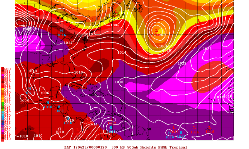
This WV loop really shows the Upper pattern well and if I'm seeing this correctly it looks like the shear might be lessening over the NW Caribbean in the next 24hrs.
http://mkwc.ifa.hawaii.edu/satellite/sa ... type=flash
http://mkwc.ifa.hawaii.edu/satellite/sa ... type=flash
0 likes
The following post is NOT an official forecast and should not be used as such. It is just the opinion of the poster and may or may not be backed by sound meteorological data. It is NOT endorsed by any professional institution including storm2k.org For Official Information please refer to the NHC and NWS products.
-
Rgv20

- S2K Supporter

- Posts: 2466
- Age: 39
- Joined: Wed Jan 05, 2011 5:42 pm
- Location: Edinburg/McAllen Tx
0zGFS trending weaker with the BOC Low....0zNOGAPS has a weak low drifting to the NE Mexican Coast by Friday Evening. Taking a closer look at the 0zGFS, the BOC disturbance is forecast to be in a low wind shear environment, descent 850mb Vorticity but it has too broad of a circulation.
0zGFS forecast for Friday Evening
On a side note the MJO is forecast to slow down in Region 1....Could that help the models get a better handle on the situation in the BOC as the MJO is not going to be racing like it was a couple of days?
ECMWF MJO Forecast
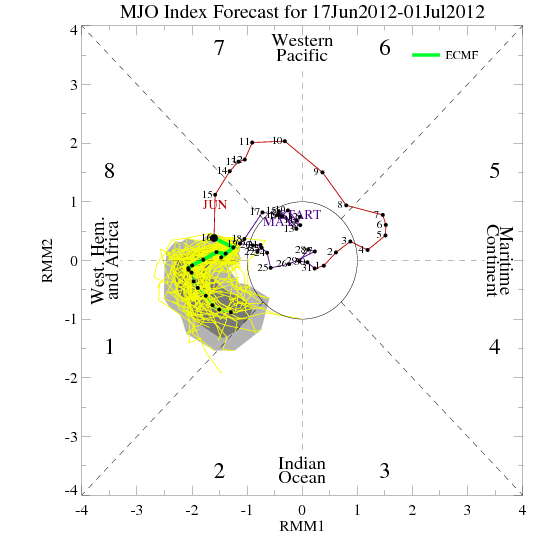
0zGFS forecast for Friday Evening
On a side note the MJO is forecast to slow down in Region 1....Could that help the models get a better handle on the situation in the BOC as the MJO is not going to be racing like it was a couple of days?
ECMWF MJO Forecast
0 likes
The following post is NOT an official forecast and should not be used as such. It is just the opinion of the poster and may or may not be backed by sound meteorological data. It is NOT endorsed by any professional institution including storm2k.org For Official Information please refer to the NHC and NWS products.

Re: NW Carribean / Southern GOM / BOC
NDG wrote:Long live king Euro.
Yes, absolutely.
Hey everyone, look at the 00z Canadian run!
0 likes
-
Hurricane Alexis

- Category 2

- Posts: 683
- Age: 29
- Joined: Thu Jun 14, 2012 7:59 pm
- Location: Miami,Florida
Re: NW Carribean / Southern GOM / BOC
Cyclenall wrote:NDG wrote:Long live king Euro.
Yes, absolutely.
Hey everyone, look at the 00z Canadian run!A hurricane forms after crossing south Florida (similar to how Wilma did) in the Atlantic.
What site do you use for the CMC?
0 likes
Personal Forecast Disclaimer:
The posts in this forum are NOT official forecast and should not be used as such. They are just the opinion of the poster and may or may not be backed by sound meteorological data. They are NOT endorsed by any professional institution or storm2k.org. For official information, please refer to the NHC and NWS products.
The posts in this forum are NOT official forecast and should not be used as such. They are just the opinion of the poster and may or may not be backed by sound meteorological data. They are NOT endorsed by any professional institution or storm2k.org. For official information, please refer to the NHC and NWS products.
-
USTropics
- Professional-Met

- Posts: 2737
- Joined: Sun Aug 12, 2007 3:45 am
- Location: Florida State University
Re: NW Carribean / Southern GOM / BOC
0z ECMWF shifted more north with the BOC system, bringing it close to the texas/mexico border. It also doesn't want to split the energy and send the other 1/2 towards the northeast as the 12z depicted, but rather shows a weak reflection developing in the Bahamas and moving east of Florida.

0 likes
-
cycloneye

- Admin

- Posts: 149276
- Age: 69
- Joined: Thu Oct 10, 2002 10:54 am
- Location: San Juan, Puerto Rico
Re: NW Carribean / Southern GOM / BOC
Heres the NHC marine discussion.
MARINE WEATHER DISCUSSION
NWS NATIONAL HURRICANE CENTER MIAMI FL
358 AM EDT MON JUN 18 2012
MARINE WEATHER DISCUSSION FOR THE GULF OF MEXICO...CARIBBEAN SEA
AND SOUTHWEST NORTH ATLC S OF 31N W OF 55W.
GULF OF MEXICO...
THE WEAK SURFACE TROUGH THAT HAD BEEN MOVING THROUGH THE NW GULF
APPEARS TO HAVE DAMPENED OUT AS OF 18/06Z. THIS LEAVES A SURFACE
RIDGE EXTENDING FROM THE CAROLINAS TO THE SW GULF WITH GENERALLY
LIGHT TO MODERATE SE WINDS OVER THE ENTIRE GULF. THE EXCEPTION IS
THE STRAITS OF FLORIDA WHERE 15 TO 20 KT EAST WINDS ARE NOTED.
SCATTERED SHOWERS AND A FEW THUNDERSTORMS LINGER OVER THE N
CENTRAL GULF...ON THE NORTH EDGE OF THE LOOP CURRENT AND UNDER AN
AREA OF UPPER DIVERGENCE. DRIER MID AND UPPER LEVEL AIR MOVING
INTO THIS AREA WILL INHIBIT CONVECTION THROUGH THE REMAINDER OF
THE DAY. THE PRES GRADIENT WILL TIGHTEN OVER THE EASTERN AND
CENTRAL GULF TUE BETWEEN THE HIGH PRES OVER THE CAROLINAS AND A
TROUGH MOVING TOWARD THE YUCATAN ACROSS THE NW CARIBBEAN. THE GFS
REMAINS THE STRONGEST SOLUTION SHOWING WINDS TO 25 KT OVER THE
EASTERN AND CENTRAL GULF THROUGH THU. THE ECMWF AND UKMET ON THE
OTHER HAND INDICATE WINDS INCREASING BUT STAYING IN THE 15 TO 20
KT RANGE. THE GFS HAS BEEN TRENDING WEAKER SHOWING THE AREA OF
FRESH TO STRONG WINDS DECREASING SOMEWHAT COMPARED TO EARLIER
RUNS AND IS MORE IN LINE WITH THE OTHER MODELS. THE FORECAST
FAVORS THE ECMWF/UKMET SOLUTIONS THROUGH THU. BOTH THE GFS AND
ECMWF SHOW AN AREA OF LOW PRES EMERGING OFF THE YUCATAN INTO THE
S CENTRAL GULF BY LATE THU...FURTHER EAST THAN EARLIER
RUNS...THEN SHIFTING WESTWARD TOWARD THE SW GULF FRI. THE
OFFICIAL FORECAST IS A BLEND OF GFS AND ECMWF WITH MODERATE TO
FRESH CYCLONIC FLOW IN A BROAD SWATH AROUND THE LOW...ALTHOUGH
FAVORING THE STRONGER GFS SHOWING N WINDS TO 25 KT BY FRI
AFTERNOON OFF THE COAST OF VERACRUZ AHEAD OF THE ADVANCING LOW
PRES. MODEL CONSENSUS HOLDS THE PRES TO 1007 MB BY LATE FRI.
EXPECT PERSISTENT CONVECTION ACROSS THE SOUTHERN GULF BY THU AND
FRI AS THE LOW MOVES INTO THE AREA.
CARIBBEAN SEA AND TROPICAL N ATLC W OF 55W...
1008 MB LOW PRES IS CENTERED NEAR 15N82W...HAVING MOVED NNW FROM
ITS POSITION OF THE N COAST OF PANAMA YESTERDAY. THE LOW IS JUST
OFF THE COAST NEAR THE NICARAGUA/HONDURAS BORDER AND APPEARS TO
BE STAYING OVER THE WATERS AS OPPOSED MAKING AN EARLY LANDFALL
FURTHER WEST. THIS IS ALLOWING THE LOW TO STAY INTACT AND DEEPEN
SLIGHTLY. HOWEVER...AN UPPER LOW IS PARKED OVER THE S CENTRAL
GULF OF MEXICO AND IS DELIVERING WESTERLY SHEAR ACROSS THE
SURFACE LOW. STRONG CONVECTION FLARING CURRENTLY SOUTH OF
JAMAICA...IS DISPLACED TOO FAR EAST TO ASSIST THE DEVELOPMENT OF
THE LOW. GLOBAL MODEL CONSENSUS INDICATES THE LOW WILL TRACK MORE
WNW AND HUG THE HONDURAN COAST THROUGH TUE...IN RESPONSE TO ATLC
RIDGING BUILD WEST TOWARD THE CARIBBEAN...BEFORE CROSSING THE
TERRAIN OVER BELIZE...NORTHERN GUATEMALA AND SOUTHERN YUCATAN WED.
THE UPPER SHEAR BACKS MORE TO THE SW AND DIMINISHES SOMEWHAT AS
THE UPPER LOW DRIFTS WEST THROUGH WED. HOWEVER THE MODEST SHEAR
ALONG WITH TERRAIN EFFECTS WILL KEEP THE LOW FROM DEEPENING
APPRECIABLY THROUGH WED. EXPECT CONTINUAL CONVECTION OVER THE NW
CARIBBEAN INTO THU AS THE THE LOW AND ITS ACCOMPANYING SURFACE
TROUGH MIGRATE TO THE NW
0 likes
Visit the Caribbean-Central America Weather Thread where you can find at first post web cams,radars
and observations from Caribbean basin members Click Here
and observations from Caribbean basin members Click Here
-
Aric Dunn
- Category 5
- Posts: 21238
- Age: 43
- Joined: Sun Sep 19, 2004 9:58 pm
- Location: Ready for the Chase.
- Contact:
vorticity is incrrasing alot in western carrib. convection is exlofind over that low down there. looks like it is the best chance gor devrlopment.
0 likes
Note: If I make a post that is brief. Please refer back to previous posts for the analysis or reasoning. I do not re-write/qoute what my initial post said each time.
If there is nothing before... then just ask
Space & Atmospheric Physicist, Embry-Riddle Aeronautical University,
I believe the sky is falling...
If there is nothing before... then just ask
Space & Atmospheric Physicist, Embry-Riddle Aeronautical University,
I believe the sky is falling...
-
cycloneye
- Admin
- Posts: 149276
- Age: 69
- Joined: Thu Oct 10, 2002 10:54 am
- Location: San Juan, Puerto Rico
Re: NW Carribean / Southern GOM / BOC
The area of interest is very big.

0 likes
Visit the Caribbean-Central America Weather Thread where you can find at first post web cams,radars
and observations from Caribbean basin members Click Here
and observations from Caribbean basin members Click Here

Re: NW Carribean / Southern GOM / BOC
Nice outflow on the convection at 15N 79W with increasing rain-rate.
http://www.ssd.noaa.gov/goes/east/watl/flash-wv.html
http://www.nrlmry.navy.mil/htdocs_dyn_p ... atest.html
Strong ULL at 33N 68W is supporting a poleward outflow channel for the convection to tap into.
http://www.ssd.noaa.gov/goes/east/nwatl/flash-wv.html
http://tropic.ssec.wisc.edu/real-time/w ... zoom=&time
A minor ULL at 23N 87W
http://www.ssd.noaa.gov/goes/east/watl/flash-wv.html
No UL PV over the convection
http://tropic.ssec.wisc.edu/real-time/w ... oom=&time=
If convection persists and / or hot-tower fires, an anti-cyclone could develop over this.
Looks very interesting.
http://www.ssd.noaa.gov/goes/east/watl/flash-wv.html
http://www.nrlmry.navy.mil/htdocs_dyn_p ... atest.html
Strong ULL at 33N 68W is supporting a poleward outflow channel for the convection to tap into.
http://www.ssd.noaa.gov/goes/east/nwatl/flash-wv.html
http://tropic.ssec.wisc.edu/real-time/w ... zoom=&time
A minor ULL at 23N 87W
http://www.ssd.noaa.gov/goes/east/watl/flash-wv.html
No UL PV over the convection
http://tropic.ssec.wisc.edu/real-time/w ... oom=&time=
If convection persists and / or hot-tower fires, an anti-cyclone could develop over this.
Looks very interesting.
0 likes
-
Rgv20
- S2K Supporter
- Posts: 2466
- Age: 39
- Joined: Wed Jan 05, 2011 5:42 pm
- Location: Edinburg/McAllen Tx
HPC early morning discussion
"REGARDING THE TROPICS/LOWER LATITUDE EVOLUTION... THE CANADIAN IS
THE CLEAR OUTLIER IN DEVELOPING A TROPICAL SYSTEM THAT TRACKS
ACROSS SRN FL/WRN ATLC AND BY DAY 7 ENDS UP NOT TOO FAR EWD OF THE
PRIMARY SFC LOW CLUSTERING NEAR NEW ENGLAND. REMAINING CONSENSUS
INDICATES A WAVY SFC FRONT/TROF OVER THE FL PENINSULA WITH SOME
WEAKENING LIKELY BY SAT-MON. MEANWHILE THERE CONTINUE TO BE
INDICATIONS OF PSBL DEVELOPMENT OVER THE SWRN GULF OF MEXICO BUT
ASIDE FROM THE 00Z ECMWF THERE IS CONSIDERABLE RELUCTANCE IN
GUIDANCE TO BRING ANY FEATURE N OF 23-24N LATITUDE. MANUAL FCST
REFLECTS YDAYS NHC/HPC COORDINATION WITH LATEST
GUIDANCE/EXTRAPOLATION USED FOR DAY 7."
Brownsville early morning discussion
"MODELS CONTINUE TO DIVERGE ON WHAT TO
DO WITH THE LOW PRESSURE FEATURE OVER THE BAY OF CAMPECHE AND THE
SOUTHERN GULF OF MEXICO...AS A RESULT HAVE KEPT PRECIP CHANCES ON
THE LOW SIDE."
0 likes
The following post is NOT an official forecast and should not be used as such. It is just the opinion of the poster and may or may not be backed by sound meteorological data. It is NOT endorsed by any professional institution including storm2k.org For Official Information please refer to the NHC and NWS products.

Nice west winds in the island of San Andres this morning. Yesterday at this time it was reporting light and variable winds as the low pressure center passed over it, now that the COC is north of the island closer to the Nica/Honduras border, they are getting the west wind.
Code: Select all
 METAR text:  SKSP 181100Z 26010KT 9999 FEW017 BKN200 27/25 A2977 REDZ
Conditions at:  SKSP (SAN ANDRES ISLAN, CO) observed 1100 UTC 18 June 2012
Temperature:  27.0°C (81°F)
Dewpoint:  25.0°C (77°F) [RH = 89%]
Pressure (altimeter):  29.77 inches Hg (1008.2 mb)
Winds:  from the W (260 degrees) at 12 MPH (10 knots; 5.2 m/s)
Visibility:  6 or more miles (10+ km)
Ceiling:  20000 feet AGL
Clouds:  few clouds at 1700 feet AGL
broken clouds at 20000 feet AGL
Weather:  no significant weather observed at this time
0 likes
Who is online
Users browsing this forum: No registered users and 151 guests