NW Carribean / Southern GOM / BOC (Is invest 96L)

This is the general tropical discussion area. Anyone can take their shot at predicting a storms path.

Moderator: S2k Moderators

Forum rules

The posts in this forum are NOT official forecasts and should not be used as such. They are just the opinion of the poster and may or may not be backed by sound meteorological data. They are NOT endorsed by any professional institution or STORM2K. For official information, please refer to products from the National Hurricane Center and National Weather Service.

Help Support Storm2K
Message
Author
User avatar
boca
Category 5
Category 5
Posts: 6367
Age: 60
Joined: Mon Dec 15, 2003 8:49 am
Location: Boca Raton,FL

Re:

#321 Postby boca » Mon Jun 18, 2012 7:36 pm

northjaxpro wrote:Yes, boca they did indeed enhance the GFS model, and apparently it has really made a signifcant difference for sure.


Yes I noticed the model is good and we can see how the GFS will do when we have storms to track,but I like the Euro too,but they do need an upgrade too
0 likes   

User avatar
South Texas Storms
Professional-Met
Professional-Met
Posts: 4226
Joined: Thu Jun 24, 2010 12:28 am
Location: Houston, TX

Re: Re:

#322 Postby South Texas Storms » Mon Jun 18, 2012 7:37 pm

boca wrote:
northjaxpro wrote:Yeah, the Tampa and Miami NWS mets are seemingly totally buying into the trends of the GFS runs today regarding their AFDs I read from their respective offices.

Now, I must add that GFS model runs for the most part have performed very well this early season with the development of Alberto and especially Beryl.


Also the GFS upgraded May 22nd as well.


Really? Can I see a link describing the upgrades they made? I didn't know it did!
0 likes   

User avatar
jasons2k
Storm2k Executive
Storm2k Executive
Posts: 8245
Age: 51
Joined: Wed Jul 06, 2005 12:32 pm
Location: The Woodlands, TX

Re: NW Carribean / Southern GOM / BOC

#323 Postby jasons2k » Mon Jun 18, 2012 7:39 pm

As you all know, the models will tend to flip flop with the ridge placement in question and the lack of a cyclone to track. In fact, it's a real mess right now and it probably won't be until Thursday when something does form.

A good place to check is always the HPC. They don't flip-flop like the models do and they coordinate with the NHC. They have it meandering in the western GOM for now, which tells me they aren't quite sure what to do with it yet either.

HPC plots: http://www.hpc.ncep.noaa.gov/medr/5dayfcst_wbg.gif

It may not go anywhere fast, which will make the timing of events more important down the line. That could all potentially change in the next few days depending on how fast the system evolves.
0 likes   

User avatar
northjaxpro
S2K Supporter
S2K Supporter
Posts: 8900
Joined: Mon Sep 27, 2010 11:21 am
Location: Jacksonville, FL

Re: NW Carribean / Southern GOM / BOC

#324 Postby northjaxpro » Mon Jun 18, 2012 7:43 pm

jasons wrote:As you all know, the models will tend to flip flop with the ridge placement in question and the lack of a cyclone to track. In fact, it's a real mess right now and it probably won't be until Thursday when something does form.

A good place to check is always the HPC. They don't flip-flop like the models do and they coordinate with the NHC. They have it meandering in the western GOM for now, which tells me they aren't quite sure what to do with it yet either.

HPC plots: http://www.hpc.ncep.noaa.gov/medr/5dayfcst_wbg.gif

It may not go anywhere fast, which will make the timing of events more important down the line. That could all potentially change in the next few days depending on how fast the system evolves.


Good observation jasons. I often look to HPC as well. Hopefully the models will have it nailed down or get into a better consensus with future runs.
0 likes   
NEVER, EVER SAY NEVER in the tropics and weather in general, and most importantly, with life itself!!

________________________________________________________________________________________

Fay 2008 Beryl 2012 Debby 2012 Colin 2016 Hermine 2016 Julia 2016 Matthew 2016 Irma 2017 Dorian 2019

User avatar
cycloneye
Admin
Admin
Posts: 145307
Age: 68
Joined: Thu Oct 10, 2002 10:54 am
Location: San Juan, Puerto Rico

Re: Re:

#325 Postby cycloneye » Mon Jun 18, 2012 7:43 pm

South Texas Storms wrote:
boca wrote:
northjaxpro wrote:Yeah, the Tampa and Miami NWS mets are seemingly totally buying into the trends of the GFS runs today regarding their AFDs I read from their respective offices.

Now, I must add that GFS model runs for the most part have performed very well this early season with the development of Alberto and especially Beryl.


Also the GFS upgraded May 22nd as well.


Really? Can I see a link describing the upgrades they made? I didn't know it did!


Here is the post from page 166 of the Global Models Discussion Thread eluding to the upgrade.

viewtopic.php?f=31&t=104813&st=0&sk=t&sd=a&start=3300
0 likes   
Visit the Caribbean-Central America Weather Thread where you can find at first post web cams,radars
and observations from Caribbean basin members Click Here

User avatar
Rgv20
S2K Supporter
S2K Supporter
Posts: 2466
Age: 38
Joined: Wed Jan 05, 2011 5:42 pm
Location: Edinburg/McAllen Tx

#326 Postby Rgv20 » Mon Jun 18, 2012 7:43 pm

Joe Bastardi Twitter

"@BigJoeBastardi:To be clear, system in Caribbean is a 3-5 day process if it develops and will be in gulf, but which would YOU think was worth watching"
0 likes   
The following post is NOT an official forecast and should not be used as such. It is just the opinion of the poster and may or may not be backed by sound meteorological data. It is NOT endorsed by any professional institution including storm2k.org For Official Information please refer to the NHC and NWS products.

User avatar
South Texas Storms
Professional-Met
Professional-Met
Posts: 4226
Joined: Thu Jun 24, 2010 12:28 am
Location: Houston, TX

Re: NW Carribean / Southern GOM / BOC

#327 Postby South Texas Storms » Mon Jun 18, 2012 7:48 pm

Thanks Luis and that is a very good post jasons. Well said.
0 likes   

User avatar
northjaxpro
S2K Supporter
S2K Supporter
Posts: 8900
Joined: Mon Sep 27, 2010 11:21 am
Location: Jacksonville, FL

Re: Re:

#328 Postby northjaxpro » Mon Jun 18, 2012 7:48 pm

South Texas Storms wrote:
boca wrote:
northjaxpro wrote:Yeah, the Tampa and Miami NWS mets are seemingly totally buying into the trends of the GFS runs today regarding their AFDs I read from their respective offices.

Now, I must add that GFS model runs for the most part have performed very well this early season with the development of Alberto and especially Beryl.


Also the GFS upgraded May 22nd as well.


Really? Can I see a link describing the upgrades they made? I didn't know it did!


Here is the link:

http://www.emc.ncep.noaa.gov/index.php?branch=GFS
0 likes   
NEVER, EVER SAY NEVER in the tropics and weather in general, and most importantly, with life itself!!

________________________________________________________________________________________

Fay 2008 Beryl 2012 Debby 2012 Colin 2016 Hermine 2016 Julia 2016 Matthew 2016 Irma 2017 Dorian 2019

User avatar
Rgv20
S2K Supporter
S2K Supporter
Posts: 2466
Age: 38
Joined: Wed Jan 05, 2011 5:42 pm
Location: Edinburg/McAllen Tx

Re: NW Carribean / Southern GOM / BOC

#329 Postby Rgv20 » Mon Jun 18, 2012 7:52 pm

jasons wrote:As you all know, the models will tend to flip flop with the ridge placement in question and the lack of a cyclone to track. In fact, it's a real mess right now and it probably won't be until Thursday when something does form.

A good place to check is always the HPC. They don't flip-flop like the models do and they coordinate with the NHC. They have it meandering in the western GOM for now, which tells me they aren't quite sure what to do with it yet either.

HPC plots: http://www.hpc.ncep.noaa.gov/medr/5dayfcst_wbg.gif

It may not go anywhere fast, which will make the timing of events more important down the line. That could all potentially change in the next few days depending on how fast the system evolves.


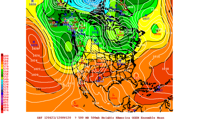
The reason HPC does not Flip Flop is that they go with a consensus of the Ensembles which often lead to better results but the details are sketchy.

For example the 12zCMC Ensembles have a broad low in the western gulf in 5 days while the operational 12CMC has a TC going until the Northern Gulf Coast.

Image
0 likes   
The following post is NOT an official forecast and should not be used as such. It is just the opinion of the poster and may or may not be backed by sound meteorological data. It is NOT endorsed by any professional institution including storm2k.org For Official Information please refer to the NHC and NWS products.

User avatar
boca
Category 5
Category 5
Posts: 6367
Age: 60
Joined: Mon Dec 15, 2003 8:49 am
Location: Boca Raton,FL

Re: NW Carribean / Southern GOM / BOC

#330 Postby boca » Mon Jun 18, 2012 7:58 pm

Rgv20 wrote:
jasons wrote:As you all know, the models will tend to flip flop with the ridge placement in question and the lack of a cyclone to track. In fact, it's a real mess right now and it probably won't be until Thursday when something does form.

A good place to check is always the HPC. They don't flip-flop like the models do and they coordinate with the NHC. They have it meandering in the western GOM for now, which tells me they aren't quite sure what to do with it yet either.

HPC plots: http://www.hpc.ncep.noaa.gov/medr/5dayfcst_wbg.gif

It may not go anywhere fast, which will make the timing of events more important down the line. That could all potentially change in the next few days depending on how fast the system evolves.


The reason HPC does not Flip Flop is that they go with a consensus of the Ensembles which often lead to better results but the details are sketchy.

For example the 12zCMC Ensembles have a broad low in the western gulf in 5 days while the operational 12CMC has a TC going until the Northern Gulf Coast.

Image


Thats good info I didn't know that about the HPC
0 likes   

User avatar
NDG
S2K Supporter
S2K Supporter
Posts: 15446
Joined: Sun Jul 09, 2006 10:14 pm
Location: Orlando, FL

Re:

#331 Postby NDG » Mon Jun 18, 2012 8:01 pm

northjaxpro wrote:Yeah, the Tampa and Miami NWS mets are seemingly totally buying into the trends of the GFS runs today regarding their AFDs I read from their respective offices.

Now, I must add that GFS model runs for the most part have performed very well this early season with the development of Alberto and especially Beryl.


I am sorry to disagree with you. The GFS did not do that well with both Alberto and Beryl.
With Alberto it had its circulation by a good 100-150 miles off and very broad.
With Beryl it kept showing development in the NW Caribbean, while the euro never really bought on the idea & was the first one to show that development was going to be off of the SE US and to move it westward towards FL, well before the GFS.
Last edited by NDG on Mon Jun 18, 2012 8:02 pm, edited 1 time in total.
0 likes   

User avatar
Kingarabian
S2K Supporter
S2K Supporter
Posts: 15980
Joined: Sat Aug 08, 2009 3:06 am
Location: Honolulu, Hawaii

#332 Postby Kingarabian » Mon Jun 18, 2012 8:02 pm

So whats the difference between ensembles and the model itself?
0 likes   
RIP Kobe Bryant

User avatar
Ntxw
Storm2k Moderator
Storm2k Moderator
Posts: 22785
Joined: Wed Oct 21, 2009 6:34 pm
Location: DFW, Texas

Re:

#333 Postby Ntxw » Mon Jun 18, 2012 8:09 pm

Kingarabian wrote:So whats the difference between ensembles and the model itself?


Ensembles are different runs of that model using slightly adjusted initiation data. Example GFS ensembles is essentially the GFS ran several times but with data changed to it. This sometimes can correct model biases. However ensembles are lower resolution than the parent model. Usually what's posted is the average solution given out by the different ensemble members collectively.
0 likes   
The above post and any post by Ntxw is NOT an official forecast and should not be used as such. It is just the opinion of the poster and may or may not be backed by sound meteorological data. It is NOT endorsed by any professional institution including Storm2k. For official information, please refer to NWS products.

  Help support Storm2K!
Help Support Storm2K

User avatar
northjaxpro
S2K Supporter
S2K Supporter
Posts: 8900
Joined: Mon Sep 27, 2010 11:21 am
Location: Jacksonville, FL

Re: Re:

#334 Postby northjaxpro » Mon Jun 18, 2012 8:10 pm

NDG wrote:
northjaxpro wrote:Yeah, the Tampa and Miami NWS mets are seemingly totally buying into the trends of the GFS runs today regarding their AFDs I read from their respective offices.

Now, I must add that GFS model runs for the most part have performed very well this early season with the development of Alberto and especially Beryl.


I am sorry to disagree with you. The GFS did not do that well with both Alberto and Beryl.
With Alberto it had its circulation by a good 100-150 miles off and very broad.
With Beryl it kept showing development in the NW Caribbean, while the euro never really bought on the idea & was the first one to show that development was going to be off of the SE US and to move it westward towards FL, well before the GFS.


I thought GFS was the model that consistently showed Beryl with the solution latching onto a NE Florida landfall, with the Euro, CMC and NAM joining it later. I may be incorrect with my assessment NDG and it may have been the EURO that had it first.
0 likes   
NEVER, EVER SAY NEVER in the tropics and weather in general, and most importantly, with life itself!!

________________________________________________________________________________________

Fay 2008 Beryl 2012 Debby 2012 Colin 2016 Hermine 2016 Julia 2016 Matthew 2016 Irma 2017 Dorian 2019

User avatar
Ntxw
Storm2k Moderator
Storm2k Moderator
Posts: 22785
Joined: Wed Oct 21, 2009 6:34 pm
Location: DFW, Texas

Re: Re:

#335 Postby Ntxw » Mon Jun 18, 2012 8:13 pm

northjaxpro wrote:I thought GFS was the model that consistently showed Beryl with the solution latching onto a NE Florida landfall, with the Euro, CMC and NAM joining it later. I may be incorrect with my assessment NDG and it may have been the EURO that had it first.


NDG is correct that the euro had it first out in 5+ days ;). It got less aggressive as the other models latched on but was the first. Euro had it as a SC-ish landfall though early on.
0 likes   
The above post and any post by Ntxw is NOT an official forecast and should not be used as such. It is just the opinion of the poster and may or may not be backed by sound meteorological data. It is NOT endorsed by any professional institution including Storm2k. For official information, please refer to NWS products.


  Help support Storm2K!

Help Support Storm2K


User avatar
northjaxpro
S2K Supporter
S2K Supporter
Posts: 8900
Joined: Mon Sep 27, 2010 11:21 am
Location: Jacksonville, FL

Re: Re:

#336 Postby northjaxpro » Mon Jun 18, 2012 8:28 pm

Ntxw wrote:
northjaxpro wrote:I thought GFS was the model that consistently showed Beryl with the solution latching onto a NE Florida landfall, with the Euro, CMC and NAM joining it later. I may be incorrect with my assessment NDG and it may have been the EURO that had it first.


NDG is correct that the euro had it first out in 5+ days ;). It got less aggressive as the other models latched on but was the first. Euro had it as a SC-ish landfall though early on.


I went back though the old threads and NDG you are correct. EURO was the model to first latch onto the intial development of the Low pressure in the NW caribbean. As it moved northeast, as Ntxw pointed out, the models were not in agreement, but the GFS was the model which picked up on the development of Beryl strengthening and transitioning into a tropical cyclone and headed back towards the NE FL coast. That 's what I was fixated on initially regarding the model on Beryl.

Thanks NDG and to Ntwx for the clarification. That's why you guys here on Storm2K are awesome and why this is my hangout on the blogosphere! 8-)
0 likes   
NEVER, EVER SAY NEVER in the tropics and weather in general, and most importantly, with life itself!!

________________________________________________________________________________________

Fay 2008 Beryl 2012 Debby 2012 Colin 2016 Hermine 2016 Julia 2016 Matthew 2016 Irma 2017 Dorian 2019

User avatar
cycloneye
Admin
Admin
Posts: 145307
Age: 68
Joined: Thu Oct 10, 2002 10:54 am
Location: San Juan, Puerto Rico

Re: NW Carribean / Southern GOM / BOC

#337 Postby cycloneye » Mon Jun 18, 2012 8:33 pm

Ok guys,let's return to the topic about the NW Caribbean/SGOM/BOC possible tropical development.
0 likes   
Visit the Caribbean-Central America Weather Thread where you can find at first post web cams,radars
and observations from Caribbean basin members Click Here

User avatar
northjaxpro
S2K Supporter
S2K Supporter
Posts: 8900
Joined: Mon Sep 27, 2010 11:21 am
Location: Jacksonville, FL

Re: NW Carribean / Southern GOM / BOC

#338 Postby northjaxpro » Mon Jun 18, 2012 8:39 pm

cycloneye wrote:Ok guys,let's return to the topic about the NW Caribbean/SGOM/BOC possible tropical development.


I apologize for the deviation Cycloneye. We still are focused on the main topic of the thread I assure you 8-)
0 likes   
NEVER, EVER SAY NEVER in the tropics and weather in general, and most importantly, with life itself!!

________________________________________________________________________________________

Fay 2008 Beryl 2012 Debby 2012 Colin 2016 Hermine 2016 Julia 2016 Matthew 2016 Irma 2017 Dorian 2019

floridasun78
Category 5
Category 5
Posts: 3755
Joined: Sun May 17, 2009 10:16 pm
Location: miami fl

#339 Postby floridasun78 » Mon Jun 18, 2012 8:58 pm

it look were low at it on dry side most storm are to east of low in nw carribbean
0 likes   

User avatar
cycloneye
Admin
Admin
Posts: 145307
Age: 68
Joined: Thu Oct 10, 2002 10:54 am
Location: San Juan, Puerto Rico

Re: NW Carribean / Southern GOM / BOC

#340 Postby cycloneye » Mon Jun 18, 2012 9:48 pm

Just out is the 00z Surface Analysis.

Image
0 likes   
Visit the Caribbean-Central America Weather Thread where you can find at first post web cams,radars
and observations from Caribbean basin members Click Here


Return to “Talkin' Tropics”

Who is online

Users browsing this forum: cajungal, Google Adsense [Bot], KeysRedWine, Steve H. and 41 guests