NW Carribean / Southern GOM / BOC (Is invest 96L)
Moderator: S2k Moderators
Forum rules

The posts in this forum are NOT official forecasts and should not be used as such. They are just the opinion of the poster and may or may not be backed by sound meteorological data. They are NOT endorsed by any professional institution or STORM2K. For official information, please refer to products from the National Hurricane Center and National Weather Service.
-
Dean4Storms
- S2K Supporter

- Posts: 6358
- Age: 63
- Joined: Sun Aug 31, 2003 1:01 pm
- Location: Miramar Bch. FL

-
cycloneye

- Admin

- Posts: 149278
- Age: 69
- Joined: Thu Oct 10, 2002 10:54 am
- Location: San Juan, Puerto Rico
Re:
Lorenzo wrote:I see convection blowing up above puerto Rico.Could the tropical system form in bahmas form into a cat 1 hurricane hit se Florida then rode up the east coast as a rainstorm?Or go in the gulf and do a Wilma track?
Welcome to Storm2k. That is part of an upper trough that has lingered for the past few days in the Western Atlantic,but is slowly moving away. No development from that area. The area to watch in the next few days is from the NW Caribbean thru the Bay of Campeche/Central Gulf of Mexico.
0 likes
Visit the Caribbean-Central America Weather Thread where you can find at first post web cams,radars
and observations from Caribbean basin members Click Here
and observations from Caribbean basin members Click Here
-
floridasun78
- Category 5

- Posts: 3755
- Joined: Sun May 17, 2009 10:16 pm
- Location: miami fl
-
South Texas Storms

- Professional-Met

- Posts: 4256
- Joined: Thu Jun 24, 2010 12:28 am
- Location: Houston, TX
Re: NW Carribean / Southern GOM / BOC
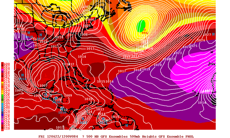
0z NAM still shows a tropical low approaching Texas in 84 hours. It also has a low in the BOC this run as well.

Uploaded with ImageShack.us

Uploaded with ImageShack.us
0 likes


Re: NW Carribean / Southern GOM / BOC
South Texas Storms wrote:0z NAM still shows a tropical low approaching Texas in 84 hours. It also has a low in the BOC this run as well.
http://img94.imageshack.us/img94/1773/namwnatl08410mwndprecip.gif
Uploaded with ImageShack.us
I can dig that run....
0 likes
-
South Texas Storms
- Professional-Met
- Posts: 4256
- Joined: Thu Jun 24, 2010 12:28 am
- Location: Houston, TX
-
thundercam96

- Tropical Storm

- Posts: 129
- Joined: Thu Aug 18, 2011 3:01 pm
- Location: Boston, MA
Re:
TexWx wrote:We've been in this "funk" since the day after Ike.
It's like everything changed after that.
What do you mean by "Funk". You Mean Climate Wise?
0 likes
Fay '08 / Mathew 16'
Personal Forecast Disclaimer: I am not a certified meteorologist, therefore, what is posted on this forum under my header should not be treated as an official forecast. Please refer to the NWS/NHC products for forecast information.
Personal Forecast Disclaimer: I am not a certified meteorologist, therefore, what is posted on this forum under my header should not be treated as an official forecast. Please refer to the NWS/NHC products for forecast information.
-
Rgv20

- S2K Supporter
- Posts: 2466
- Age: 39
- Joined: Wed Jan 05, 2011 5:42 pm
- Location: Edinburg/McAllen Tx
00zGFS develops a disturbance at the earliest on Friday morning than it losses it and comes back around Sunday. By Monday morning it has a 1006mb low ESE of Brownsville which is in descent agreement with the 12zECMWF. It would be nice if we could start getting some consistent model support as lately they have been hit or miss.
0 likes
The following post is NOT an official forecast and should not be used as such. It is just the opinion of the poster and may or may not be backed by sound meteorological data. It is NOT endorsed by any professional institution including storm2k.org For Official Information please refer to the NHC and NWS products.
Re: Re:
thundercam96 wrote:TexWx wrote:We've been in this "funk" since the day after Ike.
It's like everything changed after that.
What do you mean by "Funk". You Mean Climate Wise?
Yes, it's just been dry since then.
Heck, the day after Ike we had a dry cool front.
Not that I'm complaining about that. It was great when we had no power for a week.
0 likes
-
Rgv20
- S2K Supporter
- Posts: 2466
- Age: 39
- Joined: Wed Jan 05, 2011 5:42 pm
- Location: Edinburg/McAllen Tx
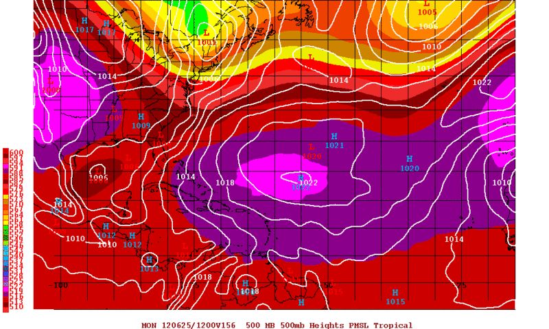
Well the first real shot of development looks to be in 3 days just NW of the Yucatan Peninsula according to 0zGFS Ensembles,12zECMWF, and 12zECMWF Ensembles....At least we will have a better idea by then.
0zGFS Ensemble Means forecast valid for Friday Morning...has a low pressure just NW of the Yucatan.
0zGFS Ensemble Means forecast valid for Friday Morning...has a low pressure just NW of the Yucatan.
0 likes
The following post is NOT an official forecast and should not be used as such. It is just the opinion of the poster and may or may not be backed by sound meteorological data. It is NOT endorsed by any professional institution including storm2k.org For Official Information please refer to the NHC and NWS products.
-
Brent
- S2K Supporter
- Posts: 38729
- Age: 37
- Joined: Sun May 16, 2004 10:30 pm
- Location: Tulsa Oklahoma
- Contact:
Re: NW Carribean / Southern GOM / BOC
TROPICAL WEATHER OUTLOOK
NWS NATIONAL HURRICANE CENTER MIAMI FL
200 AM EDT TUE JUN 19 2012
FOR THE NORTH ATLANTIC...CARIBBEAN SEA AND THE GULF OF MEXICO...
2. A LARGE AREA OF CLOUDINESS...SHOWERS...AND A FEW THUNDERSTORMS OVER
THE NORTHWESTERN CARIBBEAN SEA STRETCHING INTO THE SOUTHWESTERN
ATLANTIC OCEAN IS ASSOCIATED WITH A SURFACE TROUGH. ALTHOUGH
UPPER-LEVEL CONDITIONS ARE NOT EXPECTED TO BE PARTICULARLY
CONDUCIVE FOR DEVELOPMENT OF THIS SYSTEM...AREAS OF HEAVY RAINFALL
ARE LIKELY DURING THE NEXT COUPLE OF DAYS OVER THE CAYMAN
ISLANDS...CUBA...THE BAHAMAS...AND SOUTH FLORIDA. THIS SYSTEM HAS
A LOW CHANCE...10 PERCENT...OF BECOMING A TROPICAL CYCLONE OVER THE
NEXT 48 HOURS AS IT MOVES NORTHWESTWARD AT 5 TO 10 MPH.
ELSEWHERE...TROPICAL CYCLONE FORMATION IS NOT EXPECTED DURING THE
NEXT 48 HOURS.
&&
HIGH SEAS FORECASTS ISSUED BY THE NATIONAL WEATHER SERVICE CAN BE
FOUND UNDER AWIPS HEADER NFDHSFAT1 AND WMO HEADER FZNT01 KWBC.
$$
FORECASTER BLAKE
0 likes
#neversummer
-
South Texas Storms
- Professional-Met
- Posts: 4256
- Joined: Thu Jun 24, 2010 12:28 am
- Location: Houston, TX
-
SETXWXLADY
- Tropical Storm
- Posts: 216
- Joined: Wed May 20, 2009 3:26 pm
- Location: SE TX Orange County
Re: NW Carribean / Southern GOM / BOC
South Texas Storms wrote:0z cmc is pretty interesting.
http://moe.met.fsu.edu/cgi-bin/cmctc2.c ... =Animation
Finally into Brownsville at 192. So far the models are starting to come together. The EURO yet to be seen of course.

0 likes
Re: NW Carribean / Southern GOM / BOC
I haven't been following lately, trying to catch up.
Seems like models are finally converging on a broad low (POSSIBLY tropical low) making landfall on the Southern Texas coast?
Correct me if im wrong please...
Seems like models are finally converging on a broad low (POSSIBLY tropical low) making landfall on the Southern Texas coast?
Correct me if im wrong please...
0 likes
-
cycloneye
- Admin
- Posts: 149278
- Age: 69
- Joined: Thu Oct 10, 2002 10:54 am
- Location: San Juan, Puerto Rico
Re: NW Carribean / Southern GOM / BOC
NHC Marine Discussion:
MARINE WEATHER DISCUSSION
NWS NATIONAL HURRICANE CENTER MIAMI FL
353 AM EDT TUE JUN 19 2012
MARINE WEATHER DISCUSSION FOR THE GULF OF MEXICO...CARIBBEAN SEA
AND SOUTHWEST NORTH ATLC S OF 31N W OF 55W.
GULF OF MEXICO...
CMAN...SHIP AND SCATTEROMETER DATA IN THE STRAITS OF FLORIDA SHOW EAST
WINDS ARE STARTING TO INCREASE...BETWEEN A SHARP TROUGH OVER THE
NW CARIBBEAN AND HIGH PRES OFF THE CAROLINAS. THE MAIN ISSUE
THROUGH THE WEEKEND WILL BE THE ADVANCE OF 1009 MB LOW PRES NOW
OVER HONDURAS MOVING THROUGH YUCATAN AND INTO THE S CENTRAL GULF
BY LATE THU. THE LATEST GFS AND ECMWF ARE IN DECENT AGREEMENT
SHOW THIS FEATURE AS A BROAD LOW REACHING THE WEST CENTRAL GULF
NEAR 24N93W BY EARLY SAT WITH A MSLP AROUND 1006 MB. THE UKMET
AND NOGAPS ARE SIMILAR BUT SHOW LOW PRES IN THE NW GULF BY EARLY
SAT. THE OFFICIAL FORECAST FAVORS A BLEND OF THE GFS AND
ECMWF...BUT FAVORS THE STRONGER GFS REGARDING FRESH SOUTHERLY FLOW
OVER THE EASTERN GULF...BETWEEN THE LOW PRES OVER THE WESTERN
GULF AND THE ATLC RIDGE TO THE EAST. SEAS WILL REACH 7 FT OVER
THE NE GULF BY LATE SAT DUE TO FRESH SOUTHERLY FLOW. EXPECT
SCATTERED TO NUMEROUS SHOWERS AND EMBEDDED THUNDERSTORMS
SPREADING ACROSS THE EASTERN GULF AS THE TROUGH MOVES THROUGH THE
AREA FROM WED ONWARD TO THE WEEKEND.
CARIBBEAN SEA AND TROPICAL N ATLC W OF 55W...
RECENT OBSERVATIONS INDICATE THE 1009 MB SURFACE LOW THAT HAD
BEEN OFF NE NICARAGUA 24 HOURS AGO IS NOW OVER EASTERN
HONDURAS...WITH AN ATTENDANT TROUGH EXTENDING TOWARD CENTRAL
CUBA. THE LOW AND TROUGH COMBINATION WILL MIGRATE ACROSS THE NW
CARIBBEAN AND YUCATAN PENINSULA THROUGH LATE THU. SW WINDS ALOFT
CONTINUE TO SHEAR THE CONVECTION WELL TO THE NE OF THE CENTER.
THE UPPER SHEAR AND INTERACTIONS WITH THE LAND ARE PREVENTING THE
LOW FROM SIGNIFICANTLY DEEPENING IN THE NEAR TERM. 15 TO 20 KT NE
TO E WINDS ARE NOTED OVER THE FAR NW CARIBBEAN AHEAD OF THE
TROUGH.
0 likes
Visit the Caribbean-Central America Weather Thread where you can find at first post web cams,radars
and observations from Caribbean basin members Click Here
and observations from Caribbean basin members Click Here

Re: NW Carribean / Southern GOM / BOC
So now that the NHC highlighted the area yellow, last night's Euro keeps the disturbance broader than previous runs. It surely is not painting a pretty picture in the upper levels like it did a few days ago for the GOM.
0 likes
-
cycloneye
- Admin
- Posts: 149278
- Age: 69
- Joined: Thu Oct 10, 2002 10:54 am
- Location: San Juan, Puerto Rico
Re: NW Carribean / Southern GOM / BOC
From the NWS Corpus Christi:
RIDGE THEN EXPECTED TO
BREAK DOWN SLIGHTLY EARLY NEXT WEEK WITH A TROPICAL DISTURBANCE TO
MOVE INTO THE WEST GULF. STILL SOME UNCERTAINTY AS TO HOW
DISTURBANCE AND ASSOCIATED MOISTURE WILL PAN OUT LATE IN THE
EXTENDED PERIOD. GFS APPEARS TO BE SUFFERING FROM LATENT HEAT
BUNDLING ISSUES WITH PIECES OF ENERGY BREAKING OFF ACROSS THE GULF.
ECMWF LOOKS MORE REALISTIC WITH BROAD LOW PRESSURE AND ASSOCIATED
MOISTURE ADVECTING TOWARDS S TX. MAIN VARIABLE WILL BE HOW STRONG
MENTIONED RIDGE BECOMES AND IF TROPICAL MOISTURE IS SQUEEZED TO OUR
SOUTH ACROSS DEEP S TX OR IF MOISTURE CAN INFILTRATE OUR AREA.
0 likes
Visit the Caribbean-Central America Weather Thread where you can find at first post web cams,radars
and observations from Caribbean basin members Click Here
and observations from Caribbean basin members Click Here
-
cycloneye
- Admin
- Posts: 149278
- Age: 69
- Joined: Thu Oct 10, 2002 10:54 am
- Location: San Juan, Puerto Rico
Re: NW Carribean / Southern GOM / BOC
8 AM Tropical Weather Outlook:
A LARGE AREA OF CLOUDINESS...SHOWERS...AND A FEW THUNDERSTORMS
OVER THE NORTHWESTERN CARIBBEAN SEA STRETCHING INTO THE
SOUTHWESTERN ATLANTIC OCEAN IS ASSOCIATED WITH A SURFACE TROUGH.
ALTHOUGH UPPER-LEVEL CONDITIONS ARE NOT EXPECTED TO BE PARTICULARLY
CONDUCIVE FOR DEVELOPMENT OF THIS SYSTEM...AREAS OF HEAVY RAINFALL
ARE LIKELY DURING THE NEXT COUPLE OF DAYS OVER THE CAYMAN
ISLANDS...CUBA...THE BAHAMAS...AND SOUTH FLORIDA. THIS SYSTEM HAS
A LOW CHANCE...10 PERCENT...OF BECOMING A TROPICAL CYCLONE OVER THE
NEXT 48 HOURS AS IT MOVES NORTHWESTWARD AT 5 TO 10 MPH.
0 likes
Visit the Caribbean-Central America Weather Thread where you can find at first post web cams,radars
and observations from Caribbean basin members Click Here
and observations from Caribbean basin members Click Here
Who is online
Users browsing this forum: No registered users and 188 guests