12z CMC ... similar to last
http://moe.met.fsu.edu/cgi-bin/cmctc2.c ... =Animation
NW Carribean / Southern GOM / BOC (Is invest 96L)
Moderator: S2k Moderators
Forum rules

The posts in this forum are NOT official forecasts and should not be used as such. They are just the opinion of the poster and may or may not be backed by sound meteorological data. They are NOT endorsed by any professional institution or STORM2K. For official information, please refer to products from the National Hurricane Center and National Weather Service.
-
Aric Dunn
- Category 5

- Posts: 21238
- Age: 43
- Joined: Sun Sep 19, 2004 9:58 pm
- Location: Ready for the Chase.
- Contact:
0 likes
Note: If I make a post that is brief. Please refer back to previous posts for the analysis or reasoning. I do not re-write/qoute what my initial post said each time.
If there is nothing before... then just ask
Space & Atmospheric Physicist, Embry-Riddle Aeronautical University,
I believe the sky is falling...
If there is nothing before... then just ask
Space & Atmospheric Physicist, Embry-Riddle Aeronautical University,
I believe the sky is falling...
-
cycloneye

- Admin

- Posts: 149278
- Age: 69
- Joined: Thu Oct 10, 2002 10:54 am
- Location: San Juan, Puerto Rico
Re:
Aric Dunn wrote:For all we know those random solutions that had development near the Bahamas will happen.
At this point nothing is discounted with the many different scenarios painted by the models.
0 likes
Visit the Caribbean-Central America Weather Thread where you can find at first post web cams,radars
and observations from Caribbean basin members Click Here
and observations from Caribbean basin members Click Here

Re: NW Carribean / Southern GOM / BOC
Pattern keeps repeating here
ULL diving to S. Mex -and 1 in central Gulf
Pull up dry air - cause sheer. To come -Must be a right sided weather maker to effect Fl -again
Just a guess here -may be another Hybrid thingy
http://www.ssec.wisc.edu/data/geo/index ... thod=flash
ULL diving to S. Mex -and 1 in central Gulf
Pull up dry air - cause sheer. To come -Must be a right sided weather maker to effect Fl -again
Just a guess here -may be another Hybrid thingy
http://www.ssec.wisc.edu/data/geo/index ... thod=flash
0 likes
-
northjaxpro

- S2K Supporter

- Posts: 8900
- Joined: Mon Sep 27, 2010 11:21 am
- Location: Jacksonville, FL
Re: NW Carribean / Southern GOM / BOC
crimi481 wrote:Pattern keeps repeating here
ULL diving to S. Mex -and 1 in central Gulf
Pull up dry air - cause sheer. To come -Must be a right sided weather maker to effect Fl -again
Just a guess here -may be another Hybrid thingy
http://www.ssec.wisc.edu/data/geo/index ... thod=flash
For the time being, I have resigned myself to this thinking for now. Models are simply having too difficult of a time consolidating a Low presure center in one specific region. They have been all over the place.
Last edited by northjaxpro on Tue Jun 19, 2012 12:43 pm, edited 1 time in total.
0 likes
NEVER, EVER SAY NEVER in the tropics and weather in general, and most importantly, with life itself!!
________________________________________________________________________________________
Fay 2008 Beryl 2012 Debby 2012 Colin 2016 Hermine 2016 Julia 2016 Matthew 2016 Irma 2017 Dorian 2019
________________________________________________________________________________________
Fay 2008 Beryl 2012 Debby 2012 Colin 2016 Hermine 2016 Julia 2016 Matthew 2016 Irma 2017 Dorian 2019

Re: NW Carribean / Southern GOM / BOC
seems attm that vort has decreased in the area...
http://tropic.ssec.wisc.edu/real-time/w ... oom=&time=
http://tropic.ssec.wisc.edu/real-time/w ... oom=&time=
0 likes
-
Aric Dunn
- Category 5
- Posts: 21238
- Age: 43
- Joined: Sun Sep 19, 2004 9:58 pm
- Location: Ready for the Chase.
- Contact:
Re: NW Carribean / Southern GOM / BOC
ROCK wrote:seems attm that vort has decreased in the area...
http://tropic.ssec.wisc.edu/real-time/w ... oom=&time=
?? its higher. if you go back 3 hrs its higher now than earlier.
0 likes
Note: If I make a post that is brief. Please refer back to previous posts for the analysis or reasoning. I do not re-write/qoute what my initial post said each time.
If there is nothing before... then just ask
Space & Atmospheric Physicist, Embry-Riddle Aeronautical University,
I believe the sky is falling...
If there is nothing before... then just ask
Space & Atmospheric Physicist, Embry-Riddle Aeronautical University,
I believe the sky is falling...


Re: NW Carribean / Southern GOM / BOC
baytownwx wrote:I have been a lurker for awhile.....love this site very informative!
Youtube video from tropicaltidbits.com.....Seems to think this area could end up being an Allison senario, but just a bit further south down the texas coast. Will be interesting to see how this pans out...
http://youtu.be/k-GGNWIFoUA?hd=1
Interesting stuff.... I don't think he was talking about Allison from 2001, though.
0 likes
Re: NW Carribean / Southern GOM / BOC
Overall weather/ atmosheric patterns have been like from another Planet (last 2-3 years)
La Nina - Lo Nonna - Los Ninanonna. What the heck?
Will normal ever return?
La Nina - Lo Nonna - Los Ninanonna. What the heck?
Will normal ever return?
0 likes
Re: NW Carribean / Southern GOM / BOC
Aric Dunn wrote:ROCK wrote:seems attm that vort has decreased in the area...
http://tropic.ssec.wisc.edu/real-time/w ... oom=&time=
?? its higher. if you go back 3 hrs its higher now than earlier.
must not be looking at the same map....
0 likes
-
Aric Dunn
- Category 5
- Posts: 21238
- Age: 43
- Joined: Sun Sep 19, 2004 9:58 pm
- Location: Ready for the Chase.
- Contact:
Re: NW Carribean / Southern GOM / BOC
ROCK wrote:Aric Dunn wrote:ROCK wrote:seems attm that vort has decreased in the area...
http://tropic.ssec.wisc.edu/real-time/w ... oom=&time=
?? its higher. if you go back 3 hrs its higher now than earlier.
must not be looking at the same map....
guess its close. a little farther north is all.
3 hours ago..
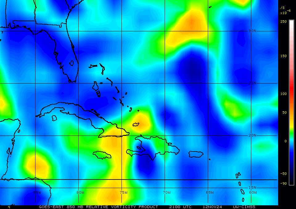
now'

0 likes
Note: If I make a post that is brief. Please refer back to previous posts for the analysis or reasoning. I do not re-write/qoute what my initial post said each time.
If there is nothing before... then just ask
Space & Atmospheric Physicist, Embry-Riddle Aeronautical University,
I believe the sky is falling...
If there is nothing before... then just ask
Space & Atmospheric Physicist, Embry-Riddle Aeronautical University,
I believe the sky is falling...
-
cycloneye
- Admin
- Posts: 149278
- Age: 69
- Joined: Thu Oct 10, 2002 10:54 am
- Location: San Juan, Puerto Rico
Re: NW Carribean / Southern GOM / BOC
Remains at 10%.
A LARGE AREA OF CLOUDINESS...SHOWERS...AND THUNDERSTORMS OVER
THE NORTHWESTERN CARIBBEAN SEA EXTENDING NORTHWARD ACROSS THE
STRAITS OF FLORIDA AND THE BAHAMAS IS ASSOCIATED WITH A SURFACE
TROUGH. ALTHOUGH UPPER-LEVEL CONDITIONS ARE NOT EXPECTED TO BE
PARTICULARLY CONDUCIVE FOR DEVELOPMENT OF THIS SYSTEM...AREAS OF
HEAVY RAINFALL ARE LIKELY DURING THE NEXT COUPLE OF DAYS OVER THE
CAYMAN ISLANDS...CUBA...THE BAHAMAS...AND SOUTHERN FLORIDA. THIS
SYSTEM HAS A LOW CHANCE...10 PERCENT...OF BECOMING A TROPICAL
CYCLONE DURING THE NEXT 48 HOURS AS IT MOVES NORTHWESTWARD AT
5 TO 10 MPH.
0 likes
Visit the Caribbean-Central America Weather Thread where you can find at first post web cams,radars
and observations from Caribbean basin members Click Here
and observations from Caribbean basin members Click Here
Re: NW Carribean / Southern GOM / BOC
yep forgot to refresh the map.....  your map is correct Aric....
0 likes
-
Aric Dunn
- Category 5
- Posts: 21238
- Age: 43
- Joined: Sun Sep 19, 2004 9:58 pm
- Location: Ready for the Chase.
- Contact:
Re: NW Carribean / Southern GOM / BOC
Euro weaker.... just a sharp trough.

0 likes
Note: If I make a post that is brief. Please refer back to previous posts for the analysis or reasoning. I do not re-write/qoute what my initial post said each time.
If there is nothing before... then just ask
Space & Atmospheric Physicist, Embry-Riddle Aeronautical University,
I believe the sky is falling...
If there is nothing before... then just ask
Space & Atmospheric Physicist, Embry-Riddle Aeronautical University,
I believe the sky is falling...
-
Aric Dunn
- Category 5
- Posts: 21238
- Age: 43
- Joined: Sun Sep 19, 2004 9:58 pm
- Location: Ready for the Chase.
- Contact:
you know here is a possibility...
there is a decent mid level circ that has developed about to cross central Cuba and into the southern bahamas and florida straights. I do recall the euro had a system come up that way a few days ago... maybe its gets past cuba and since there is a lot more convection with that something works down the surface and there is a pre existing trough there as well.
http://www.ssd.noaa.gov/goes/east/gmex/loop-rgb.html
0 likes
Note: If I make a post that is brief. Please refer back to previous posts for the analysis or reasoning. I do not re-write/qoute what my initial post said each time.
If there is nothing before... then just ask
Space & Atmospheric Physicist, Embry-Riddle Aeronautical University,
I believe the sky is falling...
If there is nothing before... then just ask
Space & Atmospheric Physicist, Embry-Riddle Aeronautical University,
I believe the sky is falling...
-
Aric Dunn
- Category 5
- Posts: 21238
- Age: 43
- Joined: Sun Sep 19, 2004 9:58 pm
- Location: Ready for the Chase.
- Contact:
Re: NW Carribean / Southern GOM / BOC
96 hrs Euro tropical storm ...

0 likes
Note: If I make a post that is brief. Please refer back to previous posts for the analysis or reasoning. I do not re-write/qoute what my initial post said each time.
If there is nothing before... then just ask
Space & Atmospheric Physicist, Embry-Riddle Aeronautical University,
I believe the sky is falling...
If there is nothing before... then just ask
Space & Atmospheric Physicist, Embry-Riddle Aeronautical University,
I believe the sky is falling...
-
Aric Dunn
- Category 5
- Posts: 21238
- Age: 43
- Joined: Sun Sep 19, 2004 9:58 pm
- Location: Ready for the Chase.
- Contact:
Re: NW Carribean / Southern GOM / BOC
ROCK wrote:yep forgot to refresh the map.....
18z update.
farther north and now less vorticity and elongated.
0 likes
Note: If I make a post that is brief. Please refer back to previous posts for the analysis or reasoning. I do not re-write/qoute what my initial post said each time.
If there is nothing before... then just ask
Space & Atmospheric Physicist, Embry-Riddle Aeronautical University,
I believe the sky is falling...
If there is nothing before... then just ask
Space & Atmospheric Physicist, Embry-Riddle Aeronautical University,
I believe the sky is falling...
-
Aric Dunn
- Category 5
- Posts: 21238
- Age: 43
- Joined: Sun Sep 19, 2004 9:58 pm
- Location: Ready for the Chase.
- Contact:
Re: NW Carribean / Southern GOM / BOC
becoming elongated.

0 likes
Note: If I make a post that is brief. Please refer back to previous posts for the analysis or reasoning. I do not re-write/qoute what my initial post said each time.
If there is nothing before... then just ask
Space & Atmospheric Physicist, Embry-Riddle Aeronautical University,
I believe the sky is falling...
If there is nothing before... then just ask
Space & Atmospheric Physicist, Embry-Riddle Aeronautical University,
I believe the sky is falling...
-
Aric Dunn
- Category 5
- Posts: 21238
- Age: 43
- Joined: Sun Sep 19, 2004 9:58 pm
- Location: Ready for the Chase.
- Contact:
Re: NW Carribean / Southern GOM / BOC
168hrs deepening

0 likes
Note: If I make a post that is brief. Please refer back to previous posts for the analysis or reasoning. I do not re-write/qoute what my initial post said each time.
If there is nothing before... then just ask
Space & Atmospheric Physicist, Embry-Riddle Aeronautical University,
I believe the sky is falling...
If there is nothing before... then just ask
Space & Atmospheric Physicist, Embry-Riddle Aeronautical University,
I believe the sky is falling...
-
Aric Dunn
- Category 5
- Posts: 21238
- Age: 43
- Joined: Sun Sep 19, 2004 9:58 pm
- Location: Ready for the Chase.
- Contact:
Re: NW Carribean / Southern GOM / BOC
192kts.
40kt ts into big bend.... similar to the gfs.

40kt ts into big bend.... similar to the gfs.
0 likes
Note: If I make a post that is brief. Please refer back to previous posts for the analysis or reasoning. I do not re-write/qoute what my initial post said each time.
If there is nothing before... then just ask
Space & Atmospheric Physicist, Embry-Riddle Aeronautical University,
I believe the sky is falling...
If there is nothing before... then just ask
Space & Atmospheric Physicist, Embry-Riddle Aeronautical University,
I believe the sky is falling...
-
cycloneye
- Admin
- Posts: 149278
- Age: 69
- Joined: Thu Oct 10, 2002 10:54 am
- Location: San Juan, Puerto Rico
Re: NW Carribean / Southern GOM / BOC
At least some consensus on that run.
0 likes
Visit the Caribbean-Central America Weather Thread where you can find at first post web cams,radars
and observations from Caribbean basin members Click Here
and observations from Caribbean basin members Click Here
Who is online
Users browsing this forum: No registered users and 199 guests