


NW Carribean / Southern GOM / BOC (Is invest 96L)
Moderator: S2k Moderators
Forum rules

The posts in this forum are NOT official forecasts and should not be used as such. They are just the opinion of the poster and may or may not be backed by sound meteorological data. They are NOT endorsed by any professional institution or STORM2K. For official information, please refer to products from the National Hurricane Center and National Weather Service.

Haven't been looking too closely at this system, but it looks like convection has increased quite a bit and may look the best the system has looked in it's lifetime -- right?
0 likes
I'm no expert, everything I say should be taken with a large amount of salt. I could easily be very, very wrong.
~Zanthe Go Coyotes~
~Zanthe Go Coyotes~
-
floridasun78
- Category 5

- Posts: 3755
- Joined: Sun May 17, 2009 10:16 pm
- Location: miami fl
Re: NW Carribean / Southern GOM / BOC
Ivanhater wrote:]
if that come over south fl that going big rain
Last edited by Ivanhater on Tue Jun 19, 2012 9:47 pm, edited 1 time in total.
Reason: Remove IMG tags
Reason: Remove IMG tags
0 likes
-
Dean4Storms
- S2K Supporter

- Posts: 6358
- Age: 63
- Joined: Sun Aug 31, 2003 1:01 pm
- Location: Miramar Bch. FL
-
floridasun78
- Category 5
- Posts: 3755
- Joined: Sun May 17, 2009 10:16 pm
- Location: miami fl


-
floridasun78
- Category 5
- Posts: 3755
- Joined: Sun May 17, 2009 10:16 pm
- Location: miami fl
-
Aric Dunn
- Category 5
- Posts: 21238
- Age: 43
- Joined: Sun Sep 19, 2004 9:58 pm
- Location: Ready for the Chase.
- Contact:
watch isle of youth radar SFor signs of any rotation.
0 likes
Note: If I make a post that is brief. Please refer back to previous posts for the analysis or reasoning. I do not re-write/qoute what my initial post said each time.
If there is nothing before... then just ask
Space & Atmospheric Physicist, Embry-Riddle Aeronautical University,
I believe the sky is falling...
If there is nothing before... then just ask
Space & Atmospheric Physicist, Embry-Riddle Aeronautical University,
I believe the sky is falling...
-
cycloneye

- Admin

- Posts: 149303
- Age: 69
- Joined: Thu Oct 10, 2002 10:54 am
- Location: San Juan, Puerto Rico
Re:
Aric Dunn wrote:watch isle of youth radar SFor signs of any rotation.
Here it is.
0 likes
Visit the Caribbean-Central America Weather Thread where you can find at first post web cams,radars
and observations from Caribbean basin members Click Here
and observations from Caribbean basin members Click Here
-
JonathanBelles
- Professional-Met

- Posts: 11430
- Age: 35
- Joined: Sat Dec 24, 2005 9:00 pm
- Location: School: Florida State University (Tallahassee, FL) Home: St. Petersburg, Florida
- Contact:
Re: NW Carribean / Southern GOM / BOC
Tropical Storm Chris forms, Debby by the weekend? Likely Florida impacts.
http://jonathanbelles.wordpress.com/201 ... e-weekend/
http://jonathanbelles.wordpress.com/201 ... e-weekend/
0 likes

Re: NW Carribean / Southern GOM / BOC
those are some really cold tops and huge area at that...if it persists throughout the night then I would think invest very soon....
0 likes
-
Aric Dunn
- Category 5
- Posts: 21238
- Age: 43
- Joined: Sun Sep 19, 2004 9:58 pm
- Location: Ready for the Chase.
- Contact:
Re: NW Carribean / Southern GOM / BOC
here it is. showing developing circ and some curvature ... invest
in the morning if it contI

in the morning if it contI
0 likes
Note: If I make a post that is brief. Please refer back to previous posts for the analysis or reasoning. I do not re-write/qoute what my initial post said each time.
If there is nothing before... then just ask
Space & Atmospheric Physicist, Embry-Riddle Aeronautical University,
I believe the sky is falling...
If there is nothing before... then just ask
Space & Atmospheric Physicist, Embry-Riddle Aeronautical University,
I believe the sky is falling...
Re: NW Carribean / Southern GOM / BOC
with that radar shot I would say invest VERY soon....I have seen worst called an invest with limited model support. This one has support but the support is all over the place....
0 likes

Re: NW Carribean / Southern GOM / BOC
The little storm that was in the Gulf of Tehuantepec, is crossing eastern Mexico now heading north I think, not great vorticity at 850mb level as it's crossing the mountains but still pretty good at the 750 and 500 mb levels.
Should it head into the BOC it will need to watched closely.
36hr loop, speed up the animation all the way.
http://mkwc.ifa.hawaii.edu/satellite/sa ... type=flash
Should it head into the BOC it will need to watched closely.
36hr loop, speed up the animation all the way.
http://mkwc.ifa.hawaii.edu/satellite/sa ... type=flash
0 likes
The following post is NOT an official forecast and should not be used as such. It is just the opinion of the poster and may or may not be backed by sound meteorological data. It is NOT endorsed by any professional institution including storm2k.org For Official Information please refer to the NHC and NWS products.
Re: NW Carribean / Southern GOM / BOC
the TWO should be interesting....I bet they bump up to 25%...if its Stewart maybe 15%... 
0 likes
Re: NW Carribean / Southern GOM / BOC
A D the Key West long range is also showing the Northern half of that Circ.
http://radar.weather.gov/radar.php?prod ... X&loop=yes
http://radar.weather.gov/radar.php?prod ... X&loop=yes
0 likes
The following post is NOT an official forecast and should not be used as such. It is just the opinion of the poster and may or may not be backed by sound meteorological data. It is NOT endorsed by any professional institution including storm2k.org For Official Information please refer to the NHC and NWS products.
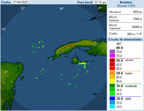
Re: NW Carribean / Southern GOM / BOC
here's a radar loop of the area appoaching the BOC.

0 likes
The following post is NOT an official forecast and should not be used as such. It is just the opinion of the poster and may or may not be backed by sound meteorological data. It is NOT endorsed by any professional institution including storm2k.org For Official Information please refer to the NHC and NWS products.
-
CYCLONE MIKE
- Category 5
- Posts: 2183
- Joined: Tue Aug 31, 2004 6:04 pm
- Location: Gonzales, LA
Re: NW Carribean / Southern GOM / BOC
I don't see this doing much of nothing in the gulf, regardless of what models show. Which by the way he been nothing but comedic since last week . Heat ridge will be flexing muscles out of the plains, hot and dry all along the gulf coast.Only escape for this system will be NE over Florida and all it will probably be is a sheared rainy mess.
Sorry tailgator talking about system in Caribbean, not yours
Sorry tailgator talking about system in Caribbean, not yours
0 likes