NW Carribean / Southern GOM / BOC (Is invest 96L)
Moderator: S2k Moderators
Forum rules

The posts in this forum are NOT official forecasts and should not be used as such. They are just the opinion of the poster and may or may not be backed by sound meteorological data. They are NOT endorsed by any professional institution or STORM2K. For official information, please refer to products from the National Hurricane Center and National Weather Service.
-
cycloneye

- Admin

- Posts: 149276
- Age: 69
- Joined: Thu Oct 10, 2002 10:54 am
- Location: San Juan, Puerto Rico
Re: NW Carribean / Southern GOM / BOC
Normally, an area with 30% in a Tropical Weather Outlook is tagged as invest,but in this case it has been difficult to pinpoint a dominant low pressure.Let's see if they can finnally tag it with a low pressure that dominates later tonight or on Thursday.
0 likes
Visit the Caribbean-Central America Weather Thread where you can find at first post web cams,radars
and observations from Caribbean basin members Click Here
and observations from Caribbean basin members Click Here
-
StormingB81

- S2K Supporter

- Posts: 5676
- Age: 44
- Joined: Thu Aug 27, 2009 1:45 am
- Location: Rockledge, Florida
-
MGC

- S2K Supporter
- Posts: 5940
- Joined: Sun Mar 23, 2003 9:05 pm
- Location: Pass Christian MS, or what is left.
Re: NW Carribean / Southern GOM / BOC
Perhaps the two lower level systems will phase and merge over the central GOM? The eastern naked swirl has quite a bit of dry air to deal with along with shear due to its proximity with the ULL over the Florida panhandle. At least the mid level low near the Yucatan is in a moisture rich enviroment and it a bit more removed from the ULLs......MGC
0 likes
-
Rgv20

- S2K Supporter
- Posts: 2466
- Age: 39
- Joined: Wed Jan 05, 2011 5:42 pm
- Location: Edinburg/McAllen Tx
Just to reiterate what Jasons said, their just too much uncertainty with this potential system. Just look at the maps below of the 18zGFS Ensembles and 12zECMWF Ensembles, their just too much chaos with their own ensemble members meaning that this is a low confidence forecast for now.
18zGFS Ensemble Means have this possible disturbance in the central gulf by Monday Night while the operational has it near Florida.
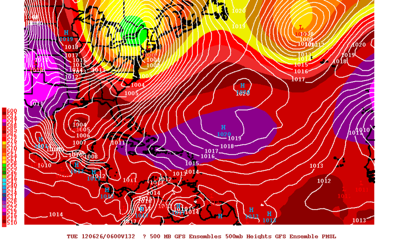
Same goes for the 12zECMWF Ensemble Means they have anywhere from the Central Gulf to crossing the Florida Peninsula on Tuesday Morning.
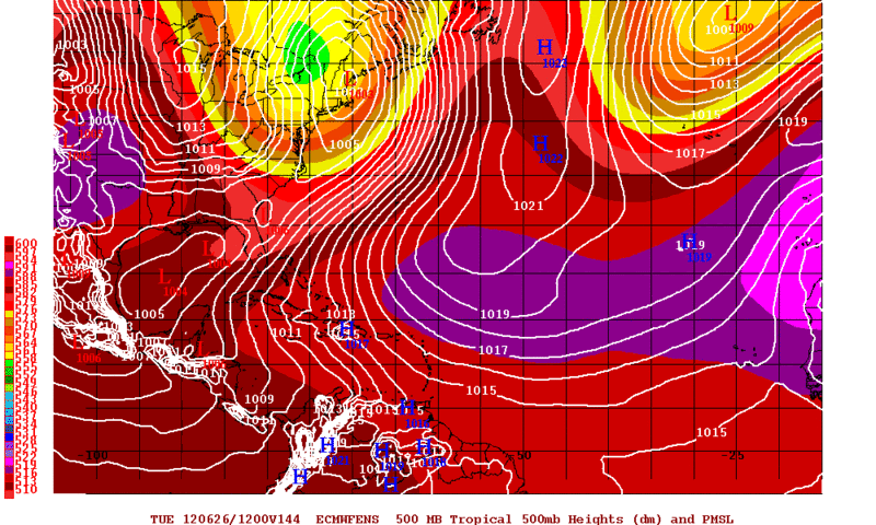
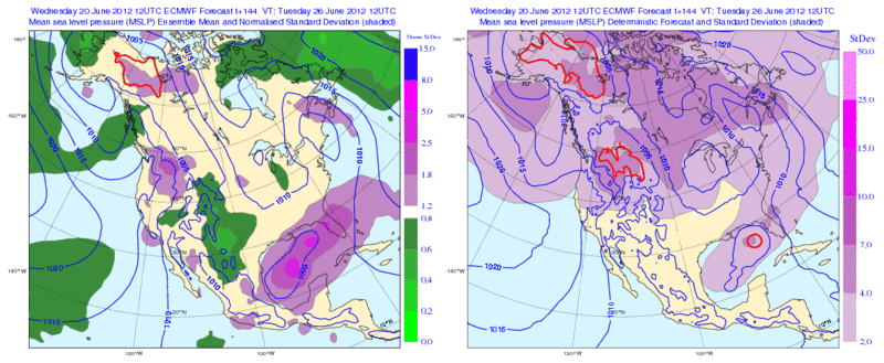
This is another image of the 12zECMWF Ensembles which represents the spread of the Members....The purple shading represents that the Ensemble Members do not agree on a forecast. In other words the darker the purple shading the lower the confidence in the forecast.
18zGFS Ensemble Means have this possible disturbance in the central gulf by Monday Night while the operational has it near Florida.
Same goes for the 12zECMWF Ensemble Means they have anywhere from the Central Gulf to crossing the Florida Peninsula on Tuesday Morning.
This is another image of the 12zECMWF Ensembles which represents the spread of the Members....The purple shading represents that the Ensemble Members do not agree on a forecast. In other words the darker the purple shading the lower the confidence in the forecast.
0 likes
The following post is NOT an official forecast and should not be used as such. It is just the opinion of the poster and may or may not be backed by sound meteorological data. It is NOT endorsed by any professional institution including storm2k.org For Official Information please refer to the NHC and NWS products.

-
floridasun78
- Category 5

- Posts: 3755
- Joined: Sun May 17, 2009 10:16 pm
- Location: miami fl
Re: NW Carribean / Southern GOM / BOC
all rain been staying off coast it try moving but staying off coast
0 likes
-
hurricanefloyd5

- Category 5
- Posts: 1659
- Age: 45
- Joined: Sun May 02, 2004 10:53 am
- Location: Spartanburg
- Contact:
Re: NW Carribean / Southern GOM / BOC
AREA FORECAST DISCUSSION
NATIONAL WEATHER SERVICE TAMPA BAY RUSKIN FL
157 PM EDT WED JUN 20 2012
LONG TERM (PREVIOUS DISCUSSION FRIDAY NIGHT-WEDNESDAY)...
NOT MUCH CHANGE TO THE ONGOING LONG TERM FORECAST. THE PERIOD STILL
BEGINS WITH A SURFACE LOW NORTH OF THE YUCATAN PENINSULA WITH
SURFACE HIGH PRESSURE OVER THE WESTERN ATLANTIC. THERE ARE STILL
SOME ONGOING DIFFERENCES BETWEEN MODEL SOLUTIONS AS FAR AS THE
EVOLUTION OF THE LOW AND THEREFORE HOW MUCH RAIN THE FORECAST AREA
WILL GET THROUGH EARLY NEXT WEEK. THE GFS IS GENERALLY THE WETTER
SOLUTION THROUGH MONDAY AS IT SHOWS THE LOW MOVING OFF THE NORTHEAST
COAST OF FLORIDA AND OUT TO SEA. THE ECMWF KEEPS MUCH OF THE RAIN
OFFSHORE UNTIL LATE SUNDAY AS THE LOW MOVES CLOSER TO THE WEST COAST
OF FLORIDA. THIS SOLUTION KEEPS US FAIRLY WET THROUGH TUESDAY WITH
THE LOW RIGHT OVER THE STATE. CONTINUED TO USE A BLEND FOR THE
FORECAST FOR NOW...BUT THERE SEEMS TO BE A GOOD CHANCE FOR SOME RAIN
ACROSS THE FORECAST AREA INTO EARLY NEXT WEEK. DEPENDING ON RAINFALL
AND CLOUD COVER...TEMPERATURES WILL RUN A FEW DEGREES COOLER IN THE
AFTERNOON.
AREA FORECAST DISCUSSION
NATIONAL WEATHER SERVICE MELBOURNE FL
345 PM EDT WED JUN 20 2012
SAT-TUE...(EDITED FROM PREVIOUS) FCST WILL HINGE ON HOW THE TROF
BEHAVES ONCE IT ENTERS THE GOMEX. PER NHC...UPR LVL WINDS MAY BECOME
A LITTLE MORE CONDUCIVE FOR DVLPMNT AS THE SYSTEM MOVES INTO THE
GULF OF MEXICO. NONETHELESS...GFS/ECMWF MODELS BOTH DLVP THE TROF
INTO A BROAD CLOSED LOW N OF THE YUCATAN CHANNEL BY 00Z SAT. BOTH
MODELS PULL THE SYSTEM ACRS THE FL PENINSULA AND OFF THE GA COAST AS
A SHORT WAVE TROF OVER THE HIGH PLAINS SWINGS THRU THE MID SOUTH
WHILE EN ROUTE TO THE MID ATLC. 12Z GFS RUN HAS TIMING THAT IS
CLOSER TO THE 00Z ECMWF RUN...WITH SYSTEM CROSSING THE FL PENINSULA
NEXT TUESDAY. A QUICK PEEK AT 12Z ECMWF INDICATES IT IS NOW TRENDING
SLOWER AND DEEPER VERSUS THE 00Z RUN...WITH THE SYSTEM STILL OVER
THE NE GULF EARLY WED. NOT MAKING CHANGES AT THIS RANGE JUST YET
GIVEN THE RUN TO RUN DISCREPANCIES.
0 likes
-
cycloneye
- Admin
- Posts: 149276
- Age: 69
- Joined: Thu Oct 10, 2002 10:54 am
- Location: San Juan, Puerto Rico
Re: NW Carribean / Southern GOM / BOC
The low west of Keys has been added to the 00z Surface Analysis.

0 likes
Visit the Caribbean-Central America Weather Thread where you can find at first post web cams,radars
and observations from Caribbean basin members Click Here
and observations from Caribbean basin members Click Here
-
Aric Dunn
- Category 5
- Posts: 21238
- Age: 43
- Joined: Sun Sep 19, 2004 9:58 pm
- Location: Ready for the Chase.
- Contact:
not surprised they added it. still surprised no invest.
0 likes
Note: If I make a post that is brief. Please refer back to previous posts for the analysis or reasoning. I do not re-write/qoute what my initial post said each time.
If there is nothing before... then just ask
Space & Atmospheric Physicist, Embry-Riddle Aeronautical University,
I believe the sky is falling...
If there is nothing before... then just ask
Space & Atmospheric Physicist, Embry-Riddle Aeronautical University,
I believe the sky is falling...

Re: NW Carribean / Southern GOM / BOC
Starting to merge already.

0 likes
The following post is NOT an official forecast and should not be used as such. It is just the opinion of the poster and may or may not be backed by sound meteorological data. It is NOT endorsed by any professional institution including storm2k.org For Official Information please refer to the NHC and NWS products.

Re: NW Carribean / Southern GOM / BOC
This could get interesting. If if becomes a tropical storm, it will be more influenced by the upper ridge.
0 likes
-
Evil Jeremy

- S2K Supporter
- Posts: 5463
- Age: 32
- Joined: Mon Apr 10, 2006 2:10 pm
- Location: Los Angeles, CA


-
South Texas Storms

- Professional-Met

- Posts: 4256
- Joined: Thu Jun 24, 2010 12:28 am
- Location: Houston, TX
Re: NW Carribean / Southern GOM / BOC
Looks like it doesn't develop much this run. And it's moving more quickly east. Less time to develop.
0 likes
-
SFLcane

- S2K Supporter
- Posts: 10281
- Age: 48
- Joined: Sat Jun 05, 2010 1:44 pm
- Location: Lake Worth Florida
Re: NW Carribean / Southern GOM / BOC
Still thinking this will not become a significant problem for anyone. More rainfall for florida for sure.
0 likes
-
Rgv20
- S2K Supporter
- Posts: 2466
- Age: 39
- Joined: Wed Jan 05, 2011 5:42 pm
- Location: Edinburg/McAllen Tx
0zGFS kicks it out of the Gulf pretty fast in this run, by Monday Evening is to the East of Florida!
0 likes
The following post is NOT an official forecast and should not be used as such. It is just the opinion of the poster and may or may not be backed by sound meteorological data. It is NOT endorsed by any professional institution including storm2k.org For Official Information please refer to the NHC and NWS products.
Re: NW Carribean / Southern GOM / BOC
SFLcane wrote:Still thinking this will not become a significant problem for anyone. More rainfall for florida for sure.
i agree. June usually = junk anyway. this probably ultimately rips east, dumps on florida as a minimal ts at best and heads out to sea. i'm not buying the western option at this point. i hope we can salvage a decent weekend around here. i want some good beach weather. as always things can change but east and weak seems like the logical bet at this point.
The posts in this forum are NOT official forecast and should not be used as such. They are just the opinion of the poster and may or may not be backed by sound meteorological data. They are NOT endorsed by any professional institution or storm2k.org. For official information, please refer to the NHC and NWS products.
0 likes
Re: NW Carribean / Southern GOM / BOC
the 0z NAM says not so fast GFS.....coming to Texas at 84hr....
http://mag.ncep.noaa.gov/NCOMAGWEB/appc ... mageSize=M
http://mag.ncep.noaa.gov/NCOMAGWEB/appc ... mageSize=M
0 likes
Re: NW Carribean / Southern GOM / BOC
ROCK wrote:the 0z NAM says not so fast GFS.....coming to Texas at 84hr....
http://mag.ncep.noaa.gov/NCOMAGWEB/appc ... mageSize=M
we'll see if the NWS introduces pops in their forecasts for tx/la in that timeframe. as of now they're dry and i suspect they'll remain so.
0 likes
-
Rgv20
- S2K Supporter
- Posts: 2466
- Age: 39
- Joined: Wed Jan 05, 2011 5:42 pm
- Location: Edinburg/McAllen Tx
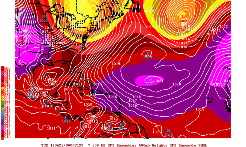
And the Operational GFS is battling with its own ensemble members...At 120hrs it still has the low in to the NW of the Yucatan while the operational has it east of Florida!
0 likes
The following post is NOT an official forecast and should not be used as such. It is just the opinion of the poster and may or may not be backed by sound meteorological data. It is NOT endorsed by any professional institution including storm2k.org For Official Information please refer to the NHC and NWS products.
Who is online
Users browsing this forum: JoshwaDone, TeamPlayersBlue, Ulf and 227 guests