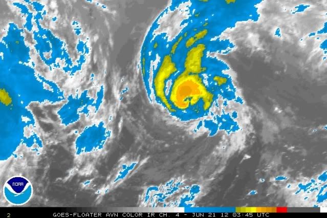
I do not usually disagree with the National Hurricane Center, but this is one of those rare cases. Infrared imagery reveals that TS Chris is obviously not a 60 mph. In fact, it's likely pushing hurricane status. Convection has been further wrapping around the eye and deepening with time. I guess we'll see what happens at 5AM EDT, but it'll probably be weakening by that time.
This is probably a post-season analysis case.
ATL: CHRIS - Post-Tropical
Moderator: S2k Moderators
-
TropicalAnalystwx13

- Category 5

- Posts: 2109
- Age: 28
- Joined: Tue Jul 19, 2011 8:20 pm
- Location: Wilmington, NC
- Contact:
-
ozonepete
- Professional-Met

- Posts: 4743
- Joined: Mon Sep 07, 2009 3:23 pm
- Location: From Ozone Park, NYC / Now in Brooklyn, NY
Re: ATL: CHRIS - Tropical Storm
Yeah, it certainly has been surprising how it keeps improving its core convective circulation over surface temps like that. I wonder if the SSTs there may be underestimated a little, since it appears to still be very tropical and doesn't appear that the convection is due to baroclinic causes.
0 likes
-
SouthDadeFish

- Professional-Met
- Posts: 2835
- Joined: Thu Sep 23, 2010 2:54 pm
- Location: Miami, FL
- Contact:
Re: ATL: CHRIS - Tropical Storm
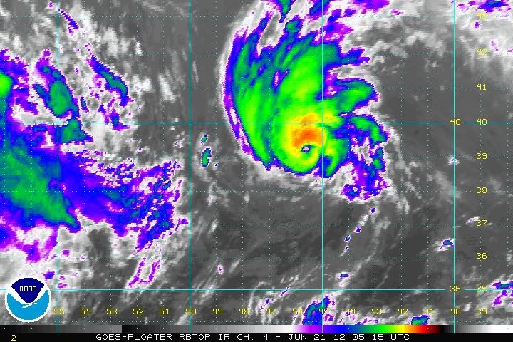
I think the case for Chris being a hurricane can be made. Satellite presentation only continues to improve:

Reminds me of Epsilon in 2005. Keeps strengthening unexpectedly.
Reminds me of Epsilon in 2005. Keeps strengthening unexpectedly.
0 likes
-
Cainer

- Tropical Storm

- Posts: 188
- Age: 34
- Joined: Mon May 05, 2008 3:26 pm
- Location: Yarmouth, Nova Scotia
I'd say even without the winds mixing fully to the surface, Chris is flirting with hurricane intensity. Convection is still deepening and wrapping around the center along with the eye becoming warmer. If it keeps it up till the 5 AM advisory, I'd say there's a decent chance the NHC will upgrade. If not, wouldn't surprise me to see it looked at in the post-season review.
My posts in this forum are NOT official forecast and should not be used as such. They are just the opinion of the poster and may or may not be backed by sound meteorological data. They are NOT endorsed by any professional institution or storm2k.org. For official information, please refer to the NHC and NWS products.
Last edited by Cainer on Thu Jun 21, 2012 12:43 am, edited 1 time in total.
0 likes

-
DanieleItalyRm

- Category 1

- Posts: 487
- Age: 40
- Joined: Mon Sep 22, 2008 7:52 am
- Location: Rome - Italy - Mediterranean sea
Very interesting CHRIS. It moves on water of 22 °C. It had a tropical transition process (extratropical->subtropical->tropical) the same process that produced many tropical cyclones over Mediterranean Sea (and Karl, Vince, Epsilon, Grace ecc).

CHRIS 50 Kt:

But 'even the recent Invest 92L May 2012 was a clear tropical storm (deserved at least subtropical), although very small; it occurred under conditions similar to CHRIS...


CHRIS 50 Kt:

But 'even the recent Invest 92L May 2012 was a clear tropical storm (deserved at least subtropical), although very small; it occurred under conditions similar to CHRIS...


Last edited by DanieleItalyRm on Thu Jun 21, 2012 5:24 am, edited 4 times in total.
0 likes
-
brunota2003

- S2K Supporter

- Posts: 9476
- Age: 35
- Joined: Sat Jul 30, 2005 9:56 pm
- Location: Stanton, KY...formerly Havelock, NC
- Contact:
When was the last time anyone saw a 50 knot tropical storm that had a fully formed eye for over 12 hours?
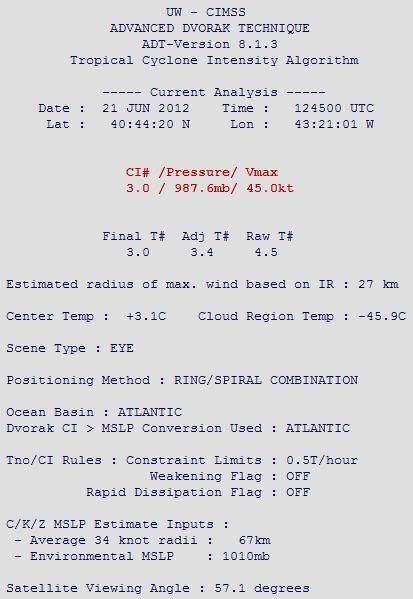
And of course...ADT keeps going with a curved band scene type, and keeps putting the center marker well to the west of the eye (going off of forecast interpretation)...
And of course...ADT keeps going with a curved band scene type, and keeps putting the center marker well to the west of the eye (going off of forecast interpretation)...
0 likes
Just a small town southern boy helping other humans.
-
cycloneye

- Admin

- Posts: 149275
- Age: 69
- Joined: Thu Oct 10, 2002 10:54 am
- Location: San Juan, Puerto Rico
Re: ATL: CHRIS - Tropical Storm
TROPICAL STORM CHRIS DISCUSSION NUMBER 7
NWS NATIONAL HURRICANE CENTER MIAMI FL AL032012
500 AM AST THU JUN 21 2012
CHRIS HAS MAINTAINED AN EYE-LIKE FEATURE SURROUNDED BY A RING OF
CONVECTION WITH CLOUD TOP TEMPERATURES OF -50C TO -60C DURING THE
PAST FEW HOURS. SUBJECTIVE AND OBJECTIVE DVORAK T-NUMBERS ARE
ESSENTIALLY UNCHANGED SINCE THE LAST ADVISORY AND DO NOT SUPPORT A
HIGHER INTENSITY...SO THE INITIAL INTENSITY IS KEPT AT 50 KT. EVEN
IF CHRIS IS STRONGER THAN ESTIMATED...THE PASSAGE OF THE CYCLONE
OVER SUB-22C SEA SURFACE TEMPERATURES COULD BE INHIBITING AN
EFFICIENT CONVECTIVE TRANSPORT OF THE STRONGEST WINDS TO THE
OCEAN SURFACE.
THE INITIAL MOTION IS 065/17...WHICH IS A BIT SLOWER AND TO THE LEFT
OF THE PREVIOUS ESTIMATE. CHRIS IS EXPECTED TO TURN NORTH-
NORTHEASTWARD AND THEN NORTHWARD AS IT DECELERATES AND DUMBBELLS
CYCLONICALLY AROUND A LARGE MID- TO UPPER-LEVEL LOW FORECAST TO CUT
OFF SOUTHEAST OF THE CANADIAN MARITIME PROVINCES DURING THE NEXT
24-36 HOURS. MODEL GUIDANCE GENERALLY SHOWS CHRIS BEING ABSORBED BY
THIS WEATHER FEATURE IN 36-48 HOURS...WITH THE NEW ENTITY
COMPLETING A CYCLONIC LOOP AND THEN MOVING EASTWARD TO EAST-
NORTHEASTWARD OVER THE FAR NORTH ATLANTIC. GLOBAL MODELS ARE IN
GOOD AGREEMENT WITH REGARD TO THIS SCENARIO...AND THE TRACK
FORECAST IS BASICALLY AN UPDATE OF THE PREVIOUS ONE.
DESPITE THE FACT THAT CHRIS IS MOVING OVER RATHER COOL WATERS...
A 0505 UTC AMSU PASSES STILL SHOWED THE PRESENCE OF A WELL-DEFINED
MODERATE TO DEEP WARM CORE IN ASSOCIATION WITH THE CYCLONE.
ALTHOUGH CHRIS IS EXPECTED TO MAINTAIN WARM-CORE CHARACTERISTICS
DURING THE NEXT 24 HOURS OR SO...IT COULD LOSE ITS DEEP CONVECTION
WHILE MOVING OVER EVEN COOLER WATERS AND BE DECLARED POST-TROPICAL.
SHOULD IT MAINTAIN DEEP CONVECTION LONGER...EITHER ITS INTERACTION
WITH A LOW-LEVEL BAROCLINIC ZONE TO THE NORTH AND/OR ITS
INTERACTION WITH THE CUT-OFF LOW TO ITS WEST SHOULD RESULT IN
EXTRATROPICAL TRANSITION IN ABOUT 36 HOURS.
FORECAST POSITIONS AND MAX WINDS
INIT 21/0900Z 39.9N 44.8W 50 KT 60 MPH
12H 21/1800Z 41.6N 43.1W 50 KT 60 MPH
24H 22/0600Z 43.6N 43.0W 50 KT 60 MPH...POST-TROPICAL
36H 22/1800Z 44.3N 44.8W 45 KT 50 MPH...POST-TROP/EXTRATROP
48H 23/0600Z 43.0N 46.5W 40 KT 45 MPH...POST-TROP/EXTRATROP
72H 24/0600Z...ABSORBED BY ANOTHER EXTRATROPICAL LOW
$$
FORECASTER KIMBERLAIN
0 likes
Visit the Caribbean-Central America Weather Thread where you can find at first post web cams,radars
and observations from Caribbean basin members Click Here
and observations from Caribbean basin members Click Here
-
cycloneye
- Admin
- Posts: 149275
- Age: 69
- Joined: Thu Oct 10, 2002 10:54 am
- Location: San Juan, Puerto Rico
Re: ATL: CHRIS - Tropical Storm
Hurricane Chris on 12z Best Track
AL, 03, 2012062112, , BEST, 0, 405N, 439W, 65, 987, HU
http://ftp.nhc.noaa.gov/atcf/tcweb/inve ... 012.invest
AL, 03, 2012062112, , BEST, 0, 405N, 439W, 65, 987, HU
http://ftp.nhc.noaa.gov/atcf/tcweb/inve ... 012.invest
0 likes
Visit the Caribbean-Central America Weather Thread where you can find at first post web cams,radars
and observations from Caribbean basin members Click Here
and observations from Caribbean basin members Click Here
-
Aric Dunn
- Category 5
- Posts: 21238
- Age: 43
- Joined: Sun Sep 19, 2004 9:58 pm
- Location: Ready for the Chase.
- Contact:
about time. must of been some ship report. because the discussion really sounded like they were not going to upgrade.
0 likes
Note: If I make a post that is brief. Please refer back to previous posts for the analysis or reasoning. I do not re-write/qoute what my initial post said each time.
If there is nothing before... then just ask
Space & Atmospheric Physicist, Embry-Riddle Aeronautical University,
I believe the sky is falling...
If there is nothing before... then just ask
Space & Atmospheric Physicist, Embry-Riddle Aeronautical University,
I believe the sky is falling...

-
northjaxpro

- S2K Supporter
- Posts: 8900
- Joined: Mon Sep 27, 2010 11:21 am
- Location: Jacksonville, FL
Amazing that the first designated cane of the season developed that far north in the Atlantic. Also, I can't wait to see the post-season analysis from NHC. I still think there is a possibility Beryl will be classified as a minimal hurricane as well.
0 likes
NEVER, EVER SAY NEVER in the tropics and weather in general, and most importantly, with life itself!!
________________________________________________________________________________________
Fay 2008 Beryl 2012 Debby 2012 Colin 2016 Hermine 2016 Julia 2016 Matthew 2016 Irma 2017 Dorian 2019
________________________________________________________________________________________
Fay 2008 Beryl 2012 Debby 2012 Colin 2016 Hermine 2016 Julia 2016 Matthew 2016 Irma 2017 Dorian 2019
-
ozonepete
- Professional-Met
- Posts: 4743
- Joined: Mon Sep 07, 2009 3:23 pm
- Location: From Ozone Park, NYC / Now in Brooklyn, NY
Re:
brunota2003 wrote:When was the last time anyone saw a 50 knot tropical storm that had a fully formed eye for over 12 hours?
And of course...ADT keeps going with a curved band scene type, and keeps putting the center marker well to the west of the eye (going off of forecast interpretation)...
Very good point my friend. I was wondering why their numbers were so low but didn't get a chance to look at the analysis until now. Wonder if they realized what was going on and that had something to do with the upgrade as well...
0 likes

Awww...too bad...I was hoping we could make a run for beating last year's record of the msot tropical storms without a hurricane  (If Debby forms in the Gulf, in my opinion...not official...I don't think it will be a hurricane). But yeah, it looks stronger than 60 mph...like an Epsilon or other late season storms.
0 likes
-
ozonepete
- Professional-Met
- Posts: 4743
- Joined: Mon Sep 07, 2009 3:23 pm
- Location: From Ozone Park, NYC / Now in Brooklyn, NY
Re: ATL: CHRIS - Tropical Storm
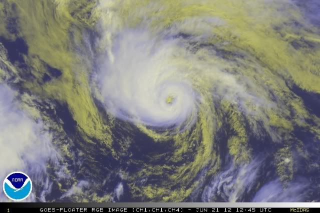
Really nice presentation on satellite. And it made hurricane just in the nick of time. You can't believe it will be able to hang onto such a good convective core for much longer given those water temps.
0 likes
What a weird hurricane. But it looks like it would be hard to argue about it. A nice outflow band to the north, deep convection encircling a beautiful eye, and for a system north of 40 degrees. Just wow.
0 likes
I'm no expert, everything I say should be taken with a large amount of salt. I could easily be very, very wrong.
~Zanthe Go Coyotes~
~Zanthe Go Coyotes~
-
ozonepete
- Professional-Met
- Posts: 4743
- Joined: Mon Sep 07, 2009 3:23 pm
- Location: From Ozone Park, NYC / Now in Brooklyn, NY
Re: Re:
ozonepete wrote:brunota2003 wrote:When was the last time anyone saw a 50 knot tropical storm that had a fully formed eye for over 12 hours?
And of course...ADT keeps going with a curved band scene type, and keeps putting the center marker well to the west of the eye (going off of forecast interpretation)...
Very good point my friend. I was wondering why their numbers were so low but didn't get a chance to look at the analysis until now. Wonder if they realized what was going on and that had something to do with the upgrade as well...
And there you go: CIMSS just changed the positioning method to RING/SPIRAL COMBINATION and - BINGO! - the program has found the center! Notice how the raw T# jumped to 4.5 from a 3. Shows how important the initialization type is.
0 likes
-
hurricaneCW
- Category 5
- Posts: 1799
- Joined: Wed Mar 03, 2010 6:20 am
- Location: Toms River, NJ
Re: ATL: CHRIS - Tropical Storm
Chris looks better than many storms existing in the deep tropics.
0 likes
-
brunota2003
- S2K Supporter
- Posts: 9476
- Age: 35
- Joined: Sat Jul 30, 2005 9:56 pm
- Location: Stanton, KY...formerly Havelock, NC
- Contact:
Who is online
Users browsing this forum: No registered users and 28 guests