ATL: DEBBY - Post-Tropical

Moderator: S2k Moderators

Message
Author
User avatar
cycloneye
Admin
Admin
Posts: 145351
Age: 68
Joined: Thu Oct 10, 2002 10:54 am
Location: San Juan, Puerto Rico

Re: ATL: INVEST 96L - Discussion

#841 Postby cycloneye » Fri Jun 22, 2012 6:25 pm

Tropical Cyclone Formation Alert

I didn't saw it posted this afternoon so here it is.

SUBJ/TROPICAL CYCLONE FORMATION ALERT//
WTNT21 KNGU 221600
RMKS/
1. FORMATION OF A SIGNIFICANT TROPICAL CYCLONE IS POSSIBLE WITHIN
100 NM EITHER SIDE OF A LINE FROM 22.6N 88.3W TO 26.0N 88.3W
WITHIN THE NEXT 12 TO 24 HOURS. AVAILABLE DATA DOES NOT JUSTIFY
ISSUANCE OF NUMBERED TROPICAL CYCLONE WARNINGS AT THIS TIME.
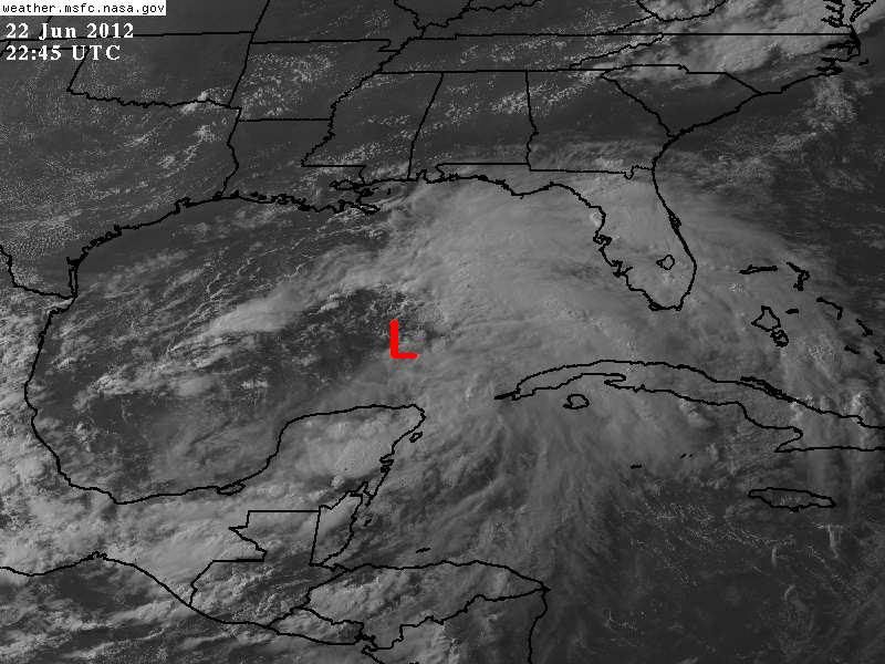
WINDS IN THE AREA ARE ESTIMATED TO BE 20 TO 25 KNOTS. METSAT
IMAGERY AT 221545Z INDICATES THAT A CIRCULATION CENTER IS LOCATED
NEAR 22.5N 88.3W. THE SYSTEM IS MOVING NORTHWARD AT 02 KNOTS.
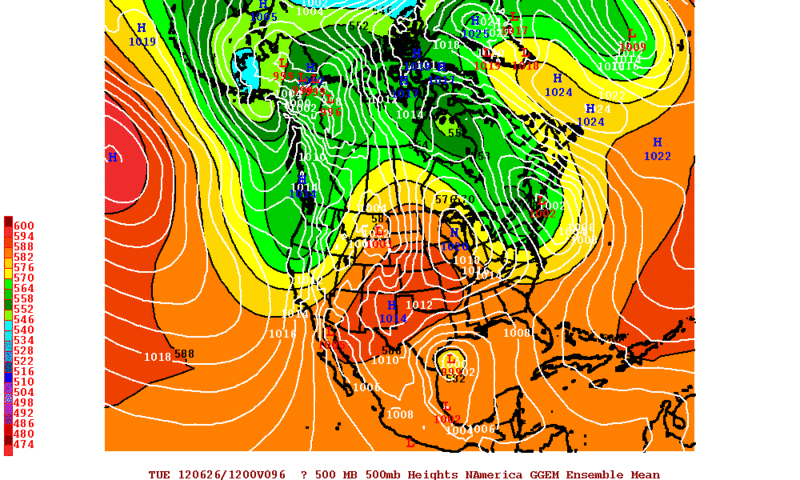
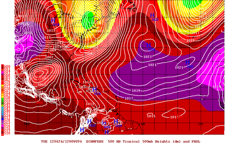
2. REMARKS:CURRENT MODEL GUIDANCE IS DEPICTING INTENSIFICATION
OF A TROPICAL WAVE OVER THE YUCATAN PENINSULA. AT 221544Z,
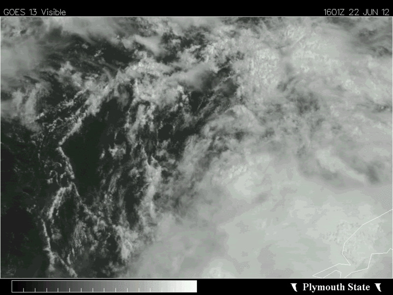
INFRARED SATELLITE IMAGERY INDICATED A BROAD AREA OF
SHOWERS/THUNDERSTORMS THAT HAS PERSISTED FOR OVER 12 HOURS.
FAVORABLE SEA SURFACE TEMPERATURES OF 83 TO 85 DEGREES FAHRENHEIT
IN CONJUNCTION WITH WEAK VERTICAL SHEAR MAY ENHANCE DEVELOPMENT OF
THIS SYTEM INTO A TROPICAL CYCLONE OVER THE NEXT 24 HOURS.
3. THIS ALERT WILL BE REISSUED, UPGRADED TO WARNING OR CANCELLED
BY 231600Z.//

Image
0 likes   
Visit the Caribbean-Central America Weather Thread where you can find at first post web cams,radars
and observations from Caribbean basin members Click Here

User avatar
ROCK
Category 5
Category 5
Posts: 9484
Age: 54
Joined: Tue Aug 17, 2004 7:30 am
Location: Kemah, Texas

Re: ATL: INVEST 96L - Discussion

#842 Postby ROCK » Fri Jun 22, 2012 6:29 pm

Last edited by ROCK on Fri Jun 22, 2012 6:31 pm, edited 1 time in total.
0 likes   

User avatar
NDG
S2K Supporter
S2K Supporter
Posts: 15446
Joined: Sun Jul 09, 2006 10:14 pm
Location: Orlando, FL

Re: Re:

#843 Postby NDG » Fri Jun 22, 2012 6:30 pm

TheShrimper wrote:
NDG wrote:So far this is the best surface vorticity that 96L has spit out, perhaps it could become the dominant circulation.
http://i20.photobucket.com/albums/b245/ ... 840_an.gif


Where would you put that at NDG ?


Near 24N & 87.7W
0 likes   

User avatar
Rgv20
S2K Supporter
S2K Supporter
Posts: 2466
Age: 38
Joined: Wed Jan 05, 2011 5:42 pm
Location: Edinburg/McAllen Tx

#844 Postby Rgv20 » Fri Jun 22, 2012 6:30 pm

12zCMC Ensembles and 12zECMWF Ensembles favor the Western Gulf.....Its hard to go against the ECMWF Ensembles, IMO this possible TC more than likely is going to pose a threat to the Western Gulf. FWIW the 12zECMWF EPS Control Run has it making landfall about 50 to 75 miles south of Brownsville on Wednesday Evening while the Operational run has on top of Brownsville. Do not be surprise if the Euro trends a little further south in future runs.

12zCMC Ensemble Means Forecast Valid for Tuesday Morning....TC off the South Texas Coast.
Image

12zECMWF Ensemble Means Forecast Valid for Tuesday Morning....TC just SE of Brownsville.
Image
Last edited by Rgv20 on Fri Jun 22, 2012 6:39 pm, edited 1 time in total.
0 likes   
The following post is NOT an official forecast and should not be used as such. It is just the opinion of the poster and may or may not be backed by sound meteorological data. It is NOT endorsed by any professional institution including storm2k.org For Official Information please refer to the NHC and NWS products.

User avatar
NDG
S2K Supporter
S2K Supporter
Posts: 15446
Joined: Sun Jul 09, 2006 10:14 pm
Location: Orlando, FL

#845 Postby NDG » Fri Jun 22, 2012 6:32 pm

Compared to this morning it looks way better, with an impressive outflow on its eastern quadrant, quite a big circulation, no wonder is taking so long to get going.

I placed the L over where that possible LLC is getting going.

Image
0 likes   

User avatar
MGC
S2K Supporter
S2K Supporter
Posts: 5899
Joined: Sun Mar 23, 2003 9:05 pm
Location: Pass Christian MS, or what is left.

Re: ATL: INVEST 96L - Discussion

#846 Postby MGC » Fri Jun 22, 2012 6:34 pm

"Patience Grasshopper"

96L is a large disturbance. These large disturbances sometimes take quite a while to consolidate. I've witnessed this scenario unfold many times in my 45+ years of tracking hurricanes. The low north of the Yucatan is going to slowly lift north and acquire more convection. I'm going with a general northward motion with a turn to the west. The trough looks to have made its way about as far south as it is going to get and 96L is going to miss it. The ridge will build back from the Atlantic and push the system westward with time. It may take until late Sunday or Monday for the system to be named.....MGC

The above is the opinion of MGC and not an official forecast.
0 likes   

User avatar
SEASON_CANCELED
Category 3
Category 3
Posts: 887
Joined: Mon Jul 06, 2009 5:17 am
Location: 8 Bit Charlie Sheen

Re: ATL: INVEST 96L - Models

#847 Postby SEASON_CANCELED » Fri Jun 22, 2012 6:36 pm

What sort of intensity are we looking at? Which model is the best for intesity? Im having trouble believing the GFS and CMC doomsday models. Tis the season
0 likes   
i am a big stupid ugly moron with an ugly face and a big butt and my butt stinks and i like to kiss my own butt

User avatar
SouthDadeFish
Professional-Met
Professional-Met
Posts: 2835
Joined: Thu Sep 23, 2010 2:54 pm
Location: Miami, FL
Contact:

#848 Postby SouthDadeFish » Fri Jun 22, 2012 6:37 pm

I think it is starting to slowly wrap up. 21Z Vorticity analysis from CIMSS shows that the vort maxes are finally starting to consolidate off the tip of the NE Yucatan. Also, the mid and low level vort centers are becoming better aligned. It will be interesting to see what the 00Z analysis shows. I wouldn't be surprised to see the NHC give it 80% at 8pm.
0 likes   

TheShrimper
Category 2
Category 2
Posts: 516
Joined: Sun Aug 01, 2004 5:05 pm

Re: Re:

#849 Postby TheShrimper » Fri Jun 22, 2012 6:41 pm

NDG wrote:
TheShrimper wrote:
NDG wrote:So far this is the best surface vorticity that 96L has spit out, perhaps it could become the dominant circulation.
http://i20.photobucket.com/albums/b245/ ... 840_an.gif


Where would you put that at NDG ?


Near 24N & 87.7W


Better check again. 24N isn't even in the running and 87.7W is not even close to the focal point in the Vis. Loop you provided. Just my take on what stood out in the Vis.
0 likes   

User avatar
cycloneye
Admin
Admin
Posts: 145351
Age: 68
Joined: Thu Oct 10, 2002 10:54 am
Location: San Juan, Puerto Rico

Re: ATL: INVEST 96L - Discussion

#850 Postby cycloneye » Fri Jun 22, 2012 6:45 pm

Up to 80%

TROPICAL WEATHER OUTLOOK
NWS NATIONAL HURRICANE CENTER MIAMI FL
800 PM EDT FRI JUN 22 2012

FOR THE NORTH ATLANTIC...CARIBBEAN SEA AND THE GULF OF MEXICO...

SATELLITE IMAGERY AND SURFACE OBSERVATIONS INDICATE THAT THE
CIRCULATION ASSOCIATED WITH THE LARGE SURFACE LOW PRESSURE AREA
LOCATED ABOUT 100 MILES NORTH OF THE NORTHEASTERN TIP OF THE
YUCATAN PENINSULA HAS CONTINUED TO BECOME BETTER DEFINED. SURFACE
PRESSURES ARE STILL FALLING ACROSS THE AREA...AND SHOWER AND
THUNDERSTORM ACTIVITY HAS BEEN STEADILY INCREASING OVER MUCH OF THE
CENTRAL AND EASTERN GULF OF MEXICO TODAY. ENVIRONMENTAL CONDITIONS
ARE EXPECTED TO REMAIN CONDUCIVE FOR A TROPICAL DEPRESSION TO FORM
DURING THE NEXT DAY OR SO AS THIS LARGE DISTURBANCE DRIFTS SLOWLY
NORTHWARD. THIS SYSTEM HAS A HIGH CHANCE...80 PERCENT...OF BECOMING
A TROPICAL CYCLONE DURING THE NEXT 48 HOURS. INTERESTS ALONG THE
UNITED STATES GULF COAST SHOULD MONITOR THE PROGRESS OF THIS
DISTURBANCE THROUGH THE WEEKEND. HEAVY RAINS AND LOCALIZED FLOODING
ARE POSSIBLE ACROSS THE YUCATAN PENINSULA...WESTERN CUBA...AND
SOUTHERN FLORIDA THROUGH SATURDAY.

ELSEWHERE...TROPICAL CYCLONE FORMATION IS NOT EXPECTED DURING THE
NEXT 48 HOURS.

$$
FORECASTER STEWART
0 likes   
Visit the Caribbean-Central America Weather Thread where you can find at first post web cams,radars
and observations from Caribbean basin members Click Here

Steve H.
Category 5
Category 5
Posts: 2146
Joined: Sat Oct 19, 2002 9:06 am
Location: Palm Bay, Florida

Re: ATL: INVEST 96L - Discussion

#851 Postby Steve H. » Fri Jun 22, 2012 6:47 pm

I believe that the center is further east than where 96L is shown. That small vorticity is spinning off to the west. The center is firing up just to the west of western Cuba. Not saying that will change the ultimate outcome of where it will go - but the center is further east then is shown on the map.
0 likes   

User avatar
TropicalAnalystwx13
Category 5
Category 5
Posts: 2109
Age: 27
Joined: Tue Jul 19, 2011 8:20 pm
Location: Wilmington, NC
Contact:

#852 Postby TropicalAnalystwx13 » Fri Jun 22, 2012 6:50 pm

Lol, my post was removed so somebody else repost it?
0 likes   

User avatar
cycloneye
Admin
Admin
Posts: 145351
Age: 68
Joined: Thu Oct 10, 2002 10:54 am
Location: San Juan, Puerto Rico

Re:

#853 Postby cycloneye » Fri Jun 22, 2012 6:51 pm

TropicalAnalystwx13 wrote:Lol, my post was removed so somebody else repost it?


The TWO was already here when you posted it.
0 likes   
Visit the Caribbean-Central America Weather Thread where you can find at first post web cams,radars
and observations from Caribbean basin members Click Here

TheShrimper
Category 2
Category 2
Posts: 516
Joined: Sun Aug 01, 2004 5:05 pm

Re: ATL: INVEST 96L - Discussion

#854 Postby TheShrimper » Fri Jun 22, 2012 6:53 pm

Steve H. wrote:I believe that the center is further east than where 96L is shown. That small vorticity is spinning off to the west. The center is firing up just to the west of western Cuba. Not saying that will change the ultimate outcome of where it will go - but the center is further east then is shown on the map.


That's what I see Steve, and you haven't been drinking all day like I have. I've got it closer to 86.0W give or take a few fifth's.... I mean tenths.
0 likes   

User avatar
Portastorm
Storm2k Moderator
Storm2k Moderator
Posts: 9914
Age: 63
Joined: Fri Jul 11, 2003 9:16 am
Location: Round Rock, TX
Contact:

Re: ATL: INVEST 96L - Discussion

#855 Postby Portastorm » Fri Jun 22, 2012 6:57 pm

TheShrimper wrote:
Steve H. wrote:I believe that the center is further east than where 96L is shown. That small vorticity is spinning off to the west. The center is firing up just to the west of western Cuba. Not saying that will change the ultimate outcome of where it will go - but the center is further east then is shown on the map.


That's what I see Steve, and you haven't been drinking all day like I have. I've got it closer to 86.0W give or take a few fifth's.... I mean tenths.


Alright Shrimper ... we get it. You've been drinking all day. Now, let's focus our posts on 96L, shall we? Thanks.
0 likes   
Any forecasts under my name are to be taken with a grain of salt. Get your best forecasts from the National Weather Service and National Hurricane Center.

User avatar
Evil Jeremy
S2K Supporter
S2K Supporter
Posts: 5463
Age: 32
Joined: Mon Apr 10, 2006 2:10 pm
Location: Los Angeles, CA

#856 Postby Evil Jeremy » Fri Jun 22, 2012 6:57 pm

18z GFDL is somewhat Texas bound. The model looses the storm in the Gulf but sends the leftover energy west:

http://moe.met.fsu.edu/cgi-bin/gfdltc2. ... =Animation
0 likes   
Frances 04 / Jeanne 04 / Katrina 05 / Wilma 05 / Fay 08 / Debby 12 / Andrea 13 / Colin 16 / Hermine 16 / Matthew 16 / Irma 17

User avatar
cycloneye
Admin
Admin
Posts: 145351
Age: 68
Joined: Thu Oct 10, 2002 10:54 am
Location: San Juan, Puerto Rico

Re:

#857 Postby cycloneye » Fri Jun 22, 2012 6:59 pm

Evil Jeremy wrote:18z GFDL is somewhat Texas bound. The model looses the storm in the Gulf but sends the leftover energy west:

http://moe.met.fsu.edu/cgi-bin/gfdltc2. ... =Animation


Ummm a change in track.
0 likes   
Visit the Caribbean-Central America Weather Thread where you can find at first post web cams,radars
and observations from Caribbean basin members Click Here

User avatar
Hurricane Andrew
S2K Supporter
S2K Supporter
Posts: 1891
Age: 26
Joined: Sun May 23, 2010 2:53 pm
Location: KS

#858 Postby Hurricane Andrew » Fri Jun 22, 2012 7:02 pm

If you look at the VIS loop, anyone think there is a low in the centerish of the convection, at about 22.8N 86W? It's messy down there.

http://www.ssd.noaa.gov/PS/TROP/floater ... short.html
0 likes   

The Enthusiast
NREMT-AEMT, WX nerd

Irene '11, Sandy '12, Irma '17 (SAR)

"Hard to think we were born to live this way..." -Wage War

User avatar
Evil Jeremy
S2K Supporter
S2K Supporter
Posts: 5463
Age: 32
Joined: Mon Apr 10, 2006 2:10 pm
Location: Los Angeles, CA

Re: Re:

#859 Postby Evil Jeremy » Fri Jun 22, 2012 7:05 pm

cycloneye wrote:
Evil Jeremy wrote:18z GFDL is somewhat Texas bound. The model looses the storm in the Gulf but sends the leftover energy west:

http://moe.met.fsu.edu/cgi-bin/gfdltc2. ... =Animation


Ummm a change in track.


Yep. Now we await the 18z HWRF, lets see if it sticks by big brother GFS.
0 likes   
Frances 04 / Jeanne 04 / Katrina 05 / Wilma 05 / Fay 08 / Debby 12 / Andrea 13 / Colin 16 / Hermine 16 / Matthew 16 / Irma 17

User avatar
Hurricane Andrew
S2K Supporter
S2K Supporter
Posts: 1891
Age: 26
Joined: Sun May 23, 2010 2:53 pm
Location: KS

#860 Postby Hurricane Andrew » Fri Jun 22, 2012 7:07 pm

Guys, that 4 panel HRW you post, where can I get that?
0 likes   

The Enthusiast
NREMT-AEMT, WX nerd

Irene '11, Sandy '12, Irma '17 (SAR)

"Hard to think we were born to live this way..." -Wage War


Return to “2012”

Who is online

Users browsing this forum: No registered users and 4 guests