ATL: DEBBY - Post-Tropical
Moderator: S2k Moderators

Re: ATL: INVEST 96L - Models
[quote="Ivanhater"]CMC looks like Louisiana/Texas border....
Northern shift....however, look how close it gets to the New Orleans
it had a similar run a few days ago....
Northern shift....however, look how close it gets to the New Orleans
it had a similar run a few days ago....
0 likes


Re: ATL: INVEST 96L - Discussion
JonathanBelles wrote:The models remain split down the middle, but hurricane hunters will investigate tomorrow afternoon. 3-4" of rain expected on the Florida gulf coast. What made the NHC bump it up the 80%, and what happens after 24 hours?
http://jonathanbelles.wordpress.com/201 ... continues/

How do they tell difference between mid-level and low-level circulation.
0 likes
-
Hurricaneman

- Category 5

- Posts: 7404
- Age: 45
- Joined: Tue Aug 31, 2004 3:24 pm
- Location: central florida
Re: ATL: INVEST 96L - Models
CMC still prefers the west solution for sure....that 6 runs now...EURO might clear some things up...
0 likes
-
Stormcenter
- S2K Supporter

- Posts: 6685
- Joined: Wed Sep 03, 2003 11:27 am
- Location: Houston, TX
IMO it's pretty easy to see where the center is trying form....shear is still an issue for it.
http://www.ssd.noaa.gov/goes/east/gmex/flash-ir2.html
http://www.ssd.noaa.gov/goes/east/gmex/flash-ir2.html
0 likes
-
Ivanhater

- Storm2k Moderator

- Posts: 11166
- Age: 38
- Joined: Fri Jul 01, 2005 8:25 am
- Location: Pensacola
Re: ATL: INVEST 96L - Models
ROCK wrote:CMC still prefers the west solution for sure....that 6 runs now...EURO might clear some things up...
Even if the models stay the same..they GFS and TVCN still are split and we are in the same boat.But the NHC will have to issue a track at some point
0 likes
Michael
-
Rgv20

- S2K Supporter
- Posts: 2466
- Age: 39
- Joined: Wed Jan 05, 2011 5:42 pm
- Location: Edinburg/McAllen Tx
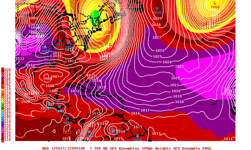
0zGFS Ensemble means show a very weak signal of the low in the Western Gulf due east of Brownsville by Wednesday Morning.....This is going to be such a delicate forecast!
0 likes
The following post is NOT an official forecast and should not be used as such. It is just the opinion of the poster and may or may not be backed by sound meteorological data. It is NOT endorsed by any professional institution including storm2k.org For Official Information please refer to the NHC and NWS products.
-
HouTXmetro

- Category 5
- Posts: 3949
- Joined: Sun Jun 13, 2004 6:00 pm
- Location: District of Columbia, USA
-
Rgv20
- S2K Supporter
- Posts: 2466
- Age: 39
- Joined: Wed Jan 05, 2011 5:42 pm
- Location: Edinburg/McAllen Tx
Re: ATL: INVEST 96L - Models
Ivanhater wrote:Ukie is a northern shift
The UKMET moves it NW from 96hrs to 120hrs, I cant see that happening since the west coast trough should flatten out the ridge and keep moving whatever is in the Gulf west.....Orientation of the Ridge is going to be crucial.
0 likes
The following post is NOT an official forecast and should not be used as such. It is just the opinion of the poster and may or may not be backed by sound meteorological data. It is NOT endorsed by any professional institution including storm2k.org For Official Information please refer to the NHC and NWS products.
-
Janie2006

- Category 5
- Posts: 1329
- Joined: Mon Sep 18, 2006 3:28 pm
- Location: coastal Ms aka home of the hurricanes
Re: ATL: INVEST 96L - Models
Invest 96 Blob is giving me a headache. I can easily see a scenario in which it does nothing but sloshes around the GOM for a few days, for example. Sooner or later one of the big players has to make a move, but in the meantime...let the model madness continue.
0 likes
-
Hurricaneman
- Category 5
- Posts: 7404
- Age: 45
- Joined: Tue Aug 31, 2004 3:24 pm
- Location: central florida
Re: ATL: INVEST 96L - Models
The GFS Ensembles look to be like a split between the eastern solution into Florida and the other half have it going to Texas if Im reading this right so no real consensus
The posts in this forum are NOT official forecast and should not be used as such. They are just the opinion of the poster and may or may not be backed by sound meteorological data. They are NOT endorsed by any professional institution or storm2k.org. For official information, please refer to the NHC and NWS products
The posts in this forum are NOT official forecast and should not be used as such. They are just the opinion of the poster and may or may not be backed by sound meteorological data. They are NOT endorsed by any professional institution or storm2k.org. For official information, please refer to the NHC and NWS products
0 likes
-
Ivanhater
- Storm2k Moderator
- Posts: 11166
- Age: 38
- Joined: Fri Jul 01, 2005 8:25 am
- Location: Pensacola
Re: ATL: INVEST 96L - Models
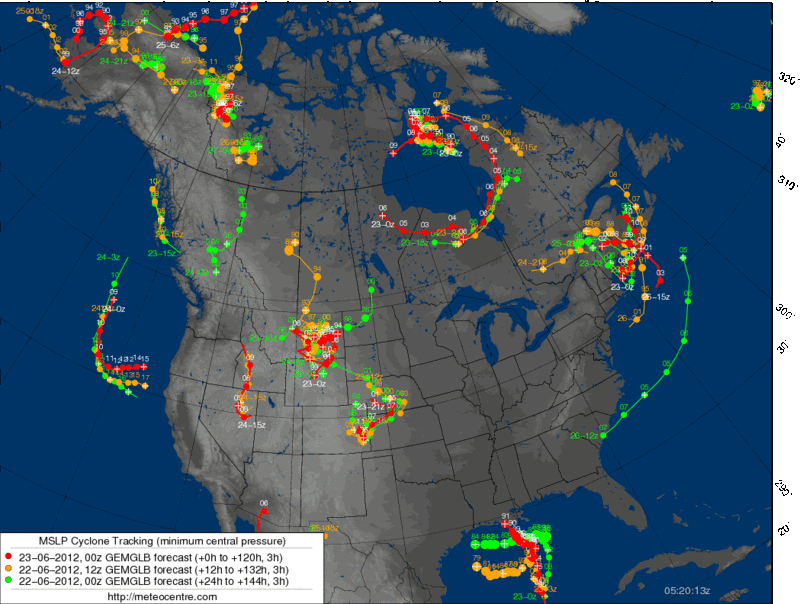
Actually...00z Canadian is a big shift east...takes it into central Louisiana then north into Arkansas


0 likes
Michael
-
Kingarabian

- S2K Supporter
- Posts: 16282
- Joined: Sat Aug 08, 2009 3:06 am
- Location: Honolulu, Hawaii

-
HouTXmetro
- Category 5
- Posts: 3949
- Joined: Sun Jun 13, 2004 6:00 pm
- Location: District of Columbia, USA
-
Hurricaneman
- Category 5
- Posts: 7404
- Age: 45
- Joined: Tue Aug 31, 2004 3:24 pm
- Location: central florida
Re:
HouTXmetro wrote:So if the storm splits the difference and heads into Louisiana, which models do we declare the victor? lol
The Canadian model would be pretty close in that reguard
0 likes
-
Rgv20
- S2K Supporter
- Posts: 2466
- Age: 39
- Joined: Wed Jan 05, 2011 5:42 pm
- Location: Edinburg/McAllen Tx
The Past three runs of the CMC
0 likes
The following post is NOT an official forecast and should not be used as such. It is just the opinion of the poster and may or may not be backed by sound meteorological data. It is NOT endorsed by any professional institution including storm2k.org For Official Information please refer to the NHC and NWS products.
Who is online
Users browsing this forum: No registered users and 21 guests