http://derecho.math.uwm.edu/models/al962012.png
ATL: DEBBY - Post-Tropical
Moderator: S2k Moderators
-
Dean4Storms
- S2K Supporter

- Posts: 6358
- Age: 63
- Joined: Sun Aug 31, 2003 1:01 pm
- Location: Miramar Bch. FL
-
Portastorm

- Storm2k Moderator

- Posts: 9955
- Age: 63
- Joined: Fri Jul 11, 2003 9:16 am
- Location: Round Rock, TX
- Contact:
Re: ATL: INVEST 96L - Discussion
lrak wrote:Is there an ULL forming over SE TX? Will that help to stear it towards Florida? And do you guys see any swells likely for the TX coast? It seems to far North for a TX hit. I've never seen a storm that far North come back and hit TX. Been here 35 years
Thanks
Irak, the ULL is south of Sabine Pass and slowly sinking south. Right now it is providing enough shear to displace a lot of the convection to the east of the "center." It is progged to continue moving south into the Bay of Campeche and may ultimately help ventilate this system in a few days, IF, 96L moves into the WGOM. Air Force Met had a great post yesterday explaining all of this.
0 likes
Any forecasts under my name are to be taken with a grain of salt. Get your best forecasts from the National Weather Service and National Hurricane Center.

Re: ATL: INVEST 96L - Discussion
30 to 40 MPH winds now being reported along the west coast of Florida. This thing is really intensifying. 
0 likes

Re: ATL: INVEST 96L - Discussion
Anyone seeing R.I. happening in the next few days?
0 likes
"People might not get all they work for in this world, but they must certainly work for all they get."- Frederick Douglass


Re: ATL: INVEST 96L - Discussion
bella_may wrote:30 to 40 MPH winds now being reported along the west coast of Florida. This thing is really intensifying.
Must be south of Tampa cuz its quiet here unless u talking marine winds
0 likes
Robbielyn McCrary
I know just about enough to sound like I know what I'm talking about sometimes. But for your safety please follow the nhc for truly professional forecasting.
I know just about enough to sound like I know what I'm talking about sometimes. But for your safety please follow the nhc for truly professional forecasting.

Re: ATL: INVEST 96L - Discussion
jlauderdal wrote:mutley wrote:At this point, it seems the storm is headed northward and head faking both northeast and west, giving forecasters and computers some anxiety. But are air patterns moving fast enough that the northeast/west directional choice will be settled as the day goes by today?
no headfaking, its right on schedule as the system(no center) was supposed to be heading N at this point, as far as development goes that is on schedule..there was no true center so all this east west north south stuff was just guessing but today we seem to be well on the way if not already there to a center and hopefully a better solution..its a sheared system so the action is to the E, maybe that changes down the road but regardless there is plenty of moisture being run into florida today..if gfs verifies then that continues into next week if the others verify then that will decrease obviously, its been very wet in south florida since early may
Thanks, jlauderdal. I just started reading here about 96L and what's happening, and I'm trying to catch up. I was really just wondering when, during the next couple days, the models will become more confident and begin to establish a consensus.
0 likes
The preceding comments are never to be used as information to establish circumstances, plans or procedures for any weather related events. Only use official National Hurricane Center or National Weather Service information issued for your area.
-
northjaxpro

- S2K Supporter
- Posts: 8900
- Joined: Mon Sep 27, 2010 11:21 am
- Location: Jacksonville, FL
Re:
Dean4Storms wrote:I wake up this morning thinking surely guidance has come together better and then my first look was this....
http://derecho.math.uwm.edu/models/al962012.png
Well Dean, that's about as much as divergence with the models as one would ever see with them.

0 likes
NEVER, EVER SAY NEVER in the tropics and weather in general, and most importantly, with life itself!!
________________________________________________________________________________________
Fay 2008 Beryl 2012 Debby 2012 Colin 2016 Hermine 2016 Julia 2016 Matthew 2016 Irma 2017 Dorian 2019
________________________________________________________________________________________
Fay 2008 Beryl 2012 Debby 2012 Colin 2016 Hermine 2016 Julia 2016 Matthew 2016 Irma 2017 Dorian 2019


ATL: INVEST 96L - Models
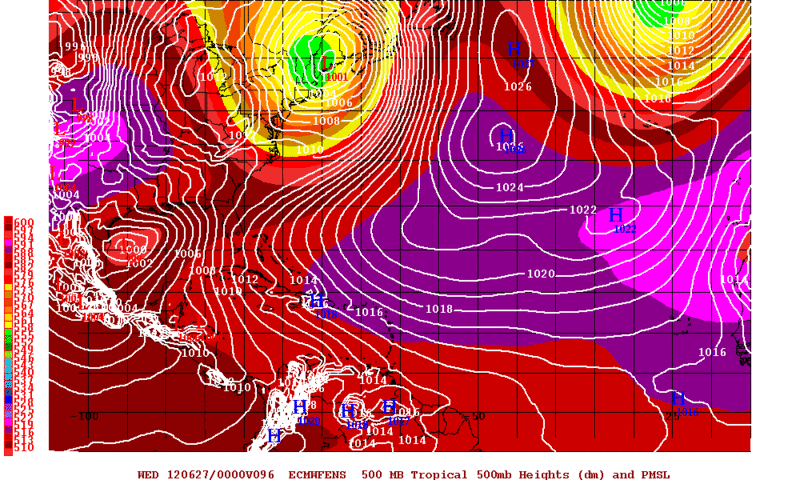
A ship an hour ago came within 75 miles (ESE) of the predicted center and reported the lowest pressure I've seen with this storm (1002.1 mb) and a sustained wind from the south at 28 knots.
0 likes
-
Dean4Storms
- S2K Supporter
- Posts: 6358
- Age: 63
- Joined: Sun Aug 31, 2003 1:01 pm
- Location: Miramar Bch. FL

Re: ATL: INVEST 96L - Discussion
Based on the latest Hi-res vis, surface reports, and the fact that organization is underway I fully anticipate TS debbie either on the 5pm advisory or a special advisory once recon confirms....Could make a run at Cat 1. Regardless flooding is going to be a big issue along the cental Gulf coast/FL....
0 likes
-
Hurricane Andrew

- S2K Supporter
- Posts: 1891
- Age: 27
- Joined: Sun May 23, 2010 2:53 pm
- Location: KS
0z ECMWF ensembles agree with the op.
http://raleighwx.americanwx.com/models/ ... SLP096.gif
3z SREF is split, showing two lows.
http://raleighwx.americanwx.com/models/ ... TUS087.gif
http://raleighwx.americanwx.com/models/ ... SLP096.gif
3z SREF is split, showing two lows.
http://raleighwx.americanwx.com/models/ ... TUS087.gif
0 likes
The Enthusiast
NREMT-AEMT, WX nerd
Irene '11, Sandy '12, Irma '17 (SAR)
"Hard to think we were born to live this way..." -Wage War
-
lrak

- S2K Supporter
- Posts: 1770
- Age: 59
- Joined: Thu Jun 21, 2007 2:48 pm
- Location: Corpus Christi, TX
Re: ATL: INVEST 96L - Discussion
Portastorm wrote:lrak wrote:Is there an ULL forming over SE TX? Will that help to stear it towards Florida? And do you guys see any swells likely for the TX coast? It seems to far North for a TX hit. I've never seen a storm that far North come back and hit TX. Been here 35 years
Thanks
Irak, the ULL is south of Sabine Pass and slowly sinking south. Right now it is providing enough shear to displace a lot of the convection to the east of the "center." It is progged to continue moving south into the Bay of Campeche and may ultimately help ventilate this system in a few days, IF, 96L moves into the WGOM. Air Force Met had a great post yesterday explaining all of this.
Thanks Portastorm, I'll look for that discussion.
0 likes
AKA karl
Also
Personal Forecast Disclaimer:
My posts on this forum are NOT official forecast and should not be used as such. My posts are my basic observations and are definitely not backed by any "well some" meteorological knowledge. For official information, please refer to the NHC and NWS products.
Also
Personal Forecast Disclaimer:
My posts on this forum are NOT official forecast and should not be used as such. My posts are my basic observations and are definitely not backed by any "well some" meteorological knowledge. For official information, please refer to the NHC and NWS products.
-
StormingB81

- S2K Supporter
- Posts: 5676
- Age: 44
- Joined: Thu Aug 27, 2009 1:45 am
- Location: Rockledge, Florida
I know if this comes to florida the winds wont be the main worry.....all over Florida we have had so much rain here it could flood very quickly
Personal Forecast Disclaimer:
The posts in this forum are NOT official forecast and should not be used as such. They are just the opinion of the poster and may or may not be backed by sound meteorological data. They are NOT endorsed by any professional institution or storm2k.org. For official information, please refer to the NHC and NWS products.
0 likes
-
Ivanhater

- Storm2k Moderator
- Posts: 11221
- Age: 39
- Joined: Fri Jul 01, 2005 8:25 am
- Location: Pensacola
Re: ATL: INVEST 96L - Discussion
Just looking at the Euro, it would seem it spins up pretty fast tonight. As AFM has stated, shear will still be an issue so well see if the Euro is correct in spinning this up by tonight.
0 likes
Michael
-
northjaxpro
- S2K Supporter
- Posts: 8900
- Joined: Mon Sep 27, 2010 11:21 am
- Location: Jacksonville, FL
Re: ATL: INVEST 96L - Discussion
Vortex wrote:Based on the latest Hi-res vis, surface reports, and the fact that organization is underway I fully anticipate TS debbie either on the 5pm advisory or a special advisory once recon confirms....Could make a run at Cat 1. Regardless flooding is going to be a big issue along the cental Gulf coast/FL....
Yeah, a Carnival Cruise liner in the vicinity of where the broad Low pressure center is approximately located reported having barometric pressure of 1002 mb.
I think when Recon gets in there, we will likely see this system designated straight to TS Debby this afternoon. NHC had already hinted in their TWO at 8 a.m. that they may initiate TS watches/warningsalong portions of the Northern Gulf coast, and it definitely looks like that will happen later today.
The posts in this forum are NOT official forecast and should not be used as such. They are just the opinion of the poster and may or may not be backed by sound meteorological data. They are NOT endorsed by any professional institution or storm2k.org. For official information, please refer to the NHC and NWS products.
0 likes
NEVER, EVER SAY NEVER in the tropics and weather in general, and most importantly, with life itself!!
________________________________________________________________________________________
Fay 2008 Beryl 2012 Debby 2012 Colin 2016 Hermine 2016 Julia 2016 Matthew 2016 Irma 2017 Dorian 2019
________________________________________________________________________________________
Fay 2008 Beryl 2012 Debby 2012 Colin 2016 Hermine 2016 Julia 2016 Matthew 2016 Irma 2017 Dorian 2019
-
Hurricane Andrew
- S2K Supporter
- Posts: 1891
- Age: 27
- Joined: Sun May 23, 2010 2:53 pm
- Location: KS
CIMSS Shear Tendency
http://tropic.ssec.wisc.edu/real-time/w ... oom=&time=
http://tropic.ssec.wisc.edu/real-time/w ... oom=&time=
0 likes
The Enthusiast
NREMT-AEMT, WX nerd
Irene '11, Sandy '12, Irma '17 (SAR)
"Hard to think we were born to live this way..." -Wage War
Re: ATL: INVEST 96L - Discussion
robbielyn wrote:bella_may wrote:30 to 40 MPH winds now being reported along the west coast of Florida. This thing is really intensifying.
Must be south of Tampa cuz its quiet here unless u talking marine winds
That's what the WC Guy must of been talking about. Still though that's a big increase from yesterday!
0 likes
-
Rgv20

- S2K Supporter
- Posts: 2466
- Age: 39
- Joined: Wed Jan 05, 2011 5:42 pm
- Location: Edinburg/McAllen Tx
The 0z Operational ECMWF has the majority of the Ensembles supporting the idea of a South Texas landfall.
0zECMWF Ensemble Means forecast valid for Tuesday Evening.
0zCMC Ensembles still agree on a more westward track to Texas rather than LA like the operational run showed.
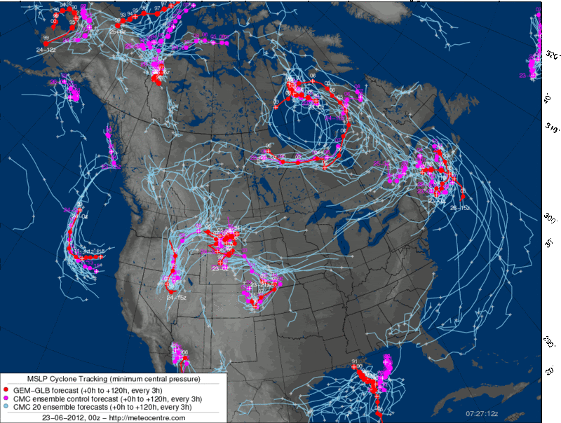
0zECMWF Ensemble Means forecast valid for Tuesday Evening.
0zCMC Ensembles still agree on a more westward track to Texas rather than LA like the operational run showed.
0 likes
The following post is NOT an official forecast and should not be used as such. It is just the opinion of the poster and may or may not be backed by sound meteorological data. It is NOT endorsed by any professional institution including storm2k.org For Official Information please refer to the NHC and NWS products.
-
cycloneye

- Admin

- Posts: 149309
- Age: 69
- Joined: Thu Oct 10, 2002 10:54 am
- Location: San Juan, Puerto Rico
Re: ATL: INVEST 96L - Discussion
This is from Bryan Norcross Facebook page:
Still on track and still just as confused a forecast for the Gulf system this morning. Winds in the Gulf have been measured right at tropical-storm strength, so the NHC might skip the Tropical Depression stage and go right to Tropical Storm Debby when it gets sufficiently organized. Right now, the upper winds are just unfavorable enough to limit organization (and they are pushing the rain toward... Florida). They are expected, however, to become somewhat more favorable, though not perfect, giving the system a chance to fully consolidate around the center. The first area of concern will be the northern Gulf. Flooding high tides, high waves, and dangerous beach conditions are expected. Watch for local warnings. The storm is expected to stay in the northern Gulf until Monday, then move either toward Florida or toward Texas/Mexico. When the NHC puts out its first track forecast, it will be interesting to see which scenario they choose. There is logic to each of them... though the historically best-performing model is the one aiming toward TX/MS. Stay tuned.
Still on track and still just as confused a forecast for the Gulf system this morning. Winds in the Gulf have been measured right at tropical-storm strength, so the NHC might skip the Tropical Depression stage and go right to Tropical Storm Debby when it gets sufficiently organized. Right now, the upper winds are just unfavorable enough to limit organization (and they are pushing the rain toward... Florida). They are expected, however, to become somewhat more favorable, though not perfect, giving the system a chance to fully consolidate around the center. The first area of concern will be the northern Gulf. Flooding high tides, high waves, and dangerous beach conditions are expected. Watch for local warnings. The storm is expected to stay in the northern Gulf until Monday, then move either toward Florida or toward Texas/Mexico. When the NHC puts out its first track forecast, it will be interesting to see which scenario they choose. There is logic to each of them... though the historically best-performing model is the one aiming toward TX/MS. Stay tuned.
0 likes
Visit the Caribbean-Central America Weather Thread where you can find at first post web cams,radars
and observations from Caribbean basin members Click Here
and observations from Caribbean basin members Click Here
Who is online
Users browsing this forum: No registered users and 21 guests