ATL: DEBBY - Post-Tropical
Moderator: S2k Moderators
-
cycloneye

- Admin

- Posts: 149315
- Age: 69
- Joined: Thu Oct 10, 2002 10:54 am
- Location: San Juan, Puerto Rico
Re: ATL: INVEST 96L - Recon Discussion
Plane flying at operational altitud.
0 likes
Visit the Caribbean-Central America Weather Thread where you can find at first post web cams,radars
and observations from Caribbean basin members Click Here
and observations from Caribbean basin members Click Here

Re: ATL: INVEST 96L - Discussion
Can someone snap a picture of the center right now and upload it ZOOMED IN? Visable Sat img.
Last edited by trave2 on Sat Jun 23, 2012 12:03 pm, edited 1 time in total.
0 likes
-
carpe vinum
- Tropical Wave

- Posts: 9
- Joined: Wed Jul 27, 2011 6:04 pm
- Location: College Station, TX
Re: ATL: INVEST 96L - Discussion
HH wheels up yet?
0 likes
Not a meteorologist, didn't even stay in a Holiday Inn Express last night.
Do not believe a word I say.
Do not believe a word I say.
-
Florida1118
Re: ATL: INVEST 96L - Discussion
carpe vinum wrote:HH wheels up yet?
Yes, they are currently en-route to 96L. Here is the thread
http://www.storm2k.org/phpbb2/viewtopic.php?f=59&t=112982&st=0&sk=t&sd=a&start=20
Last edited by Florida1118 on Sat Jun 23, 2012 11:55 am, edited 1 time in total.
0 likes
-
Rgv20

- S2K Supporter

- Posts: 2466
- Age: 39
- Joined: Wed Jan 05, 2011 5:42 pm
- Location: Edinburg/McAllen Tx
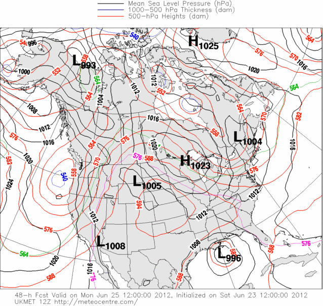
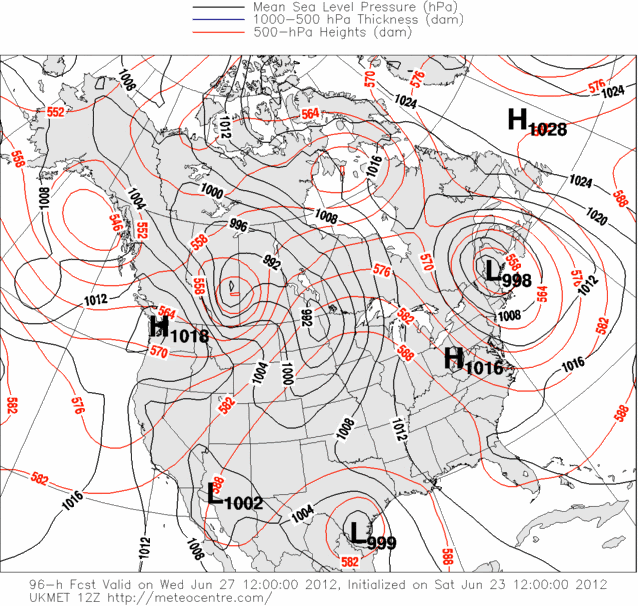
12zUKMET brings it really close to the LA coastline on Monday Morning then turns it WSW and makes landfall in the Lower Texas Coast by Wednesday Morning. With the forecast orientation of the ridge I can definitely see a WSW movement.
0 likes
The following post is NOT an official forecast and should not be used as such. It is just the opinion of the poster and may or may not be backed by sound meteorological data. It is NOT endorsed by any professional institution including storm2k.org For Official Information please refer to the NHC and NWS products.
-
tropicwatch

- Category 5

- Posts: 3426
- Age: 62
- Joined: Sat Jun 02, 2007 10:01 am
- Location: Panama City Florida
- Contact:
Re: ATL: INVEST 96L - Discussion
[quote="trave2"]Can someone snap a picture of the center right now and upload it? Visable Sat img.[/quote

Uploaded with ImageShack.us

Uploaded with ImageShack.us
0 likes
Tropicwatch
Agnes 72', Eloise 75, Elena 85', Kate 85', Charley 86', Florence 88', Beryl 94', Dean 95', Erin 95', Opal 95', Earl 98', Georges 98', Ivan 2004', Arlene 2005', Dennis 2005', Ida 2009' Debby 2012' Irma 2017' Michael 2018'
Agnes 72', Eloise 75, Elena 85', Kate 85', Charley 86', Florence 88', Beryl 94', Dean 95', Erin 95', Opal 95', Earl 98', Georges 98', Ivan 2004', Arlene 2005', Dennis 2005', Ida 2009' Debby 2012' Irma 2017' Michael 2018'


-
Dave

- Retired Staff

- Posts: 13442
- Age: 75
- Joined: Tue Aug 01, 2006 3:57 pm
- Location: Milan Indiana
- Contact:
000
URNT15 KNHC 231656
AF302 01AAA INVEST HDOB 08 20120623
164900 2656N 08845W 9664 00361 0069 +230 +229 058024 025 024 000 00
164930 2655N 08843W 9660 00362 0068 +230 +230 055023 024 024 001 01
165000 2654N 08842W 9663 00360 0067 +233 +229 058024 025 025 000 00
165030 2653N 08841W 9666 00356 0066 +235 +226 056024 026 026 000 00
165100 2652N 08840W 9667 00355 0066 +235 +222 058025 025 026 001 00
165130 2651N 08839W 9663 00357 0065 +235 +224 054024 025 025 001 00
165200 2650N 08837W 9667 00352 0064 +235 +228 051024 025 025 000 00
165230 2648N 08836W 9664 00355 0063 +235 +226 050024 024 025 001 00
165300 2647N 08835W 9659 00359 0063 +233 +230 051023 025 026 002 00
165330 2646N 08834W 9666 00353 0062 +235 +223 061026 027 025 004 00
165400 2645N 08833W 9667 00351 0061 +235 +221 061030 030 025 001 00
165430 2644N 08831W 9664 00352 0060 +233 +223 060031 032 026 000 00
165500 2643N 08830W 9664 00352 0060 +233 +224 060029 030 024 001 00
165530 2642N 08829W 9664 00351 0058 +233 +227 057027 029 026 001 00
165600 2641N 08828W 9665 00350 0058 +233 +226 055028 029 027 000 00
165630 2640N 08827W 9662 00352 0057 +233 +227 057030 032 028 000 00
165700 2639N 08825W 9662 00351 0056 +230 +230 054028 031 029 001 01
165730 2638N 08824W 9667 00346 0055 +231 +227 057030 032 027 000 00
165800 2637N 08823W 9664 00347 0055 +231 +224 059030 031 027 001 00
165830 2636N 08822W 9665 00347 0054 +231 +223 058030 032 027 001 00
$$
;
0 likes
This post is NOT AN OFFICIAL FORECAST and should not be used as such. It is just the opinion of the poster and may or may not be backed by sound meteorological data. It is NOT endorsed by any professional institution including storm2k.org. For Official Information please refer to the NHC and NWS products.
-
Hurricane Andrew

- S2K Supporter
- Posts: 1891
- Age: 27
- Joined: Sun May 23, 2010 2:53 pm
- Location: KS


Re: ATL: INVEST 96L - Discussion
trave2 wrote:Can someone snap a picture of the center right now and upload it? Visable Sat img.

0 likes
-
wxman57

- Moderator-Pro Met

- Posts: 23172
- Age: 68
- Joined: Sat Jun 21, 2003 8:06 pm
- Location: Houston, TX (southwest)
Re: ATL: INVEST 96L - Discussion
artist wrote:http://desmond.imageshack.us/Himg822/scaled.php?server=822&filename=96lj.jpg&res=landing
It's clear those two small vortices rotating around one another (and moving south) are not the center. The center appears to be about 40-50 miles east, near 26N/87W. Doesn't show up well on satellite, though.
0 likes


Re: ATL: INVEST 96L - Discussion
Yes - I agree about second Low developing to the West S. West of NHC plot (with High Cloud Tops over it)
Seems to be jogging N.E. Energy impulses from Yucatan area may be aiding in its new development.
Everything in Gulf comes in two's - it seems. They have been fighting each other -and agreed to seperate?
The very S.E. area of Gulf has least sheer - and upper High building nicely.
Disclaimer: I know less than nothing
http://www.ssec.wisc.edu/data/geo/index ... thod=flash
0 likes
Re: ATL: INVEST 96L - Discussion
crimi481 wrote:Yes - I agree about second Low developing to the West S. West of NHC plot (with High Cloud Tops over it)
Seems to be jogging N.E. Energy impulses from Yucatan area may be aiding in its new development.
Everything in Gulf comes in two's - it seems. They have been fighting each other -and agreed to seperate?
The very S.E. area of Gulf has least sheer - and upper High building nicely.
Disclaimer: I know less than nothing
http://www.ssec.wisc.edu/data/geo/index ... thod=flash
Sorry - I meant to the E.S.E of NHC Plot
0 likes
-
Hurricane Andrew
- S2K Supporter
- Posts: 1891
- Age: 27
- Joined: Sun May 23, 2010 2:53 pm
- Location: KS
Re: ATL: INVEST 96L - Discussion
wxman57 wrote:artist wrote:http://desmond.imageshack.us/Himg822/scaled.php?server=822&filename=96lj.jpg&res=landing
It's clear those two small vortices rotating around one another (and moving south) are not the center. The center appears to be about 40-50 miles east, near 26N/87W. Doesn't show up well on satellite, though.
What are your thougts on 96L?
0 likes
The Enthusiast
NREMT-AEMT, WX nerd
Irene '11, Sandy '12, Irma '17 (SAR)
"Hard to think we were born to live this way..." -Wage War
-
carpe vinum
- Tropical Wave
- Posts: 9
- Joined: Wed Jul 27, 2011 6:04 pm
- Location: College Station, TX
Re: ATL: INVEST 96L - Discussion
Thanks!
[off topic]Keesler, huh? Grew up there, cool.[/off topic]
[off topic]Keesler, huh? Grew up there, cool.[/off topic]
Florida1118 wrote:carpe vinum wrote:HH wheels up yet?
Yes, they are currently en-route to 96L. Here is the thread
http://www.storm2k.org/phpbb2/viewtopic.php?f=59&t=112982&st=0&sk=t&sd=a&start=20
0 likes
Not a meteorologist, didn't even stay in a Holiday Inn Express last night.
Do not believe a word I say.
Do not believe a word I say.
-
cycloneye
- Admin
- Posts: 149315
- Age: 69
- Joined: Thu Oct 10, 2002 10:54 am
- Location: San Juan, Puerto Rico
Re: ATL: INVEST 96L - Models
Ivanhater wrote:Canadian looks like around mobile at 96 hours
How strong it is?
0 likes
Visit the Caribbean-Central America Weather Thread where you can find at first post web cams,radars
and observations from Caribbean basin members Click Here
and observations from Caribbean basin members Click Here
-
caneman
Re: ATL: INVEST 96L - Models
Ivanhater wrote:Canadian looks like around mobile at 96 hours
If it makes landfall on No. Gulf the WSW motion may not matter a lot as their may not be much left and/or much time to strengthen. Hopefully just some beneficial rainfall for folks.
0 likes
Re: ATL: INVEST 96L - Discussion
wxman57 wrote:artist wrote:http://desmond.imageshack.us/Himg822/scaled.php?server=822&filename=96lj.jpg&res=landing
It's clear those two small vortices rotating around one another (and moving south) are not the center. The center appears to be about 40-50 miles east, near 26N/87W. Doesn't show up well on satellite, though.
I'm gonna have to disagree with you, the "CENTER" Is so wide right now that those two vorts are included in the center
0 likes

Who is online
Users browsing this forum: No registered users and 29 guests