ATL: DEBBY - Post-Tropical
Moderator: S2k Moderators
-
SouthFloridawx

- S2K Supporter

- Posts: 8346
- Age: 47
- Joined: Tue Jul 26, 2005 1:16 am
- Location: Sarasota, FL
- Contact:
ATL: DEBBY - Models
There's not much of a Center to Track anymore. Maybe a new low will form out of the convection over and to the East of Florida?
0 likes
-
SouthFloridawx
- S2K Supporter
- Posts: 8346
- Age: 47
- Joined: Tue Jul 26, 2005 1:16 am
- Location: Sarasota, FL
- Contact:


I would think it highly unlikely but if it got far enough south which would put it closer to the center of the anticyclone in a lower shear environment, would conditions be more favorable for it to restrengthen, per-say it re emerges south of Tampa?
0 likes
I am just an amateur and a "noob" at that so any speculations that I have made are just that, uneducated speculations. Please refer to the NHC for accurate information.
Thank you all for your thoughts, I've loved reading through this community since '06 and finally decided to post more actively.
-JJ
Thank you all for your thoughts, I've loved reading through this community since '06 and finally decided to post more actively.
-JJ
-
Hurricaneman

- Category 5

- Posts: 7404
- Age: 45
- Joined: Tue Aug 31, 2004 3:24 pm
- Location: central florida
Re: ATL: DEBBY - Tropical Depression - Discussion
I think this is about dead, and because of the major flooding this will be retired
The posts in this forum are NOT official forecast and should not be used as such. They are just the opinion of the poster and may or may not be backed by sound meteorological data. They are NOT endorsed by any professional institution or storm2k.org. For official information, please refer to the NHC and NWS products
The posts in this forum are NOT official forecast and should not be used as such. They are just the opinion of the poster and may or may not be backed by sound meteorological data. They are NOT endorsed by any professional institution or storm2k.org. For official information, please refer to the NHC and NWS products
0 likes


Re: ATL: DEBBY - Tropical Depression - Discussion
Amazing enough its still raining really good here. Some of the gustier winds we have had. Last blast before the end hopefully.
1:50 update Finally the end! North Florida is a mess but it could have been so much worse!
1:50 update Finally the end! North Florida is a mess but it could have been so much worse!
0 likes
The following post is NOT an official forecast and should not be used as such. It is just the opinion of the poster and may or may not be backed by sound meteorological data. It is NOT endorsed by any professional institution including storm2k.org For Official Information please refer to the NHC and NWS products.

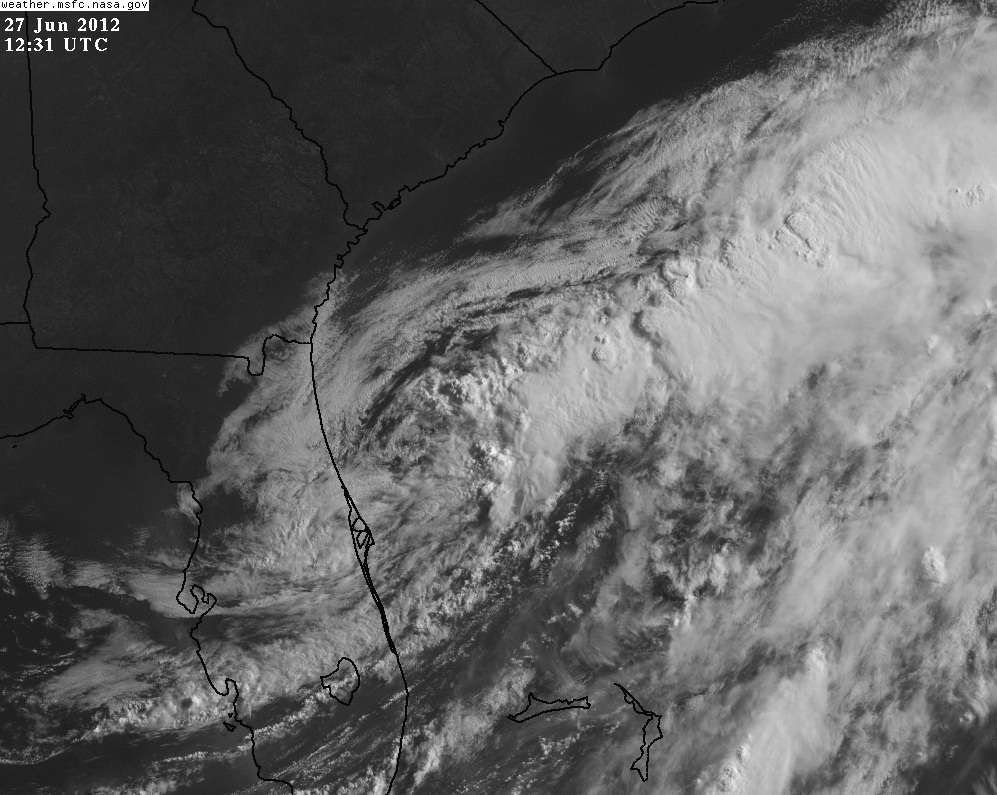
to me, based on satellite and the radar loop above, the center almost seems to be reforming west of Daytona
0 likes
The above post is not official and should not be used as such. It is the opinion of the poster and may or may not be backed by sound meteorological data. It is not endorsed by any professional institution or storm2k.org. For official information, please refer to the NHC and NWS products.
I was seeing the same thing with the "seem like" center west of daytona. If I have the right map here which I believe I do (correct me if I'm wrong) but it seems to support the idea.

Uploaded with ImageShack.us
Personal Forecast Disclaimer:
The posts in this forum are NOT official forecast and should not be used as such. They are just the opinion of the poster and may or may not be backed by sound meteorological data. They are NOT endorsed by any professional institution or storm2k.org. For official information, please refer to the NHC and NWS products.
0 likes
I am just an amateur and a "noob" at that so any speculations that I have made are just that, uneducated speculations. Please refer to the NHC for accurate information.
Thank you all for your thoughts, I've loved reading through this community since '06 and finally decided to post more actively.
-JJ
Thank you all for your thoughts, I've loved reading through this community since '06 and finally decided to post more actively.
-JJ
-
Jevo

- S2K Supporter
- Posts: 1729
- Age: 47
- Joined: Tue Aug 03, 2004 8:45 pm
- Location: The Flemish Cap
- Contact:
Re: ATL: DEBBY - Tropical Depression - Discussion
Goood morning Debby.... Those are some nice towers you're firing up this morning

0 likes
Disclaimer: 50% of the time I have no clue of what I am talking about. Chances are I am taking a less than educated guess that sounds good because 10 years ago I stole Mike Watkins book 'The Hurricane and its Impact'. For official information please direct yourself to the NHC and their cadre of weather geniuses.
-
plasticup
-
northjaxpro

- S2K Supporter
- Posts: 8900
- Joined: Mon Sep 27, 2010 11:21 am
- Location: Jacksonville, FL
Good morning everyone. It looks as if TD Debby has emerged off the Daytona Beach and heading out. But, she has left pleny of nastiness in her immediate wake across all of the peninsula. We have roads washed out with even sinkholes developing in some areas of the city, but the good news is that flood waters have receded where we don't have nearly as many roads closed off like what occured last night during the height of the flash flooding event. The rain has finally come to an end and the dry air is coming in on nice cool north to northeast winds around 20 -25 mph in some gusts across the area.
At my location in northern Jax, I have tallied an estimated 16.75 inches of rainfall since Sunday for this event with Debby. This surpasses the total I measured during TS Fay in 2008, which was a little over 14 inches. In general, totals range from 13 to as much as 17 inches across the Jax area for Debby's event.
Across areas just west of Jacksonville , especially Lake City and Live Oak, reported amounts in excess of 20 inches just within the past 24-36 hours. Those cities are completely under water currently. Also, many parts of Interstate 10 remains closed this morning from Lake City to Jacksonville.
The Saint Mary's River and Suwanee River are now forecast to break records sometime next week as they will go well above their previous record flood levels. Many people living along those river basins may lose their homes. The Black Creek in Middleburg in Clay County just south of Jax area is expected to break their flood stage record of 25.1 feet.
Since May 27, I have measured a total of more than 36 inches of rainfall, mainly courtesy of two tropical storms impacting the Jax area and a stationary frontal boundary which sat over our region earlier this month. This has made the drought that we were experiencing just a month ago seem like a disstant memory now.
2012 has already been a very historic season for this region, with Beryl and Debby impacting Jax area and Northeast FL within 30 days. Mother Nature we have received the message. You have ended the drought for sure in this area. But, please we don't need any more tropical cyclones in this area. We have had enough thank you!
0 likes
NEVER, EVER SAY NEVER in the tropics and weather in general, and most importantly, with life itself!!
________________________________________________________________________________________
Fay 2008 Beryl 2012 Debby 2012 Colin 2016 Hermine 2016 Julia 2016 Matthew 2016 Irma 2017 Dorian 2019
________________________________________________________________________________________
Fay 2008 Beryl 2012 Debby 2012 Colin 2016 Hermine 2016 Julia 2016 Matthew 2016 Irma 2017 Dorian 2019
Re: ATL: DEBBY - Tropical Depression - Discussion
Now that Debby is nearly done with for the U.S., I'm surprised that no one has begun talking about the tropical wave in the Eastern Atlantic yet.
0 likes
"People might not get all they work for in this world, but they must certainly work for all they get."- Frederick Douglass

-
cycloneye

- Admin

- Posts: 149275
- Age: 69
- Joined: Thu Oct 10, 2002 10:54 am
- Location: San Juan, Puerto Rico
Re: ATL: DEBBY - Tropical Depression - Discussion
AHS2011 wrote:Now that Debby is nearly done with for the U.S., I'm surprised that no one has begun talking about the tropical wave in the Eastern Atlantic yet.
We are talking about that area at Talking Tropics forum in this thread.
viewtopic.php?f=31&t=113053&hilit=&p=2237302#p2237302
0 likes
Visit the Caribbean-Central America Weather Thread where you can find at first post web cams,radars
and observations from Caribbean basin members Click Here
and observations from Caribbean basin members Click Here

FLOOD WARNING
NATIONAL WEATHER SERVICE JACKSONVILLE FL
722 AM EDT WED JUN 27 2012
...FORECAST FLOODING CHANGED FROM MAJOR TO RECORD SEVERITY FOR THE
FOLLOWING RIVERS IN FLORIDA...GEORGIA...
ST MARY`S RIVER AT MACCLENNY AFFECTING BAKER...NASSAU...CAMDEN AND
CHARLTON COUNTIES
...RECORD FLOODING IS OCCURRING AND EXPECTED TO CONTINUE
0 likes
Re: ATL: DEBBY - Tropical Depression - Discussion
cycloneye wrote:AHS2011 wrote:Now that Debby is nearly done with for the U.S., I'm surprised that no one has begun talking about the tropical wave in the Eastern Atlantic yet.
We are talking about that area at Talking Tropics forum in this thread.
viewtopic.php?f=31&t=113053&hilit=&p=2237302#p2237302
Thank you.
0 likes
"People might not get all they work for in this world, but they must certainly work for all they get."- Frederick Douglass
-
tolakram
- Admin
- Posts: 20179
- Age: 62
- Joined: Sun Aug 27, 2006 8:23 pm
- Location: Florence, KY (name is Mark)
Re: ATL: DEBBY - Tropical Depression - Discussion
Latest
Loops
http://wwwghcc.msfc.nasa.gov/cgi-bin/ge ... umframes=5
http://www.esl.lsu.edu/animate/goes/ind ... channel=ir
Loops
http://wwwghcc.msfc.nasa.gov/cgi-bin/ge ... umframes=5
http://www.esl.lsu.edu/animate/goes/ind ... channel=ir
0 likes
M a r k
- - - - -
Join us in chat: Storm2K Chatroom Invite. Android and IOS apps also available.
The posts in this forum are NOT official forecasts and should not be used as such. Posts are NOT endorsed by any professional institution or STORM2K.org. For official information and forecasts, please refer to NHC and NWS products.
-
wxman57

- Moderator-Pro Met

- Posts: 23172
- Age: 68
- Joined: Sat Jun 21, 2003 8:06 pm
- Location: Houston, TX (southwest)
Re: ATL: DEBBY - Tropical Depression - Discussion
Debby's best days are way behind it. It's merged with the cold front and is ingesting plenty of dry air as it accelerates up the front into higher and higher shear. NHC will probably issue the final advisory this morning or they may wait until this afternoon. Bones says it's time to call this one. And he says he's looking forward to a nice quiet 4th of July week.

0 likes
-
Jevo
- S2K Supporter
- Posts: 1729
- Age: 47
- Joined: Tue Aug 03, 2004 8:45 pm
- Location: The Flemish Cap
- Contact:
Re: ATL: DEBBY - Tropical Depression - Discussion
wxman57 wrote:Debby's best days are way behind it. It's merged with the cold front and is ingesting plenty of dry air as it accelerates up the front into higher and higher shear. NHC will probably issue the final advisory this morning or they may wait until this afternoon. Bones says it's time to call this one. And he says he's looking forward to a nice quiet[ 4th of July week.
http://home.comcast.net/~cgh57/itsdeadjim.jpg
This made my day... well done sir
0 likes
Disclaimer: 50% of the time I have no clue of what I am talking about. Chances are I am taking a less than educated guess that sounds good because 10 years ago I stole Mike Watkins book 'The Hurricane and its Impact'. For official information please direct yourself to the NHC and their cadre of weather geniuses.
-
ozonepete
- Professional-Met

- Posts: 4743
- Joined: Mon Sep 07, 2009 3:23 pm
- Location: From Ozone Park, NYC / Now in Brooklyn, NY
Re: ATL: DEBBY - Tropical Depression - Discussion
wxman57 wrote:Debby's best days are way behind it. It's merged with the cold front and is ingesting plenty of dry air as it accelerates up the front into higher and higher shear. NHC will probably issue the final advisory this morning or they may wait until this afternoon. Bones says it's time to call this one. And he says he's looking forward to a nice [b]quiet[/b] 4th of July week.
Always nice to see Bones but he may be replaced by Lazarus soon. I agree its got a tough road ahead to re-strengthen, but for clarification, the latest HPC surface analysis and their forecast charts show Debby is not merged with the front (it's a stationary front now) and isn't forecast to merge with it either.
Here's the HPC?NCEP loop (for those who don't know, all TC positions are done in cooperation with the NHC):
http://www.hpc.ncep.noaa.gov/basicwx/day0-7loop.html
0 likes
Who is online
Users browsing this forum: No registered users and 26 guests