I hope El Nino brings an early end to this hurricane season which has already been bad for Florida with the
tornadoes and flooding from 2 tropical cyclones.
ATL: DEBBY - Post-Tropical
Moderator: S2k Moderators
-
Tampa Bay Hurricane

- Category 5

- Posts: 5597
- Age: 38
- Joined: Fri Jul 22, 2005 7:54 pm
- Location: St. Petersburg, FL
Re: ATL: DEBBY - Post-Tropical
Always watch anything that still has spin and crosses over the Gulf Stream. 
0 likes
-
northjaxpro

- S2K Supporter

- Posts: 8900
- Joined: Mon Sep 27, 2010 11:21 am
- Location: Jacksonville, FL
Re:
Tampa Bay Hurricane wrote:I hope El Nino brings an early end to this hurricane season which has already been bad for Florida with the
tornadoes and flooding from 2 tropical cyclones.
From someone here who is extremely weary of all of the tropical activity in this part of the world this past month, I 100% say AMEN to this!!!
0 likes
NEVER, EVER SAY NEVER in the tropics and weather in general, and most importantly, with life itself!!
________________________________________________________________________________________
Fay 2008 Beryl 2012 Debby 2012 Colin 2016 Hermine 2016 Julia 2016 Matthew 2016 Irma 2017 Dorian 2019
________________________________________________________________________________________
Fay 2008 Beryl 2012 Debby 2012 Colin 2016 Hermine 2016 Julia 2016 Matthew 2016 Irma 2017 Dorian 2019
-
brunota2003

- S2K Supporter
- Posts: 9476
- Age: 35
- Joined: Sat Jul 30, 2005 9:56 pm
- Location: Stanton, KY...formerly Havelock, NC
- Contact:
Re: ATL: DEBBY - Post-Tropical
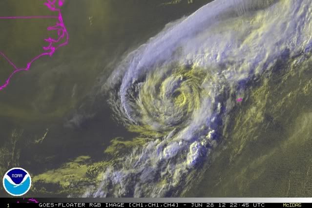
Looking at the latest with Ex-Debby...I think it has a good 50% or 60% chance of regeneration. Tight LLC, good fanning out of cirrus clouds (means low shear), the thunderstorms are no longer being blown away, and a band of convection is setting up on the SE side of the circulation and is starting to feed into her. Also of note, the circulation is heading east, but in the last couple hours it appeared to start dropping to the ESE and maybe slowing a little.
Current intensity seems to be 40 knots (1 minute sustained winds of 40 knots measured at Buoy 41048). Lowest pressure at that buoy was 999 millibars at 4:16 pm EDT, with winds of roughly 30 knots...so minimum pressure is likely around 996 or 997 millibars.
Current intensity seems to be 40 knots (1 minute sustained winds of 40 knots measured at Buoy 41048). Lowest pressure at that buoy was 999 millibars at 4:16 pm EDT, with winds of roughly 30 knots...so minimum pressure is likely around 996 or 997 millibars.
Personal Forecast Disclaimer:
The posts in this forum are NOT official forecast and should not be used as such. They are just the opinion of the poster and may or may not be backed by sound meteorological data. They are NOT endorsed by any professional institution or storm2k.org. For official information, please refer to the NHC and NWS products.
0 likes
Just a small town southern boy helping other humans.


Re: ATL: DEBBY - Post-Tropical
She's looking pretty durn intense for a typical extratropical cyclone.
0 likes
NOTICE: I cannot give an expert analysis. Most of my "observations" are made visually with the help of only vital information provided by public advisories.

-
brunota2003
- S2K Supporter
- Posts: 9476
- Age: 35
- Joined: Sat Jul 30, 2005 9:56 pm
- Location: Stanton, KY...formerly Havelock, NC
- Contact:
-
ozonepete
- Professional-Met

- Posts: 4743
- Joined: Mon Sep 07, 2009 3:23 pm
- Location: From Ozone Park, NYC / Now in Brooklyn, NY
Re:
brunota2003 wrote:There is...the analysis has a cold front to the south and warm front to the north at this time.
Here's the last statement from NHC:
TROPICAL WEATHER OUTLOOK
NWS NATIONAL HURRICANE CENTER MIAMI FL
200 PM EDT THU JUN 28 2012
FOR THE NORTH ATLANTIC...CARIBBEAN SEA AND THE GULF OF MEXICO...
1. A LOW PRESSURE AREA...THE POST-TROPICAL REMNANTS OF DEBBY...IS MOVING NORTHEASTWARD AT 20 TO 25 MPH ALONG OR JUST SOUTH OF A FRONTAL BOUNDARY ABOUT 300 MILES WEST OF BERMUDA. THE LOW IS PRODUCING SOME SHOWER AND THUNDERSTORM ACTIVITY AND WINDS TO GALE FORCE. THIS SYSTEM HAS A LOW CHANCE...10 PERCENT...OF BECOMING A TROPICAL CYCLONE AGAIN DURING THE NEXT 48 HOURS. ADDITIONAL INFORMATION ON THIS LOW CAN BE FOUND IN HIGH SEAS FORECASTS ISSUED BY THE NATIONAL WEATHER SERVICE.
It is so hard to tell without enough data in the vicinity that they said "along or just south of the boundary". What you can take away from this is that there is plenty of concern that it will become tropical again.
So yes, brunota, I agree with your 50-60% chance. Looks more and more tropical.
Last edited by ozonepete on Thu Jun 28, 2012 6:38 pm, edited 1 time in total.
0 likes
-
ozonepete
- Professional-Met
- Posts: 4743
- Joined: Mon Sep 07, 2009 3:23 pm
- Location: From Ozone Park, NYC / Now in Brooklyn, NY
Re: ATL: DEBBY - Post-Tropical
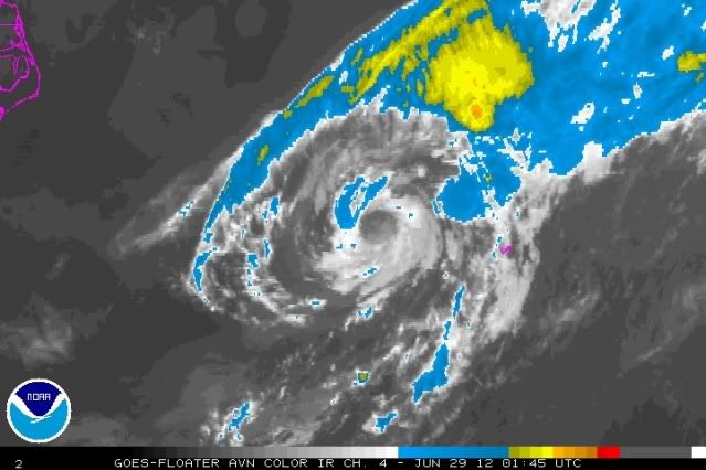
Do these satellite images remind you of Chris or what? And right now it's over warmer water than Chris was when it started strengthening into a hurricane.
0 likes
-
cycloneye

- Admin

- Posts: 149275
- Age: 69
- Joined: Thu Oct 10, 2002 10:54 am
- Location: San Juan, Puerto Rico
Re: ATL: DEBBY - Post-Tropical
8 PM EDT TWO:
A LOW PRESSURE AREA...THE POST-TROPICAL REMNANTS OF DEBBY...IS
LOCATED ABOUT 225 MILES WEST OF BERMUDA AND MOVING EAST-
NORTHEASTWARD AT 20 TO 25 MPH. THE LOW IS PRODUCING GALE-FORCE
WINDS NEAR THE CENTER. HOWEVER...THE ASSOCIATED SHOWER ACTIVITY IS
CURRENTLY MINIMAL...AND ABUNDANT DRY AIR NEAR THE LOW IS EXPECTED
TO PREVENT RE-DEVELOPMENT. THIS SYSTEM HAS A LOW CHANCE...10
PERCENT...OF BECOMING A TROPICAL CYCLONE AGAIN DURING THE NEXT
48 HOURS. ADDITIONAL INFORMATION ON THIS LOW CAN BE FOUND IN HIGH
SEAS FORECASTS ISSUED BY THE NATIONAL WEATHER SERVICE.
0 likes
Visit the Caribbean-Central America Weather Thread where you can find at first post web cams,radars
and observations from Caribbean basin members Click Here
and observations from Caribbean basin members Click Here
-
ozonepete
- Professional-Met
- Posts: 4743
- Joined: Mon Sep 07, 2009 3:23 pm
- Location: From Ozone Park, NYC / Now in Brooklyn, NY
Re: ATL: DEBBY - Post-Tropical
0 likes
-
cycloneye
- Admin
- Posts: 149275
- Age: 69
- Joined: Thu Oct 10, 2002 10:54 am
- Location: San Juan, Puerto Rico
Re: ATL: DEBBY - Post-Tropical
The 00z Best Track has the pressure down to 997 mbs.
AL, 04, 2012062900, , BEST, 0, 326N, 683W, 40, 997, LO
http://ftp.nhc.noaa.gov/atcf/tcweb/inve ... 012.invest
AL, 04, 2012062900, , BEST, 0, 326N, 683W, 40, 997, LO
http://ftp.nhc.noaa.gov/atcf/tcweb/inve ... 012.invest
0 likes
Visit the Caribbean-Central America Weather Thread where you can find at first post web cams,radars
and observations from Caribbean basin members Click Here
and observations from Caribbean basin members Click Here
-
ozonepete
- Professional-Met
- Posts: 4743
- Joined: Mon Sep 07, 2009 3:23 pm
- Location: From Ozone Park, NYC / Now in Brooklyn, NY
Re: ATL: DEBBY - Post-Tropical
0 likes
-
ozonepete
- Professional-Met
- Posts: 4743
- Joined: Mon Sep 07, 2009 3:23 pm
- Location: From Ozone Park, NYC / Now in Brooklyn, NY
Re: ATL: DEBBY - Post-Tropical
Hey Luis, do you know how ACE is counted for post-tropical systems? Not at all I would guess but I'm not sure.
0 likes
-
cycloneye
- Admin
- Posts: 149275
- Age: 69
- Joined: Thu Oct 10, 2002 10:54 am
- Location: San Juan, Puerto Rico
Re: ATL: DEBBY - Post-Tropical
ozonepete wrote:Hey Luis, do you know how ACE is counted for post-tropical systems? Not at all I would guess but I'm not sure.
Dont count.
0 likes
Visit the Caribbean-Central America Weather Thread where you can find at first post web cams,radars
and observations from Caribbean basin members Click Here
and observations from Caribbean basin members Click Here
-
wxman57

- Moderator-Pro Met

- Posts: 23172
- Age: 68
- Joined: Sat Jun 21, 2003 8:06 pm
- Location: Houston, TX (southwest)
Re: ATL: DEBBY - Post-Tropical
It lost all of its convection this evening and is still attached to the cold front. As the NHC indicates, not a great chance they're going to mess with it any more.
0 likes
-
ozonepete
- Professional-Met
- Posts: 4743
- Joined: Mon Sep 07, 2009 3:23 pm
- Location: From Ozone Park, NYC / Now in Brooklyn, NY
Re: ATL: DEBBY - Post-Tropical
0 likes
-
ozonepete
- Professional-Met
- Posts: 4743
- Joined: Mon Sep 07, 2009 3:23 pm
- Location: From Ozone Park, NYC / Now in Brooklyn, NY
Re: ATL: DEBBY - Post-Tropical
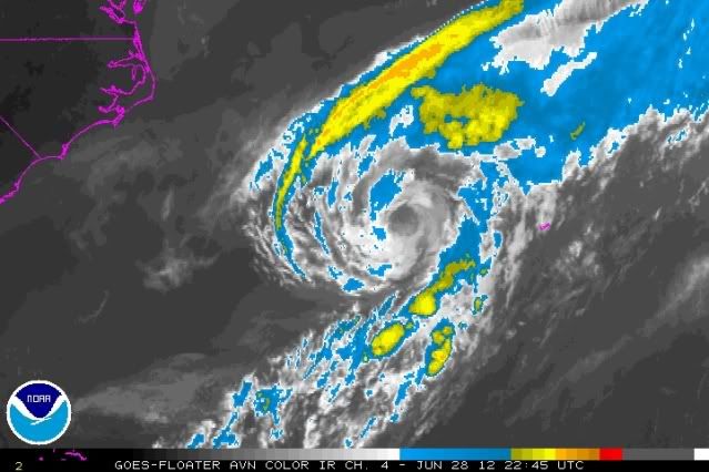
And there is one more factor I forgot to mention, which was a major factor in why Chris developed after everyone left it for dead and became a hurricane after everyone said the SSTs were too low: symmetry. Symmetry allows for very efficient transfer of energy in towards the center from the outer edges at the surface and then upward as it reaches the COC, and it can compensate for lower SSTs as we clearly saw for Chris. Right now Debby has a nearly perfectly circular eye, or COC, and that is a major reason it has not dissipated. I still would agree that the dry air situation is key and could kill it really easily, but it looks 50/50 because the storm itself is still sucking up a lot of warm moist air up from the ocean which serves to gradually moisten its own environment. Just fascinating to watch. I live for this stuff. lol.
Btw, if the center gets stretched again, it's all over.
Btw, if the center gets stretched again, it's all over.
0 likes
-
cycloneye
- Admin
- Posts: 149275
- Age: 69
- Joined: Thu Oct 10, 2002 10:54 am
- Location: San Juan, Puerto Rico
Re: ATL: DEBBY - Post-Tropical
8 AM TWO:
A LOW PRESSURE AREA...THE POST-TROPICAL REMNANTS OF DEBBY...IS
LOCATED ABOUT 90 MILES NORTH-NORTHWEST OF BERMUDA AND MOVING EAST-
NORTHEASTWARD AT 20 TO 25 MPH. ALTHOUGH THIS DISTURBANCE IS
PRODUCING GALE-FORCE WINDS NEAR THE CENTER...SHOWER ACTIVITY
REMAINS MINIMAL AND ENVIRONMENTAL CONDITIONS ARE EXPECTED TO REMAIN
UNFAVORABLE FOR RE-DEVELOPMENT TO OCCUR. THIS SYSTEM HAS A LOW
CHANCE...10 PERCENT...OF BECOMING A TROPICAL CYCLONE AGAIN DURING
THE NEXT 48 HOURS. ADDITIONAL INFORMATION ON THIS LOW CAN BE FOUND
IN HIGH SEAS FORECASTS ISSUED BY THE NATIONAL WEATHER SERVICE.
0 likes
Visit the Caribbean-Central America Weather Thread where you can find at first post web cams,radars
and observations from Caribbean basin members Click Here
and observations from Caribbean basin members Click Here
-
wxman57
- Moderator-Pro Met
- Posts: 23172
- Age: 68
- Joined: Sat Jun 21, 2003 8:06 pm
- Location: Houston, TX (southwest)
Re: ATL: DEBBY - Post-Tropical
Debby is quite tenacious, refusing to be beaten down by the cold front it's still attached to. Will our strongest storms this season all be north of 35N?
0 likes
Who is online
Users browsing this forum: No registered users and 27 guests