Texas Summer 2012

U.S. & Caribbean Weather Discussions and Severe Weather Events

Moderator: S2k Moderators

Forum rules

The posts in this forum are NOT official forecast and should not be used as such. They are just the opinion of the poster and may or may not be backed by sound meteorological data. They are NOT endorsed by any professional institution or STORM2K.

Help Support Storm2K
Message
Author
User avatar
somethingfunny
ChatStaff
ChatStaff
Posts: 3926
Age: 36
Joined: Thu May 31, 2007 10:30 pm
Location: McKinney, Texas

Re:

#241 Postby somethingfunny » Thu Jun 28, 2012 2:53 pm

Texas Snowman wrote:Looking at the news and photos coming out of Colorado Springs about the Waldo Canyon wildfire, it got me to thinking about the wildfires in Texas last summer.

Especially the Bastrop Complex wildfire. So I went to Wikipedia to check out the final numbers. They were and still are just staggering to me:

"1,691 homes were destroyed by the fire, making it the most destructive single wildfire in Texas history. After being largely contained in late September, the fire was finally declared controlled on October 10, and declared extinguished on October 29, having killed two people and inflicted an estimated $325 million of insured property damage."

http://en.wikipedia.org/wiki/Bastrop_Co ... mplex_fire


Nearly 1,700 homes destroyed by a single wildfire is staggering even by West Coast standards.

I'll never forget Tropical Storm Lee for that, the dry lee-side of Lee ( :lol: ) caused a complete catastrophe here over Labor Day Weekend.

Here in DFW, I'll always remember April 2011, when those powerful low pressure systems that brought all the tornadoes to the Southeast came through here dry, with 50mph winds whipping in smoke from the west. I've never seen anything like it, all the smoke and cement dust and fertilizer dust flying through the air at 50mph, the sun gray behind the haze, the campfire/chemical smell, and how the horrible air quality seemed to ignite a primitive instinct that put everybody I met on edge and in a bad mood. I hope we don't ever have something like that here again.
0 likes   
I am not a meteorologist, and any posts made by me are not official forecasts or to be interpreted as being intelligent. These posts are just my opinions and are probably silly opinions.

User avatar
horselattitudesfarm
Category 1
Category 1
Posts: 315
Joined: Thu Jul 16, 2009 5:55 pm
Location: Asheville, NC (formerly from Dallas, TX)

Re: Re:

#242 Postby horselattitudesfarm » Thu Jun 28, 2012 4:02 pm

Texas Snowman wrote:Here in DFW, I'll always remember April 2011, when those powerful low pressure systems that brought all the tornadoes to the Southeast came through here dry, with 50mph winds whipping in smoke from the west. I've never seen anything like it, all the smoke and cement dust and fertilizer dust flying through the air at 50mph, the sun gray behind the haze, the campfire/chemical smell, and how the horrible air quality seemed to ignite a primitive instinct that put everybody I met on edge and in a bad mood. I hope we don't ever have something like that here again.

Very well put Texas Snowman. I remember telling my wife how it smelled like the area around Mt. St. Helens a few years after it erupted when we were hiking there, all dusty and ashy.
0 likes   

User avatar
Texas Snowman
Storm2k Moderator
Storm2k Moderator
Posts: 6151
Joined: Fri Jan 25, 2008 11:29 am
Location: Denison, Texas

Re: Re:

#243 Postby Texas Snowman » Thu Jun 28, 2012 9:19 pm

somethingfunny wrote:Nearly 1,700 homes destroyed by a single wildfire is staggering even by West Coast standards.


In no way - again, in no way - am I trying to make light of what is going on in Colorado Springs right now where (according to their mayor) at least 346 homes have been destroyed by the Waldo Canyon fire.

That is awful, horrible, and so tragic.

But it also points out just how terrible things were here in Texas last summer.

In addition to the Bastrop Complex fire where the 1,600+ homes were destroyed, there were numerous other destructive wildfires that raged.

Again, from Wikipedia:

"From the beginning of the fire season to October 31, around 27,976 fires had burned 3,959,040 acres (about double the previous record), 2,862 homes (1,939 of which were destroyed over the Labor Day weekend), and over 2,700 other structures. 47.3% of all acreage burned in the United States in 2011 was burned in Texas."

http://en.wikipedia.org/wiki/2011_texas_wildfires
0 likes   
The above post and any post by Texas Snowman is NOT an official forecast and should not be used as such. It is just the opinion of the poster and may or may not be backed by sound meteorological data. It is NOT endorsed by any professional institution including storm2k.org. For official information, please refer to NWS products.

User avatar
Rgv20
S2K Supporter
S2K Supporter
Posts: 2466
Age: 38
Joined: Wed Jan 05, 2011 5:42 pm
Location: Edinburg/McAllen Tx

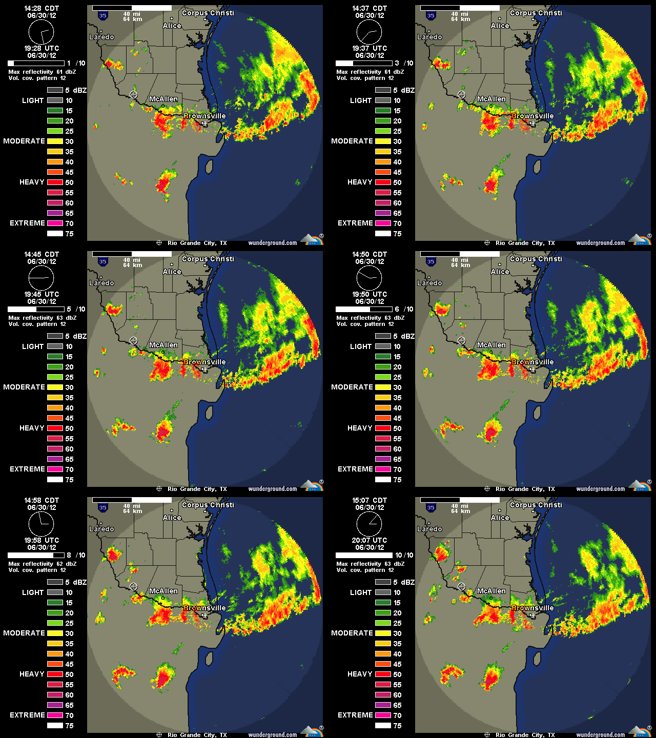
#244 Postby Rgv20 » Sat Jun 30, 2012 3:16 pm

The rain is so close! Hopefully I can in on some of the action later this afternoon :D

Image
0 likes   
The following post is NOT an official forecast and should not be used as such. It is just the opinion of the poster and may or may not be backed by sound meteorological data. It is NOT endorsed by any professional institution including storm2k.org For Official Information please refer to the NHC and NWS products.

User avatar
Ntxw
Storm2k Moderator
Storm2k Moderator
Posts: 22731
Joined: Wed Oct 21, 2009 6:34 pm
Location: DFW, Texas

Re: Texas Summer 2012

#245 Postby Ntxw » Sat Jun 30, 2012 3:22 pm

It's a little strange to see the rest of the country bake while Texas is near normal lol. Next time they make fun of us about driving in ice and snow they should think about this little heat wave they're in :P

Trough in the NW gulf sure is a pleasant surprise hoping you southern Texas folks get as much rain as possible! PNA is positive and looks to straddle neutral for awhile. We'll probably get hot again with chances of thunderstorms somewhere in the state but nothing extreme. Looking longer range if CPC declares El Nino within the next weeks I think August will be interesting for Texas as the pattern transition from neutral to nino will begin.
0 likes   
The above post and any post by Ntxw is NOT an official forecast and should not be used as such. It is just the opinion of the poster and may or may not be backed by sound meteorological data. It is NOT endorsed by any professional institution including Storm2k. For official information, please refer to NWS products.

  Help support Storm2K!
Help Support Storm2K

User avatar
Portastorm
Storm2k Moderator
Storm2k Moderator
Posts: 9914
Age: 62
Joined: Fri Jul 11, 2003 9:16 am
Location: Round Rock, TX
Contact:

Re: Texas Summer 2012

#246 Postby Portastorm » Sat Jun 30, 2012 4:50 pm

I know weatherdude1108 will share my misery ... once again, for the umpteenth time this year, I watched a beautiful blob of greens and yellows on the radar this afternoon move towards the Austin metropolitan area ... only to see it literally disappear before it moved over the Travis County line. This is freakin' ridiculous! :grrr:

I think for June we received less than a tenth of an inch of rainfall.
0 likes   
Any forecasts under my name are to be taken with a grain of salt. Get your best forecasts from the National Weather Service and National Hurricane Center.

User avatar
South Texas Storms
Professional-Met
Professional-Met
Posts: 4201
Joined: Thu Jun 24, 2010 12:28 am
Location: Houston, TX

Re: Texas Summer 2012

#247 Postby South Texas Storms » Sat Jun 30, 2012 5:26 pm

Portastorm wrote:I know weatherdude1108 will share my misery ... once again, for the umpteenth time this year, I watched a beautiful blob of greens and yellows on the radar this afternoon move towards the Austin metropolitan area ... only to see it literally disappear before it moved over the Travis County line. This is freakin' ridiculous! :grrr:

I think for June we received less than a tenth of an inch of rainfall.


Same thing happened to SA yesterday Porta. And I think less than .50 inch this month here as well. I'm so tired of it! When is it our turn? Hopefully tomorrow!
0 likes   

User avatar
vbhoutex
Storm2k Executive
Storm2k Executive
Posts: 29096
Age: 73
Joined: Wed Oct 09, 2002 11:31 pm
Location: Cypress, TX
Contact:

Re: Texas Summer 2012

#248 Postby vbhoutex » Sat Jun 30, 2012 7:16 pm

South Texas Storms wrote:
Portastorm wrote:I know weatherdude1108 will share my misery ... once again, for the umpteenth time this year, I watched a beautiful blob of greens and yellows on the radar this afternoon move towards the Austin metropolitan area ... only to see it literally disappear before it moved over the Travis County line. This is freakin' ridiculous! :grrr:

I think for June we received less than a tenth of an inch of rainfall.


Same thing happened to SA yesterday Porta. And I think less than .50 inch this month here as well. I'm so tired of it! When is it our turn? Hopefully tomorrow!

Since the ULL is moving W you may get some tomorrow. At my house in W. Houston we got 2.15" of rain today. We don't need anymore for a few days so maybe we can spare some. :cheesy:
0 likes   
Skywarn, C.E.R.T.
Please click below to donate to STORM2K to help with the expenses of keeping the site going:
Image

User avatar
Rgv20
S2K Supporter
S2K Supporter
Posts: 2466
Age: 38
Joined: Wed Jan 05, 2011 5:42 pm
Location: Edinburg/McAllen Tx

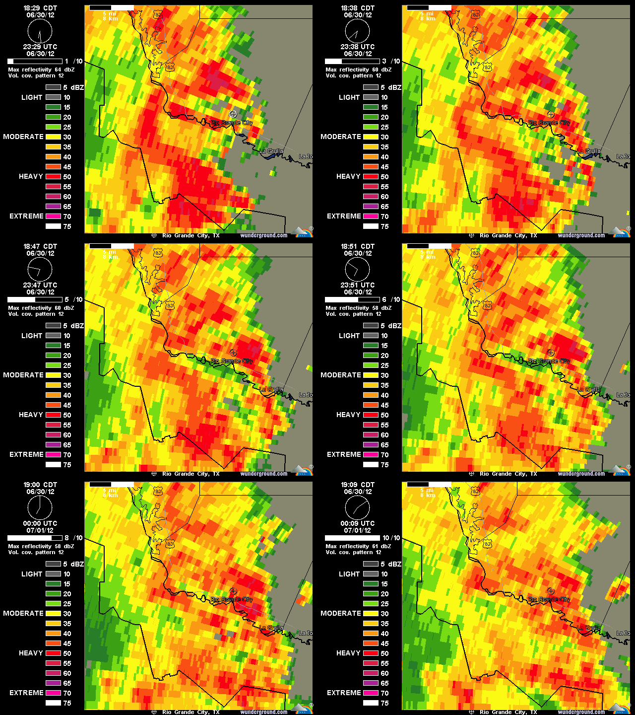
#249 Postby Rgv20 » Sat Jun 30, 2012 7:17 pm

It has been pouring at my house for about 30 minutes now....there is no sign of letting up :P

Flash Flood Warning

FLASH FLOOD WARNING
TXC427-505-010130-
/O.NEW.KBRO.FF.W.0012.120630T2326Z-120701T0130Z/
/00000.0.ER.000000T0000Z.000000T0000Z.000000T0000Z.OO/

BULLETIN - EAS ACTIVATION REQUESTED
FLASH FLOOD WARNING
NATIONAL WEATHER SERVICE BROWNSVILLE TX
626 PM CDT SAT JUN 30 2012

THE NATIONAL WEATHER SERVICE IN BROWNSVILLE HAS ISSUED A

* FLASH FLOOD WARNING FOR...
WESTERN STARR COUNTY IN DEEP SOUTH TEXAS...
THIS INCLUDES THE CITIES OF...LA ROSITA...ROMA...FALCON DAM...EL
SAUZ.
SOUTHEASTERN ZAPATA COUNTY IN DEEP SOUTH TEXAS...
THIS INCLUDES THE CITY OF FALCON.

* UNTIL 830 PM CDT

* AT 623 PM CDT...RADAR ESTIMATED THAT AS MUCH AS NINE INCHES OF
RAIN HAS FALLEN THIS AFTERNOON NEAR FALCON DAM.
FOUR TO FIVE INCHES
IS ESTIMATED TO HAVE FALLEN BETWEEN EL SAUZ AND ALEJANDRENAS ALONG
THE HIGHWAY 83 CORRIDOR. HEAVY RAIN CONTINUES AND ANOTHER TWO TO
THREE INCHES OF RAIN IS POSSIBLE.

THIS IS A PARTICULARLY DANGEROUS SITUATION FOR THOSE NEAR FALCON
DAM...FALCON STATE PARK...FALCON HEIGHTS...AND THE HIGHWAY 83 AREA
NEAR THERE.

OTHER LOCATIONS THAT WILL EXPERIENCE FLOODING INCLUDE...
ALEJANDRENAS...ESCOBARES...FRONTON...LOPENO...LOS ALVAREZ...LOS
GARZAS...MORALES-SANCHEZ...NEW FALCON...NORTH ESCOBARES...ROMA CREEK
AND SALINENO.

Image
0 likes   
The following post is NOT an official forecast and should not be used as such. It is just the opinion of the poster and may or may not be backed by sound meteorological data. It is NOT endorsed by any professional institution including storm2k.org For Official Information please refer to the NHC and NWS products.

weatherdude1108
Category 5
Category 5
Posts: 4228
Joined: Tue Dec 13, 2011 1:04 pm
Location: Northwest Austin/Cedar Park, TX

Re: Texas Summer 2012

#250 Postby weatherdude1108 » Sat Jun 30, 2012 7:24 pm

South Texas Storms wrote:
Portastorm wrote:I know weatherdude1108 will share my misery ... once again, for the umpteenth time this year, I watched a beautiful blob of greens and yellows on the radar this afternoon move towards the Austin metropolitan area ... only to see it literally disappear before it moved over the Travis County line. This is freakin' ridiculous! :grrr:

I think for June we received less than a tenth of an inch of rainfall.


Same thing happened to SA yesterday Porta. And I think less than .50 inch this month here as well. I'm so tired of it! When is it our turn? Hopefully tomorrow!


I was just thinking of you Portastorm and had to log in to see if you commented. :) Yeah,
I saw it coming this way and already figured it was going to die as it approached Austin/SA. :( Same ole same ole. :roll: I've already accepted our fate. That means the next time I'm complacent about heavy rain moving in (like "whatever, yeah right"), we'll probaby get a flood! If we could be so lucky.:wink: I think the outflow screwed us over once again with its subsequent stabilization. The silver lining is that it was only 88 degrees at 4pm when I was out, instead of 109! :wink:
0 likes   

User avatar
Rgv20
S2K Supporter
S2K Supporter
Posts: 2466
Age: 38
Joined: Wed Jan 05, 2011 5:42 pm
Location: Edinburg/McAllen Tx

#251 Postby Rgv20 » Sat Jun 30, 2012 9:22 pm

AREA FORECAST DISCUSSION...UPDATED
NATIONAL WEATHER SERVICE BROWNSVILLE TX
913 PM CDT SAT JUN 30 2012

.DISCUSSION...WATER VAPOR SATELLITE IMAGES AND NAM40 500MB HEIGHT
ANALYSIS INDICATE AN UPPER LEVEL LOW ACROSS NORTHEAST MEXICO AND
THE WESTERN PORTIONS OF THE RIO GRANDE VALLEY THIS EVENING. RADAR
IMAGES FINALLY INDICATE RAIN DIMINISHING IN COVERAGE ACROSS THE
WESTERN PORTIONS OF THE CWA WHERE DOPPLER RADAR ESTIMATES AT LEAST
10 INCHES OF RAIN HAVE FALLEN ACROSS THE FALCON RESERVOIR.

HOWEVER...SHOWERS APPEAR TO BE REDEVELOPING ACROSS EXTREME
NORTHEAST MEXICO AS WELL AS OFFSHORE THE LOWER TEXAS COAST AND
ALONG THE MEXICAN COAST. THESE AREAS OF RAINFALL WILL LIKELY MOVE
NORTHWEST ACROSS THE RIO GRANDE VALLEY LATE TONIGHT. HAVE ADJUSTED
POPS SLIGHTLY HIGHER TONIGHT AND SUNDAY TO REFLECT THE TROPICAL
LIKE RAINFALL THAT HAS FALLEN ACROSS THE AREA.
&&
0 likes   
The following post is NOT an official forecast and should not be used as such. It is just the opinion of the poster and may or may not be backed by sound meteorological data. It is NOT endorsed by any professional institution including storm2k.org For Official Information please refer to the NHC and NWS products.

User avatar
Rgv20
S2K Supporter
S2K Supporter
Posts: 2466
Age: 38
Joined: Wed Jan 05, 2011 5:42 pm
Location: Edinburg/McAllen Tx

#252 Postby Rgv20 » Sat Jun 30, 2012 11:34 pm

My area got a pretty good soaking this afternoon and Evening....Looking at the radar there is a lot of rain to our south tonight.

Image
0 likes   
The following post is NOT an official forecast and should not be used as such. It is just the opinion of the poster and may or may not be backed by sound meteorological data. It is NOT endorsed by any professional institution including storm2k.org For Official Information please refer to the NHC and NWS products.

weatherdude1108
Category 5
Category 5
Posts: 4228
Joined: Tue Dec 13, 2011 1:04 pm
Location: Northwest Austin/Cedar Park, TX

#253 Postby weatherdude1108 » Sun Jul 01, 2012 6:46 am

:) Apparently we received 0.2-inch at the weatherdude1108 weather center last night. That's a start.
0 likes   

User avatar
wxman57
Moderator-Pro Met
Moderator-Pro Met
Posts: 22951
Age: 67
Joined: Sat Jun 21, 2003 8:06 pm
Location: Houston, TX (southwest)

Re: Texas Summer 2012

#254 Postby wxman57 » Sun Jul 01, 2012 7:44 am

Hope you get some rain soon, Portastorm. I'm averaging about 7" per month this year. Just over 6" in June including 2" Friday and another inch yesterday. About 40.5" for the year so far as compared to only 21" all of last year.

Here's a plot of my measured rainfall in 2011 (red) vs. 2012 (blue):

Image
0 likes   

User avatar
vbhoutex
Storm2k Executive
Storm2k Executive
Posts: 29096
Age: 73
Joined: Wed Oct 09, 2002 11:31 pm
Location: Cypress, TX
Contact:

Re: Texas Summer 2012

#255 Postby vbhoutex » Sun Jul 01, 2012 9:13 am

Wow!! Wxman57 you've had a good deal more than I have this year. I guess you wring it out before it gets to my house. :( Had 2.30" yesterday, so we are soaked.
0 likes   
Skywarn, C.E.R.T.
Please click below to donate to STORM2K to help with the expenses of keeping the site going:
Image

User avatar
Portastorm
Storm2k Moderator
Storm2k Moderator
Posts: 9914
Age: 62
Joined: Fri Jul 11, 2003 9:16 am
Location: Round Rock, TX
Contact:

Re: Texas Summer 2012

#256 Postby Portastorm » Sun Jul 01, 2012 10:01 am

I guess it is our turn weatherdude1108! Good for you in getting some rain. We've had .31 inches of rain since midnight at the Portastorm Weather Center in scenic southwest Travis County. Heh, I opened my back porch door this morning and just listened to the rain fall for a few minutes. What a beautiful sound. :D
0 likes   
Any forecasts under my name are to be taken with a grain of salt. Get your best forecasts from the National Weather Service and National Hurricane Center.

User avatar
wxman57
Moderator-Pro Met
Moderator-Pro Met
Posts: 22951
Age: 67
Joined: Sat Jun 21, 2003 8:06 pm
Location: Houston, TX (southwest)

Re: Texas Summer 2012

#257 Postby wxman57 » Sun Jul 01, 2012 10:15 am

vbhoutex wrote:Wow!! Wxman57 you've had a good deal more than I have this year. I guess you wring it out before it gets to my house. :( Had 2.30" yesterday, so we are soaked.


The Brays Bayou watershed in southwest Houston has had several major rain events this year. At one point, the height of Brays Bayou at the Harris County box culvert near the entrance to Ben Taub almost spilled over into the Med Center. In the webcam images below that would be above the 16ft mark. In the background is the Ben Taub trauma center.

http://fas3.flood-alert.org/#Cameras:Ba ... 28Large%29
0 likes   

ndale
Category 1
Category 1
Posts: 429
Joined: Tue Dec 29, 2009 11:12 am
Location: Pflugerville/Austin Tx

Re: Texas Summer 2012

#258 Postby ndale » Sun Jul 01, 2012 10:20 am

Portastorm wrote:I guess it is our turn weatherdude1108! Good for you in getting some rain. We've had .31 inches of rain since midnight at the Portastorm Weather Center in scenic southwest Travis County. Heh, I opened my back porch door this morning and just listened to the rain fall for a few minutes. What a beautiful sound. :D


Glad you got some rain Portastorm, here in Pflugerville we got about a 2 minute shower about 20 minutes ago. I can't believe how often this happens but just as the rain approached Austin it looks like a dry hole opened up right over us. Oh well I am grateful for any amount of rain we get.
0 likes   
Any opinions stated are those of an amateur, please take with several grains of salt and for official forecast refer to the National Weather Service.

User avatar
Portastorm
Storm2k Moderator
Storm2k Moderator
Posts: 9914
Age: 62
Joined: Fri Jul 11, 2003 9:16 am
Location: Round Rock, TX
Contact:

Re: Texas Summer 2012

#259 Postby Portastorm » Sun Jul 01, 2012 3:54 pm

ndale wrote:
Portastorm wrote:I guess it is our turn weatherdude1108! Good for you in getting some rain. We've had .31 inches of rain since midnight at the Portastorm Weather Center in scenic southwest Travis County. Heh, I opened my back porch door this morning and just listened to the rain fall for a few minutes. What a beautiful sound. :D


Glad you got some rain Portastorm, here in Pflugerville we got about a 2 minute shower about 20 minutes ago. I can't believe how often this happens but just as the rain approached Austin it looks like a dry hole opened up right over us. Oh well I am grateful for any amount of rain we get.


Sorry to hear that ndale. My brother lives in Pflugerville and is very unhappy about the lack of rainfall as well. On the upslope, I don't think we're looking at a repeat of last summer so hopefully our next rain chances won't be months away!
0 likes   
Any forecasts under my name are to be taken with a grain of salt. Get your best forecasts from the National Weather Service and National Hurricane Center.

User avatar
vbhoutex
Storm2k Executive
Storm2k Executive
Posts: 29096
Age: 73
Joined: Wed Oct 09, 2002 11:31 pm
Location: Cypress, TX
Contact:

Re: Texas Summer 2012

#260 Postby vbhoutex » Sun Jul 01, 2012 4:10 pm

wxman57 wrote:
vbhoutex wrote:Wow!! Wxman57 you've had a good deal more than I have this year. I guess you wring it out before it gets to my house. :( Had 2.30" yesterday, so we are soaked.


The Brays Bayou watershed in southwest Houston has had several major rain events this year. At one point, the height of Brays Bayou at the Harris County box culvert near the entrance to Ben Taub almost spilled over into the Med Center. In the webcam images below that would be above the 16ft mark. In the background is the Ben Taub trauma center.

http://fas3.flood-alert.org/#Cameras:Ba ... 28Large%29

A quick look at my CoCoRahs records shows somewhere around 22" so far this year at the house. Your area obviously has had some major events to be 2x higher on rain amount.
Hopefully they won't have to test the new flood control system in the med center anytime soon. I know my daughter thought she was going to have to stay there one night during the spring, but fortunately they let them go home early.
0 likes   
Skywarn, C.E.R.T.
Please click below to donate to STORM2K to help with the expenses of keeping the site going:
Image


Return to “USA & Caribbean Weather”

Who is online

Users browsing this forum: Brent and 35 guests