Texas Summer 2012

U.S. & Caribbean Weather Discussions and Severe Weather Events

Moderator: S2k Moderators

Forum rules

The posts in this forum are NOT official forecast and should not be used as such. They are just the opinion of the poster and may or may not be backed by sound meteorological data. They are NOT endorsed by any professional institution or STORM2K.

Help Support Storm2K
Message
Author
weatherdude1108
Category 5
Category 5
Posts: 4228
Joined: Tue Dec 13, 2011 1:04 pm
Location: Northwest Austin/Cedar Park, TX

Re: Texas Summer 2012

#261 Postby weatherdude1108 » Sun Jul 01, 2012 4:15 pm

Portastorm wrote:
ndale wrote:
Portastorm wrote:I guess it is our turn weatherdude1108! Good for you in getting some rain. We've had .31 inches of rain since midnight at the Portastorm Weather Center in scenic southwest Travis County. Heh, I opened my back porch door this morning and just listened to the rain fall for a few minutes. What a beautiful sound. :D


Glad you got some rain Portastorm, here in Pflugerville we got about a 2 minute shower about 20 minutes ago. I can't believe how often this happens but just as the rain approached Austin it looks like a dry hole opened up right over us. Oh well I am grateful for any amount of rain we get.


Sorry to hear that ndale. My brother lives in Pflugerville and is very unhappy about the lack of rainfall as well. On the upslope, I don't think we're looking at a repeat of last summer so hopefully our next rain chances won't be months away!


Yeah, 0.3 so far today. Better than nothing.
I'm confused on the extended forecast, because accuweather says highs in the 80s with showers and storms 10-14 days out, and weather underground says highs of 107-109(???) 10-14 days out. Which one should I believe?
0 likes   
The preceding post is NOT an official forecast, and should not be used as such. It is only the opinion of the poster and may or may not be backed by sound meteorological data. It is NOT endorsed by any professional institution including storm2k.org. For Official Information please refer to the NHC and NWS products.

User avatar
Rgv20
S2K Supporter
S2K Supporter
Posts: 2466
Age: 38
Joined: Wed Jan 05, 2011 5:42 pm
Location: Edinburg/McAllen Tx

#262 Postby Rgv20 » Sun Jul 01, 2012 4:23 pm

Here is some of the Rainfall totals from Saturday throughout the RGV....Needless to say some welcome rains! :D

000
NOUS44 KBRO 012008
PNSBRO
TXZ248>257-020815-

PUBLIC INFORMATION STATEMENT
NATIONAL WEATHER SERVICE BROWNSVILLE TX
308 PM CDT SUN JUL 1 2012

...HEAVY RAINFALL FELL ACROSS PORTIONS OF THE RIO GRANDE VALLEY YESTERDAY...

AN UPPER LEVEL LOW ACROSS THE WESTERN PORTIONS OF THE VALLEY IN COMBINATION
WITH AN OUTFLOW BOUNDARY THAT MOVED ACROSS THE AREA YESTERDAY...PROVIDED
SCATTERED AREAS OF HEAVY RAINFALL ACROSS PORTIONS OF ZAPATA AND
STARR COUNTY AS WELL AS PORTIONS OF CAMERON COUNTY. DOPPLER RADAR
ESTIMATES THAT 10 INCHES OF RAINFALL MAY HAVE FALLEN ACROSS THE
FALCON RESERVOIR YESTERDAY.

RAINFALL TOTALS JUNE 30TH THROUGH 7 AM JULY 1ST

ASOS/AIRPORT STATIONS

BROWNSVILLE 2.73 INCHES
HARLINGEN 0.24
MCALLEN 0.20
CAMERON COUNTY
AIRPORT/BAYVIEW 1.87

COOP STATIONS

ARMSTRONG 0.10 INCHES
EDINBURG 0.24
ESCOBAS 0.70
HARLINGEN COOP 0.24
LA JOYA 0.73
MCALLEN COOP 0.20
MCCOOK 0.14
MERCEDES 0.56
PORT ISABEL 3.40
PORT MANSFIELD 2.17
RAYMONDVILLE 0.24
RIO GRANDE CITY 2.20
SARITA 0.08
SOUTH PADRE ISLAND 2.10
WESLACO 1.00

COCORAHS OBSERVATIONS

CAMERON COUNTY
BROWNSVILLE 0.1 SSE 5.34 INCHES
BROWNSVILLE 6.4 WNW 4.82
BROWNSVILLE 1.9 ESE 4.37
BROWNSVILLE 5.0 NW 4.11
BROWNSVILLE 4.1 ENE 3.45
BROWNSVILLE 4.4 NE 3.43
LAGUNA VISTA 0.3 N 3.01
BROWNSVILLE 4.1 E 2.86
RANCHO VIEJO 3.0 SE 2.37
BROWNSVILLE 6.4 SE 1.77
LOS FRESNOS 0.3 NE 1.59
LOS FRESNOS 0.8 SSE 1.50
RANCHO VIEJO 0.7 E 1.48
HARLINGEN 2.6 ESE 0.81
HARLINGEN 4.3 WSW 0.43
HARLINGEN 4.7 WSW 0.34

HIDALGO COUNTY
PALMVIEW 2.5 WNW 0.62 INCHES
LA JOYA 11.1 N 0.34
MISSION 1.9 ENE 0.22
MCALLEN 2.4 NE 0.15
ALAMO 1.5 NNE 0.11

WILLACY COUNTY
LYFORD 0.6 S 0.62 INCHES

$$

CASTILLO
0 likes   
The following post is NOT an official forecast and should not be used as such. It is just the opinion of the poster and may or may not be backed by sound meteorological data. It is NOT endorsed by any professional institution including storm2k.org For Official Information please refer to the NHC and NWS products.

User avatar
Portastorm
Storm2k Moderator
Storm2k Moderator
Posts: 9914
Age: 62
Joined: Fri Jul 11, 2003 9:16 am
Location: Round Rock, TX
Contact:

Re: Texas Summer 2012

#263 Postby Portastorm » Sun Jul 01, 2012 7:41 pm

weatherdude1108 wrote:Yeah, 0.3 so far today. Better than nothing.
I'm confused on the extended forecast, because accuweather says highs in the 80s with showers and storms 10-14 days out, and weather underground says highs of 107-109(???) 10-14 days out. Which one should I believe?


I would say somewhere in between! :P

Think we have a decent idea how this summer is shaping up. The main high pressure will be to our north most of the time which puts us on the southern periphery of the ridge. The Gulf and anything brought in from the easterlies should move right into Texas. We'll see our share of TUTT lows and sporadic rainfall opportunities.

BTW, both of those sites use computer model output. I wouldn't pay too much attention to any forecast beyond seven days, to be honest.
0 likes   
Any forecasts under my name are to be taken with a grain of salt. Get your best forecasts from the National Weather Service and National Hurricane Center.

User avatar
vbhoutex
Storm2k Executive
Storm2k Executive
Posts: 29096
Age: 73
Joined: Wed Oct 09, 2002 11:31 pm
Location: Cypress, TX
Contact:

Re: Texas Summer 2012

#264 Postby vbhoutex » Sun Jul 01, 2012 8:49 pm

What I can't believe is here in Houston we have had two days in a row with a high of 85f and 84f. Yay for cloud cover and rain. We only had spits of rain today as opposed to the deluges we had yesterday. We'll dry out and heat up starting tomorrow.
0 likes   
Skywarn, C.E.R.T.
Please click below to donate to STORM2K to help with the expenses of keeping the site going:
Image

weatherdude1108
Category 5
Category 5
Posts: 4228
Joined: Tue Dec 13, 2011 1:04 pm
Location: Northwest Austin/Cedar Park, TX

Re: Texas Summer 2012

#265 Postby weatherdude1108 » Mon Jul 02, 2012 11:19 am

Portastorm wrote:
weatherdude1108 wrote:Yeah, 0.3 so far today. Better than nothing.
I'm confused on the extended forecast, because accuweather says highs in the 80s with showers and storms 10-14 days out, and weather underground says highs of 107-109(???) 10-14 days out. Which one should I believe?


I would say somewhere in between! :P

Think we have a decent idea how this summer is shaping up. The main high pressure will be to our north most of the time which puts us on the southern periphery of the ridge. The Gulf and anything brought in from the easterlies should move right into Texas. We'll see our share of TUTT lows and sporadic rainfall opportunities.

BTW, both of those sites use computer model output. I wouldn't pay too much attention to any forecast beyond seven days, to be honest.


Ok. Thanks for the info!
I noticed today Accuweather says 94 and WU says 102 for next Monday July 9th. Accuweather brings in the next chance for rain on Tuesday the 10th. WU shows no rain at all through July 12th, but that is beyond 7 days. We may have tropical flooding going on by then for all I know. :wink: We got a nice heavy shower a couple hours ago in north Austin!
0 likes   
The preceding post is NOT an official forecast, and should not be used as such. It is only the opinion of the poster and may or may not be backed by sound meteorological data. It is NOT endorsed by any professional institution including storm2k.org. For Official Information please refer to the NHC and NWS products.

User avatar
Rgv20
S2K Supporter
S2K Supporter
Posts: 2466
Age: 38
Joined: Wed Jan 05, 2011 5:42 pm
Location: Edinburg/McAllen Tx

#266 Postby Rgv20 » Tue Jul 03, 2012 2:46 pm

Perhaps more wet weather for parts of Texas by this weekend... :D

.LONG TERM...500 MB RIDGING WILL PREVAIL OVER DEEP SOUTH TEXAS ON
THROUGH THE END OF THIS WEEK. HOWEVER THE ECMWF/GFS AND CMC
GUIDANCE HINT THAT ANOTHER INVERTED MID LEVEL TROUGH MAY MOVE INTO
TX THIS WEEKEND AND MAY LINGER ON INTO EARLY NEXT WEEK POSSIBLY
DESTABILIZING THE ATMS ENOUGH TO BUILD THE PCPN CHCS A BIT.
AT
THIS TIME THE DEEPER LAYER MOISTURE MAY REMAIN CONFINED MORE TO
THE UPPER TX COAST AND THE COASTAL BEND AREAS. THIS WOULD TEND TO
KEEP DEEP SOUTH TX OUT OF THE BETTER PCPN CHCS. SO FOR NOW WILL
NOT MENTION ANY SIGNFICANT PCPN IN THE LONGER RANGE GUIDANCE AT
THIS TIME AND WILL SEE HOW FUTURE MODEL RUNS RESOLVE THIS.
0 likes   
The following post is NOT an official forecast and should not be used as such. It is just the opinion of the poster and may or may not be backed by sound meteorological data. It is NOT endorsed by any professional institution including storm2k.org For Official Information please refer to the NHC and NWS products.

User avatar
Portastorm
Storm2k Moderator
Storm2k Moderator
Posts: 9914
Age: 62
Joined: Fri Jul 11, 2003 9:16 am
Location: Round Rock, TX
Contact:

Re: Texas Summer 2012

#267 Postby Portastorm » Tue Jul 03, 2012 3:09 pm

:uarrow:

Hey Rgv ... who issued that forecast discussion? Is it out of Brownsville?

Meanwhile, here is an encouraging snippet about some possible rain this coming weekend from the afternoon discussion out of NWSFO Austin/San Antonio located in New Braunfels:

LATE FRIDAY...INCREASING MOISTURE AND INSTABILITY IS EXPECTED MOVE
WEST ALONG THE NRN GULF COAST AND AROUND THE SOUTHERN PERIPHERY OF
THE UPPER RIDGE. MODEL TRENDS SUGGEST THAT THIS MOISTURE INCREASE
COULD POSSIBLY PROMOTE FURTHER DESTABILIZATION AND MODERATING
TEMPERATURES. EXTENDED PERIOD POPS ARE CAPPED AT 30 PERCENT AND
ARE MOSTLY AROUND 20 PERCENT...BUT IT APPEARS THERE WILL BE A GOOD
PATTERN FOR DAILY RAINFALL OPPORTUNITIES SATURDAY THROUGH
TUESDAY...ESPECIALLY FOR THE I-35 CORRIDOR AND POINTS EAST
.
0 likes   
Any forecasts under my name are to be taken with a grain of salt. Get your best forecasts from the National Weather Service and National Hurricane Center.

weatherdude1108
Category 5
Category 5
Posts: 4228
Joined: Tue Dec 13, 2011 1:04 pm
Location: Northwest Austin/Cedar Park, TX

Re: Texas Summer 2012

#268 Postby weatherdude1108 » Tue Jul 03, 2012 4:11 pm

Portastorm wrote::uarrow:

Hey Rgv ... who issued that forecast discussion? Is it out of Brownsville?

Meanwhile, here is an encouraging snippet about some possible rain this coming weekend from the afternoon discussion out of NWSFO Austin/San Antonio located in New Braunfels:

LATE FRIDAY...INCREASING MOISTURE AND INSTABILITY IS EXPECTED MOVE
WEST ALONG THE NRN GULF COAST AND AROUND THE SOUTHERN PERIPHERY OF
THE UPPER RIDGE. MODEL TRENDS SUGGEST THAT THIS MOISTURE INCREASE
COULD POSSIBLY PROMOTE FURTHER DESTABILIZATION AND MODERATING
TEMPERATURES. EXTENDED PERIOD POPS ARE CAPPED AT 30 PERCENT AND
ARE MOSTLY AROUND 20 PERCENT...BUT IT APPEARS THERE WILL BE A GOOD
PATTERN FOR DAILY RAINFALL OPPORTUNITIES SATURDAY THROUGH
TUESDAY...ESPECIALLY FOR THE I-35 CORRIDOR AND POINTS EAST
.


You beat me to the punch again Portastorm! :) Always looking forward to the possibilities. :rain:
0 likes   

User avatar
Rgv20
S2K Supporter
S2K Supporter
Posts: 2466
Age: 38
Joined: Wed Jan 05, 2011 5:42 pm
Location: Edinburg/McAllen Tx

Re: Texas Summer 2012

#269 Postby Rgv20 » Tue Jul 03, 2012 4:53 pm

Portastorm wrote::uarrow:

Hey Rgv ... who issued that forecast discussion? Is it out of Brownsville?


:oops: so sorry :oops: Yes it is out of Brownsville.

I have not been able to check out the Computer Models as it has been really busy at work, but will make time this evening to check them out :D
0 likes   
The following post is NOT an official forecast and should not be used as such. It is just the opinion of the poster and may or may not be backed by sound meteorological data. It is NOT endorsed by any professional institution including storm2k.org For Official Information please refer to the NHC and NWS products.

weatherdude1108
Category 5
Category 5
Posts: 4228
Joined: Tue Dec 13, 2011 1:04 pm
Location: Northwest Austin/Cedar Park, TX

#270 Postby weatherdude1108 » Wed Jul 04, 2012 4:06 pm

AREA FORECAST DISCUSSION
NATIONAL WEATHER SERVICE AUSTIN/SAN ANTONIO TX
314 PM CDT WED JUL 4 2012

.DISCUSSION...
HIGH PRESSURE CONTINUES TO STRENGTHEN OVER THE AREA AND APPEARS TO
BE SUPPRESSING MOST OF THE CONVECTION THAT WAS PREVIOUSLY ANTICIPATED
ALONG THE SEA-BREEZE AND THE RIO GRANDE PLAINS. SOME EVENING
CONVECTION COULD OCCUR THROUGH 8 PM OVER THE COASTAL PRAIRIES AND
OVER VAL VERDE COUNTY...BUT THE CELLS LOOK TOO WEAK TO PRODUCE
SIGNIFICANT OUTFLOWS. LIGHTER WINDS...SLIGHTLY HIGHER TEMPS...AND
LOWER HUMIDITIES SHOULD CONTINUE UNDER THE BUILDING RIDGE TREND
FOR THURSDAY. SIMILAR CONDITIONS ARE EXPECTED FOR FRIDAY.

BY FRIDAY EVENING...SOME INSTABILITY AND MOISTURE SPREADS W FROM
EAST TX. THIS MOISTENING TREND IS EXPECTED TO GRADUALLY INCREASE
OVER THE WEEKEND WITH SLIGHT CHC POPS OVER EASTERN COUNTIES SLOWLY
EXPANDING INTO CHANCE POPS FOR MOST COUNTIES TOWARD EARLY NEXT
WEEK.
THIS WEATHER CHANGE IS PART OF A BROAD SWATH OF MOISTURE
ADVECTION WRAPPING AROUND THE SOUTHERN PART OF THE HIGH PRESSURE
RIDGE...SO PINPOINTING SPECIFICS ON RAIN AREAS...TIMING...AND QPF
WILL BE DIFFICULT OVER THE NEXT DAY OR TWO. HOWEVER...MODELS SHOW
INCREASING TRENDS TOWARD THIS PATTERN CHANGE TO INCREASE
CONFIDENCE ON THE TRENDS. THUS A SHIFT TOWARD THE MILDER AND WETTER
PATTERN IS OFFERED THROUGH THE EXTENDED.
...
BUT PERHAPS STILL ON THE
CONSERVATIVE SIDE OF THE LATTER PART OF THE ECMWF PERIODS AND
CERTAINLY LESS THAN THE GFS.
0 likes   
The preceding post is NOT an official forecast, and should not be used as such. It is only the opinion of the poster and may or may not be backed by sound meteorological data. It is NOT endorsed by any professional institution including storm2k.org. For Official Information please refer to the NHC and NWS products.

User avatar
Texas Snowman
Storm2k Moderator
Storm2k Moderator
Posts: 6151
Joined: Fri Jan 25, 2008 11:29 am
Location: Denison, Texas

Re: Texas Summer 2012

#271 Postby Texas Snowman » Wed Jul 04, 2012 5:28 pm

From Fort Worth NWS this afternoon. Rain in July, what a novel idea! :D

-----

AS WE GET INTO SUNDAY...THE UPPER LEVEL RIDGE STARTS TO SHIFT TO
THE WEST /OVER THE ROCKIES/ AND A WEAK UPPER LEVEL LOW DEVELOPS
TO THE EAST OF OUR AREA. THIS PATTERN SHIFT WILL TRANSITION US TO
NORTHWEST FLOW ALOFT AND THIS WILL OPEN THE DOOR FOR A FRONT TO
MOVE DOWN THE PLAINS AND INTO NORTH TEXAS EARLY NEXT WEEK. WITH
THE UPPER LEVEL LOW STILL REMAINING JUST EAST OF US AND THE
INFLUENCE OF THE RIDGE SHIFTING TO THE WEST...HAVE EXPANDED POPS
ON SUNDAY TO COVER ALL OF NORTH TEXAS AND INCREASED POPS WITH THE
HIGHEST POPS STILL ALONG AND EAST OF INTERSTATE 35/35E. THE CHANCE
FOR RAIN CONTINUES INTO MONDAY AND HAVE ALSO INCREASED POPS ON
MONDAY TO 40 PERCENT.

HAVE SIDED WITH THE SLOWER TIMING OF THE FRONT AS SUGGESTED BY THE
ECMWF AND CANADIAN. THESE TWO MODEL SOLUTIONS HAVE THE FRONT
REACHING THE RED RIVER LATE MONDAY OR MONDAY NIGHT. THEN THE FRONT
SLOWLY CREEPS SOUTH AND STALLS ACROSS NORTH TEXAS. UNDER THE
INFLUENCE OF NORTHWEST FLOW ALOFT...THIS SPELLS CONTINUED RAIN CHANCES
FOR NORTH TEXAS CONTINUING INTO THE MIDDLE PART OF THE WEEK. A
CONTINUOUS PERIOD OF RAIN IS NOT EXPECTED AND THE AFTERNOON HOURS
WILL BE THE MOST FAVORABLE TIMING FOR RAIN...BUT SCATTERED ACTIVITY
COULD ALSO CONTINUE DURING THE OVERNIGHT HOURS. FORTUNATELY...THIS
SCENARIO COULD BRING BENEFICIAL RAINFALL TO MANY PARTS OF NORTH
TEXAS.
WIDESPREAD SEVERE WEATHER IS NOT EXPECTED ALONG THE FRONT
BUT GUSTY WINDS WILL BE POSSIBLE.
0 likes   
The above post and any post by Texas Snowman is NOT an official forecast and should not be used as such. It is just the opinion of the poster and may or may not be backed by sound meteorological data. It is NOT endorsed by any professional institution including storm2k.org. For official information, please refer to NWS products.

User avatar
Portastorm
Storm2k Moderator
Storm2k Moderator
Posts: 9914
Age: 62
Joined: Fri Jul 11, 2003 9:16 am
Location: Round Rock, TX
Contact:

Re: Texas Summer 2012

#272 Postby Portastorm » Thu Jul 05, 2012 4:32 pm

Some encouraging (if you want rain) snippets from various Texas WFOs this afternoon:

San Angelo
BY SATURDAY...THE POWERFUL UPPER LEVEL STORM MOVING SLOWLY EAST
THROUGH NORTHERN CANADA WILL BEGIN TO SQUEEZE THE RIDGE CURRENTLY
CENTERED OVER THE CENTRAL U.S. THE RIDGE WILL CONTINUE TO BREAK
DOWN OVER THE EASTERN CONUS...EVENTUALLY BEING REPLACED BY A
LARGER EASTERN U.S. TROUGH...WITH THE RIDGE ENDING UP OVER THE
WESTERN U.S. THIS WILL BE A MORE FAVORABLE PATTERN FOR
PRECIPITATION FOR WEST CENTRAL TEXAS WITH NORTH TO NORTHWESTERLY
FLOW ALOFT. MONDAY NIGHT INTO TUESDAY...A COLD FRONT WILL APPROACH
THE AREA. BOTH THE GFS AND EC SHOW THE FRONT MAKING IT INTO THE
WEST CENTRAL TEXAS AREA...BRINGING IT AS FAR SOUTH AS OUR SOUTHERN
CWA BORDER BEFORE STALLING. THIS FRONT WOULD SERVE AS A POTENTIAL
FOCUS FOR THUNDERSTORM DEVELOPMENT IF IT SHOULD MAKE IT THIS FAR
SOUTH. MOISTURE POOLING ALONG THE FRONT AND ADVECTION IN EASTERLY
FLOW HAS PRECIPITABLE WATER VALUES AVERAGING GREATER THAN 1.5
INCHES ACROSS THE FORECAST AREA...AND EXCEEDING 2 INCHES IN OUR
SOUTHEASTERN COUNTIES...SO LOCALLY HEAVY RAINFALL COULD BE AN
ISSUE IF THUNDERSTORMS GET GOING.

Corpus Christi
MAIN FORECAST ISSUE IN THE EXTENDED PART OF THE FORECAST WILL BE DETERMINING CHANCES FOR
THUNDERSTORMS THROUGH NEXT WEEK. FOR THE WEEKEND...UPPER LEVEL
WEAKNESS WILL SNEAK UNDER UPPER RIDGE AND MOVE WESTWARD. THIS WILL
COMBINE WITH SUFFICIENT MOISTURE TO GENERATE ISOLATED TO SCATTERED
SHOWERS AND THUNDERSTORMS ACROSS THE AREA...MAINLY EAST OF HIGHWAY
16 BOTH SATURDAY AND SUNDAY. ALSO SEA BREEZE MAY BECOME ACTIVE
DURING THE AFTERNOON AS WELL. WILL CONTINUE WITH THE 20 AND 30 POPS
FOR THE WEEKEND. MODELS STILL FORECAST UPPER RIDGE TO SHIFT BACK TO
THE WEST EARLY NEXT WEEK...WITH UPPER LEVEL TROUGH OVER THE EASTERN
US...EXTENDING SOUTHWARD TOWARDS THE GULF. ANTICIPATE A BETTER AXIS
OF MOISTURE SHIFTING SOUTHWARD...APPROACHING SOUTH TEXAS DURING THIS
TIME. MODELS ALSO BRING A FRONT THROUGH THE NORTH TEXAS EARLY IN THE
WEEK...STALLING IT ACROSS THE CENTRAL PART OF THE STATE AROUND
WEDNESDAY. MAY SEE CONVECTION DEVELOP ALONG THE BOUNDARY AND SINK
SOUTHWARD INTO THE AREA. THESE FACTORS ALONG WITH THE POSSIBILITY OF
THE SEA BREEZE BECOMING ACTIVE WARRANTS THE MENTION OF SHOWERS AND
STORMS THROUGH MUCH OF NEXT WEEK.

Fort Worth
BY MONDAY...THE UPPER LEVEL RIDGE WILL HAVE SHIFTED WEST AND
UPPER LEVEL FLOW FROM THE NORTHEAST WILL PREVAIL NEXT WEEK. THIS
PATTERN SHIFT WILL ALLOW FOR A SURFACE FRONT TO SLIDE INTO NORTH
TEXAS ON MONDAY WITH RAIN CHANCES CONTINUING INTO THE WEEK. THE
HIGHEST CHANCES FOR RAIN WILL BE MONDAY AND TUESDAY AS THE FRONT
SLOWLY SEEPS INTO THE AREA. THE FRONT WILL BE SLOW TO MOVE THROUGH
THE CWA...THEREFORE WILL LINGER POPS INTO WEDNESDAY MAINLY ALONG
AND SOUTH OF INTERSTATE 20. RAIN CHANCES COULD ALSO CONTINUE INTO
THURSDAY...BUT ABOUT THAT TIME THE FRONT WILL LIKELY LOSE ITS
IDENTITY AND THE UPPER LEVEL RIDGE WILL START TO BUILD BACK OVER
THE REGION.

Houston/Galveston
AS THE UPPER RIDGE SHIFTS WEST...AN UPPER LEVEL TROUGH OVER THE
EAST COAST WILL RETROGRADE WEST. LOWER HEIGHTS COUPLED WITH AN
INCREASE IN MOISTURE SHOULD YIELD HIGHER RAIN CHANCES MON-THU.
BOTH THE GFS AND ECMWF BRING A FRONT INTO TEXAS BUT WEAK PRESSURE
RISES BEHIND THIS FEATURE SHOULD PRECLUDE THE FRONT FROM REACHING
SOUTHEAST TEXAS. FRONT OR NO FRONT...WITH PW VALUES NEAR 2.2
INCHES AND DIVERGENT UPPER LEVEL WINDS...FEEL SHRA/TSRA WILL
INCREASE IN COVERAGE. THE ECMWF ACTUALLY KEEPS THE UPPER TROUGH
AND ASSOCIATED WEAKNESS OVER TEXAS THROUGH NEXT WEEKEND. THIS GETS
SOME SUPPORT FROM THE LONG RANGE CANADIAN. WENT WITH CHANCE POPS
MON-FRI WITH THE BEST CHANCE FOR RAIN TUE-THU. THE WEEK AHEAD
LOOKS MUCH WETTER THAN CLIMO. WENT CLOSE TO MEX GUIDANCE FOR TEMPS
AND FEEL THESE MAY NEED TO BE LOWERED IF PRECIP PANS OUT AS FCST.

Austin/San Antonio
BY SUNDAY...A MUCH ANTICIPATED WEAKNESS IN THE UPPER RIDGE BRINGS
HIGH PWAT VALUES AROUND 2 INCHES INTO EAST TX AND INCREASES
PRECIPITATION CHANCES AND DECREASES HIGH TEMPS. INCREASING UPPER
RIDGE AMPLITUDE OVER THE ROCKIES ALLOWS FOR A NORTHERLY FLOW
PATTERN TO DEVELOP OVER THE MISSISSIPPI RIVER VALLEY. THE RESULT
IS A SHEAR AXIS THAT WORKS WESTWARD INTO TEXAS AND CREATES THE
MOISTURE POOLING THAT IS EXPECTED TO GENERATE GOOD RAIN CHANCES
FOR EARLY NEXT WEEK. THE NORTHERLY FLOW PATTERN DEVELOPS OVER A
DEEP LAYER AND MIXES DOWN A NORTHERLY FLOW TO THE SURFACE TO ACT
AS A WEAK COOL FRONT THAT BUILDS INTO NE TX AND CREATES A MORE
EASTERLY AND MORE CONVERGENT SURFACE WIND PATTERN OVER CENTRAL TX
AS EARLY AS MONDAY NIGHT. THE FEATURE IS MORE PRONOUNCED FOR
TUESDAY AND WEDNESDAY...AND THIS IS WHEN THE BEST RAIN CHANCES
ARE. BECAUSE MODELS SHOW THIS PATTERN AS VERY BROAD...WILL AWAIT
LATER RUNS TO DETERMINE RAIN POTENTIAL...BUT MESOSCALE PROCESSES
COULD EVENTUALLY DEVELOP AND CREATE A HEAVY RAIN THREAT BY THE
MIDDLE OF NEXT WEEK.
0 likes   
Any forecasts under my name are to be taken with a grain of salt. Get your best forecasts from the National Weather Service and National Hurricane Center.

weatherdude1108
Category 5
Category 5
Posts: 4228
Joined: Tue Dec 13, 2011 1:04 pm
Location: Northwest Austin/Cedar Park, TX

Re: Texas Summer 2012

#273 Postby weatherdude1108 » Thu Jul 05, 2012 10:09 pm

Portastorm wrote:Some encouraging (if you want rain) snippets from various Texas WFOs this afternoon:

San Angelo
BY SATURDAY...THE POWERFUL UPPER LEVEL STORM MOVING SLOWLY EAST
THROUGH NORTHERN CANADA WILL BEGIN TO SQUEEZE THE RIDGE CURRENTLY
CENTERED OVER THE CENTRAL U.S. THE RIDGE WILL CONTINUE TO BREAK
DOWN OVER THE EASTERN CONUS...EVENTUALLY BEING REPLACED BY A
LARGER EASTERN U.S. TROUGH...WITH THE RIDGE ENDING UP OVER THE
WESTERN U.S. THIS WILL BE A MORE FAVORABLE PATTERN FOR
PRECIPITATION FOR WEST CENTRAL TEXAS WITH NORTH TO NORTHWESTERLY
FLOW ALOFT. MONDAY NIGHT INTO TUESDAY...A COLD FRONT WILL APPROACH
THE AREA. BOTH THE GFS AND EC SHOW THE FRONT MAKING IT INTO THE
WEST CENTRAL TEXAS AREA...BRINGING IT AS FAR SOUTH AS OUR SOUTHERN
CWA BORDER BEFORE STALLING. THIS FRONT WOULD SERVE AS A POTENTIAL
FOCUS FOR THUNDERSTORM DEVELOPMENT IF IT SHOULD MAKE IT THIS FAR
SOUTH. MOISTURE POOLING ALONG THE FRONT AND ADVECTION IN EASTERLY
FLOW HAS PRECIPITABLE WATER VALUES AVERAGING GREATER THAN 1.5
INCHES ACROSS THE FORECAST AREA...AND EXCEEDING 2 INCHES IN OUR
SOUTHEASTERN COUNTIES...SO LOCALLY HEAVY RAINFALL COULD BE AN
ISSUE IF THUNDERSTORMS GET GOING.

Corpus Christi
MAIN FORECAST ISSUE IN THE EXTENDED PART OF THE FORECAST WILL BE DETERMINING CHANCES FOR
THUNDERSTORMS THROUGH NEXT WEEK. FOR THE WEEKEND...UPPER LEVEL
WEAKNESS WILL SNEAK UNDER UPPER RIDGE AND MOVE WESTWARD. THIS WILL
COMBINE WITH SUFFICIENT MOISTURE TO GENERATE ISOLATED TO SCATTERED
SHOWERS AND THUNDERSTORMS ACROSS THE AREA...MAINLY EAST OF HIGHWAY
16 BOTH SATURDAY AND SUNDAY. ALSO SEA BREEZE MAY BECOME ACTIVE
DURING THE AFTERNOON AS WELL. WILL CONTINUE WITH THE 20 AND 30 POPS
FOR THE WEEKEND. MODELS STILL FORECAST UPPER RIDGE TO SHIFT BACK TO
THE WEST EARLY NEXT WEEK...WITH UPPER LEVEL TROUGH OVER THE EASTERN
US...EXTENDING SOUTHWARD TOWARDS THE GULF. ANTICIPATE A BETTER AXIS
OF MOISTURE SHIFTING SOUTHWARD...APPROACHING SOUTH TEXAS DURING THIS
TIME. MODELS ALSO BRING A FRONT THROUGH THE NORTH TEXAS EARLY IN THE
WEEK...STALLING IT ACROSS THE CENTRAL PART OF THE STATE AROUND
WEDNESDAY. MAY SEE CONVECTION DEVELOP ALONG THE BOUNDARY AND SINK
SOUTHWARD INTO THE AREA. THESE FACTORS ALONG WITH THE POSSIBILITY OF
THE SEA BREEZE BECOMING ACTIVE WARRANTS THE MENTION OF SHOWERS AND
STORMS THROUGH MUCH OF NEXT WEEK.

Fort Worth
BY MONDAY...THE UPPER LEVEL RIDGE WILL HAVE SHIFTED WEST AND
UPPER LEVEL FLOW FROM THE NORTHEAST WILL PREVAIL NEXT WEEK. THIS
PATTERN SHIFT WILL ALLOW FOR A SURFACE FRONT TO SLIDE INTO NORTH
TEXAS ON MONDAY WITH RAIN CHANCES CONTINUING INTO THE WEEK. THE
HIGHEST CHANCES FOR RAIN WILL BE MONDAY AND TUESDAY AS THE FRONT
SLOWLY SEEPS INTO THE AREA. THE FRONT WILL BE SLOW TO MOVE THROUGH
THE CWA...THEREFORE WILL LINGER POPS INTO WEDNESDAY MAINLY ALONG
AND SOUTH OF INTERSTATE 20. RAIN CHANCES COULD ALSO CONTINUE INTO
THURSDAY...BUT ABOUT THAT TIME THE FRONT WILL LIKELY LOSE ITS
IDENTITY AND THE UPPER LEVEL RIDGE WILL START TO BUILD BACK OVER
THE REGION.

Houston/Galveston
AS THE UPPER RIDGE SHIFTS WEST...AN UPPER LEVEL TROUGH OVER THE
EAST COAST WILL RETROGRADE WEST. LOWER HEIGHTS COUPLED WITH AN
INCREASE IN MOISTURE SHOULD YIELD HIGHER RAIN CHANCES MON-THU.
BOTH THE GFS AND ECMWF BRING A FRONT INTO TEXAS BUT WEAK PRESSURE
RISES BEHIND THIS FEATURE SHOULD PRECLUDE THE FRONT FROM REACHING
SOUTHEAST TEXAS. FRONT OR NO FRONT...WITH PW VALUES NEAR 2.2
INCHES AND DIVERGENT UPPER LEVEL WINDS...FEEL SHRA/TSRA WILL
INCREASE IN COVERAGE. THE ECMWF ACTUALLY KEEPS THE UPPER TROUGH
AND ASSOCIATED WEAKNESS OVER TEXAS THROUGH NEXT WEEKEND. THIS GETS
SOME SUPPORT FROM THE LONG RANGE CANADIAN. WENT WITH CHANCE POPS
MON-FRI WITH THE BEST CHANCE FOR RAIN TUE-THU. THE WEEK AHEAD
LOOKS MUCH WETTER THAN CLIMO. WENT CLOSE TO MEX GUIDANCE FOR TEMPS
AND FEEL THESE MAY NEED TO BE LOWERED IF PRECIP PANS OUT AS FCST.

Austin/San Antonio
BY SUNDAY...A MUCH ANTICIPATED WEAKNESS IN THE UPPER RIDGE BRINGS
HIGH PWAT VALUES AROUND 2 INCHES INTO EAST TX AND INCREASES
PRECIPITATION CHANCES AND DECREASES HIGH TEMPS. INCREASING UPPER
RIDGE AMPLITUDE OVER THE ROCKIES ALLOWS FOR A NORTHERLY FLOW
PATTERN TO DEVELOP OVER THE MISSISSIPPI RIVER VALLEY. THE RESULT
IS A SHEAR AXIS THAT WORKS WESTWARD INTO TEXAS AND CREATES THE
MOISTURE POOLING THAT IS EXPECTED TO GENERATE GOOD RAIN CHANCES
FOR EARLY NEXT WEEK. THE NORTHERLY FLOW PATTERN DEVELOPS OVER A
DEEP LAYER AND MIXES DOWN A NORTHERLY FLOW TO THE SURFACE TO ACT
AS A WEAK COOL FRONT THAT BUILDS INTO NE TX AND CREATES A MORE
EASTERLY AND MORE CONVERGENT SURFACE WIND PATTERN OVER CENTRAL TX
AS EARLY AS MONDAY NIGHT. THE FEATURE IS MORE PRONOUNCED FOR
TUESDAY AND WEDNESDAY...AND THIS IS WHEN THE BEST RAIN CHANCES
ARE. BECAUSE MODELS SHOW THIS PATTERN AS VERY BROAD...WILL AWAIT
LATER RUNS TO DETERMINE RAIN POTENTIAL...BUT MESOSCALE PROCESSES
COULD EVENTUALLY DEVELOP AND CREATE A HEAVY RAIN THREAT BY THE
MIDDLE OF NEXT WEEK.


Bring it!! :D At least there is some consistency among the offices. :wink:
0 likes   

aggiecutter
Category 5
Category 5
Posts: 1751
Joined: Thu Oct 14, 2004 9:22 pm
Location: Texarkana

Re: Texas Summer 2012

#274 Postby aggiecutter » Fri Jul 06, 2012 8:29 am

Let it rain, Let it rain, Let it rain: east of I-35:
http://www.hpc.ncep.noaa.gov/qpf/p120i12.gif
0 likes   

User avatar
Ntxw
Storm2k Moderator
Storm2k Moderator
Posts: 22731
Joined: Wed Oct 21, 2009 6:34 pm
Location: DFW, Texas

#275 Postby Ntxw » Fri Jul 06, 2012 11:51 am

You don't see this every year in the middle of summer. The manageable summer of 2012 continues! Hoping El Nino arrives fast and quick so we can enjoy a abrubt ending to the dogs days.

Image
0 likes   
The above post and any post by Ntxw is NOT an official forecast and should not be used as such. It is just the opinion of the poster and may or may not be backed by sound meteorological data. It is NOT endorsed by any professional institution including Storm2k. For official information, please refer to NWS products.

  Help support Storm2K!
Help Support Storm2K

weatherdude1108
Category 5
Category 5
Posts: 4228
Joined: Tue Dec 13, 2011 1:04 pm
Location: Northwest Austin/Cedar Park, TX

#276 Postby weatherdude1108 » Fri Jul 06, 2012 10:15 pm

Bob Rose's blog is encouraging for those who want rain.

http://www.lcra.org/water/conditions/we ... olumn.html
0 likes   
The preceding post is NOT an official forecast, and should not be used as such. It is only the opinion of the poster and may or may not be backed by sound meteorological data. It is NOT endorsed by any professional institution including storm2k.org. For Official Information please refer to the NHC and NWS products.

User avatar
Portastorm
Storm2k Moderator
Storm2k Moderator
Posts: 9914
Age: 62
Joined: Fri Jul 11, 2003 9:16 am
Location: Round Rock, TX
Contact:

Re: Texas Summer 2012

#277 Postby Portastorm » Sat Jul 07, 2012 9:54 am

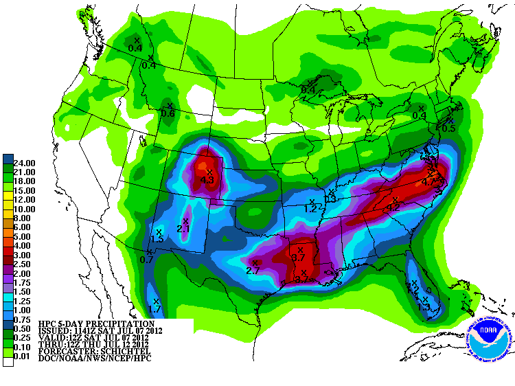
I'm very encouraged by the Saturday morning 5-day QPF prog out of the Hydrometeorological Prediction Center (HPC). Ample rainfall for many of us who are desperate for the wet stuff! :cheesy:

So hoping this verifies ... it's been since mid May when Austin has seen any rainfall worth mentioning.
0 likes   
Any forecasts under my name are to be taken with a grain of salt. Get your best forecasts from the National Weather Service and National Hurricane Center.

User avatar
Rgv20
S2K Supporter
S2K Supporter
Posts: 2466
Age: 38
Joined: Wed Jan 05, 2011 5:42 pm
Location: Edinburg/McAllen Tx

#278 Postby Rgv20 » Sat Jul 07, 2012 11:29 am

Sure thing Porta it looks nice! If only it could expand more to the south...Looking at the 0zECMWF it tries to expand the rain more to the south than the HPC is currently forecasting so we shall see what happens. :D

Image
0 likes   
The following post is NOT an official forecast and should not be used as such. It is just the opinion of the poster and may or may not be backed by sound meteorological data. It is NOT endorsed by any professional institution including storm2k.org For Official Information please refer to the NHC and NWS products.

User avatar
Portastorm
Storm2k Moderator
Storm2k Moderator
Posts: 9914
Age: 62
Joined: Fri Jul 11, 2003 9:16 am
Location: Round Rock, TX
Contact:

Re: Texas Summer 2012

#279 Postby Portastorm » Sat Jul 07, 2012 2:39 pm

So I see (the 12z Euro). That would bring a little more "fun" for you Rgv20!

Well, it's 2:38 pm Saturday and I see convective activity to my north at about 20 miles. Moving slowly southwest. The only question now is will the Great Austin Rain Shield be activated and evaporate the rain or will it be de-activated, bringing joy and happiness at the Portastorm Weather Center in scenic southwest Travis County.
0 likes   
Any forecasts under my name are to be taken with a grain of salt. Get your best forecasts from the National Weather Service and National Hurricane Center.

weatherdude1108
Category 5
Category 5
Posts: 4228
Joined: Tue Dec 13, 2011 1:04 pm
Location: Northwest Austin/Cedar Park, TX

#280 Postby weatherdude1108 » Sat Jul 07, 2012 4:00 pm

Just had a nice DOWNPOUR from a couple scattered cells on the north side of Austin! :rain: Checked the gauge (out in the open away from trees and structures). It measured 0.2-inch just from this little cell! Just finished trimming dry yard a couple hours ago! Perfect timing! :D I'm hoping this is just a preview of things to come. :wink:
0 likes   


Return to “USA & Caribbean Weather”

Who is online

Users browsing this forum: South Texas Storms, TexasF6 and 45 guests