Texas Summer 2012

U.S. & Caribbean Weather Discussions and Severe Weather Events

Moderator: S2k Moderators

Forum rules

The posts in this forum are NOT official forecast and should not be used as such. They are just the opinion of the poster and may or may not be backed by sound meteorological data. They are NOT endorsed by any professional institution or STORM2K.

Help Support Storm2K
Message
Author
User avatar
Portastorm
Storm2k Moderator
Storm2k Moderator
Posts: 9914
Age: 62
Joined: Fri Jul 11, 2003 9:16 am
Location: Round Rock, TX
Contact:

Re:

#281 Postby Portastorm » Sat Jul 07, 2012 4:04 pm

weatherdude1108 wrote:Just had a nice DOWNPOUR from a couple scattered cells on the north side of Austin! :rain: Checked the gauge (out in the open away from trees and structures). It measured 0.2-inch just from this little cell! Just finished trimming dry yard a couple hours ago! Perfect timing! :D I'm hoping this is just a preview of things to come. :wink:


Hey ... that's great ... now blow it down south so it can rain here! :wink:
0 likes   
Any forecasts under my name are to be taken with a grain of salt. Get your best forecasts from the National Weather Service and National Hurricane Center.

weatherdude1108
Category 5
Category 5
Posts: 4228
Joined: Tue Dec 13, 2011 1:04 pm
Location: Northwest Austin/Cedar Park, TX

Re: Re:

#282 Postby weatherdude1108 » Sat Jul 07, 2012 4:06 pm

Portastorm wrote:
weatherdude1108 wrote:Just had a nice DOWNPOUR from a couple scattered cells on the north side of Austin! :rain: Checked the gauge (out in the open away from trees and structures). It measured 0.2-inch just from this little cell! Just finished trimming dry yard a couple hours ago! Perfect timing! :D I'm hoping this is just a preview of things to come. :wink:


Hey ... that's great ... now blow it down south so it can rain here! :wink:


I'm working on it portastorm. :wink:
0 likes   

User avatar
somethingfunny
ChatStaff
ChatStaff
Posts: 3926
Age: 36
Joined: Thu May 31, 2007 10:30 pm
Location: McKinney, Texas

#283 Postby somethingfunny » Sat Jul 07, 2012 4:42 pm

It's raining here in Garland! Temp dropped from 101 to 76 in my backyard. This year's July beats the HECK out of last July!
0 likes   
I am not a meteorologist, and any posts made by me are not official forecasts or to be interpreted as being intelligent. These posts are just my opinions and are probably silly opinions.

User avatar
Portastorm
Storm2k Moderator
Storm2k Moderator
Posts: 9914
Age: 62
Joined: Fri Jul 11, 2003 9:16 am
Location: Round Rock, TX
Contact:

Re: Texas Summer 2012

#284 Postby Portastorm » Sat Jul 07, 2012 5:34 pm

I've also seen some reports on Twitter about power outages in the Metroplex as a result of a gust front outflow from storms and some damage.
0 likes   
Any forecasts under my name are to be taken with a grain of salt. Get your best forecasts from the National Weather Service and National Hurricane Center.

User avatar
Texas Snowman
Storm2k Moderator
Storm2k Moderator
Posts: 6151
Joined: Fri Jan 25, 2008 11:29 am
Location: Denison, Texas

Re: Texas Summer 2012

#285 Postby Texas Snowman » Sat Jul 07, 2012 9:42 pm

Portastorm wrote:I've also seen some reports on Twitter about power outages in the Metroplex as a result of a gust front outflow from storms and some damage.


In addition to the power outages, a potentially tragic afternoon in the DFW Metroplex thanks to those t-storm outflow winds. Several people are missing in area lakes (White Rock, Lewisville, Ray Hubbard) according to WFAA-TV.

http://www.wfaa.com/news/local/Search-a ... 81335.html
Last edited by Texas Snowman on Sat Jul 07, 2012 9:44 pm, edited 1 time in total.
0 likes   
The above post and any post by Texas Snowman is NOT an official forecast and should not be used as such. It is just the opinion of the poster and may or may not be backed by sound meteorological data. It is NOT endorsed by any professional institution including storm2k.org. For official information, please refer to NWS products.

User avatar
Texas Snowman
Storm2k Moderator
Storm2k Moderator
Posts: 6151
Joined: Fri Jan 25, 2008 11:29 am
Location: Denison, Texas

#286 Postby Texas Snowman » Sat Jul 07, 2012 9:43 pm

Those outflow winds came out of a cluster of t-storms that moved through Fannin, Grayson, and Hunt counties this afternoon with some heavy rains.

About an inch of rain fell in portions of Grayson County.
0 likes   
The above post and any post by Texas Snowman is NOT an official forecast and should not be used as such. It is just the opinion of the poster and may or may not be backed by sound meteorological data. It is NOT endorsed by any professional institution including storm2k.org. For official information, please refer to NWS products.

User avatar
Portastorm
Storm2k Moderator
Storm2k Moderator
Posts: 9914
Age: 62
Joined: Fri Jul 11, 2003 9:16 am
Location: Round Rock, TX
Contact:

Re: Texas Summer 2012

#287 Postby Portastorm » Sun Jul 08, 2012 11:40 am

Hoping we have better "luck" today at the Portastorm Weather Center in scenic southwest Travis County in terms of getting wet. Yesterday, I counted about 25 raindrops around 5 p.m. as I watched some beautiful cumulonimbus clouds move east to west to my north. :(

The forecast from NWSFO Austin/San Antonio includes decent rainfall chances for much of the week.
0 likes   
Any forecasts under my name are to be taken with a grain of salt. Get your best forecasts from the National Weather Service and National Hurricane Center.

User avatar
vbhoutex
Storm2k Executive
Storm2k Executive
Posts: 29096
Age: 73
Joined: Wed Oct 09, 2002 11:31 pm
Location: Cypress, TX
Contact:

Re: Texas Summer 2012

#288 Postby vbhoutex » Sun Jul 08, 2012 3:01 pm

Rain on and off all day here in Houston. I am a happy weather weenie!! :cheesy: :rain: :rain:
0 likes   
Skywarn, C.E.R.T.
Please click below to donate to STORM2K to help with the expenses of keeping the site going:
Image

User avatar
Rgv20
S2K Supporter
S2K Supporter
Posts: 2466
Age: 38
Joined: Wed Jan 05, 2011 5:42 pm
Location: Edinburg/McAllen Tx

#289 Postby Rgv20 » Sun Jul 08, 2012 7:27 pm

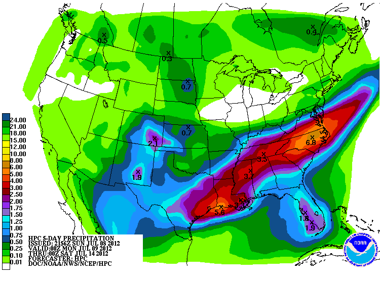
This is the latest HPC forecast Rainfall valid thru Friday Evening....Looks like a wet work week for vbhoutex area!

Image
0 likes   
The following post is NOT an official forecast and should not be used as such. It is just the opinion of the poster and may or may not be backed by sound meteorological data. It is NOT endorsed by any professional institution including storm2k.org For Official Information please refer to the NHC and NWS products.

User avatar
vbhoutex
Storm2k Executive
Storm2k Executive
Posts: 29096
Age: 73
Joined: Wed Oct 09, 2002 11:31 pm
Location: Cypress, TX
Contact:

Re: Texas Summer 2012

#290 Postby vbhoutex » Sun Jul 08, 2012 7:45 pm

:uarrow: :uarrow: We are hearing 4"-6" for the week which looks like what SPC shows. I don't want to look a gift horse in the mouth, but can't we spread it out over maybe 2 weeks? :cheesy:
0 likes   
Skywarn, C.E.R.T.
Please click below to donate to STORM2K to help with the expenses of keeping the site going:
Image

User avatar
~FlipFlopGirl~
Tropical Depression
Tropical Depression
Posts: 52
Age: 46
Joined: Sat Jul 24, 2010 7:43 pm
Location: Waco,TX

#291 Postby ~FlipFlopGirl~ » Sun Jul 08, 2012 9:09 pm

Temple had lightening strike a transformer at the Water treatment plant and needless to say it was a disaster declaration- mandatory water restrictions and businesses were forced to close- Makes you think of how prepared you would be you were in the same boat- We did have fun running through the rain pushing our cart of groceries today! Rain is never a problem in Texas especially during July :sun:
0 likes   

User avatar
horselattitudesfarm
Category 1
Category 1
Posts: 315
Joined: Thu Jul 16, 2009 5:55 pm
Location: Asheville, NC (formerly from Dallas, TX)

#292 Postby horselattitudesfarm » Mon Jul 09, 2012 8:43 am

Is Portastorm still high and dry? I bet the Austin Rain Shield isn't as strong as the one over our farm down near Luling. After all, I don't call it Horselatitudes Farm for nothing! 8-) :)
0 likes   

User avatar
Portastorm
Storm2k Moderator
Storm2k Moderator
Posts: 9914
Age: 62
Joined: Fri Jul 11, 2003 9:16 am
Location: Round Rock, TX
Contact:

Re:

#293 Postby Portastorm » Mon Jul 09, 2012 1:59 pm

horselattitudesfarm wrote:Is Portastorm still high and dry? I bet the Austin Rain Shield isn't as strong as the one over our farm down near Luling. After all, I don't call it Horselatitudes Farm for nothing! 8-) :)


Funny you should mention that, horselatitudesfarm ... there was a significant amount of water falling on my lawn last evening ... because I was running my sprinklers!! :x

We had maybe five minutes of rain. Worse yet, I saw dark clouds to my north, northeast, and south and they all moved away in one direction or another. I can tell you that southwest and south Austin didn't get squat yesterday in the rainfall department.

I'm sorry for Luling. Y'all need lots of rain so the Watermelon Thump can show off some tasty melons for us cityfolk!
0 likes   
Any forecasts under my name are to be taken with a grain of salt. Get your best forecasts from the National Weather Service and National Hurricane Center.

weatherdude1108
Category 5
Category 5
Posts: 4228
Joined: Tue Dec 13, 2011 1:04 pm
Location: Northwest Austin/Cedar Park, TX

Re: Re:

#294 Postby weatherdude1108 » Mon Jul 09, 2012 3:33 pm

Portastorm wrote:
horselattitudesfarm wrote:Is Portastorm still high and dry? I bet the Austin Rain Shield isn't as strong as the one over our farm down near Luling. After all, I don't call it Horselatitudes Farm for nothing! 8-) :)


Funny you should mention that, horselatitudesfarm ... there was a significant amount of water falling on my lawn last evening ... because I was running my sprinklers!! :x

We had maybe five minutes of rain. Worse yet, I saw dark clouds to my north, northeast, and south and they all moved away in one direction or another. I can tell you that southwest and south Austin didn't get squat yesterday in the rainfall department.

I'm sorry for Luling. Y'all need lots of rain so the Watermelon Thump can show off some tasty melons for us cityfolk!


I heard a steady pitter patter on the roof this morning around 5am. Lasted a solid 10 or so minutes.
Got 0.10 out of it! :) The rain shield is bound to be compromised at some point Portastorm. Hang in there! :wink:
0 likes   

weatherdude1108
Category 5
Category 5
Posts: 4228
Joined: Tue Dec 13, 2011 1:04 pm
Location: Northwest Austin/Cedar Park, TX

#295 Postby weatherdude1108 » Mon Jul 09, 2012 3:59 pm

I'm looking at the radar, and there appears to be a rain shield over the Dallas area, down I35 towards Austin and San Antonio. Rain showing on both sides of the interstate.

What a shock! :P
0 likes   

User avatar
Portastorm
Storm2k Moderator
Storm2k Moderator
Posts: 9914
Age: 62
Joined: Fri Jul 11, 2003 9:16 am
Location: Round Rock, TX
Contact:

Re:

#296 Postby Portastorm » Mon Jul 09, 2012 5:25 pm

weatherdude1108 wrote:I'm looking at the radar, and there appears to be a rain shield over the Dallas area, down I35 towards Austin and San Antonio. Rain showing on both sides of the interstate.

What a shock! :P


At about 5:30 pm, radar shows a healthy blob of rain to our immediate north moving south. (Fingers crossed). We did have a 5-minute rainshower at the Portastorm Weather Center earlier this afternoon.
0 likes   
Any forecasts under my name are to be taken with a grain of salt. Get your best forecasts from the National Weather Service and National Hurricane Center.

User avatar
Longhornmaniac8
Category 1
Category 1
Posts: 254
Joined: Thu Nov 18, 2010 2:30 am
Location: Austin, TX

Re: Texas Summer 2012

#297 Postby Longhornmaniac8 » Mon Jul 09, 2012 6:04 pm

I'm sure it's already been discussed, but could someone either briefly explain what's causing this instability resulting in these showers, or point me in the direction of a post that does? With the winds coming from the north, are we now on the backside of a stalled low pressure system?
0 likes   

User avatar
jasons2k
Storm2k Executive
Storm2k Executive
Posts: 8238
Age: 51
Joined: Wed Jul 06, 2005 12:32 pm
Location: The Woodlands, TX

Re: Texas Summer 2012

#298 Postby jasons2k » Mon Jul 09, 2012 6:11 pm

WWUS54 KEWX 092309
SVSEWX

SEVERE WEATHER STATEMENT
NATIONAL WEATHER SERVICE AUSTIN/SAN ANTONIO TX
609 PM CDT MON JUL 9 2012

TXC453-491-092345-
/O.CON.KEWX.SV.W.0100.000000T0000Z-120709T2345Z/
TRAVIS TX-WILLIAMSON TX-
609 PM CDT MON JUL 9 2012

...A SEVERE THUNDERSTORM WARNING REMAINS IN EFFECT UNTIL 645 PM CDT
FOR SOUTH CENTRAL WILLIAMSON AND CENTRAL TRAVIS COUNTIES...

AT 559 PM CDT...NWS METEOROLOGISTS CONTINUED TO DETECT A SEVERE
THUNDERSTORM CAPABLE OF PRODUCING QUARTER SIZE HAIL...AND DAMAGING
WINDS IN EXCESS OF 60 MPH. THIS STORM WAS LOCATED NEAR ROUND ROCK...
MOVING SOUTH AT 10 MPH.

THIS IS A LARGE SEVERE THUNDERSTORM...CAPABLE OF PRODUCING SEVERE
WEATHER OVER A SIGNIFICANT PORTION OF NORTHEAST AUSTIN AND THE
ADJACENT COMMUNITIES OF ROUND ROCK AND PFLUGERVILLE. SOME LOCATIONS
IN THE WARNING AREA INCLUDE BRUSHY CREEK...WINDEMERE...WELLS
BRANCH...CAMP MABRY...WEST LAKE HILLS...AND ROLLINGWOOD.
0 likes   

User avatar
vbhoutex
Storm2k Executive
Storm2k Executive
Posts: 29096
Age: 73
Joined: Wed Oct 09, 2002 11:31 pm
Location: Cypress, TX
Contact:

Re: Re:

#299 Postby vbhoutex » Mon Jul 09, 2012 6:15 pm

Portastorm wrote:
weatherdude1108 wrote:I'm looking at the radar, and there appears to be a rain shield over the Dallas area, down I35 towards Austin and San Antonio. Rain showing on both sides of the interstate.

What a shock! :P


At about 5:30 pm, radar shows a healthy blob of rain to our immediate north moving south. (Fingers crossed). We did have a 5-minute rainshower at the Portastorm Weather Center earlier this afternoon.

Is that rain I see moving into Austin? Looks to me like PWC may already be getting a shower? We are dry for the moment, but we are waiting to see if the rains to our North last long enough to make it into the Metro.
Well I guess the last post answered that question. :eek:
0 likes   
Skywarn, C.E.R.T.
Please click below to donate to STORM2K to help with the expenses of keeping the site going:
Image

User avatar
jasons2k
Storm2k Executive
Storm2k Executive
Posts: 8238
Age: 51
Joined: Wed Jul 06, 2005 12:32 pm
Location: The Woodlands, TX

Re: Texas Summer 2012

#300 Postby jasons2k » Mon Jul 09, 2012 6:15 pm

Longhornmaniac8 wrote:I'm sure it's already been discussed, but could someone either briefly explain what's causing this instability resulting in these showers, or point me in the direction of a post that does? With the winds coming from the north, are we now on the backside of a stalled low pressure system?


It's a combination of a few things. The heat ridge up north has broken down and we are caught in a weakness. A trough axis moved west, under the ridge, across the northern gulf states, and is now caught over Texas and has stalled. That continues to pull-in moist, tropical, unstable air over the state. Add to that afternoon heating and some minor disturbances, and we are getting a daily outbreak of scattered storms. In the next few days, a front will move down and drape across the state, increasing the rain threat even more. Hope this helps.
0 likes   


Return to “USA & Caribbean Weather”

Who is online

Users browsing this forum: Cpv17 and 40 guests