Global model runs discussion
Moderator: S2k Moderators
-
cycloneye

- Admin

- Posts: 149481
- Age: 69
- Joined: Thu Oct 10, 2002 10:54 am
- Location: San Juan, Puerto Rico
Re: Global Model Runs Discussion
The 12z package of models didn't had anything of significance in the North Atlantic for the next couple of weeks. Our friend wxman57 may be right about nothing on July but development may occur on the first week of August.
0 likes
Visit the Caribbean-Central America Weather Thread where you can find at first post web cams,radars
and observations from Caribbean basin members Click Here
and observations from Caribbean basin members Click Here
-
Yellow Evan

- Professional-Met

- Posts: 16240
- Age: 27
- Joined: Fri Jul 15, 2011 12:48 pm
- Location: Henderson, Nevada/Honolulu, HI
- Contact:
Re: Global Model Runs Discussion
Cyclenall wrote:wxman57 wrote:An active East Pacific typically signals a quiet western Atlantic season.
In September 2005, what caused both basins to be hyper at the same time? Don't say neutral conditions because that normally doesn't cause such occurrence.
My guess is a lot of tropical waves, with remnant moisture breaking up to develop in the EPAC.
0 likes
-
Cainer

- Tropical Storm

- Posts: 188
- Age: 34
- Joined: Mon May 05, 2008 3:26 pm
- Location: Yarmouth, Nova Scotia
Re: Global Model Runs Discussion
Yellow Evan wrote:Cyclenall wrote:wxman57 wrote:An active East Pacific typically signals a quiet western Atlantic season.
In September 2005, what caused both basins to be hyper at the same time? Don't say neutral conditions because that normally doesn't cause such occurrence.
My guess is a lot of tropical waves, with remnant moisture breaking up to develop in the EPAC.
Off topic, but I thought I'd point out that Sept 2005 in the Atlantic was only slightly above average; 5 storms formed, the same as in July and August of that year and less than in October. I believe I remember reading somewhere that the ACE for September 2006 was actually higher than that of September 2005. So I guess in a sense, the activity was more balanced out between the two basins in September than for the rest of the year, as to why, who knows. Just my two cents.
0 likes
-
somethingfunny

- ChatStaff

- Posts: 3926
- Age: 37
- Joined: Thu May 31, 2007 10:30 pm
- Location: McKinney, Texas
2005 was below average in the Eastern Pacific. Average is 15.3/8.8/4.2 and 2005 was 15/7/2.
And September 2005 in the Atlantic had Rita...
And September 2005 in the Atlantic had Rita...
0 likes
I am not a meteorologist, and any posts made by me are not official forecasts or to be interpreted as being intelligent. These posts are just my opinions and are probably silly opinions.
-
cycloneye
- Admin
- Posts: 149481
- Age: 69
- Joined: Thu Oct 10, 2002 10:54 am
- Location: San Juan, Puerto Rico
Re: Global Model Runs Discussion
The 12z GFS of July 10th has in very long range (July 26) a weak low pressure in the Windward Islands. For sure it will change many times as the runs come by so let's see as the timeframe narrows what will it have and if other models join.

0 likes
Visit the Caribbean-Central America Weather Thread where you can find at first post web cams,radars
and observations from Caribbean basin members Click Here
and observations from Caribbean basin members Click Here
-
cycloneye
- Admin
- Posts: 149481
- Age: 69
- Joined: Thu Oct 10, 2002 10:54 am
- Location: San Juan, Puerto Rico
Re: Global Model Runs Discussion
12z ECMWF has a Moderate to Strong wave moving thru the NE Caribbean around the 20th of July. Again,plenty of time to see this change a lot as the runs go by.

0 likes
Visit the Caribbean-Central America Weather Thread where you can find at first post web cams,radars
and observations from Caribbean basin members Click Here
and observations from Caribbean basin members Click Here
-
wxman57

- Moderator-Pro Met

- Posts: 23174
- Age: 68
- Joined: Sat Jun 21, 2003 8:06 pm
- Location: Houston, TX (southwest)
Re: Global Model Runs Discussion
Like I said after Debby - nothing more until August. Maybe the 8th.
0 likes
-
MGC

- S2K Supporter

- Posts: 5940
- Joined: Sun Mar 23, 2003 9:05 pm
- Location: Pass Christian MS, or what is left.
Re: Global Model Runs Discussion
Still a good bit of shear in the deep tropics....along with a bunch of dry air. I don't see any development in that region for a while....outside chance something might spin up if a MCC moves off the coast and festers...but, this is just conjecture.....MGC
Of course the above is the opinion of MGC and not an official forecast.
Of course the above is the opinion of MGC and not an official forecast.
0 likes
-
tolakram
- Admin
- Posts: 20185
- Age: 62
- Joined: Sun Aug 27, 2006 8:23 pm
- Location: Florence, KY (name is Mark)
Re: Global Model Runs Discussion
GFS actually has something at 120 hours now. GFS 6Z 120H ... no sure thing.

http://moe.met.fsu.edu/tcgengifs/
http://moe.met.fsu.edu/tcgengifs/
0 likes
M a r k
- - - - -
Join us in chat: Storm2K Chatroom Invite. Android and IOS apps also available.
The posts in this forum are NOT official forecasts and should not be used as such. Posts are NOT endorsed by any professional institution or STORM2K.org. For official information and forecasts, please refer to NHC and NWS products.
-
cycloneye
- Admin
- Posts: 149481
- Age: 69
- Joined: Thu Oct 10, 2002 10:54 am
- Location: San Juan, Puerto Rico
Re: Global Model Runs Discussion
Mark,look at 168 hours.  But after that it vanishes.

0 likes
Visit the Caribbean-Central America Weather Thread where you can find at first post web cams,radars
and observations from Caribbean basin members Click Here
and observations from Caribbean basin members Click Here
-
cycloneye
- Admin
- Posts: 149481
- Age: 69
- Joined: Thu Oct 10, 2002 10:54 am
- Location: San Juan, Puerto Rico
Re: Global Model Runs Discussion
Well,at least there is something that can be called consistency from a model about having something and is from the ECMWF that has been showing a Moderate to Strong Wave moving theu the NE Caribbean on the 20th of July. 7 posts above this one (on the 10th of July) I posted the Euro run showing it and this Friday the 13th 12z run continues to show it.

0 likes
Visit the Caribbean-Central America Weather Thread where you can find at first post web cams,radars
and observations from Caribbean basin members Click Here
and observations from Caribbean basin members Click Here
-
Kingarabian

- S2K Supporter
- Posts: 16365
- Joined: Sat Aug 08, 2009 3:06 am
- Location: Honolulu, Hawaii
-
cycloneye
- Admin
- Posts: 149481
- Age: 69
- Joined: Thu Oct 10, 2002 10:54 am
- Location: San Juan, Puerto Rico
Re:
Kingarabian wrote:Cycloneye, lets see how the Wave holds up with that nasty persistent shear in the Caribbean.
Agree on that. Also, it will be important to see how the Saharan Air Layer will be to overcome that.
0 likes
Visit the Caribbean-Central America Weather Thread where you can find at first post web cams,radars
and observations from Caribbean basin members Click Here
and observations from Caribbean basin members Click Here
-
HurricaneFan
- Tropical Storm
- Posts: 192
- Age: 42
- Joined: Tue Jan 18, 2011 6:16 pm
- Location: Anguilla,Leeward Islands 18.3N 63.0W
-
mcheer23

- Professional-Met
- Posts: 441
- Age: 32
- Joined: Sun Jun 24, 2012 8:24 pm
- Location: Sugar Land, Texas
Re: Global Model Runs Discussion
I will go ahead and agree with wxman with nothing till august..
0 likes
-
Rgv20

- S2K Supporter
- Posts: 2466
- Age: 39
- Joined: Wed Jan 05, 2011 5:42 pm
- Location: Edinburg/McAllen Tx
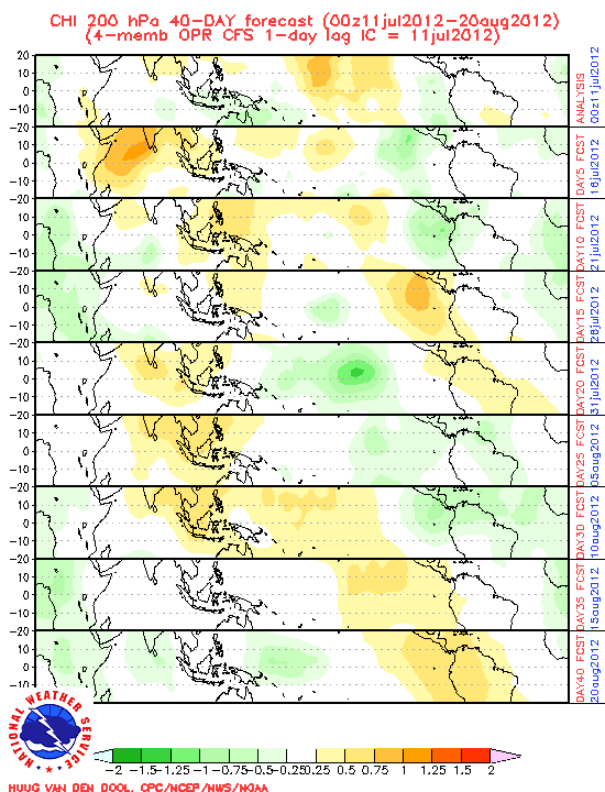
This is the 200HPA forecast from the CFS on 0z7/11/12 basically the green areas indicate strong convergence and the yellow area represent sinking air.....by day 25 and 30 the CFS is forecasting strong convergence in the Caribbean area by the early part of August. So I'm with wxman57 on that the next tropical cyclone could occur by the early part of August.
0 likes
The following post is NOT an official forecast and should not be used as such. It is just the opinion of the poster and may or may not be backed by sound meteorological data. It is NOT endorsed by any professional institution including storm2k.org For Official Information please refer to the NHC and NWS products.


^ Good post. It's the year of home-brews and without the MJO's help the conditions won't be favorable or get systems going. It's over the Indian Ocean in a very weakened state atm. Don't see anything out of the models worth noting in the next 7-10 days.
0 likes
The above post and any post by Ntxw is NOT an official forecast and should not be used as such. It is just the opinion of the poster and may or may not be backed by sound meteorological data. It is NOT endorsed by any professional institution including Storm2k. For official information, please refer to NWS products.
Help support Storm2K!

Who is online
Users browsing this forum: No registered users and 59 guests