2012 WPAC season

This is the general tropical discussion area. Anyone can take their shot at predicting a storms path.

Moderator: S2k Moderators

Forum rules

The posts in this forum are NOT official forecasts and should not be used as such. They are just the opinion of the poster and may or may not be backed by sound meteorological data. They are NOT endorsed by any professional institution or STORM2K. For official information, please refer to products from the National Hurricane Center and National Weather Service.

Help Support Storm2K
Message
Author
euro6208

Re: 2012 WPAC season

#161 Postby euro6208 » Tue Jul 17, 2012 11:18 am

dexterlabio wrote:interesting times. if both Vicente and Saola ever do emerge in the coming days, that would be a big catch up for the first 2 weeks of july with no activity. :lol:


it'll be interesting to track Vicente as it was submitted by our islands (Guam & CNMI). it is a chamorro's man name...the last time it was used was in 2005 for a weak tropical storm that formed in the south china sea that made landfall in vietnam...
0 likes   

User avatar
cycloneye
Admin
Admin
Posts: 145382
Age: 68
Joined: Thu Oct 10, 2002 10:54 am
Location: San Juan, Puerto Rico

Re: 2012 WPAC season

#162 Postby cycloneye » Tue Jul 17, 2012 2:14 pm

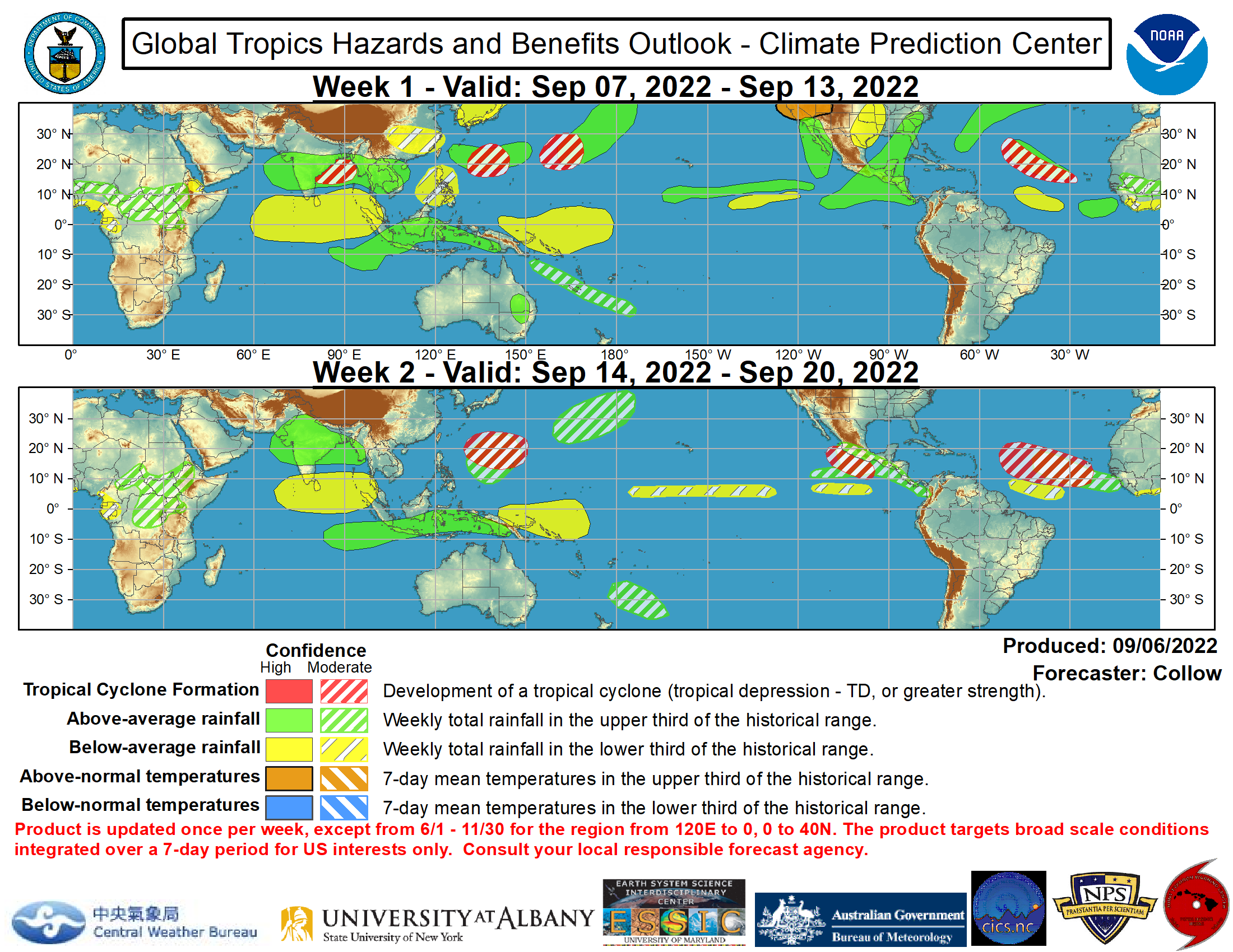
The forecast is for thw WPAC to stay active for the next two weeks.

Image

http://www.cpc.ncep.noaa.gov/products/p ... /ghazards/
0 likes   
Visit the Caribbean-Central America Weather Thread where you can find at first post web cams,radars
and observations from Caribbean basin members Click Here

Typhoon Hunter
WesternPacificWeather.com
Posts: 1221
Joined: Wed Oct 11, 2006 11:37 am
Location: Tokyo
Contact:

#163 Postby Typhoon Hunter » Thu Jul 19, 2012 12:29 am

Latest GFS 00z run develops a potent storm west of Guam which tracks over Okinawa then into E China. In the long range but worth keeping an eye on to see if a trend emerges!
0 likes   
James - Documenting tropical cyclones...

http://www.youtube.com/TyphoonHunter

euro6208

Re: 2012 WPAC season

#164 Postby euro6208 » Sat Jul 21, 2012 12:11 pm

Image

Image

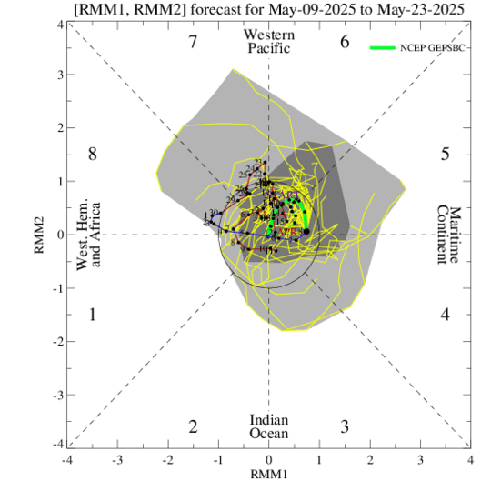
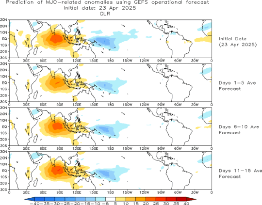
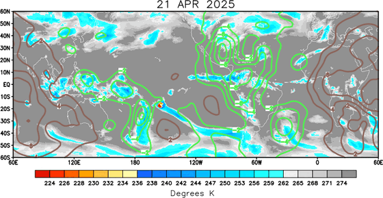
now the mjo is forecast to reach the west pacific sooner...
0 likes   

dexterlabio
Category 5
Category 5
Posts: 3468
Joined: Sat Oct 24, 2009 11:50 pm

Re: 2012 WPAC season

#165 Postby dexterlabio » Sun Jul 22, 2012 11:21 pm

looks like an active phase of the typhoon season next month with the predicted strengthening of the MJO coming to the WPAC throughout August.

Image

Euro now suggesting cyclone genesis by the end of July, could this mean the start of increasing activity next month?
0 likes   
Personal Forecast Disclaimer:
The posts in this forum are NOT official forecast and should not be used as such. They are just the opinion of the poster and may or may not be backed by sound meteorological data. They are NOT endorsed by any professional institution or storm2k.org. For official information, please refer to the NHC and NWS products.

euro6208

Re: 2012 WPAC season

#166 Postby euro6208 » Mon Jul 23, 2012 11:06 am

Image

Image

looks like hong kong might see a very powerful typhoon yet again on the heels of typhoon vicente. note east of luzon philippines is a very large tropical cyclone in the first week of august...
0 likes   

euro6208

Re: 2012 WPAC season

#167 Postby euro6208 » Wed Jul 25, 2012 12:09 pm

Image

very active period for our area with multiple hits from tropical cyclones

Week 1: Enhanced convection and warmer-than-normal SSTs support elevated chances for tropical cyclone development in the western Pacific.

Week 2: Above-normal rainfall is expected to continue across the Philippines, western Pacific, and may extend north to South Korea and southern Japan depending on the track of expected tropical cyclone activity. Elevated chances for tropical cyclone development are forecast in the South China Sea and western Pacific.

all of this in response to a weak mjo over the maritime continent and possibly shifting to the western pacific...

Image

let the mayhem begin!

Image
0 likes   

Typhoon Hunter
WesternPacificWeather.com
Posts: 1221
Joined: Wed Oct 11, 2006 11:37 am
Location: Tokyo
Contact:

Re: 2012 WPAC season

#168 Postby Typhoon Hunter » Wed Jul 25, 2012 8:01 pm

Interesting times ahead for sure Euro, I think 93W will be the next big player, especially since many models hinting at it making landfall somewhere between Okinawa and N Luzon. I think the action will shift closer to you in Guam in the 'ber months! Especially October onwards!
0 likes   
James - Documenting tropical cyclones...

http://www.youtube.com/TyphoonHunter

euro6208

Re: 2012 WPAC season

#169 Postby euro6208 » Thu Jul 26, 2012 9:51 am

Typhoon Hunter wrote:Interesting times ahead for sure Euro, I think 93W will be the next big player, especially since many models hinting at it making landfall somewhere between Okinawa and N Luzon. I think the action will shift closer to you in Guam in the 'ber months! Especially October onwards!


now that would be exciting :grrr:
0 likes   

euro6208

Re: 2012 WPAC season

#170 Postby euro6208 » Fri Jul 27, 2012 11:12 am

Image

while dry air surrounds the atlantic and east pacific/central pacific, the west pacific is enjoying no dry air...looks like a very favorable environment...
0 likes   

euro6208

Re: 2012 WPAC season

#171 Postby euro6208 » Fri Jul 27, 2012 10:35 pm

looks like euro is developing triplets
0 likes   

Typhoon Hunter
WesternPacificWeather.com
Posts: 1221
Joined: Wed Oct 11, 2006 11:37 am
Location: Tokyo
Contact:

#172 Postby Typhoon Hunter » Sat Jul 28, 2012 8:43 pm

If that next storm forms which ECM is showing will certainly help the numbers game. Currently 2 ahead of average at the moment!
0 likes   
James - Documenting tropical cyclones...

http://www.youtube.com/TyphoonHunter

euro6208

Re:

#173 Postby euro6208 » Sat Jul 28, 2012 10:54 pm

Typhoon Hunter wrote:If that next storm forms which ECM is showing will certainly help the numbers game. Currently 2 ahead of average at the moment!


wow! triplets for sure...saola right into taiwan and possibly eastern china...damrey hitting north of shanghai...and soon *haikui* passing north of okinawa and stalling in the east china sea...all 3 intensifying too...

Image
0 likes   

euro6208

Re: 2012 WPAC season

#174 Postby euro6208 » Sun Jul 29, 2012 10:09 am

crazy run from euro...it seems like mother nature is mad at china and it's major cities!

First, category 4 vicente rapidly intensifies and hits south west of macao/hongkong...

Second, saola is barreling down on taiwan and eastern china (category 3 maybe soon?)

Third, Damrey is expected to hit east of beijing possibly as a tropical storm or even typhoon

and now, our next tropical cyclone is expected to hit south of shanghai as a tropical storm but is long range...

millions and millions of people will be affected and i didn't even include many more mega cities! i'm just familiar with the above cities :D
0 likes   

dexterlabio
Category 5
Category 5
Posts: 3468
Joined: Sat Oct 24, 2009 11:50 pm

Re: 2012 WPAC season

#175 Postby dexterlabio » Wed Aug 01, 2012 9:15 am

northwestern pacific looks so cloudy with our 2 TC's and an invest. MJO at work. :lol:
0 likes   
Personal Forecast Disclaimer:
The posts in this forum are NOT official forecast and should not be used as such. They are just the opinion of the poster and may or may not be backed by sound meteorological data. They are NOT endorsed by any professional institution or storm2k.org. For official information, please refer to the NHC and NWS products.

euro6208

Re: 2012 WPAC season

#176 Postby euro6208 » Wed Aug 01, 2012 11:36 am

Image

Image

During Week-1, the weak MJO signal and ongoing tropical cyclones increase chances for rainfall in the upper tercile across eastern China, Taiwan, and the western Pacific. Enhanced convection and warmer-than-normal SSTs support elevated chances for tropical cyclone development in the western Pacific.

The week-2 outlook is more uncertain due to a continued weak MJO signal. Above-normal rainfall and elevated odds for tropical cyclone development are expected to continue across the western Pacific.
0 likes   

euro6208

Re: 2012 WPAC season

#177 Postby euro6208 » Thu Aug 02, 2012 11:35 am

looks like euro is developing another tropical cyclone right behind Invest 99W or Northeast of guam then develops very slowly north of wake island ...
0 likes   

euro6208

Re: 2012 WPAC season

#178 Postby euro6208 » Thu Aug 02, 2012 12:23 pm

Image

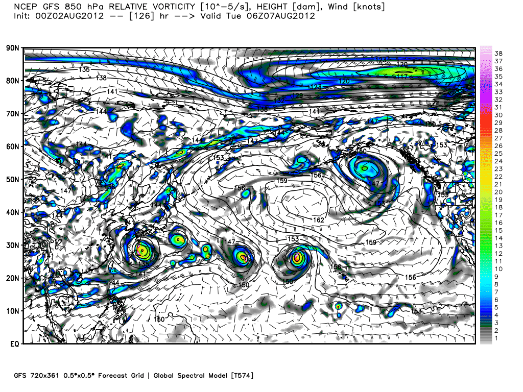
forecast for august 6...4 tropical cyclones in the west pacific and 1 in the central pacific...looks like a very very active west pacific with more landfalls coming...

it's a shame or rather an embarassment that the west pacific with all of these powerful typhoons and many activity every year has no recon ( with many of them making landfall over very populated areas) while one basin occasional has only 1 or 2 major hurricane but with recon... :lol: :roll:
0 likes   

euro6208

Re: 2012 WPAC season

#179 Postby euro6208 » Fri Aug 03, 2012 12:19 pm

Twitter:

Ryan N. Maue ‏@RyanMaue
If GFS pans out, JTWC will be dealing with 5 more named tropical storms in the next 8-days. Binary & triples

euro still showring haikui developing into a powerful monster typhoon while 90W (currently active) forecast to strengthen to a typhoon and yet another system, north of guam, according to euro will also develop into a typhoon...crazy...
0 likes   

euro6208

Re: 2012 WPAC season

#180 Postby euro6208 » Mon Aug 06, 2012 12:26 pm

Final Update from Tropical Storm Risk for 2012 http://www.tropicalstormrisk.com

August Update- 27/17/9

same from last month so a super season is still forecast...


There is a 46% probability that the 2012 NW Pacific typhoon season ACE index will be above-average
(defined as an ACE index value in the upper tercile historically (>336)), a 40% likelihood it will be nearnormal (defined as an ACE index value in the middle tercile historically (235 to 336) and only a 14%
chance it will be below-normal (defined as an ACE index value in the lower tercile historically (<235))
0 likes   


Return to “Talkin' Tropics”

Who is online

Users browsing this forum: hurricanes1234, Stratton23, TampaWxLurker, TomballEd and 58 guests