Texas Summer 2012

U.S. & Caribbean Weather Discussions and Severe Weather Events

Moderator: S2k Moderators

Forum rules

The posts in this forum are NOT official forecast and should not be used as such. They are just the opinion of the poster and may or may not be backed by sound meteorological data. They are NOT endorsed by any professional institution or STORM2K.

Help Support Storm2K
Message
Author
User avatar
South Texas Storms
Professional-Met
Professional-Met
Posts: 4201
Joined: Thu Jun 24, 2010 12:28 am
Location: Houston, TX

Re: Texas Summer 2012

#381 Postby South Texas Storms » Wed Jul 25, 2012 4:59 pm

Portastorm wrote:
South Texas Storms wrote:When is it gonna rain again? The long range models make me sad. They show no rain through the next 2 weeks :(


September 2012


Boy I sure hope you are wrong! That would be awful. Ntxw, do you see any possible rain events in August?
0 likes   

User avatar
Ntxw
Storm2k Moderator
Storm2k Moderator
Posts: 22731
Joined: Wed Oct 21, 2009 6:34 pm
Location: DFW, Texas

Re: Texas Summer 2012

#382 Postby Ntxw » Wed Jul 25, 2012 6:08 pm

South Texas Storms wrote:Boy I sure hope you are wrong! That would be awful. Ntxw, do you see any possible rain events in August?


Don't see anything substantial first half of August. EPAC hasn't brought moisture towards Texas this season and Atlantic I fear won't help much. Typical August heat until cold fronts start getting closer end of the month. 2006 has been a decent analog summer for Texas and August featured some of the longest duration heat that year. We also probably won't feel the full effects of Nino until Sept. Euro anchors heat ridge over southern plains in foreseeable future.
0 likes   
The above post and any post by Ntxw is NOT an official forecast and should not be used as such. It is just the opinion of the poster and may or may not be backed by sound meteorological data. It is NOT endorsed by any professional institution including Storm2k. For official information, please refer to NWS products.

  Help support Storm2K!
Help Support Storm2K

weatherdude1108
Category 5
Category 5
Posts: 4228
Joined: Tue Dec 13, 2011 1:04 pm
Location: Northwest Austin/Cedar Park, TX

#383 Postby weatherdude1108 » Wed Jul 25, 2012 10:53 pm

0 likes   
The preceding post is NOT an official forecast, and should not be used as such. It is only the opinion of the poster and may or may not be backed by sound meteorological data. It is NOT endorsed by any professional institution including storm2k.org. For Official Information please refer to the NHC and NWS products.

User avatar
Texas Snowman
Storm2k Moderator
Storm2k Moderator
Posts: 6151
Joined: Fri Jan 25, 2008 11:29 am
Location: Denison, Texas

#384 Postby Texas Snowman » Thu Jul 26, 2012 12:53 pm

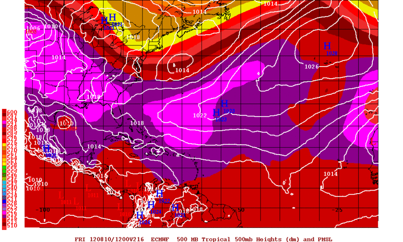
Wxman 57 noted on the Talking Tropics thread that the "Death Ridge" is gone this summer.

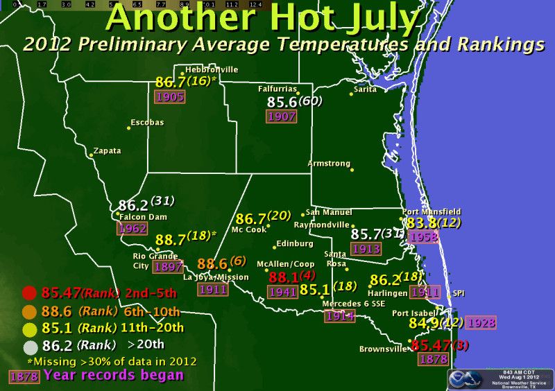
The Gulf is cooking, lots of people are looking for "home-brew" tropical development, and we've already seen a few pesky lows that have brought unexpected rains to portions of Texas.

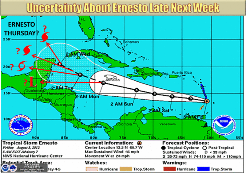
With the heart of the tropical season coming up - August and September - me thinks there will be a surprise or two lurking over the next eight weeks.
0 likes   
The above post and any post by Texas Snowman is NOT an official forecast and should not be used as such. It is just the opinion of the poster and may or may not be backed by sound meteorological data. It is NOT endorsed by any professional institution including storm2k.org. For official information, please refer to NWS products.

User avatar
South Texas Storms
Professional-Met
Professional-Met
Posts: 4201
Joined: Thu Jun 24, 2010 12:28 am
Location: Houston, TX

Re: Texas Summer 2012

#385 Postby South Texas Storms » Thu Jul 26, 2012 8:08 pm

Here is my latest weather article comparing the 2011 and 2012 Texas Droughts! Please check it out!
http://www.examiner.com/article/compari ... s-droughts
0 likes   

User avatar
Rgv20
S2K Supporter
S2K Supporter
Posts: 2466
Age: 38
Joined: Wed Jan 05, 2011 5:42 pm
Location: Edinburg/McAllen Tx

#386 Postby Rgv20 » Thu Jul 26, 2012 9:09 pm

There is a nice lightning show outside....

SEVERE THUNDERSTORM WARNING
TXC427-270230-
/O.NEW.KBRO.SV.W.0087.120727T0149Z-120727T0230Z/

BULLETIN - EAS ACTIVATION REQUESTED
SEVERE THUNDERSTORM WARNING
NATIONAL WEATHER SERVICE BROWNSVILLE TX
849 PM CDT THU JUL 26 2012

THE NATIONAL WEATHER SERVICE IN BROWNSVILLE HAS ISSUED A

* SEVERE THUNDERSTORM WARNING FOR...
WESTERN STARR COUNTY IN DEEP SOUTH TEXAS.

* UNTIL 930 PM CDT

* AT 849 PM CDT...RADAR INDICATED A SEVERE THUNDERSTORM...CAPABLE OF
PRODUCING DESTRUCTIVE 70 MPH WINDS...7 MILES WEST OF ROMA...MOVING
NORTH AT 15 MPH.

* LOCATIONS IN THE WARNING INCLUDE...
FRONTON.
SALINENO.
FALCON DAM.
FALCON HEIGHTS.

THIS STORM WILL ALSO BE CAPABLE OF HAIL TO THE SIZE OF PENNIES.

PRECAUTIONARY/PREPAREDNESS ACTIONS...

WIND GUSTS TO 60 MPH OR MORE WILL CAUSE SOME STRUCTURAL DAMAGE...
MAINLY TO TREES AND POWER LINES. POORLY ANCHORED ROOFS...MOBILE
HOMES...AND SHEDS ARE ALSO AT RISK.

&&

LAT...LON 2656 9917 2663 9907 2650 9889 2639 9901
2641 9903 2639 9908 2643 9912 2647 9910
2649 9910 2652 9913 2653 9916 2655 9918
TIME...MOT...LOC 0149Z 201DEG 13KT 2646 9911

$$

JGG
0 likes   
The following post is NOT an official forecast and should not be used as such. It is just the opinion of the poster and may or may not be backed by sound meteorological data. It is NOT endorsed by any professional institution including storm2k.org For Official Information please refer to the NHC and NWS products.

aggiecutter
Category 5
Category 5
Posts: 1751
Joined: Thu Oct 14, 2004 9:22 pm
Location: Texarkana

Re: Texas Summer 2012

#387 Postby aggiecutter » Fri Jul 27, 2012 10:18 am

2.5" of rain in Texarkana this morning. Add that to the 1.75" we received 10 days ago, and Texarkana is above normal for rainfall for the month of July.
0 likes   

User avatar
Ntxw
Storm2k Moderator
Storm2k Moderator
Posts: 22731
Joined: Wed Oct 21, 2009 6:34 pm
Location: DFW, Texas

#388 Postby Ntxw » Tue Jul 31, 2012 1:47 pm

Ah the dog days of summer continues. Still no changes in that the first half of August will remain hot and dry for most of the state. Wild card continues to be the waves off the African coast but not very confident they will provide much relief for us. PNA remains negative and should straddle neutral for awhile.

Most of the heat this summer has been to the north closer to the ridge (which is weaker and smaller than last year thank goodness). Of course if you're underneath it may not feel that way. Southern half the state has fared much better thanks to wet soil moisture from earlier in the month. Firmly believe that once we turn to Sept summer will end much sooner than the past few seasons. Late July and early August is our peak hot period terms of averages and may be the last hurrah for this summer.

It could be far worse!

100+ days through July 31st

DFW
2012- 15 days
2011- 37 days

Austin Mabry
2012- 10 days (though there were several more 99 days)
2011- 47 days

Houston IAH
2012- 3 days
2011- 11 days

Side note: Westerlies have been progressing eastward in the PAC and is near dateline. Once it arrives (thanks to growing Nino) we'll start to see those famed Baja lows and STJ make an appearance. Fingers crossed!
0 likes   
The above post and any post by Ntxw is NOT an official forecast and should not be used as such. It is just the opinion of the poster and may or may not be backed by sound meteorological data. It is NOT endorsed by any professional institution including Storm2k. For official information, please refer to NWS products.


  Help support Storm2K!

Help Support Storm2K


weatherdude1108
Category 5
Category 5
Posts: 4228
Joined: Tue Dec 13, 2011 1:04 pm
Location: Northwest Austin/Cedar Park, TX

#389 Postby weatherdude1108 » Wed Aug 01, 2012 2:38 pm

Did anyone notice the GFS has a tropical feature headed into Mexico south of Brownsville around August 12th? :eek:
I just saw that.

I know it is a ways off, but anything can happen. :P
0 likes   
The preceding post is NOT an official forecast, and should not be used as such. It is only the opinion of the poster and may or may not be backed by sound meteorological data. It is NOT endorsed by any professional institution including storm2k.org. For Official Information please refer to the NHC and NWS products.

User avatar
Ntxw
Storm2k Moderator
Storm2k Moderator
Posts: 22731
Joined: Wed Oct 21, 2009 6:34 pm
Location: DFW, Texas

Re:

#390 Postby Ntxw » Wed Aug 01, 2012 3:53 pm

weatherdude1108 wrote:Did anyone notice the GFS has a tropical feature headed into Mexico south of Brownsville around August 12th? :eek:
I just saw that.

I know it is a ways off, but anything can happen. :P


Euro has a broad area of low pressure too. Could it be one of the waves currently tracking towards the Carib :wink: ?
0 likes   
The above post and any post by Ntxw is NOT an official forecast and should not be used as such. It is just the opinion of the poster and may or may not be backed by sound meteorological data. It is NOT endorsed by any professional institution including Storm2k. For official information, please refer to NWS products.


  Help support Storm2K!

Help Support Storm2K


User avatar
Rgv20
S2K Supporter
S2K Supporter
Posts: 2466
Age: 38
Joined: Wed Jan 05, 2011 5:42 pm
Location: Edinburg/McAllen Tx

#391 Postby Rgv20 » Wed Aug 01, 2012 7:32 pm

Well it was certainly a warm July in my area.

Image
Another above average month of temperatures is in the books for portions of the Rio Grande Valley as July turns to August. For Brownsville, the monthly average of 85.47 degrees marked the 16th month out of the past 17th above the 30-year average (1981-2010), dating back to March, 2011. How will August fare? The latest forecast indicates equal chances of above average, average, or below average temperatures, but the first week will remain several degrees warmer than it should be. More information at http://www.cpc.noaa.gov .


Looking at the long range TD5 certainly has my attention as it could be a player for the GOM late next week until the weekend (Aug 10-13?)

12zECMWF has TD5 knocking on the door of South Texas by Friday August 10.
Image
0 likes   
The following post is NOT an official forecast and should not be used as such. It is just the opinion of the poster and may or may not be backed by sound meteorological data. It is NOT endorsed by any professional institution including storm2k.org For Official Information please refer to the NHC and NWS products.

User avatar
Ntxw
Storm2k Moderator
Storm2k Moderator
Posts: 22731
Joined: Wed Oct 21, 2009 6:34 pm
Location: DFW, Texas

Re: Texas Summer 2012

#392 Postby Ntxw » Thu Aug 02, 2012 3:05 pm

Image

Core of the heat certainly in the western Red River valley. The good news, ridge will head west and weaken (maybe even for the summer!). Good chance we may have gone over the summit of summer. Another several days of hot temps as it gradually gets less hot with wet weather possible second half of Aug. Cold is starting to show signs in the Arctic with a vortex growing.

Some optimism from FW this morning.

LONG TERM...GFS/ECMWF AGREE THAT THE RIDGE CENTER SLIDES
NORTHWEST INTO COLORADO/UTAH AFTER THE END OF THIS FORECAST
PERIOD. THIS WOULD COOL US OFF A BIT BY SATURDAY THE 11TH. THAT
IS A LONG WAY OFF AND THE SOLUTION MAY CHANGE...BUT HISTORICALLY
MID AUGUST IS JUST PAST THE PEAK OF THE SUMMER TEMPERATURE
MAXIMUM...THIS IS WHEN WE SHOULD BEGIN TO START A SLOW COOL DOWN.
0 likes   
The above post and any post by Ntxw is NOT an official forecast and should not be used as such. It is just the opinion of the poster and may or may not be backed by sound meteorological data. It is NOT endorsed by any professional institution including Storm2k. For official information, please refer to NWS products.


  Help support Storm2K!

Help Support Storm2K


weatherdude1108
Category 5
Category 5
Posts: 4228
Joined: Tue Dec 13, 2011 1:04 pm
Location: Northwest Austin/Cedar Park, TX

#393 Postby weatherdude1108 » Thu Aug 02, 2012 3:13 pm

AREA FORECAST DISCUSSION
NATIONAL WEATHER SERVICE AUSTIN/SAN ANTONIO TX
247 PM CDT THU AUG 2 2012

.DISCUSSION...
THIS AFTERNOON THE UPPER LEVEL HIGH WAS CENTERED OVER NORTHWEST
TEXAS WITH THE ATTENDANT RIDGE OVER SOUTH CENTRAL TEXAS. THE UPPER
LEVEL HIGH WILL REMAIN CAMPED OVER TEXAS FRIDAY AND SATURDAY. WE
WILL CONTINUE TO GO WITH PERSISTENCE USING OUR LOCAL BIAS-CORRECTED
DATABASE FOR THE TEMP FCST. AFTERNOON HIGHS WILL BE 3 TO 5 DEGREES
ABOVE NORMAL WITH A FEW LOCATIONS FLIRTING WITH RECORD HIGHS THIS
AFTERNOON AND FRIDAY.

LATE IN THE WEEKEND THE UPPER LEVEL HIGH WILL SHIFT TO THE WEST
NORTHWEST BECOMING CENTERED OVER THE DESERT SOUTHWEST BY MONDAY.
THIS WILL RESULT IN A SLIGHT LOWERING OF HEIGHT FIELDS ALOFT
ALLOWING FOR AFTERNOON TEMPS TO BE 1 TO 3 DEGREES ABOVE NORMAL BY
EARLY NEXT WEEK. A WEAK INVERTED TROF WILL MOVE WESTWARD UNDER THE
SOUTHERN PERIPHERY OF THE UPPER LEVEL RIDGE. THIS FEATURE MAY
ENHANCE ISOLATED CONVECTION ON THE SEA-BREEZE BOUNDARY EARLY NEXT
WEEK.

TROPICAL DEPRESSION #5 CURRENTLY APPROACHING THE WINDWARD ISLANDS
MAY BRING SOME RELIEF TO SOUTH TEXAS THE WEEKEND OF THE 11TH AND
12TH. THE 12Z GFS HAS THIS FEATURE MOVING ONSHORE ALONG THE LOWER
TEXAS COAST. STILL MANY MORE MODEL RUNS TO GO.
0 likes   
The preceding post is NOT an official forecast, and should not be used as such. It is only the opinion of the poster and may or may not be backed by sound meteorological data. It is NOT endorsed by any professional institution including storm2k.org. For Official Information please refer to the NHC and NWS products.

weatherdude1108
Category 5
Category 5
Posts: 4228
Joined: Tue Dec 13, 2011 1:04 pm
Location: Northwest Austin/Cedar Park, TX

#394 Postby weatherdude1108 » Thu Aug 02, 2012 3:25 pm

Dallas office's discussion on the tropics:

AREA FORECAST DISCUSSION
NATIONAL WEATHER SERVICE FORT WORTH TX
310 PM CDT THU AUG 2 2012

.DISCUSSION...
THE HOT WEATHER WILL CONTINUE TO BE THE MAIN STORY THROUGH THE
NEXT WEEK. CURRENT TEMPERATURES ARE IN THE 97-108 RANGE ACROSS THE
CWA. THE HEAT ADVISORY WAS SET TO EXPIRE THIS EVENING...BUT WENT
AHEAD AND EXTENDED IT FOR ANOTHER 24 HOURS. THE PREVIOUS FORECAST
HAD HIGHS TOMORROW 3-4 DEGREES COOLER THAN TODAY...BUT DO NOT SEE
THIS OCCURRING. 850 WINDS WILL REMAIN FROM THE SSW...WHICH USUALLY
SUPPORTS OUR HOTTEST TEMPERATURES. ALSO...850 TEMPS ARE NEARLY THE
SAME OR JUST SLIGHTLY COOLER. HAVE UPPED THE HIGHS TOMORROW TO
NEARLY THE SAME AS TODAY...MAYBE A DEGREE OR TWO COOLER IN PLACES.
PW VALUES TOMORROW ARE PROJECTED TO BE SLIGHTLY HIGHER...WHICH
COULD LEAD TO HIGHER AFTERNOON DEWPOINTS BY A DEGREE OR TWO AND
HEAT INDICES COULD BE AS HIGH AS 105-109 TOMORROW AFTERNOON FOR
AREAS UNDER THE ADVISORY.

SATURDAY/SUNDAY...850 WINDS WILL BECOME SOUTHERLY AND WE SHOULD
ACTUALLY HAVE SOME COLD AIR ADVECTION AT THIS LEVEL. THIS WOULD
LEAD TO A DECREASE IN AFTERNOON TEMPERATURES BY SEVERAL DEGREES
FOR THE WEEKEND. IT WILL STILL BE HOT WITH HIGHS OVER 100...BUT
NOT THE 105-108 WE HAVE BEEN SEEING FOR SOME LOCATIONS. THE RIDGE
IS EXPECTED TO SHIFT WEST MONDAY...AND WITH HEIGHT FALLS IN OUR
EASTERN ZONES...ISOLATED CONVECTION IS POSSIBLE MONDAY AND
TUESDAY. TD5 REMAINS TO THE EAST OF THE ANTILLES AND SHOULD TRACK
INTO THE CARIBBEAN THIS WEEKEND AND MAY ENTER THE GULF OF MEXICO
BY DAY 7. IT IS STILL TOO EARLY TO DETERMINE ANY AREA FOR LANDFALL
OR THE INTENSITY AT THE TIME OF LANDFALL
...BUT IT BEARS WATCHING
OVER THE NEXT 5-7 DAYS.
0 likes   
The preceding post is NOT an official forecast, and should not be used as such. It is only the opinion of the poster and may or may not be backed by sound meteorological data. It is NOT endorsed by any professional institution including storm2k.org. For Official Information please refer to the NHC and NWS products.

User avatar
Rgv20
S2K Supporter
S2K Supporter
Posts: 2466
Age: 38
Joined: Wed Jan 05, 2011 5:42 pm
Location: Edinburg/McAllen Tx

#395 Postby Rgv20 » Fri Aug 03, 2012 6:10 pm

Going to be a fun weekend for tracking Ernesto!

Image
There remains a good deal of uncertainty on: 1) how strong Ernesto will be when it reaches the Western Caribbean, 2) whether it moves well inland into the Yucatan and dissipates, glances the Yucatan and moves in the Gulf of Mexico as a hurricane, or something in-between. Remember not to concentrate on the exact center of Ernesto, but keep in mind the cone of uncertainty. Where Ernesto eventually goes will determine what happens to it once it moves past the Yucatan. The best thing to do is to stay informed on the latest forecasts, and make sure you are prepared should Ernesto threaten South Texas late next week.
0 likes   
The following post is NOT an official forecast and should not be used as such. It is just the opinion of the poster and may or may not be backed by sound meteorological data. It is NOT endorsed by any professional institution including storm2k.org For Official Information please refer to the NHC and NWS products.

User avatar
Texas Snowman
Storm2k Moderator
Storm2k Moderator
Posts: 6151
Joined: Fri Jan 25, 2008 11:29 am
Location: Denison, Texas

#396 Postby Texas Snowman » Fri Aug 03, 2012 10:33 pm

Posted this on Tropics, think it comes into play here:

I hesitate going against Wxman57's gut call of Mexico, he's pretty good at tropical weather IMO.

But tonight (model runs and NHC nudging track northward) makes me think Texas is very much in play with Ernesto.
0 likes   
The above post and any post by Texas Snowman is NOT an official forecast and should not be used as such. It is just the opinion of the poster and may or may not be backed by sound meteorological data. It is NOT endorsed by any professional institution including storm2k.org. For official information, please refer to NWS products.

User avatar
Portastorm
Storm2k Moderator
Storm2k Moderator
Posts: 9914
Age: 62
Joined: Fri Jul 11, 2003 9:16 am
Location: Round Rock, TX
Contact:

#397 Postby Portastorm » Sat Aug 04, 2012 9:14 am

Well, FWIW, our friend JB is thinking Ernesto will be a threat to South Texas. We shall see.
0 likes   
Any forecasts under my name are to be taken with a grain of salt. Get your best forecasts from the National Weather Service and National Hurricane Center.

User avatar
Rgv20
S2K Supporter
S2K Supporter
Posts: 2466
Age: 38
Joined: Wed Jan 05, 2011 5:42 pm
Location: Edinburg/McAllen Tx

#398 Postby Rgv20 » Sat Aug 04, 2012 9:36 am

:uarrow: As of this morning HPC agree with JB..

Image
0 likes   
The following post is NOT an official forecast and should not be used as such. It is just the opinion of the poster and may or may not be backed by sound meteorological data. It is NOT endorsed by any professional institution including storm2k.org For Official Information please refer to the NHC and NWS products.

User avatar
Portastorm
Storm2k Moderator
Storm2k Moderator
Posts: 9914
Age: 62
Joined: Fri Jul 11, 2003 9:16 am
Location: Round Rock, TX
Contact:

Re: Texas Summer 2012

#399 Postby Portastorm » Sat Aug 04, 2012 9:38 am

Providing our "friend" Ernie expands his girth, that could sling a lot of welcomed moisture to the Valley, and maybe a general South Texas impact.
0 likes   
Any forecasts under my name are to be taken with a grain of salt. Get your best forecasts from the National Weather Service and National Hurricane Center.

User avatar
Rgv20
S2K Supporter
S2K Supporter
Posts: 2466
Age: 38
Joined: Wed Jan 05, 2011 5:42 pm
Location: Edinburg/McAllen Tx

#400 Postby Rgv20 » Sat Aug 04, 2012 9:45 am

My gut feeling on the second landfall is around Tampico, hopefully Ernesto does not explode on the Western GOM as he should be on a good environment.

Here is this morning discussion from the HPC

PRELIMINARY EXTENDED FORECAST DISCUSSION
NWS HYDROMETEOROLOGICAL PREDICTION CENTER CAMP SPRINGS MD
959 AM EDT SAT AUG 04 2012

VALID 12Z WED AUG 08 2012 - 12Z SAT AUG 11 2012

...ERNESTO MOVES THROUGH THE SOUTHERN GULF OF MEXICO THIS PERIOD...

A MAJOR WRINKLE IN THE FORECAST THIS PERIOD IS TROPICAL STORM
ERNESTO...EXPECTED TO BECOME HURRICANE ERNESTO. THE GLOBAL
ENSEMBLE GUIDANCE MOVES THE SYSTEM INTO CENTRAL AMERICA/BELIZE ON
DY 5...AND THROUGH THE BAY OF CAMPECHE TOWARDS EAST-CENTRAL MEXICO
DY 6/7. WHILE WE DO SEE THE TYPICAL NORTH TO SOUTH SPREAD IN THE
TRACK GUIDANCE BY DY 6/7...THE CLUSTERING AROUND THE MEAN AND
TRACKS WITHIN THE OPERATIONAL GFS/ECMWF HAVE BEEN REASONABLY
CONSISTENT FROM RUN TO RUN. WITH THE CYCLONE BEGINNING ITS LIFE IN
THE CENTRAL CARIBBEAN...IT IS LESS LIKELY TO BE INFLUENCED BY
NORTHERN STREAM TROUGHING IN THE EASTERN U.S. AT LEAST THROUGH DY
5/6. THIS GIVES US AT LEAST SOME CONFIDENCE IN EXTRAPOLATING A DY
6/7 POSITION OVER THE WESTERN GULF...TO THE SOUTH OF THE TEXAS
COAST. STILL
...ANY POTENTIAL LANDFALL IN THE U.S. OR MEXICO WOULD
OCCUR NEAR THE END OF THE 7 DAY PERIOD...MEANING THERE IS STILL A
WIDE RANGE OF POSSIBILITIES...AND INTERESTS ALONG THE GULF COAST
WILL NEED TO CLOSELY MONITOR THE OFFICIAL FORECAST FROM THE
NATIONAL HURRICANE CENTER.
0 likes   
The following post is NOT an official forecast and should not be used as such. It is just the opinion of the poster and may or may not be backed by sound meteorological data. It is NOT endorsed by any professional institution including storm2k.org For Official Information please refer to the NHC and NWS products.


Return to “USA & Caribbean Weather”

Who is online

Users browsing this forum: 869MB, Cpv17 and 45 guests