ATL: ERNESTO - Post-Tropical

Moderator: S2k Moderators

Message
Author
hurricanes1234
Category 5
Category 5
Posts: 2907
Joined: Sat Jul 28, 2012 6:19 pm
Location: Trinidad and Tobago

Re: ATL: INVEST 99L

#221 Postby hurricanes1234 » Tue Jul 31, 2012 8:52 pm

JonathanBelles wrote:My thought's tonight on 99L. Better surface circulation, slightly worse upper level circulation and flow. Caribbean threat.

http://jonathanbelles.wordpress.com/201 ... -slightly/


You're absolutely right, the latest images show that the outflow has deteriorated slightly, however, this should not interfere with the development, as long as the system stays in a low shear, moist environment with warm SSTs.
0 likes   
PLEASE NOTE: With the exception of information from weather agencies that I may copy and paste here, my posts will NEVER be official, since I am NOT a meteorologist. They are solely my amateur opinion, and may or may not be accurate. Therefore, please DO NOT use them as official details, particularly when making important decisions. Thank you.

Zanthe
Tropical Storm
Tropical Storm
Posts: 149
Age: 30
Joined: Sat May 26, 2012 9:26 pm
Location: New Castle, PA

Re: ATL: INVEST 99L

#222 Postby Zanthe » Tue Jul 31, 2012 8:54 pm

hurricanes1234 wrote:Just yesterday, the same 99L was an open, ragged-looking, weak area of disturbed weather with shallow convection encircling a barely noticeable center. Now, look at it. It is growing and is now a compact, organized low with the convection neatly placed in the center. By 2 am tomorrow, this might be a 60-70% chance of TC formation within 48 hours.

Personal Forecast Disclaimer:
The posts in this forum are NOT official forecast and should not be used as such. They are just the opinion of the poster and may or may not be backed by sound meteorological data. They are NOT endorsed by any professional institution or storm2k.org. For official information, please refer to the NHC and NWS products.

edit by tolakram, added disclaimer

The disclaimer is required when making predictions.


I agree. Given it has a 50% chance now, I really do expect it to be up'd to at least a 60 if things keep going how they have been.
0 likes   
I'm no expert, everything I say should be taken with a large amount of salt. I could easily be very, very wrong.
~Zanthe Go Coyotes~

User avatar
Rgv20
S2K Supporter
S2K Supporter
Posts: 2466
Age: 38
Joined: Wed Jan 05, 2011 5:42 pm
Location: Edinburg/McAllen Tx

#223 Postby Rgv20 » Tue Jul 31, 2012 9:05 pm

Below is the 12zECMWF Ensemble mean and spread.


By next Tuesday morning the Ensembles start to disagree on the Sea Level pressure in the NW Caribbean as indicated by the bright purple colors.
Image


By next Friday morning as you can see some of the Euro Ensemble members hint at a possible area of Low pressure in the SW GOM....The operational 12zECMWF showed 99L trying to organize in the Western Gulf at the end of its run.
Image
0 likes   
The following post is NOT an official forecast and should not be used as such. It is just the opinion of the poster and may or may not be backed by sound meteorological data. It is NOT endorsed by any professional institution including storm2k.org For Official Information please refer to the NHC and NWS products.

Stormlover2012
Category 1
Category 1
Posts: 262
Joined: Sat Jun 23, 2012 11:03 am

Re: ATL: INVEST 99L - Models

#224 Postby Stormlover2012 » Tue Jul 31, 2012 9:07 pm

thanks good stuff!!
0 likes   

ozonepete
Professional-Met
Professional-Met
Posts: 4743
Joined: Mon Sep 07, 2009 3:23 pm
Location: From Ozone Park, NYC / Now in Brooklyn, NY

Re: ATL: INVEST 99L

#225 Postby ozonepete » Tue Jul 31, 2012 9:07 pm

hurricanes1234 wrote:Just yesterday, the same 99L was an open, ragged-looking, weak area of disturbed weather with shallow convection encircling a barely noticeable center. Now, look at it. It is growing and is now a compact, organized low with the convection neatly placed in the center. By 2 am tomorrow, this might be a 60-70% chance of TC formation within 48 hours.

Personal Forecast Disclaimer:
The posts in this forum are NOT official forecast and should not be used as such. They are just the opinion of the poster and may or may not be backed by sound meteorological data. They are NOT endorsed by any professional institution or storm2k.org. For official information, please refer to the NHC and NWS products.


I think most of us would agree with you, given the low shear, high SSTs and continued slow but steady progress with its organization.

Oops! I thought you said 2PM. By 2AM? Less likely but not impossible.
0 likes   

ozonepete
Professional-Met
Professional-Met
Posts: 4743
Joined: Mon Sep 07, 2009 3:23 pm
Location: From Ozone Park, NYC / Now in Brooklyn, NY

Re: ATL: INVEST 99L

#226 Postby ozonepete » Tue Jul 31, 2012 9:16 pm

Continues to consolidate.

Image
0 likes   

hurricanes1234
Category 5
Category 5
Posts: 2907
Joined: Sat Jul 28, 2012 6:19 pm
Location: Trinidad and Tobago

Re: ATL: INVEST 99L

#227 Postby hurricanes1234 » Tue Jul 31, 2012 9:21 pm

The following post is NOT an official forecast and should not be used as such. It is just the opinion of the poster and may or may not be backed by sound meteorological data. It is NOT endorsed by any professional institution including storm2k.org. For Official Information please refer to the NHC and NWS products.


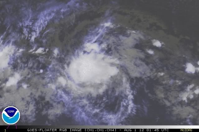
99L seems to be moving relatively fast, and has recently taken on a due west path. If this continues, the storm may be one of those systems that stay far south, like Ivan in 2004. Whatever the case may be, this system is surely getting its act together, despite the low latitude. I wouldn't be overly surprised if I wake up tomorrow and find a newly formed tropical cyclone in the Atlantic, though that seems a bit far-fetched.

cycloneye adds Storm2k Disclaimer

__________________
This information is not an official forecast. It is just my speculation. Do NOT use it as an expert's advice. If you want official forecasts and information, you can visit the NHC website.
0 likes   
PLEASE NOTE: With the exception of information from weather agencies that I may copy and paste here, my posts will NEVER be official, since I am NOT a meteorologist. They are solely my amateur opinion, and may or may not be accurate. Therefore, please DO NOT use them as official details, particularly when making important decisions. Thank you.

Sanibel
Category 5
Category 5
Posts: 10375
Joined: Mon Aug 30, 2004 11:06 pm
Location: Offshore SW Florida

Re: ATL: INVEST 99L

#228 Postby Sanibel » Tue Jul 31, 2012 10:13 pm

This could still sputter. Let's see tomorrow.
0 likes   

User avatar
Cyclenall
Category 5
Category 5
Posts: 6666
Joined: Thu Jun 08, 2006 10:01 pm
Location: Ontario, Canada

Re: ATL: INVEST 99L

#229 Postby Cyclenall » Tue Jul 31, 2012 10:31 pm

Riptide wrote:
IreneSurvivor47 wrote:Do we have an east coaster or south gulf storm? I know it's early but...

I don't believe it's possible for 99L to affect the East Coast because of the upper-level blocking over the great lakes, if it does cruise through the carribean then 99L will be in a very problematic position, likely a major hurricane if it survives unfavorable conditions.

Oh, dropping a big M there I see :ggreen: . The Caribbean has been hostile for so long now (years), when will it rest?

hurricanes1234 wrote:It is being observed that 99L is moving WNW and is about to cross the 10°N mark, enough distance from the equator for the circulation to become more vigorous as time passes. Given the current position in the open central Atlantic, if this does develop by tomorrow evening, it should have enough time and water to steadily intensify, possibly into a hurricane, before it falls apart upon reaching higher wind shear in the Caribbean. Or, if the wind shear relaxes, the storm may pass over an environment favorable enough for it to become a major hurricane, but this seems a lot less likely, given the current trends.

Percentages (based on what I think):

1. 50% chance that this storm continues moving WNW, eventually affecting a portion of the northern/eastern Caribbean to some extent, and then re-curving out to sea.
2. 5% chance that it moves due west, eventually making landfall over the southern Caribbean and affecting a very small part of South America and the ABC islands.
3. 25% chance that the storm moves through the Caribbean and the Gulf of Mexico, making landfall somewhere along the Gulf coast.
4. 10% chance that the storm landfalls along the East Coast, possibly affecting the Carolinas and northward.
5. 10% chance that it avoids all landmasses.

The bolded part seems the second least likely behind "TC avoids all landmass". Take the 0 off that number and maybe I'd agree :) .

I also predicted that the 8:00 pm TWO would go 50% just before I looked at it. I'm not as confident they will go 60% red at 2:00 am (50/50).
0 likes   

User avatar
Cyclenall
Category 5
Category 5
Posts: 6666
Joined: Thu Jun 08, 2006 10:01 pm
Location: Ontario, Canada

Re: ATL: INVEST 99L - Models

#230 Postby Cyclenall » Tue Jul 31, 2012 10:36 pm

The 00z SHIPS RI Index:

Prob of RI for 25 kt RI threshold= 45% is 3.5 times the sample mean(12.8%)
Prob of RI for 30 kt RI threshold= 25% is 2.9 times the sample mean( 8.4%)
Prob of RI for 35 kt RI threshold= 13% is 2.7 times the sample mean( 5.0%)
Prob of RI for 40 kt RI threshold= 8% is 2.3 times the sample mean( 3.4%)

Not bad.
0 likes   

Zanthe
Tropical Storm
Tropical Storm
Posts: 149
Age: 30
Joined: Sat May 26, 2012 9:26 pm
Location: New Castle, PA

#231 Postby Zanthe » Tue Jul 31, 2012 11:06 pm

is it just me...or is 99L not looking as hot as it was?
0 likes   
I'm no expert, everything I say should be taken with a large amount of salt. I could easily be very, very wrong.
~Zanthe Go Coyotes~

User avatar
Rgv20
S2K Supporter
S2K Supporter
Posts: 2466
Age: 38
Joined: Wed Jan 05, 2011 5:42 pm
Location: Edinburg/McAllen Tx

#232 Postby Rgv20 » Wed Aug 01, 2012 12:06 am

Tonight's 0zUKMET has 99L in Western Cuba by Monday Evening..

Image
0 likes   
The following post is NOT an official forecast and should not be used as such. It is just the opinion of the poster and may or may not be backed by sound meteorological data. It is NOT endorsed by any professional institution including storm2k.org For Official Information please refer to the NHC and NWS products.

Weatherfreak000

Re: ATL: INVEST 99L

#233 Postby Weatherfreak000 » Wed Aug 01, 2012 12:08 am

Looks fine to me, you would expect it to flare up or down due to diurnal maximum and minimum. Looks right on track with probably a 50% chance of development from here on out.

As for my guess on track....yeesh throw a dart on a map blindfolded and your guess is good as mine. I think odds of an East Coast landfall have now considerably dropped off as well. GOM members here we go, the roulette wheel of model runs begins anew.

As a sidenote, with El Nino conditions perhaps taking form in the ATL, any potential affects to the system will be impossible to predict. Usually a good sign is to look from phantom TUTT's or sudden and difficult to predict blasts of shear.
0 likes   

User avatar
ROCK
Category 5
Category 5
Posts: 9484
Age: 54
Joined: Tue Aug 17, 2004 7:30 am
Location: Kemah, Texas

Re: ATL: INVEST 99L - Models

#234 Postby ROCK » Wed Aug 01, 2012 12:36 am

0Z GFS has nada even at 72hrs......sigh... :roll:

I surely dont want to jump on the GFS hater train after Debbie but I dont think it is seeing what we are seeing out there... Maybe its picking up on the shear...IDK....
0 likes   

User avatar
ROCK
Category 5
Category 5
Posts: 9484
Age: 54
Joined: Tue Aug 17, 2004 7:30 am
Location: Kemah, Texas

Re: ATL: INVEST 99L - Models

#235 Postby ROCK » Wed Aug 01, 2012 12:39 am

0Z NOGAPS is on drugs again. :lol: ...rapidly strenthens it and sends it up north of the islands and out to sea.....

https://www.fnmoc.navy.mil/wxmap_cgi/cg ... t=Tropical
0 likes   

JamesCaneTracker
Tropical Storm
Tropical Storm
Posts: 207
Joined: Fri Jun 22, 2012 1:33 pm
Location: Portland, Maine

#236 Postby JamesCaneTracker » Wed Aug 01, 2012 12:42 am

Stays at 50%!

SHOWERS AND THUNDERSTORMS ASSOCIATED WITH AN AREA OF LOW PRESSURE
LOCATED ABOUT 1100 MILES EAST-SOUTHEAST OF THE WINDWARD ISLANDS
HAVE NOT BECOME ANY BETTER ORGANIZED DURING THE PAST SEVERAL HOURS.
ENVIRONMENTAL CONDITIONS ARE MARGINALLY CONDUCIVE FOR GRADUAL
DEVELOPMENT OF THIS LOW OVER THE NEXT FEW DAYS. THIS SYSTEM HAS A
MEDIUM CHANCE...50 PERCENT...OF BECOMING A TROPICAL CYCLONE DURING
THE NEXT 48 HOURS AS IT MOVES WESTWARD AT 15 TO 20 MPH.
0 likes   

User avatar
mcheer23
Professional-Met
Professional-Met
Posts: 436
Age: 32
Joined: Sun Jun 24, 2012 8:24 pm
Location: Sugar Land, Texas

Re: ATL: INVEST 99L

#237 Postby mcheer23 » Wed Aug 01, 2012 12:45 am

Good choice by the NHC
0 likes   

User avatar
Kingarabian
S2K Supporter
S2K Supporter
Posts: 15980
Joined: Sat Aug 08, 2009 3:06 am
Location: Honolulu, Hawaii

Re: ATL: INVEST 99L - Models

#238 Postby Kingarabian » Wed Aug 01, 2012 1:07 am

ROCK wrote:0Z NOGAPS is on drugs again. :lol: ...rapidly strenthens it and sends it up north of the islands and out to sea.....

https://www.fnmoc.navy.mil/wxmap_cgi/cg ... t=Tropical

The NOGAPS never fails to make me giggle :lol:.
0 likes   
RIP Kobe Bryant

User avatar
Fego
S2K Supporter
S2K Supporter
Posts: 767
Age: 65
Joined: Sun Apr 18, 2004 7:58 pm
Location: San Juan, Puerto Rico
Contact:

Re: ATL: INVEST 99L - Models

#239 Postby Fego » Wed Aug 01, 2012 2:11 am

Big shift from the 00UTC ECMWF. Interesting indeed.
Image

Uploaded with ImageShack.us
0 likes   
Go Giants! Go Niners! Go Warriors!

User avatar
Fego
S2K Supporter
S2K Supporter
Posts: 767
Age: 65
Joined: Sun Apr 18, 2004 7:58 pm
Location: San Juan, Puerto Rico
Contact:

Re: ATL: INVEST 99L - Models

#240 Postby Fego » Wed Aug 01, 2012 2:14 am

More interesting is at 120hrs: Bahamas
0 likes   
Go Giants! Go Niners! Go Warriors!


Return to “2012”

Who is online

Users browsing this forum: No registered users and 2 guests