ATL: ERNESTO - Post-Tropical
Moderator: S2k Moderators
-
adam0983
Re: ATL: INVEST 99L
I would wait and see this is way to early for to know where it is going. It is not even named yet and computer models are not reliable.
0 likes
-
ozonepete
- Professional-Met

- Posts: 4743
- Joined: Mon Sep 07, 2009 3:23 pm
- Location: From Ozone Park, NYC / Now in Brooklyn, NY
Re:
yankeeslover wrote:sorry, i know i have asked this before, and way way too early, but does anyone know the airline policy on storms like this? i fly from CT to Orlando early next friday 8/10... some models showing this hitting florida coast that same day.. do airlines cancel flights days before? i take vacation every 10 years and have not flown in years..getting alittle worried about this.. my dates are firm due to work.. so if this shows it might hit florida, what do airlines normall do(southwest) do they try to fly around the storm? or do they just cancel flights days on end? i have this nagging scenerio where flights get canceled and im stuck in CT waiting to fly to disney for days on end...dont mean to be selfish, im not, i just have an anxious 5 yo that cant wait to go...
Airlines almost never cancel days ahead. They wait until their pro mets say chances are reasonably good for storm conditions at an airport and then the airline will start cancelling, and that usually doesn't happen until 1 or 2 days before. So it's way too early to tell. Not to mention the current model forecasts, as tentative as they are, have it passing well south of Florida for now. You will just have to wait, but honestly there is no reason to worry right now.
0 likes


Re: Re:
wxman57 wrote:TropicalAnalystwx13 wrote:Personal Forecast Disclaimer:
The posts in this forum are NOT official forecast and should not be used as such. They are just the opinion of the poster and may or may not be backed by sound meteorological data. They are NOT endorsed by any professional institution or storm2k.org. For official information, please refer to the NHC and NWS products.
Invest 99L is very close to tropical depression status. It will attain it later today or tonight before strengthening into Tropical Storm Ernesto tomorrow. It will further become a severe tropical storm as it passes through the Windward Islands around 13N, and remain steady/strengthen slightly through its pass in the central Caribbean. Faster intensification begins in the West Caribbean.
Based on what? We have no strong indication of a surface circulation. Convection remains quite disorganized, even less so than yesterday. There's no way it will be classified as a TD today. Possibly tomorrow afternoon at the earliest, assuming it gets its act together today/tonight. But it's not showing any sign of rapid organization at this time.
I must say that the LLC, if any, is about to pop from under the convection heading WNW. Dry Air is taking its toll...
0 likes
-
tolakram
- Admin

- Posts: 20179
- Age: 62
- Joined: Sun Aug 27, 2006 8:23 pm
- Location: Florence, KY (name is Mark)
Re: ATL: INVEST 99L

0 likes
M a r k
- - - - -
Join us in chat: Storm2K Chatroom Invite. Android and IOS apps also available.
The posts in this forum are NOT official forecasts and should not be used as such. Posts are NOT endorsed by any professional institution or STORM2K.org. For official information and forecasts, please refer to NHC and NWS products.
-
FireBird
- Tropical Storm

- Posts: 133
- Joined: Tue Jul 22, 2008 1:44 pm
- Location: NorthWest Trinidad, SE Caribbean
Re: ATL: INVEST 99L
Personal Forecast Disclaimer:
The posts in this forum are NOT official forecast and should not be used as such. They are just the opinion of the poster and may or may not be backed by sound meteorological data. They are NOT endorsed by any professional institution or storm2k.org. For official information, please refer to the NHC and NWS products.
I'm thinking that the increased forward speed will see less intesification before reaching the islands, perhaps developing into a weak TS around the 55-60 mark.
From what I've observed in the past with potential systems near my grid, the faster the forward speed, the more likely a westerly motion or just N of west.
Any thoughts on this guys?
0 likes
-
ozonepete
- Professional-Met
- Posts: 4743
- Joined: Mon Sep 07, 2009 3:23 pm
- Location: From Ozone Park, NYC / Now in Brooklyn, NY
Re: Re:
drezee wrote:I must say that the LLC, if any, is about to pop from under the convection heading WNW. Dry Air is taking its toll...
There's no low or mid-level dry air around this system at all.
0 likes
-
adam0983

12z SHIPS forecast makes more sense that if it takes more of a northerly track the more it could encounter stronger shear, thus why it does not strengthens it as much as it did in its 12z run.
Code: Select all
*   ATLANTIC SHIPS INTENSITY FORECAST       *
                    * GOES AVAILABLE,       OHC AVAILABLE       *
                    *      INVEST  AL992012  08/01/12  12 UTC   *

TIME (HR)          0     6    12    18    24    36    48    60    72    84    96   108   120
V (KT) NO LAND    30    33    36    40    43    48    51    53    52    49    45    45    44
V (KT) LAND       30    33    36    40    43    48    51    53    52    49    45    45    37
V (KT) LGE mod    30    32    35    38    40    46    51    54    54    52    48    44    36
Storm Type      TROP  TROP  TROP  TROP  TROP  TROP  TROP  TROP  TROP  TROP  TROP  TROP  TROP

SHEAR (KT)        11     9     6     7     8     9    12    21    26    28    41    34    39
SHEAR ADJ (KT)     2     2     5     6     8     5     4     0     5     2     4     0    -2
SHEAR DIR        321   348   347   337   335   297   286   277   278   258   284   277   286
SST (C)         28.0  28.1  28.1  28.1  28.1  28.0  28.0  28.1  28.1  28.2  28.4  28.5  28.5
POT. INT. (KT)   136   135   135   139   139   137   138   140   140   141   144   146   145
ADJ. POT. INT.   133   129   128   139   139   137   138   141   141   142   143   143   141
200 MB T (C)   -53.8 -53.3 -53.5 -53.8 -53.9 -53.3 -53.6 -53.2 -53.5 -53.5 -53.8 -53.6 -53.7
TH_E DEV (C)       6     6     7     7     6     7     7     8     8     9     9    10     9
700-500 MB RH     68    65    62    67    65    62    63    65    63    63    67    66    63
GFS VTEX (KT)     11    10    11    11    11    12    12    12    12    11    10    10    10
850 MB ENV VOR    13     1     1     4     7    13    16    19    10     8   -14     1     5
200 MB DIV        15     8    22    25     5    11    24    38    48    58    24    46    32
700-850 TADV     -14   -13    -9    -6    -2     5     7     9    11    17    13    10    -6
LAND (KM)        883   893   904   852   799   746   723   660   483   511   256     2   -39
LAT (DEG N)     10.7  10.6  10.4  10.7  10.9  11.5  12.1  13.1  14.1  15.4  16.7  17.9  18.7
LONG(DEG W)     46.9  46.6  46.2  47.3  48.4  50.5  52.8  55.4  58.1  61.1  63.9  66.9  69.8
STM SPEED (KT)     8     4     3    11    11    11    12    14    15    15    15    15    14
HEAT CONTENT      31    31    31    28    20    18    29    29    53    49    63    57    78
0 likes
Re: ATL: INVEST 99L
adam0983 wrote:Thats the best looking Invest I have ever seen. This looks like Ernesto
I won't say ever, but certainly this week.
0 likes
-
ConvergenceZone
.gif)
- Category 5

- Posts: 5241
- Joined: Fri Jul 29, 2005 1:40 am
- Location: Northern California
-
SEASON_CANCELED

- Category 3

- Posts: 887
- Joined: Mon Jul 06, 2009 5:17 am
- Location: 8 Bit Charlie Sheen
Re: ATL: INVEST 99L - Models
oh lord. some of those plots look scary. straight through into the gulf 
0 likes
i am a big stupid ugly moron with an ugly face and a big butt and my butt stinks and i like to kiss my own butt

Re: ATL: INVEST 99L
COC readjusted. Now correlates with convection.
http://rammb.cira.colostate.edu/product ... 010645.jpg
http://rammb.cira.colostate.edu/product ... 010645.jpg
0 likes
Re: ATL: INVEST 99L
0 likes
-
wxman57

- Moderator-Pro Met

- Posts: 23172
- Age: 68
- Joined: Sat Jun 21, 2003 8:06 pm
- Location: Houston, TX (southwest)
Re:
yankeeslover wrote:sorry, i know i have asked this before, and way way too early, but does anyone know the airline policy on storms like this? i fly from CT to Orlando early next friday 8/10... some models showing this hitting florida coast that same day.. do airlines cancel flights days before? i take vacation every 10 years and have not flown in years..getting alittle worried about this.. my dates are firm due to work.. so if this shows it might hit florida, what do airlines normall do(southwest) do they try to fly around the storm? or do they just cancel flights days on end? i have this nagging scenerio where flights get canceled and im stuck in CT waiting to fly to disney for days on end...dont mean to be selfish, im not, i just have an anxious 5 yo that cant wait to go...
Airlines won't cancel flights until squalls are beginning to impact the airport. You'll probably be fine.
0 likes
-
ozonepete
- Professional-Met
- Posts: 4743
- Joined: Mon Sep 07, 2009 3:23 pm
- Location: From Ozone Park, NYC / Now in Brooklyn, NY
Re:
ConvergenceZone wrote:to everyone who says this looks this is a storm already or will become one today, I think you need to go back and read wxman's post about how he says, definately not today, he's the pro here, not us....Just feel as if his posts are being ignored.....
lol we love wxman but sometimes disagree. That's what makes for lively discussion here. As long as everyone who disagrees with him sticks to good science (and we know wxman does) we can have good debates. If you think we're ignoring him, just wait a little while: those of us who disagree are gathering data to make our case. And after we do he'll put most of us in our place, lol.
0 likes


-
wxman57
- Moderator-Pro Met
- Posts: 23172
- Age: 68
- Joined: Sat Jun 21, 2003 8:06 pm
- Location: Houston, TX (southwest)
Re: ATL: INVEST 99L
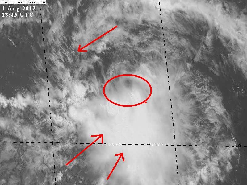
I'm still not seeing much of a surface circulation - not as much as yesterday or the day before. That band to the north is more of an outflow boundary than an inflow feature. And there's a linear band of convection stretching westward along 11N. It remains very poorly organized this morning. Still has a fair potential to become a TD in 24-36 hours, and possibly a weak TS (35-40 kts) prior to reaching the eastern Caribbean.
0 likes

-
'CaneFreak

- Category 5
- Posts: 1487
- Joined: Mon Jun 05, 2006 10:50 am
- Location: New Bern, NC
Re:
I think those images are 12 hours old.  Got ya
On a more serious note, it looks like any ordinary, slowly developing TC that is beginning to consolidate the vorticity a little more and more each and every day.
Got ya On a more serious note, it looks like any ordinary, slowly developing TC that is beginning to consolidate the vorticity a little more and more each and every day.
0 likes
Who is online
Users browsing this forum: No registered users and 91 guests