ATL: ERNESTO - Post-Tropical
Moderator: S2k Moderators

Re: ATL: FIVE - Models
Actually the 18z NOGAPS splits the energy and sends some to Jamaica and the rest out to sea....yep typical NOGAPS....  still the right outlier....as is the CMC....
0 likes
-
znel52
Re: ATL: FIVE - Models
18Z Package....also included is a 18Z CMC run which is new to me....I know the CMC ran regional 18Z packages but not tropical.....anywoo...here you go....
http://www.sfwmd.gov/portal/page/portal ... el%20plots
http://www.sfwmd.gov/portal/page/portal ... el%20plots
0 likes
-
Evil Jeremy

- S2K Supporter

- Posts: 5463
- Age: 32
- Joined: Mon Apr 10, 2006 2:10 pm
- Location: Los Angeles, CA
Re: ATL: FIVE - Tropical Depression
Debby more than filled my seasonal quota for model war watching. This should be a mexico runner, it should remain south enough to slide under whatever ridge gaps pop up. Then again, any unexpected strengthening can draw 5 poleward...
0 likes
Frances 04 / Jeanne 04 / Katrina 05 / Wilma 05 / Fay 08 / Debby 12 / Andrea 13 / Colin 16 / Hermine 16 / Matthew 16 / Irma 17
Re: ATL: FIVE - Models
0 likes
-
tolakram
- Admin

- Posts: 20179
- Age: 62
- Joined: Sun Aug 27, 2006 8:23 pm
- Location: Florence, KY (name is Mark)
Re: ATL: FIVE - Models
Not hard to save and post these ROCK. 

0 likes
M a r k
- - - - -
Join us in chat: Storm2K Chatroom Invite. Android and IOS apps also available.
The posts in this forum are NOT official forecasts and should not be used as such. Posts are NOT endorsed by any professional institution or STORM2K.org. For official information and forecasts, please refer to NHC and NWS products.

-
Blown Away

- S2K Supporter
- Posts: 10253
- Joined: Wed May 26, 2004 6:17 am
Re: ATL: FIVE - Models
Can somebody post what the 18z GFS run did? Can't run it on my phone.
0 likes
Hurricane Eye Experience: David 79, Irene 99, Frances 04, Jeanne 04, Wilma 05… Hurricane Brush Experience: Andrew 92, Erin 95, Floyd 99, Matthew 16, Irma 17, Ian 22, Nicole 22…
Re: ATL: FIVE - Tropical Depression
0 likes
-
tolakram
- Admin
- Posts: 20179
- Age: 62
- Joined: Sun Aug 27, 2006 8:23 pm
- Location: Florence, KY (name is Mark)
Re: ATL: FIVE - Models
ROCK wrote::uarrow: in that map...the NHC follows the TVCN almost exactly. Which is basically a blend of model outputs for a given package.
Not only is it a blend but it is a chosen blend, so they can pick (if I understand it correctly) the models used to produce the track.
http://www.nhc.noaa.gov/modelsummary.shtml
Average of at least 2 of GHMI, EGRI, NGPI, HWFI, GFSI, GFNI, EMXI
I do not know how it works but guessing, they will take the TVCN and make any last minute adjustments to the track based on forecaster knowledge and late conditions to create the NHC track.
Personal Forecast Disclaimer: ^^
The posts in this forum are NOT official forecast and should not be used as such. They are just the opinion of the poster and may or may not be backed by sound meteorological data. They are NOT endorsed by any professional institution or storm2k.org. For official information, please refer to the NHC and NWS products.
0 likes
M a r k
- - - - -
Join us in chat: Storm2K Chatroom Invite. Android and IOS apps also available.
The posts in this forum are NOT official forecasts and should not be used as such. Posts are NOT endorsed by any professional institution or STORM2K.org. For official information and forecasts, please refer to NHC and NWS products.
- - - - -
Join us in chat: Storm2K Chatroom Invite. Android and IOS apps also available.
The posts in this forum are NOT official forecasts and should not be used as such. Posts are NOT endorsed by any professional institution or STORM2K.org. For official information and forecasts, please refer to NHC and NWS products.
-
cycloneye

- Admin
- Posts: 149298
- Age: 69
- Joined: Thu Oct 10, 2002 10:54 am
- Location: San Juan, Puerto Rico
Re: ATL: FIVE - Tropical Depression
Here is this evening's discussion of Tropical Depression Five by Dr Jeff Masters.
Posted by: Dr. Jeff Masters, 6:22 PM AST on August 01, 2012
Tropical Storm Watches are flying for much of the Lesser Antilles, as the islands await the arrival of Tropical Depression Five, which formed at 5 pm EDT today. The new depression is still fairly ragged looking, as seen on visible satellite loops. Heavy thunderstorm activity is only on the south side of the center, due to higher wind shear on the northern side of the storm. Wind shear over TD 5 is at the moderate level, 10 - 15 knots. TD 5 has one respectable low-level spiral band on its south side, but additional spiral bands are beginning to appear, and the areal coverage of the storm's heavy thunderstorms has increased markedly in the late afternoon hours. Water vapor satellite loops show that TD 5 has a reasonably moist environment. Ocean temperatures are 28°C, (82°F) which is about 0.5°C above average for this time of year. The first Air Force hurricane hunter aircraft will investigate TD 5 Thursday afternoon to give us a better idea of its strength.
Forecast for TD 5
TD 5's west-northwest motion should bring its outer rain bands to Barbados early Friday morning, and high winds and heavy rain will spread over the rest of the Windward Islands by Friday afternoon. Since wind shear will be higher on the storm's north side, I expect the heaviest weather will be on the south side of TD 5, over the Windward Islands. Wind shear is expected to remain moderate, 10 - 15 knots, through Friday, ocean temperatures will remain near 28°C, and mid-level moisture will be a moderate 60 - 70%, according to the 2 pm EDT run of the SHIPS model. This should allow TD to become Tropical Storm Ernesto by Thursday. NHC is giving a 27% chance that TD 5 will become a hurricane by Friday afternoon, when it will be passing through the islands. The reliable computer models are not in good agreement on the future intensity of TD 5. A band of high wind shear of 20 - 40 knots associated with an upper level low lies to the north of TD 5, and our most reliable model, the ECMWF, predicts that this shear will extend down into the islands on Friday and Saturday, and tear TD 5 apart. However, the almost equally reliable GFS model predicts that this band of wind shear will remain north of TD 5, and the storm will have clear sailing for the next five days, with only moderate shear of 10 - 15 knots affecting it. At this point, we'll have to wait and see how future model runs handle the shear forecast.
0 likes
Visit the Caribbean-Central America Weather Thread where you can find at first post web cams,radars
and observations from Caribbean basin members Click Here
and observations from Caribbean basin members Click Here
Re: ATL: FIVE - Models
Blown Away wrote:Can somebody post what the 18z GFS run did? Can't run it on my phone.
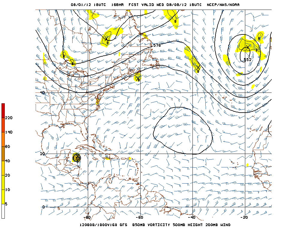
168hrs moving slowly w/wnw.
0 likes
-
Kingarabian

- S2K Supporter
- Posts: 16350
- Joined: Sat Aug 08, 2009 3:06 am
- Location: Honolulu, Hawaii

-
Gustywind

- Category 5

- Posts: 12334
- Joined: Mon Sep 03, 2007 7:29 am
- Location: Baie-Mahault, GUADELOUPE
Atlantic system becomes a tropical depression
Stu Ostro, Senior Meteorologist, The Weather Channel
Aug 1, 2012 5:49 pm ET
 http://www.weather.com/newscenter/tropical/
TROPICAL DEPRESSION FIVE
- The disturbance in the tropical Atlantic passed the "Will it still be maintaining its convection, organization, and spin in the morning?" test, and while there is no aircraft recon, new ASCAT/OSCAT satellite information, or close surface observations, during the day today visible satellite loops suggested that the system and its convection continued to become more focused about a low-mid level, and increasingly a surface, center. Thus it has been officially upgraded to tropical depression status. There's a high probability of further development of this system into Tropical Storm Ernesto.
- The timeline is for it to arrive on Friday in the Lesser Antilles with heavy rain and gusty winds; exactly how much wind will depend on the nature and strength of the system at that point. Then it'll move between W and WNW across the eastern and central Caribbean this weekend, likely to a longitude abeam of Jamaica by Monday. Where it goes from there during the middle and latter part of next week will depend on if the subtropical ridge to the north of it is sufficiently solid and it continues into Mexico or Central America, or if there's enough of a weakness in the ridge to allow for it to take a more northward track in the Gulf of Mexico.
Stu Ostro, Senior Meteorologist, The Weather Channel
Aug 1, 2012 5:49 pm ET
TROPICAL DEPRESSION FIVE
- The disturbance in the tropical Atlantic passed the "Will it still be maintaining its convection, organization, and spin in the morning?" test, and while there is no aircraft recon, new ASCAT/OSCAT satellite information, or close surface observations, during the day today visible satellite loops suggested that the system and its convection continued to become more focused about a low-mid level, and increasingly a surface, center. Thus it has been officially upgraded to tropical depression status. There's a high probability of further development of this system into Tropical Storm Ernesto.
- The timeline is for it to arrive on Friday in the Lesser Antilles with heavy rain and gusty winds; exactly how much wind will depend on the nature and strength of the system at that point. Then it'll move between W and WNW across the eastern and central Caribbean this weekend, likely to a longitude abeam of Jamaica by Monday. Where it goes from there during the middle and latter part of next week will depend on if the subtropical ridge to the north of it is sufficiently solid and it continues into Mexico or Central America, or if there's enough of a weakness in the ridge to allow for it to take a more northward track in the Gulf of Mexico.
0 likes
-
Kingarabian
- S2K Supporter
- Posts: 16350
- Joined: Sat Aug 08, 2009 3:06 am
- Location: Honolulu, Hawaii

-
cycloneye
- Admin
- Posts: 149298
- Age: 69
- Joined: Thu Oct 10, 2002 10:54 am
- Location: San Juan, Puerto Rico
Re: ATL: FIVE - Models
The models should have a better imput of data now that is a TC starting with the 00z package.
0 likes
Visit the Caribbean-Central America Weather Thread where you can find at first post web cams,radars
and observations from Caribbean basin members Click Here
and observations from Caribbean basin members Click Here
Re: ATL: FIVE - Models
I just think it will be interesting to see which model will be correct about the shear. Then to see which one is correct about the possible weakness in the ridge over the central GOM during the middle of next week.
0 likes
Personal Forecast Disclaimer:
The posts in this forum are NOT official forecast and should not be used as such. They are just the opinion of the poster and may or may not be backed by sound meteorological data. They are NOT endorsed by any professional institution or storm2k.org. For official information, please refer to the NHC and NWS products.
The posts in this forum are NOT official forecast and should not be used as such. They are just the opinion of the poster and may or may not be backed by sound meteorological data. They are NOT endorsed by any professional institution or storm2k.org. For official information, please refer to the NHC and NWS products.
Re: ATL: FIVE - Models
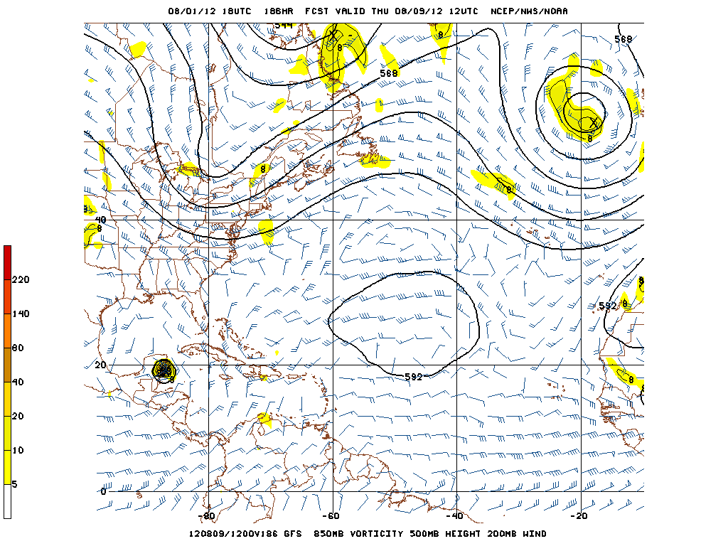
interesting the 18Z GFS plows it into the Yuc and BOC where it dies....Similar to the EURO run sort of...but stronger.
0 likes
Who is online
Users browsing this forum: No registered users and 121 guests