Dave wrote:cycloneye wrote:Dave,departing from St Croix.
Uh no still on runway...instruments are powering up though if you look at the two hdobs so far.
And in the air...enroute now.
Moderator: S2k Moderators


Dave wrote:cycloneye wrote:Dave,departing from St Croix.
Uh no still on runway...instruments are powering up though if you look at the two hdobs so far.


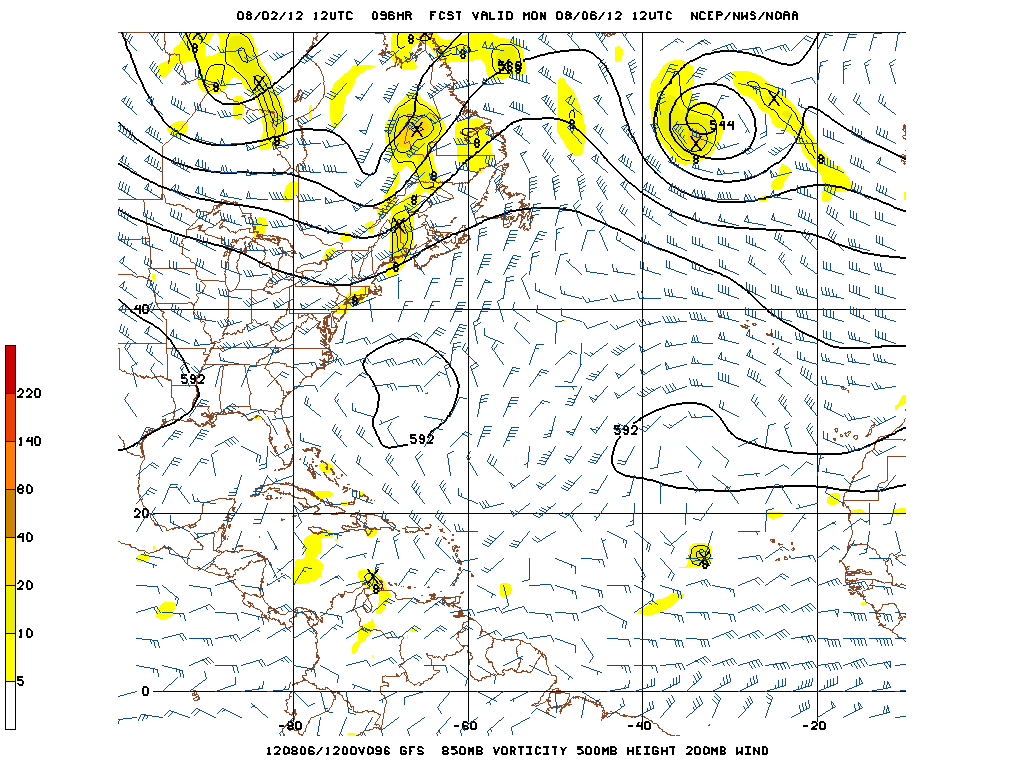
Blown Away wrote:06z GFS, pretty significant swing to the north with landfall near TX/LA border. IMO, under 200 hours is the point where the GFS will start getting a general idea long range with regards to the strength of ridge. If the future GFS runs continue creeping right along the N Gulf coast then maybe there will be a breakdown of the ridge. Looking at the loop, TD5 does not look like it's moving 21 mph, maybe the building convection gives it the appearance of slowing down??
06z GFS at 204 hours:


ozonepete wrote:Riptide wrote:It appears that TD5 is not producing strong convection but developing a good circulation pattern.
http://img228.imageshack.us/img228/1208/visltd5edit.jpg
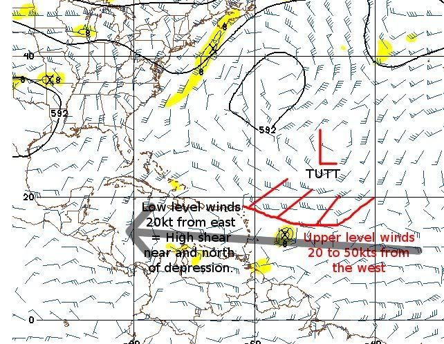
Agreed, except that area you labeled outflow is actually low-level cloud bands moving in towards the center. The outflow is the thinner cirrus clouds at upper levels; that's what's lacking on the north side right now due to some shear.


djmikey wrote:Can you guys explain the pics instead of just the hours for the ones of us that are at work and pics are filtered? It would really help. Im sure I'm not the only one! Thanks!

meteortheologist wrote:ozonepete wrote:Riptide wrote:It appears that TD5 is not producing strong convection but developing a good circulation pattern.
http://img228.imageshack.us/img228/1208/visltd5edit.jpg
Agreed, except that area you labeled outflow is actually low-level cloud bands moving in towards the center. The outflow is the thinner cirrus clouds at upper levels; that's what's lacking on the north side right now due to some shear.
how does this shear affect likelihood of it being a mexican system or heading north towards texas coast?
barometerJane61 wrote:Blown Away wrote:06z GFS, pretty significant swing to the north with landfall near TX/LA border. IMO, under 200 hours is the point where the GFS will start getting a general idea long range with regards to the strength of ridge. If the future GFS runs continue creeping right along the N Gulf coast then maybe there will be a breakdown of the ridge. Looking at the loop, TD5 does not look like it's moving 21 mph, maybe the building convection gives it the appearance of slowing down??
06z GFS at 204 hours:
Any rain out of this for Texas,especially the Northern portion of the state would be welcome.We've been sweltering under temps over the century mark for 7 or 8 straight days now.No relief in sight
meteortheologist wrote:ozonepete wrote:Riptide wrote:It appears that TD5 is not producing strong convection but developing a good circulation pattern.
http://img228.imageshack.us/img228/1208/visltd5edit.jpg
Agreed, except that area you labeled outflow is actually low-level cloud bands moving in towards the center. The outflow is the thinner cirrus clouds at upper levels; that's what's lacking on the north side right now due to some shear.
how does this shear affect likelihood of it being a mexican system or heading north towards texas coast?

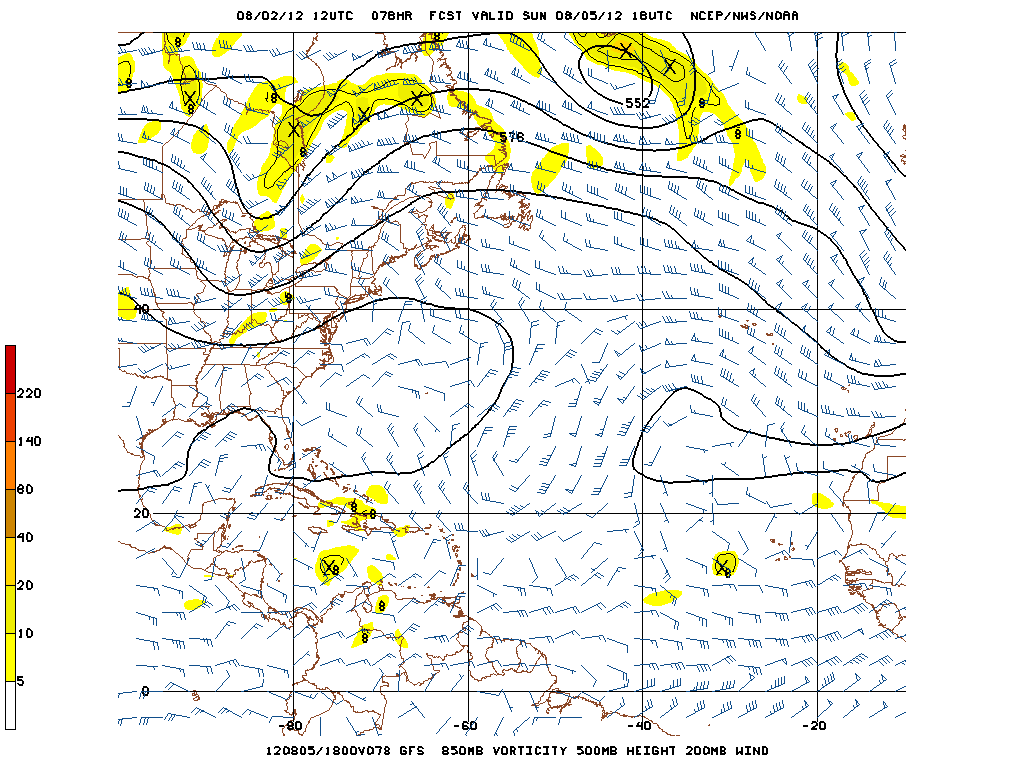
wxman57 wrote:The upper low to its north is "enhancing" the outflow on that side just a little TOO much, but that should be changing as the depression approaches the islands. Wind shear looks to be relatively light once it's in the Caribbean, which should allow for slow strengthening. I don't expect much impact on the islands. Could be a small area of TS winds on the north side, probably staying south of Guadeloupe, Gusty.
It could very well be a hurricane in the NW Caribbean next Tue/Wed and into the southern Gulf by late next Wed or early Thu. Won't venture any guess beyond then, as the models probably don't have the flow right that far out. Much will depend on how much the ridge to its north weakens early next week. Won't rule out an eventual impact anywhere at this time - from southern MX to the FL Panhandle. I think the FL Peninsula is probably not going to be impacted, as that ridge to the north should hold through Monday, regardless of how strong the storm becomes. (not saying the FL peninsula is 100% out of the woods yet, though).


Users browsing this forum: No registered users and 70 guests


