
ATL: ERNESTO - Post-Tropical
Moderator: S2k Moderators
-
TreasureIslandFLGal

- S2K Supporter

- Posts: 1584
- Age: 58
- Joined: Sun Aug 15, 2004 6:16 pm
- Location: Cancun, Mexico (northeast Yucatan coast)
Re: Re:
Sambucol wrote:TreasureIslandFLGal wrote:I have a theory, explained above in greater detail, and of course the disclaimer applies:
1. weak storm that never gets its act together much, puts a tropical storm at the most into the southern Yucatan/Mexico.
2. If it does get its act together though, then Ernesto ends up a hurricane 2/3 into Northern Texas.
When you say northern Texas, do you mean the upper Texas coast?
yup
0 likes
Chrissy & Ligeia


-
Rgv20

- S2K Supporter
- Posts: 2466
- Age: 39
- Joined: Wed Jan 05, 2011 5:42 pm
- Location: Edinburg/McAllen Tx
Well if the 12zGFS were to verify, my area will get some interesting weather next weekend...TD5 makes landfall near Brownsville around next Saturday.
0 likes
The following post is NOT an official forecast and should not be used as such. It is just the opinion of the poster and may or may not be backed by sound meteorological data. It is NOT endorsed by any professional institution including storm2k.org For Official Information please refer to the NHC and NWS products.
-
Blown Away

- S2K Supporter
- Posts: 10253
- Joined: Wed May 26, 2004 6:17 am
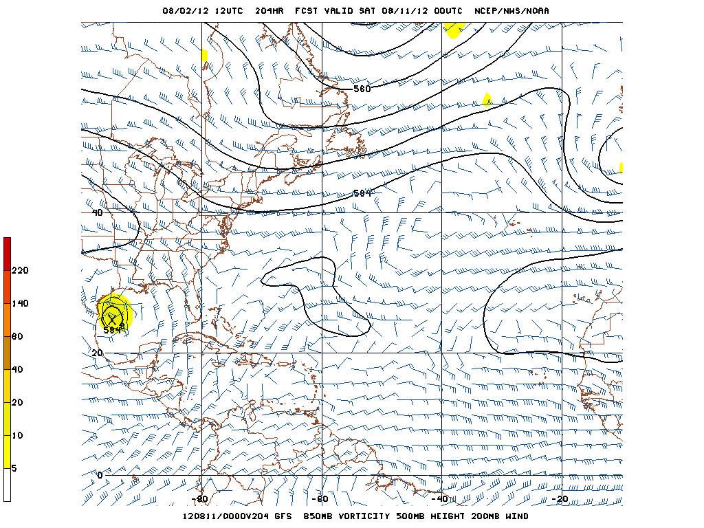
Re: ATL: FIVE - Models

12z GFS, landfall US/Mexico border.
0 likes
Hurricane Eye Experience: David 79, Irene 99, Frances 04, Jeanne 04, Wilma 05… Hurricane Brush Experience: Andrew 92, Erin 95, Floyd 99, Matthew 16, Irma 17, Ian 22, Nicole 22…
-
Dave

- Retired Staff

- Posts: 13442
- Age: 75
- Joined: Tue Aug 01, 2006 3:57 pm
- Location: Milan Indiana
- Contact:
000
URNT15 KNHC 021635
AF302 0105A CYCLONE HDOB 08 20120802
162700 1614N 06134W 4122 07372 0400 -135 -211 086015 017 /// /// 03
162730 1613N 06132W 4128 07358 0400 -136 -211 079012 014 /// /// 03
162800 1612N 06129W 4131 07350 0398 -135 -211 079013 014 /// /// 03
162830 1611N 06127W 4103 07402 0400 -135 -212 080017 017 /// /// 03
162900 1610N 06124W 4098 07415 0401 -137 -213 081018 018 /// /// 03
162930 1608N 06122W 4098 07411 0401 -137 -214 080019 020 /// /// 03
163000 1607N 06120W 4100 07408 0400 -136 -215 080018 019 /// /// 03
163030 1606N 06117W 4098 07411 0400 -135 -216 079018 019 /// /// 03
163100 1605N 06115W 4099 07411 0400 -136 -217 080017 017 019 000 00
163130 1604N 06112W 4099 07410 0401 -138 -217 077019 019 019 000 03
163200 1603N 06110W 4098 07411 0401 -138 -218 081018 019 019 000 00
163230 1602N 06107W 4099 07410 0400 -136 -218 078019 020 022 000 00
163300 1600N 06105W 4099 07410 0399 -135 -219 079018 018 021 000 03
163330 1559N 06103W 4099 07410 0400 -136 -219 078019 020 020 000 00
163400 1558N 06100W 4099 07408 0400 -135 -220 080018 019 020 000 00
163430 1557N 06058W 4098 07411 0400 -136 -220 081019 020 019 000 00
163500 1556N 06055W 4101 07407 0399 -135 -221 079018 019 019 000 00
163530 1555N 06053W 4098 07410 0398 -135 -221 082019 019 020 000 00
163600 1553N 06050W 4098 07408 0398 -135 -221 080020 020 024 000 00
163630 1552N 06048W 4098 07408 0397 -135 -221 083019 020 019 000 00
$$
;
0 likes
-
tolakram
- Admin

- Posts: 20169
- Age: 62
- Joined: Sun Aug 27, 2006 8:23 pm
- Location: Florence, KY (name is Mark)
Re: ATL: FIVE - Tropical Depression
Latest

live visible loop: http://wwwghcc.msfc.nasa.gov/cgi-bin/ge ... umframes=5
longer live loop, no map, speed up for full effect: http://wwwghcc.msfc.nasa.gov/cgi-bin/ge ... 2&map=none
live visible loop: http://wwwghcc.msfc.nasa.gov/cgi-bin/ge ... umframes=5
longer live loop, no map, speed up for full effect: http://wwwghcc.msfc.nasa.gov/cgi-bin/ge ... 2&map=none
0 likes
M a r k
- - - - -
Join us in chat: Storm2K Chatroom Invite. Android and IOS apps also available.
The posts in this forum are NOT official forecasts and should not be used as such. Posts are NOT endorsed by any professional institution or STORM2K.org. For official information and forecasts, please refer to NHC and NWS products.


Re: Re:
TreasureIslandFLGal wrote:Sambucol wrote:TreasureIslandFLGal wrote:I have a theory, explained above in greater detail, and of course the disclaimer applies:
1. weak storm that never gets its act together much, puts a tropical storm at the most into the southern Yucatan/Mexico.
2. If it does get its act together though, then Ernesto ends up a hurricane 2/3 into Northern Texas.
When you say northern Texas, do you mean the upper Texas coast?
yup
Thanks! I'm on the upper Texas coast.
0 likes
-
Dave
- Retired Staff
- Posts: 13442
- Age: 75
- Joined: Tue Aug 01, 2006 3:57 pm
- Location: Milan Indiana
- Contact:
000
URNT15 KNHC 021647
AF302 0105A CYCLONE HDOB 09 20120802
163700 1551N 06046W 4098 07407 0396 -135 -222 083019 020 020 000 00
163730 1550N 06043W 4099 07407 0397 -135 -222 083020 020 020 000 00
163800 1549N 06041W 4099 07407 0396 -135 -222 087020 020 020 000 00
163830 1548N 06038W 4098 07406 0395 -135 -223 086020 021 020 000 00
163900 1546N 06036W 4101 07402 0395 -135 -224 087020 021 020 000 00
163930 1545N 06034W 4098 07406 0394 -135 -224 085021 021 020 000 00
164000 1544N 06031W 4099 07401 0392 -135 -225 084021 021 019 000 00
164030 1543N 06029W 4099 07402 0392 -135 -225 084020 020 019 000 00
164100 1542N 06026W 4099 07401 0391 -135 -226 086019 019 020 000 00
164130 1541N 06024W 4099 07401 0391 -135 -227 085019 020 020 000 00
164200 1540N 06022W 4099 07400 0389 -135 -243 087019 019 019 000 00
164230 1538N 06019W 4098 07397 0387 -135 -269 092018 019 020 000 00
164300 1537N 06017W 4098 07395 0384 -135 -273 091019 019 022 000 00
164330 1536N 06014W 4099 07394 0384 -135 -274 094018 019 020 000 03
164400 1535N 06012W 4099 07394 0386 -133 -276 093019 019 019 000 03
164430 1534N 06010W 4098 07393 0382 -135 -280 094019 019 020 000 03
164500 1533N 06007W 4099 07392 0385 -133 -274 095018 019 020 000 00
164530 1531N 06005W 4097 07412 0398 -125 -244 089020 020 020 000 00
164600 1530N 06002W 4097 07412 0397 -125 -220 093020 020 020 000 00
164630 1529N 06000W 4098 07408 0396 -125 -217 098020 020 020 000 00
$$
;
0 likes
-
SouthDadeFish

- Professional-Met

- Posts: 2835
- Joined: Thu Sep 23, 2010 2:54 pm
- Location: Miami, FL
- Contact:


Re: ATL: FIVE - Tropical Depression
always looks better during the day....improving in appearance....will have to see if it can improve upon it, lower its pressure and make a run at a name today before nightfall.....
0 likes
-
Dave
- Retired Staff
- Posts: 13442
- Age: 75
- Joined: Tue Aug 01, 2006 3:57 pm
- Location: Milan Indiana
- Contact:
000
URNT15 KNHC 021656
AF302 0105A CYCLONE HDOB 10 20120802
164700 1528N 05958W 4098 07408 0395 -125 -220 097020 020 020 000 03
164730 1527N 05955W 4098 07408 0395 -125 -219 097019 020 020 000 00
164800 1526N 05953W 4098 07408 0396 -125 -216 097019 019 020 000 03
164830 1524N 05950W 4098 07408 0392 -127 -214 094018 018 021 000 03
164900 1523N 05948W 4098 07408 0396 -125 -214 090019 019 021 000 00
164930 1522N 05946W 4098 07409 0396 -125 -214 086019 020 020 000 00
165000 1521N 05943W 4098 07407 0395 -121 -213 081020 020 021 000 00
165030 1520N 05941W 4097 07409 0395 -120 -213 081020 020 021 000 00
165100 1519N 05938W 4098 07407 0395 -120 -212 082020 020 021 000 00
165130 1517N 05936W 4098 07408 0396 -120 -212 084019 019 021 000 00
165200 1516N 05934W 4098 07407 0396 -120 -211 082019 020 021 000 00
165230 1515N 05931W 4097 07411 0396 -120 -211 082019 019 022 000 00
165300 1514N 05929W 4098 07408 0396 -117 -210 081018 018 021 000 00
165330 1513N 05926W 4097 07409 0396 -116 -210 079018 018 022 000 03
165400 1512N 05924W 4098 07409 0396 -115 -210 075017 017 021 000 03
165430 1510N 05922W 4098 07409 0397 -115 -209 071017 017 021 000 00
165500 1509N 05919W 4098 07411 0398 -115 -209 071017 017 020 000 03
165530 1508N 05917W 4097 07413 0399 -115 -209 070017 018 019 000 00
165600 1507N 05914W 4097 07413 0399 -115 -209 069016 017 020 000 00
165630 1506N 05912W 4098 07410 0399 -115 -208 070016 016 019 000 00
$$
;
0 likes

Re: ATL: FIVE - Tropical Depression
wxman57 wrote:The upper low to its north is "enhancing" the outflow on that side just a little TOO much, but that should be changing as the depression approaches the islands. Wind shear looks to be relatively light once it's in the Caribbean, which should allow for slow strengthening. I don't expect much impact on the islands. Could be a small area of TS winds on the north side, probably staying south of Guadeloupe, Gusty.
It could very well be a hurricane in the NW Caribbean next Tue/Wed and into the southern Gulf by late next Wed or early Thu. Won't venture any guess beyond then, as the models probably don't have the flow right that far out. Much will depend on how much the ridge to its north weakens early next week. Won't rule out an eventual impact anywhere at this time - from southern MX to the FL Panhandle. I think the FL Peninsula is probably not going to be impacted, as that ridge to the north should hold through Monday, regardless of how strong the storm becomes. (not saying the FL peninsula is 100% out of the woods yet, though).
Excellent write up, Couldn't agree with you more.
0 likes
Re: ATL: FIVE - Models
what a difference between runs...06Z into LA and 12Z into STX.....um thats only like 600 miles lol.....EURO out shortly...
GFDL 12Z should be out soon also. Noticed that model didnt lose the system like before.
Also noticed the 12Z CMC is trending south every run since yesterday. CMC and NOGAPS really your only right outlier...
GFDL 12Z should be out soon also. Noticed that model didnt lose the system like before.
Also noticed the 12Z CMC is trending south every run since yesterday. CMC and NOGAPS really your only right outlier...
0 likes
-
Dave
- Retired Staff
- Posts: 13442
- Age: 75
- Joined: Tue Aug 01, 2006 3:57 pm
- Location: Milan Indiana
- Contact:
This was dropped approaching the islands....
000
UZNT13 KNHC 021634
XXAA 52165 99167 70626 04362 99016 28044 05017 00141 26841 05518
92826 21433 06522 85556 18859 06522 70202 10673 07015 50590 07172
06016 88999 77999
31313 09608 81613
51515 10190 40762
61616 AF302 0105A CYCLONE OB 03
62626 SPL 1672N06269W 1623 MBL WND 05519 AEV 20802 DLM WND 07018
015410 WL150 05518 083 REL 1674N06264W 161343 SPG 1672N06269W 162
332 =
XXBB 52168 99167 70626 04362 00016 28044 11906 20017 22876 18423
33850 18859 44834 19268 55772 16472 66753 14865 77685 09073 88588
00763 99567 01578 11486 08569 22456 08391 33425 10374 44410 14166
21212 00016 05017 11884 07521 22850 06522 33774 08022 44747 06524
55716 08017 66618 06020 77573 10017 88549 07521 99527 08017 11507
05516 22463 05516 33447 03012 44430 08512 55410 10016
31313 09608 81613
51515 10190 40762
61616 AF302 0105A CYCLONE OB 03
62626 SPL 1672N06269W 1623 MBL WND 05519 AEV 20802 DLM WND 07018
015410 WL150 05518 083 REL 1674N06264W 161343 SPG 1672N06269W 162
332 =
;
0 likes
-
Dave
- Retired Staff
- Posts: 13442
- Age: 75
- Joined: Tue Aug 01, 2006 3:57 pm
- Location: Milan Indiana
- Contact:
000
URNT15 KNHC 021705
AF302 0105A CYCLONE HDOB 11 20120802
165700 1504N 05910W 4098 07412 0399 -115 -208 067016 017 019 000 00
165730 1503N 05907W 4098 07412 0399 -115 -207 063016 016 019 000 00
165800 1502N 05905W 4098 07412 0399 -115 -206 062017 017 019 000 03
165830 1501N 05902W 4099 07409 0399 -115 -205 062017 017 019 000 03
165900 1500N 05900W 4097 07413 0400 -115 -207 063017 017 018 000 03
165930 1459N 05858W 4098 07413 0400 -115 -208 063016 017 019 000 00
170000 1457N 05855W 4098 07412 0400 -120 -206 058017 018 019 000 03
170030 1456N 05853W 4099 07409 0399 -120 -206 057018 018 019 000 03
170100 1455N 05850W 4098 07413 0400 -120 -206 058018 018 019 000 00
170130 1454N 05848W 4098 07412 0400 -121 -206 060018 018 020 000 03
170200 1453N 05845W 4098 07410 0399 -120 -206 056018 018 019 000 00
170230 1451N 05843W 4098 07413 0400 -120 -207 053017 018 020 000 03
170300 1450N 05841W 4098 07412 0399 -120 -208 056017 018 020 000 03
170330 1449N 05838W 4098 07413 0400 -120 -208 053018 018 020 000 03
170400 1448N 05836W 4098 07412 0399 -120 -208 050018 018 019 000 03
170430 1447N 05833W 4098 07412 0399 -120 -208 052017 018 019 000 03
170500 1445N 05831W 4097 07413 0399 -120 -208 055018 018 020 000 03
170530 1444N 05828W 4098 07412 0399 -120 -208 055017 018 019 000 00
170600 1443N 05826W 4098 07412 0399 -121 -208 060017 017 019 000 00
170630 1442N 05823W 4098 07413 0400 -120 -209 055018 018 019 000 00
$$
;
0 likes
-
Stormlover2012
- Category 1

- Posts: 262
- Joined: Sat Jun 23, 2012 11:03 am
Re: ATL: FIVE - Models
9 days out my peeps still a long ways to go, just by looking at model runs it looks like the system will feel this weakness but how much!! its going to get interesting thats for sure, but the models will keep jumping back and forth just need to look at consistency and that is euro and gfs has it at the yucatan thats real consistent but after that its game on
0 likes

Re: ATL: FIVE - Models
12Z NOGAPS..I stand corrected...even the NOGAPS has this GOM bound and looks like LA...weak system though...
https://www.fnmoc.navy.mil/wxmap_cgi/cg ... t=Tropical
https://www.fnmoc.navy.mil/wxmap_cgi/cg ... t=Tropical
0 likes
Who is online
Users browsing this forum: No registered users and 9 guests