BEGIN
NHC_ATCF
invest_al912012.invest
FSTDA
R
U
040
010
0000
201208031635
NONE
NOTIFY=ATRP
END
INVEST, AL, L, , , , , 91, 2012, DB, O, 2012080312, 9999999999, , , , , , METWATCH, , AL912012
AL, 91, 2012080218, , BEST, 0, 220N, 765W, 20, 1013, DB, 0, , 0, 0, 0, 0,
AL, 91, 2012080300, , BEST, 0, 226N, 771W, 20, 1013, DB, 0, , 0, 0, 0, 0,
AL, 91, 2012080306, , BEST, 0, 233N, 778W, 20, 1013, DB, 0, , 0, 0, 0, 0,
AL, 91, 2012080312, , BEST, 0, 240N, 785W, 20, 1013, DB, 34, NEQ, 0, 0, 0, 0, 1015, 150, 90, 0, 0, L, 0, , 0, 0, INVEST, S,
Edit: First TWO by NHC:
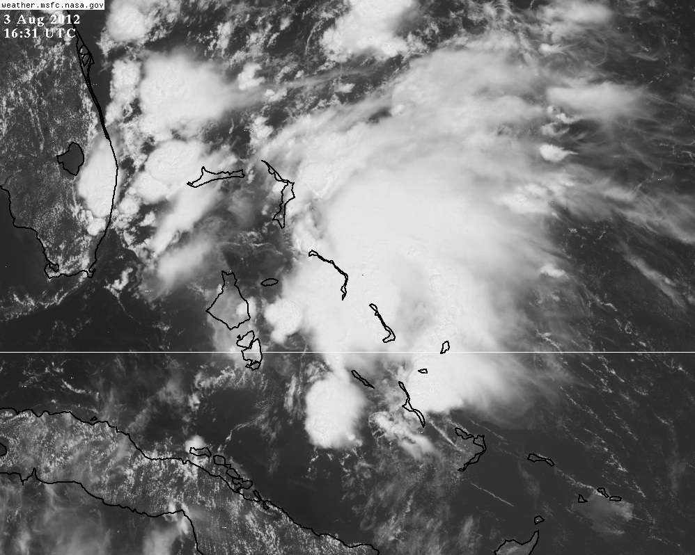
2. DISORGANIZED CLOUDINESS AND SHOWERS OVER THE CENTRAL AND
NORTHWESTERN BAHAMAS AND ADJACENT WESTERN ATLANTIC WATERS ARE
ASSOCIATED WITH A SURFACE TROUGH. STRONG UPPER-LEVEL WINDS ARE
LIKELY TO PREVENT ANY SIGNIFICANT DEVELOPMENT FOR THE NEXT DAY OR
TWO. THIS SYSTEM HAS A LOW CHANCE...10 PERCENT...OF BECOMING A
TROPICAL CYCLONE DURING THE NEXT 48 HOURS AS IT MOVES TO THE
NORTHWEST AT 5 TO 10 MPH.
and the link to the previous thread:
viewtopic.php?f=31&t=113220
ATL: INVEST 91L
Moderator: S2k Moderators
-
Extratropical94

- Professional-Met

- Posts: 3545
- Age: 31
- Joined: Wed Oct 20, 2010 6:36 am
- Location: Hamburg, Germany
- Contact:
ATL: INVEST 91L
Last edited by Extratropical94 on Fri Aug 03, 2012 11:53 am, edited 1 time in total.
0 likes
54° 11' 59'' N, 9° 9' 20'' E
Boomer Sooner!
Go Broncos! Go Cards!
Clinching counties, one at a time: https://mob-rule.com/user-gifs/USA/xtrp94.gif
- Daniel
Boomer Sooner!
Go Broncos! Go Cards!
Clinching counties, one at a time: https://mob-rule.com/user-gifs/USA/xtrp94.gif
- Daniel

-
tolakram
- Admin

- Posts: 20189
- Age: 62
- Joined: Sun Aug 27, 2006 8:23 pm
- Location: Florence, KY (name is Mark)
Re: ATL: INVEST 91L
0 likes
M a r k
- - - - -
Join us in chat: Storm2K Chatroom Invite. Android and IOS apps also available.
The posts in this forum are NOT official forecasts and should not be used as such. Posts are NOT endorsed by any professional institution or STORM2K.org. For official information and forecasts, please refer to NHC and NWS products.
-
Blown Away

- S2K Supporter

- Posts: 10253
- Joined: Wed May 26, 2004 6:17 am
Re: ATL: INVEST 91L
Wouldn't be surprised if we get a weak TS out of this area before crossing Florida, just my prediction. 
0 likes
Hurricane Eye Experience: David 79, Irene 99, Frances 04, Jeanne 04, Wilma 05… Hurricane Brush Experience: Andrew 92, Erin 95, Floyd 99, Matthew 16, Irma 17, Ian 22, Nicole 22…
-
TropicalAnalystwx13

- Category 5

- Posts: 2109
- Age: 28
- Joined: Tue Jul 19, 2011 8:20 pm
- Location: Wilmington, NC
- Contact:
ATL: INVEST 91L - Recon
000
NOUS42 KNHC 031409
REPRPD
WEATHER RECONNAISSANCE FLIGHTS
CARCAH, NATIONAL HURRICANE CENTER, MIAMI, FL.
1015 AM EDT FRI 03 AUGUST 2012
SUBJECT: TROPICAL CYCLONE PLAN OF THE DAY (TCPOD)
VALID 04/1100Z TO 05/1100Z AUGUST 2012
TCPOD NUMBER.....12-077
I. ATLANTIC REQUIREMENTS
1. TROPICAL STORM ERNESTO
FLIGHT ONE -TEAL 70- FLIGHT TWO -TEAL 71-
A. 04/1200, 1800Z A. 05/0000Z, 0600Z
B. AFXXX 0405A ERNESTO B. AFXXX 0505A ERNESTO
C. 04/1030Z C. 04/2200Z
D. 14.4N 68.1W D. 15.0N 71.2W
E. 04/1130Z TO 04/1800Z E. 04/2330Z TO 05/0600Z
F. SFC TO 10,000 FT F. SFC TO 10,000 FT
2. OUTLOOK FOR SUCCEEDING DAY: CONTINUE 6-HRLY FIXES.
3. REMARKS: BECAUSE OF THE STORM'S LOCATION AND FOR MORE
FAVORABLE CREW SEQUENCING, TODAY'S FIX FOR 03/1800Z
HAS BEEN SLIPPED TO 03/2200Z AND THE 04/0600Z
REQUIREMENT HAS BEEN CANCELED.
4. SUSPECT AREA (OFF EAST COAST OF FLORIDA)
FLIGHT ONE -TEAL 73-
A. 04/1900Z
B. AFXXX 01BBA INVEST
C. 04/1700Z
D. 28.0N 80.0W
E. 04/1830Z TO 04/2130Z
F. SFC TO 10,000 FT
5. SUCCEEDING DAY OUTLOOK.....NEGATIVE.
II. PACIFIC REQUIREMENTS
1. NEGATIVE RECONNAISSANCE REQUIREMENTS.
2. OUTLOOK FOR SUCCEEDING DAY.....NEGATIVE.
$$
JWP
RECON decoding tutorial - viewtopic.php?f=29&t=85603
0 likes
-
DESTRUCTION5

- Category 5
- Posts: 4430
- Age: 44
- Joined: Wed Sep 03, 2003 11:25 am
- Location: Stuart, FL
-
TropicalAnalystwx13
- Category 5
- Posts: 2109
- Age: 28
- Joined: Tue Jul 19, 2011 8:20 pm
- Location: Wilmington, NC
- Contact:
-
SouthFLTropics

- Category 5
- Posts: 4258
- Age: 50
- Joined: Thu Aug 14, 2003 8:04 am
- Location: Port St. Lucie, Florida
Re: ATL: INVEST 91L
Nothing like a little homebrew to keep everyone on their toes...like there isn't enough going on already! I was wondering if this system was going to get tagged...Looked a bit suspicious. Does it have any model support???
SFT
SFT
0 likes
Fourth Generation Florida Native
Personal Storm History: David 79, Andrew 92, Erin 95, Floyd 99, Irene 99, Frances 04, Jeanne 04, Wilma 05, Matthew 16, Irma 17, Ian 22, Nicole 22, Milton 24
Personal Storm History: David 79, Andrew 92, Erin 95, Floyd 99, Irene 99, Frances 04, Jeanne 04, Wilma 05, Matthew 16, Irma 17, Ian 22, Nicole 22, Milton 24
-
AdvAutoBob

- S2K Supporter
- Posts: 85
- Joined: Mon Aug 30, 2004 5:03 pm
- Location: North Ft Myers, FL
- Contact:
Re: ATL: INVEST 91L
Well, this pretty much made my decision for not racing tomorrow... showers are likely going to pop up all over southern Florida, even if this doesn't strengthen into a TD/TS.
Seems like it's gotten busy all of a sudden, especially after the quietest July that I can remember.
Seems like it's gotten busy all of a sudden, especially after the quietest July that I can remember.
0 likes

Re: ATL: INVEST 91L
Are the So Fla mets saying anything about this one? I have a friend in that vicinity leaving on vacation tomorrow who wonders if he should make any preps to his house before leaving. Any ideas? 
0 likes
-
ObsessedMiami

- Category 1

- Posts: 432
- Joined: Tue Aug 31, 2004 8:08 pm
- Location: West Kendall, Fl
-
adam0983
Re: ATL: INVEST 91L
I have a cruise out of Miami Tommarow should I be worried. Does anyone know where in Florida this might make landfall in?
0 likes
-
Blown Away
- S2K Supporter
- Posts: 10253
- Joined: Wed May 26, 2004 6:17 am
Re: ATL: INVEST 91L
adam0983 wrote:I have a cruise out of Miami Tommarow should I be worried. Does anyone know where in Florida this might make landfall in?
Well likely not a landfall point, just a big mess moving NW towards E Central Florida tonight/tomorrow. Center is near Andros island now and will be north of you by tomorrow. If the cruise is going south you should be ok from 91L but will have to watch out for Ernie! JMHO
0 likes
Hurricane Eye Experience: David 79, Irene 99, Frances 04, Jeanne 04, Wilma 05… Hurricane Brush Experience: Andrew 92, Erin 95, Floyd 99, Matthew 16, Irma 17, Ian 22, Nicole 22…
-
Bocadude85

- Category 5
- Posts: 2991
- Age: 39
- Joined: Mon Apr 18, 2005 2:20 pm
- Location: Honolulu,Hi
Re: ATL: INVEST 91L
adam0983 wrote:I have a cruise out of Miami Tommarow should I be worried. Does anyone know where in Florida this might make landfall in?
Unless this develops rapidly you have nothing to worry about
0 likes
-
AdvAutoBob
- S2K Supporter
- Posts: 85
- Joined: Mon Aug 30, 2004 5:03 pm
- Location: North Ft Myers, FL
- Contact:
Re: ATL: INVEST 91L
10% chance of development according to NHC.. I wouldn't get too wound up just yet.
Personal Forecast Disclaimer:
The posts in this forum are NOT official forecast and should not be used as such. They are just the opinion of the poster and may or may not be backed by sound meteorological data. They are NOT endorsed by any professional institution or storm2k.org. For official information, please refer to the NHC and NWS products.
0 likes
-
tolakram
- Admin
- Posts: 20189
- Age: 62
- Joined: Sun Aug 27, 2006 8:23 pm
- Location: Florence, KY (name is Mark)
Re: ATL: INVEST 91L
Up to 20%
A LARGE AREA OF DISORGANIZED SHOWERS AND THUNDERSTORMS OVER THE
CENTRAL AND NORTHWESTERN BAHAMAS AND ADJACENT WESTERN ATLANTIC
WATERS IS ASSOCIATED WITH A SURFACE TROUGH. UPPER-LEVEL WINDS
COULD BECOME A LITTLE MORE CONDUCIVE FOR DEVELOPMENT OVER THE
WEEKEND AS THE TROUGH MOVES TO THE NORTHWEST AT 5 TO 10 MPH. THIS
SYSTEM HAS A LOW CHANCE...20 PERCENT...OF BECOMING A TROPICAL
CYCLONE DURING THE NEXT 48 HOURS.
http://www.nhc.noaa.gov/text/refresh/MI ... 1746.shtml
0 likes
M a r k
- - - - -
Join us in chat: Storm2K Chatroom Invite. Android and IOS apps also available.
The posts in this forum are NOT official forecasts and should not be used as such. Posts are NOT endorsed by any professional institution or STORM2K.org. For official information and forecasts, please refer to NHC and NWS products.
- - - - -
Join us in chat: Storm2K Chatroom Invite. Android and IOS apps also available.
The posts in this forum are NOT official forecasts and should not be used as such. Posts are NOT endorsed by any professional institution or STORM2K.org. For official information and forecasts, please refer to NHC and NWS products.
-
Blown Away
- S2K Supporter
- Posts: 10253
- Joined: Wed May 26, 2004 6:17 am
Re: ATL: INVEST 91L

OMG, I will be in the NE Quadrant of 91L!!
j/k
0 likes
Hurricane Eye Experience: David 79, Irene 99, Frances 04, Jeanne 04, Wilma 05… Hurricane Brush Experience: Andrew 92, Erin 95, Floyd 99, Matthew 16, Irma 17, Ian 22, Nicole 22…

Re: ATL: INVEST 91L
0 likes
-
adam0983
Re: ATL: INVEST 91L
Does any one think that a tropical storm warning might be required for parts of florida over the next 3 days? Invest 91L looking great at the moment.
0 likes
Who is online
Users browsing this forum: No registered users and 54 guests