
Those hot towers kicked off some fast cirrus building.
http://www.ssd.noaa.gov/PS/TROP/floater ... -long.html
ATL: INVEST 91L
Moderator: S2k Moderators

It sucks that I will feel the effects of 91L while I vacation down here in South Beach. I was talking to some of the tourists telling them that a tropical disturbance was forming near the Bahamas and they were looking at me like I was nuts, it never fails, lol.
This is a view from the beach as one of the squall like squalls moved in, and now is storming bad.
Remember who told you to keep an eye on this tropical wave when it was to move over the Bahamas
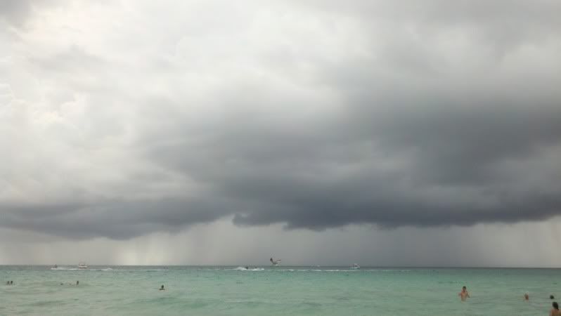
This is a view from the beach as one of the squall like squalls moved in, and now is storming bad.
Remember who told you to keep an eye on this tropical wave when it was to move over the Bahamas
0 likes
-
brunota2003

- S2K Supporter

- Posts: 9476
- Age: 35
- Joined: Sat Jul 30, 2005 9:56 pm
- Location: Stanton, KY...formerly Havelock, NC
- Contact:
Looking at the low level cloud lines into the convection...I can see SW, S, SE, and E winds at the very least. With convection continuing to fire dramatically in the same locations (organized?), only a matter of time before inflow starts being pulled in from the other sectors...and then hello surface low!
0 likes
Just a small town southern boy helping other humans.

Probably not much time for this to develop much to affect South Florida with more than type weather we are getting right now. Quick moving thunderstorms and gusty winds. If it is to intensify we will see done quick clearing as it consolidates. I don't see much more than rainy weather with some quick bursts of heavy rain. Good continuation of drought buster weather we have had here on the east coast of Fl. Southwest Fl. Could really use this rain. We were like 5th wettest July and west coast was like 5th driest!
Personal Forecast Disclaimer:
The posts in this forum are NOT official forecast and should not be used as such. They are just the opinion of the poster and may or may not be backed by sound meteorological data. They are NOT endorsed by any professional institution or storm2k.org. For official information, please refer to the NHC and NWS products.
0 likes
-
Weatherboy1

- Category 5

- Posts: 1190
- Age: 50
- Joined: Mon Jul 05, 2004 1:50 pm
- Location: Jupiter/Sarasota, FL
Re: ATL: INVEST 91L
sunnyday wrote:Are the So Fla mets saying anything about this one? I have a friend in that vicinity leaving on vacation tomorrow who wonders if he should make any preps to his house before leaving. Any ideas?
I don't see any preps needed as the weather should be typical Florida type thunderstorms, nothing to prepare for.
Personal Forecast Disclaimer:
The posts in this forum are NOT official forecast and should not be used as such. They are just the opinion of the poster and may or may not be backed by sound meteorological data. They are NOT endorsed by any professional institution or storm2k.org. For official information, please refer to the NHC and NWS products.
0 likes
-
vbhoutex

- Storm2k Executive

- Posts: 29145
- Age: 74
- Joined: Wed Oct 09, 2002 11:31 pm
- Location: Cypress, TX
- Contact:
Re: ATL: INVEST 91L
Just took my first look at this. Interesting to say the least. It does look like there may be an elongated sw-ne llc trying to form, but it certainly doesn't have time to do much if it is moving W.
0 likes
Skywarn, C.E.R.T.
Please click below to donate to STORM2K to help with the expenses of keeping the site going:

Please click below to donate to STORM2K to help with the expenses of keeping the site going:
-
Blown Away

- S2K Supporter
- Posts: 10253
- Joined: Wed May 26, 2004 6:17 am
Re: ATL: INVEST 91L

http://www.ssd.noaa.gov/PS/TROP/floater ... -long.html
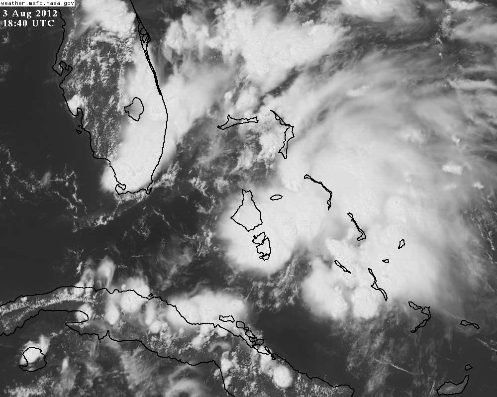
Convection is bombing! It is raining hard here in West Palm Beach.
0 likes
Hurricane Eye Experience: David 79, Irene 99, Frances 04, Jeanne 04, Wilma 05… Hurricane Brush Experience: Andrew 92, Erin 95, Floyd 99, Matthew 16, Irma 17, Ian 22, Nicole 22…
Yeah, not the best UL conditions for 91L to strengthen to other than a weak tropical storm, if that, the UL trough is too close to it giving it a subtropical like set up.
However, if it stays over water longer than thought, UL conditions can become better starting tomorrow and we know how fast tropical systems can strengthen over the gulf stream.
However, if it stays over water longer than thought, UL conditions can become better starting tomorrow and we know how fast tropical systems can strengthen over the gulf stream.
0 likes
-
Florida1118
Re: ATL: INVEST 91L
"UPPER-LEVEL WINDS COULD BECOME A LITTLE MORE CONDUCIVE FOR DEVELOPMENT OVER THE WEEKEND AS THE TROUGH MOVES TO THE NORTHWEST AT 5 TO 10 MPH." -From 2pm TWO
Thats the key though. If conditions in the NE gulf allow, after it passes over FL it may have time to spin up.
Thats the key though. If conditions in the NE gulf allow, after it passes over FL it may have time to spin up.
0 likes
Re:
NDG wrote:Yeah, not the best UL conditions for 91L to strengthen to other than a weak tropical storm, if that, the UL trough is too close to it giving it a subtropical like set up.
However, if it stays over water longer than thought, UL conditions can become better starting tomorrow and we know how fast tropical systems can strengthen over the gulf stream.
Being over water longer also entails a Northward component to movement.
0 likes
Re: ATL: INVEST 91L
May see the development of an anti-cyclone just south of Andros later tonight.
That large cell is firing in low shear.
http://www.nrlmry.navy.mil/nexdat/CONUS ... bean.0.jpg
http://tropic.ssec.wisc.edu/real-time/w ... oom=&time=
That large cell is firing in low shear.
http://www.nrlmry.navy.mil/nexdat/CONUS ... bean.0.jpg
http://tropic.ssec.wisc.edu/real-time/w ... oom=&time=
0 likes
Re: Re:
fci wrote:NDG wrote:Yeah, not the best UL conditions for 91L to strengthen to other than a weak tropical storm, if that, the UL trough is too close to it giving it a subtropical like set up.
However, if it stays over water longer than thought, UL conditions can become better starting tomorrow and we know how fast tropical systems can strengthen over the gulf stream.
Being over water longer also entails a Northward component to movement.
I am not buying the BAM models track, I think it will move northward along SE coast of FL making landfall near Cape Canaveral or just southward, I am not sure if it would make it out to the gulf.
Personal Forecast Disclaimer:
The posts in this forum are NOT official forecast and should not be used as such. They are just the opinion of the poster and may or may not be backed by sound meteorological data. They are NOT endorsed by any professional institution or storm2k.org. For official information, please refer to the NHC and NWS products.
0 likes
-
Houstonia

- S2K Supporter
- Posts: 829
- Age: 61
- Joined: Fri Oct 11, 2002 9:45 am
- Location: Sharpstown, Houston, Harris County, Southeast Texas.
Re: ATL: INVEST 91L
Some of the models show 91 being a possible weather-maker for NoLa and even Texas further down the line (the BAMS in particular). Obviously, as a SETX resident, I'm wondering what you all make of that possibility?
thanks!
thanks!
0 likes
-
tolakram
- Admin
- Posts: 20179
- Age: 62
- Joined: Sun Aug 27, 2006 8:23 pm
- Location: Florence, KY (name is Mark)
Re: ATL: INVEST 91L
Inflow around that blowup starting to look impressive.
live loop: http://wwwghcc.msfc.nasa.gov/cgi-bin/ge ... mframes=10
Speed it up to better show the movement.
Personal Forecast Disclaimer:
The posts in this forum are NOT official forecast and should not be used as such. They are just the opinion of the poster and may or may not be backed by sound meteorological data. They are NOT endorsed by any professional institution or storm2k.org. For official information, please refer to the NHC and NWS products.
0 likes
M a r k
- - - - -
Join us in chat: Storm2K Chatroom Invite. Android and IOS apps also available.
The posts in this forum are NOT official forecasts and should not be used as such. Posts are NOT endorsed by any professional institution or STORM2K.org. For official information and forecasts, please refer to NHC and NWS products.
Nassau's pressure is still relatively high but it continues to lower, down 3 mb from yesterday.
http://w1.weather.gov/data/obhistory/MYNN.html
http://w1.weather.gov/data/obhistory/MYNN.html
0 likes
Re: ATL: INVEST 91L
Getting a really nice infeed of unstable air coming in from SW of Andros.
Its firing off convection on the north shore of Cuba as well.
Seeing LI values down to -9.
http://www.ssd.noaa.gov/PS/TROP/floater ... -long.html
Its firing off convection on the north shore of Cuba as well.
Seeing LI values down to -9.
http://www.ssd.noaa.gov/PS/TROP/floater ... -long.html
0 likes
-
gatorcane

- S2K Supporter
- Posts: 23708
- Age: 48
- Joined: Sun Mar 13, 2005 3:54 pm
- Location: Boca Raton, FL
Certainly looks like this system is trying to organize and I expect the NHC could raise development chances again next adivsory...good thing it won't have much time over water. Shear is dropping and SSTs are very warm.
The NOGAPS model may just have been on to something yesterday when it showed his area spinning up.
How much it can erode the ridge and where it erodes it may impact the future track of Ernesto.
The NOGAPS model may just have been on to something yesterday when it showed his area spinning up.
How much it can erode the ridge and where it erodes it may impact the future track of Ernesto.
0 likes
Re: ATL: INVEST 91L
LLC pegged just NW of Andros
http://rammb.cira.colostate.edu/product ... 031845.jpg
http://rammb.cira.colostate.edu/product ... 1208031800
http://rammb.cira.colostate.edu/product ... 031845.jpg
http://rammb.cira.colostate.edu/product ... 1208031800
0 likes
Who is online
Users browsing this forum: No registered users and 22 guests