
92L is embedded in a low lattitude ridge that is expanding west. There is an ULL centered over Cuba rolling west behind Ernestos anticyclone in the upper air steering element train. The TUTT to the northwest that shredded Florence remnants is sliding southeast but not digging as quickly.
It now looks like 92L will stay south enough that it does not meet Florences fate with the dry air and TUTT.
Ernesto found better conditions west of 50W, maybe in a day or two we will see a depression.
The risk to the islands increases as 92L loses lattitude and stays weak but i'm not sure why we needed a special 70% status change notice last night?
ATL: HELENE - Post-Tropical
Moderator: S2k Moderators
-
Gustywind

- Category 5

- Posts: 12334
- Joined: Mon Sep 03, 2007 7:29 am
- Location: Baie-Mahault, GUADELOUPE
Stu Ostro, Senior Meteorologist, The Weather Channel
Aug 9, 2012 12:22 am ET
 http://www.weather.com/newscenter/tropical/
Graphical tropical update:Tropics Watch
ATLANTIC
- In the eastern Atlantic, a disturbance in the "monsoon trough" has been showing increasing characteristics of a tropical depression, i.e. more organization and concentration of the convection. This system will be near the Lesser Antilles by Saturday.
Aug 9, 2012 12:22 am ET
Graphical tropical update:Tropics Watch
ATLANTIC
- In the eastern Atlantic, a disturbance in the "monsoon trough" has been showing increasing characteristics of a tropical depression, i.e. more organization and concentration of the convection. This system will be near the Lesser Antilles by Saturday.
0 likes
-
Gustywind
- Category 5
- Posts: 12334
- Joined: Mon Sep 03, 2007 7:29 am
- Location: Baie-Mahault, GUADELOUPE
Loop
http://sirocco.accuweather.com/sat_mosaic_640x480_public/ei/isaeatle.gif
*edited by sg to remove hotlinked IMG tags
http://sirocco.accuweather.com/sat_mosaic_640x480_public/ei/isaeatle.gif
*edited by sg to remove hotlinked IMG tags
0 likes
-
ouragans

- Category 2

- Posts: 501
- Age: 54
- Joined: Sun Jun 12, 2011 12:09 pm
- Location: Abymes, Guadeloupe F.W.I
- Contact:
Re:
Gustywind wrote:Waouw after TS Ernesto (who was hopefully weak when crossing), for the Lesser Antilles a possibility to deal with a DT even a TS at the same period Friday/ Saturday?
Two weeks in a row?
The only difference is that this potential TS might be in the Leewards, and Guadeloupe is one of the targets. Last week, we only had peripherical effects, when this time we might have a direct hit by Saturday
0 likes
Personal forecast disclaimer
This post is a personal point of view, not an information. Please refer to official statements for life-threatening decisions.
David '79, Frederic '79, Hugo '89, Iris, Luis & Marilyn '95, Georges '98, Lenny '99, Dean '07, Irma '17, Maria '17, Fiona '22, Philippe '23, Tammy '23
16°13'33.3,"6N -61°36'39.5"W

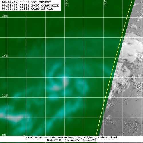
92L looks like its on the northern edge of the convection, with weaker shallow convection over the center itself. I'd say around 13.5-14N at the moment, I do think shear has impacted this system somewhat as well from the north-east.
Good inflow channel from the ITCZ so it should still develop even if upper conditions aren't perfect right now.
Good inflow channel from the ITCZ so it should still develop even if upper conditions aren't perfect right now.
0 likes
Personal Forecast Disclaimer:
The posts in this forum are NOT official forecast and should not be used as such. They are just the opinion of the poster and may or may not be backed by sound meteorological data. They are NOT endorsed by any professional institution or storm2k.org. For official information, please refer to the NHC and NWS products
The posts in this forum are NOT official forecast and should not be used as such. They are just the opinion of the poster and may or may not be backed by sound meteorological data. They are NOT endorsed by any professional institution or storm2k.org. For official information, please refer to the NHC and NWS products

Re: ATL: INVEST 92L
I can't figure the need for the special TWO either. There's no land anywhere near 92L and it's not like it's moving at 30 mph or something that it could strike the Lesser Antilles within a day. Interesting graphic though, with the red and yellow circles switched around. I'm downloading it because one never knows... it could fetch a good price because of it's rarity. (Something like this postage stampfci wrote:cycloneye wrote:Up to 70%
Special Tropical Weather Outlook
THE CIRCULATION ASSOCIATED WITH A SMALL LOW PRESSURE SYSTEM LOCATED
ABOUT 950 MILES WEST OF THE SOUTHERN CAPE VERDE ISLANDS HAS
CONTINUED TO BECOME BETTER DEFINED OVER THE PAST SEVERAL HOURS.
THUNDERSTORM ACTIVITY IS ORGANIZING AROUND THE SURFACE CENTER...AND
UPPER-LEVEL WINDS ARE EXPECTED TO BE CONDUCIVE FOR THE DEVELOPMENT
OF A TROPICAL DEPRESSION OVER THE NEXT COUPLE OF DAYS. THIS SYSTEM
HAS A HIGH CHANCE...70 PERCENT...OF BECOMING A TROPICAL CYCLONE
DURING THE NEXT 48 HOURS AS IT MOVES WESTWARD AT ABOUT 15 MPH.
I'm kind of curious as to why a "Special Tropical Weather Outlook" would be issued.
The % only went from 50 to 70 and it could have been taken care of in the regularly scheduled 2:00 AM outlook.
I would think that a STWO would be issued if they were announcing that advisories were about to be issued, not to just increase the % chance of a tropical cyclone developing in the next 48 hours.
Just curious......
0 likes
-
Gustywind
- Category 5
- Posts: 12334
- Joined: Mon Sep 03, 2007 7:29 am
- Location: Baie-Mahault, GUADELOUPE
Re: Re:
ouragans wrote:Gustywind wrote:Waouw after TS Ernesto (who was hopefully weak when crossing), for the Lesser Antilles a possibility to deal with a DT even a TS at the same period Friday/ Saturday?
The only difference is that this potential TS might be in the Leewards, and Guadeloupe is one of the targets. Last week, we only had peripherical effects, when this time we might have a direct hit by Saturday
I didn't want to say that in my last post ouragans
0 likes
-
Blown Away

- S2K Supporter

- Posts: 10253
- Joined: Wed May 26, 2004 6:17 am
Re: ATL: INVEST 92L

TAFB 72 hour position.

06z Bams/TVCN
0 likes
Hurricane Eye Experience: David 79, Irene 99, Frances 04, Jeanne 04, Wilma 05… Hurricane Brush Experience: Andrew 92, Erin 95, Floyd 99, Matthew 16, Irma 17, Ian 22, Nicole 22…
-
ouragans
- Category 2
- Posts: 501
- Age: 54
- Joined: Sun Jun 12, 2011 12:09 pm
- Location: Abymes, Guadeloupe F.W.I
- Contact:
Re: Re:
Gustywind wrote:I didn't want to say that in my last post ouragans, but as you said that could BE highly possible if 92L continues to organize and heading between 14 N and 17N. Guadeloupe seems today one of these island who could be directly impacedt, but let's wait and see hoping for the best for us
.
if the current trend continues, and we have a track very close to Guadeloupe, the final stage of the Bicycle tour could be cancel as well. That's why I'm very concerned with 92L approach
0 likes
Personal forecast disclaimer
This post is a personal point of view, not an information. Please refer to official statements for life-threatening decisions.
David '79, Frederic '79, Hugo '89, Iris, Luis & Marilyn '95, Georges '98, Lenny '99, Dean '07, Irma '17, Maria '17, Fiona '22, Philippe '23, Tammy '23
16°13'33.3,"6N -61°36'39.5"W
This post is a personal point of view, not an information. Please refer to official statements for life-threatening decisions.
David '79, Frederic '79, Hugo '89, Iris, Luis & Marilyn '95, Georges '98, Lenny '99, Dean '07, Irma '17, Maria '17, Fiona '22, Philippe '23, Tammy '23
16°13'33.3,"6N -61°36'39.5"W

-
Gustywind
- Category 5
- Posts: 12334
- Joined: Mon Sep 03, 2007 7:29 am
- Location: Baie-Mahault, GUADELOUPE
Re: Re:
ouragans wrote:Gustywind wrote:I didn't want to say that in my last post ouragans
if the current trend continues, and we have a track very close to Guadeloupe, the final stage of the Bicycle tour could be cancel as well. That's why I'm very concerned with 92L approach
You're right concerning the Bicycle Tour. If this is confirmed, that could be the first time (given my poor archive) to have a so short edition with at least two runs cancelled
Ouragans, note that our Pro Mets of Meteo-France Guadeloupe in their weather forecast... do not anticipated any strong twave or TD close to our area. So, are they lowering the chances of 92L? or waiting to see more organization?! answer in the next weather forecast at 12AM
0 likes
Re: ATL: INVEST 92L
If it doesn't get shredded it should burst closer to the islands like Ernesto.
0 likes
-
tolakram
- Admin

- Posts: 20185
- Age: 62
- Joined: Sun Aug 27, 2006 8:23 pm
- Location: Florence, KY (name is Mark)
Re: ATL: INVEST 92L
latest loop

0 likes
M a r k
- - - - -
Join us in chat: Storm2K Chatroom Invite. Android and IOS apps also available.
The posts in this forum are NOT official forecasts and should not be used as such. Posts are NOT endorsed by any professional institution or STORM2K.org. For official information and forecasts, please refer to NHC and NWS products.
-
Gustywind
- Category 5
- Posts: 12334
- Joined: Mon Sep 03, 2007 7:29 am
- Location: Baie-Mahault, GUADELOUPE
000
AGXX40 KNHC 090758
MIMATS
MARINE WEATHER DISCUSSION
NWS NATIONAL HURRICANE CENTER MIAMI FL
400 AM EDT THU AUG 9 2012
MARINE WEATHER DISCUSSION FOR THE GULF OF MEXICO...CARIBBEAN SEA
AND TROPICAL N ATLC...AND SOUTHWEST NORTH ATLC S OF 31N W OF 55W.
CARIBBEAN SEA AND TROPICAL N ATLC W OF 55W...
SECOND WELL ORGANIZED TROPICAL WAVE WILL REACH TROPICAL N ATLC
OFFSHORE WATERS SAT AFTERNOON INTO SAT NIGHT AND CURRENTLY HAS A
GOOD CHANCE OF BECOMING A TROPICAL CYCLONE BY THAT TIME. MODELS
HAVE WIDELY VARYING SOLUTIONS WITH THIS FEATURE...WITH GFS MUCH
FASTER AND TO S OF EUROPEAN SOLUTIONS. FORECAST IS BASED ON
SOMEWHAT OF A COMPROMISE OF GFS...ECMWF...AND TCVN.
0 likes
-
cycloneye

- Admin
- Posts: 149481
- Age: 69
- Joined: Thu Oct 10, 2002 10:54 am
- Location: San Juan, Puerto Rico
Re: ATL: INVEST 92L
Stays at 70%
SHOWERS AND THUNDERSTORMS ASSOCIATED WITH A LOW PRESSURE SYSTEM
LOCATED ABOUT 1050 MILES WEST OF THE SOUTHERN CAPE VERDE ISLANDS
CONTINUE TO SHOW LITTLE CHANGE IN ORGANIZATION. UPPER-LEVEL WINDS
APPEAR CONDUCIVE FOR FURTHER DEVELOPMENT AND A TROPICAL DEPRESSION
COULD FORM OVER THE NEXT COUPLE OF DAYS. THIS SYSTEM HAS A HIGH
CHANCE...70 PERCENT...OF BECOMING A TROPICAL CYCLONE DURING THE
NEXT 48 HOURS AS IT MOVES WESTWARD AT ABOUT 15 MPH.
0 likes
Visit the Caribbean-Central America Weather Thread where you can find at first post web cams,radars
and observations from Caribbean basin members Click Here
and observations from Caribbean basin members Click Here
-
ouragans
- Category 2
- Posts: 501
- Age: 54
- Joined: Sun Jun 12, 2011 12:09 pm
- Location: Abymes, Guadeloupe F.W.I
- Contact:
Re: Re:
Gustywind wrote:Ouragans, note that our Pro Mets of Meteo-France Guadeloupe in their weather forecast... do not anticipated any strong twave or TD close to our area. So, are they lowering the chances of 92L? or waiting to see more organization?! answer in the next weather forecast at 12AM
I'm sure as usual they will start talking of it tonight when (if) it becomes a TS, and Yellow warning could be setup for Friday, then Orange for Saturday morning. This is a personal statement... nothing official, that's just what I would do if I was a Pro Met
0 likes
Personal forecast disclaimer
This post is a personal point of view, not an information. Please refer to official statements for life-threatening decisions.
David '79, Frederic '79, Hugo '89, Iris, Luis & Marilyn '95, Georges '98, Lenny '99, Dean '07, Irma '17, Maria '17, Fiona '22, Philippe '23, Tammy '23
16°13'33.3,"6N -61°36'39.5"W
This post is a personal point of view, not an information. Please refer to official statements for life-threatening decisions.
David '79, Frederic '79, Hugo '89, Iris, Luis & Marilyn '95, Georges '98, Lenny '99, Dean '07, Irma '17, Maria '17, Fiona '22, Philippe '23, Tammy '23
16°13'33.3,"6N -61°36'39.5"W
-
Gustywind
- Category 5
- Posts: 12334
- Joined: Mon Sep 03, 2007 7:29 am
- Location: Baie-Mahault, GUADELOUPE
000
AXNT20 KNHC 091204
TWDAT
TROPICAL WEATHER DISCUSSION
NWS NATIONAL HURRICANE CENTER MIAMI FL
805 AM EDT THU AUG 09 2012
TROPICAL WEATHER DISCUSSION FOR NORTH AMERICA...CENTRAL
AMERICA...GULF OF MEXICO...CARIBBEAN SEA...NORTHERN SECTIONS OF
SOUTH AMERICA...AND ATLANTIC OCEAN TO THE AFRICAN COAST FROM THE
EQUATOR TO 32N. THE FOLLOWING INFORMATION IS BASED ON SATELLITE
IMAGERY...WEATHER OBSERVATIONS...RADAR...AND METEOROLOGICAL
ANALYSIS.
BASED ON 0600 UTC SURFACE ANALYSIS AND SATELLITE IMAGERY THROUGH
1015 UTC.
...SPECIAL FEATURES...
TROPICAL WAVE EXTENDS FROM 10N41W TO 19N37W MOVING W AT 15 KT.
A 1010 MB LOW IS CENTERED ALONG THE WAVE AXIS NEAR 15N39W.
A MAXIMUM IN TOTAL PRECIPITABLE WATER IMAGERY IS ALSO OBSERVED
BETWEEN 34W-42W WITH SCATTERED MODERATE CONVECTION OCCURRING
SW OF THE LOW CENTER FROM 11N-15N BETWEEN 39W-42W. IT IS
POSSIBLE THAT A TROPICAL DEPRESSION MAY FORM DURING THE NEXT
COUPLE OF DAYS. THIS SYSTEM HAS A HIGH CHANCE OF BECOMING
A TROPICAL CYCLONE DURING THE NEXT 48 HOURS AS IT MOVES
WESTWARD 13 KNOTS.
0 likes
-
Gustywind
- Category 5
- Posts: 12334
- Joined: Mon Sep 03, 2007 7:29 am
- Location: Baie-Mahault, GUADELOUPE
Re: Re:
ouragans wrote:Gustywind wrote:Ouragans, note that our Pro Mets of Meteo-France Guadeloupe in their weather forecast... do not anticipated any strong twave or TD close to our area. So, are they lowering the chances of 92L? or waiting to see more organization?! answer in the next weather forecast at 12AM
I'm sure as usual they will start talking of it tonight when (if) it becomes a TS, and Yellow warning could be setup for Friday, then Orange for Saturday morning. This is a personal statement... nothing official, that's just what I would do if I was a Pro Met
Good point
The posts in this forum are NOT official forecast and should not be used as such. They are just the opinion of the poster and may or may not be backed by sound meteorological data. They are NOT endorsed by any professional institution or storm2k.org. For official information, please refer to the NHC and NWS products
0 likes

All it needs is some deep convection near is COC for an upgrade, you can clearly see a circulation center on microwave image.

We should throw out all the models that have been forecasting it to miss the Islands.
Down the road it does look like it will have the same problem that Ernesto had when entering the Caribbean.
Personal Forecast Disclaimer:
The posts in this forum are NOT official forecast and should not be used as such. They are just the opinion of the poster and may or may not be backed by sound meteorological data. They are NOT endorsed by any professional institution or storm2k.org. For official information, please refer to the NHC and NWS products.
0 likes
Who is online
Users browsing this forum: No registered users and 58 guests