ATL: ERNESTO - Post-Tropical
Moderator: S2k Moderators
-
brunota2003

- S2K Supporter

- Posts: 9476
- Age: 35
- Joined: Sat Jul 30, 2005 9:56 pm
- Location: Stanton, KY...formerly Havelock, NC
- Contact:
-
Dave

- Retired Staff

- Posts: 13442
- Age: 75
- Joined: Tue Aug 01, 2006 3:57 pm
- Location: Milan Indiana
- Contact:
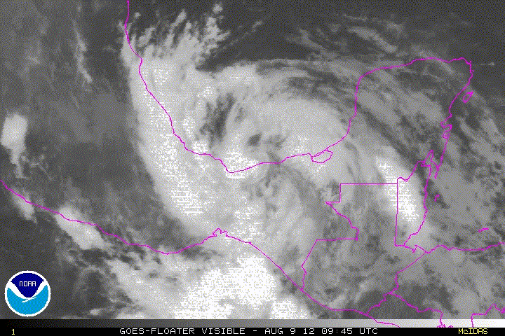
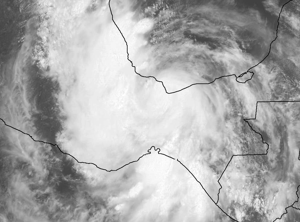
Mexico topography...he's got some mountains to get over now but not as high as the ones to his north...we'll see.

0 likes
This post is NOT AN OFFICIAL FORECAST and should not be used as such. It is just the opinion of the poster and may or may not be backed by sound meteorological data. It is NOT endorsed by any professional institution including storm2k.org. For Official Information please refer to the NHC and NWS products.

For now its moving over quite flat land but it will hit some harsh ground soon enough. Still the presentation of this system is very good right now, good job it didn't have more space.
0 likes
Personal Forecast Disclaimer:
The posts in this forum are NOT official forecast and should not be used as such. They are just the opinion of the poster and may or may not be backed by sound meteorological data. They are NOT endorsed by any professional institution or storm2k.org. For official information, please refer to the NHC and NWS products
The posts in this forum are NOT official forecast and should not be used as such. They are just the opinion of the poster and may or may not be backed by sound meteorological data. They are NOT endorsed by any professional institution or storm2k.org. For official information, please refer to the NHC and NWS products
-
floridasun78
- Category 5

- Posts: 3755
- Joined: Sun May 17, 2009 10:16 pm
- Location: miami fl
-
StormingB81

- S2K Supporter
- Posts: 5676
- Age: 44
- Joined: Thu Aug 27, 2009 1:45 am
- Location: Rockledge, Florida
-
tolakram
- Admin

- Posts: 20178
- Age: 62
- Joined: Sun Aug 27, 2006 8:23 pm
- Location: Florence, KY (name is Mark)
Re: ATL: ERNESTO - Tropical Storm
Another blowup over or near the center.
0 likes
M a r k
- - - - -
Join us in chat: Storm2K Chatroom Invite. Android and IOS apps also available.
The posts in this forum are NOT official forecasts and should not be used as such. Posts are NOT endorsed by any professional institution or STORM2K.org. For official information and forecasts, please refer to NHC and NWS products.
-
Florida1118
Re:
StormingB81 wrote:Question: Now I am sure this has been asked but I have never seen it so I do appoligize. IF Ernesto survives and makes it to the EPAC and reforms stays intact whatever. Does it stay as Ernesto or does it assume an EPAC name? Thank you
He would keep his name, though it has not happened before that I am aware of.
0 likes
-
StormingB81
- S2K Supporter
- Posts: 5676
- Age: 44
- Joined: Thu Aug 27, 2009 1:45 am
- Location: Rockledge, Florida
-
Portastorm

- Storm2k Moderator

- Posts: 9954
- Age: 63
- Joined: Fri Jul 11, 2003 9:16 am
- Location: Round Rock, TX
- Contact:
Re: Re:
Florida1118 wrote:StormingB81 wrote:Question: Now I am sure this has been asked but I have never seen it so I do appoligize. IF Ernesto survives and makes it to the EPAC and reforms stays intact whatever. Does it stay as Ernesto or does it assume an EPAC name? Thank you
He would keep his name, though it has not happened yet before that I am aware of.
We talked about this yesterday some. You're correct (about keeping the name) and the last time it happened was 1996.
0 likes
Any forecasts under my name are to be taken with a grain of salt. Get your best forecasts from the National Weather Service and National Hurricane Center.
-
tolakram
- Admin
- Posts: 20178
- Age: 62
- Joined: Sun Aug 27, 2006 8:23 pm
- Location: Florence, KY (name is Mark)
Re: ATL: ERNESTO - Tropical Storm
0 likes
M a r k
- - - - -
Join us in chat: Storm2K Chatroom Invite. Android and IOS apps also available.
The posts in this forum are NOT official forecasts and should not be used as such. Posts are NOT endorsed by any professional institution or STORM2K.org. For official information and forecasts, please refer to NHC and NWS products.
- - - - -
Join us in chat: Storm2K Chatroom Invite. Android and IOS apps also available.
The posts in this forum are NOT official forecasts and should not be used as such. Posts are NOT endorsed by any professional institution or STORM2K.org. For official information and forecasts, please refer to NHC and NWS products.
-
cycloneye

- Admin
- Posts: 149275
- Age: 69
- Joined: Thu Oct 10, 2002 10:54 am
- Location: San Juan, Puerto Rico
Re: ATL: ERNESTO - Advisories
BULLETIN
TROPICAL STORM ERNESTO INTERMEDIATE ADVISORY NUMBER 33A
NWS NATIONAL HURRICANE CENTER MIAMI FL AL052012
100 PM CDT THU AUG 09 2012
...TORRENTIAL RAINS AND FLOODING ANTICIPATED AS ERNESTO SKIRTS THE
COAST OF MEXICO NEAR COATZACOALCOS...
SUMMARY OF 100 PM CDT...1800 UTC...INFORMATION
----------------------------------------------
LOCATION...18.2N 94.6W
ABOUT 5 MI...10 KM N OF COATZACOALCOS MEXICO
MAXIMUM SUSTAINED WINDS...60 MPH...95 KM/H
PRESENT MOVEMENT...W OR 260 DEGREES AT 5 MPH...7 KM/H
MINIMUM CENTRAL PRESSURE...992 MB...29.29 INCHES
WATCHES AND WARNINGS
--------------------
CHANGES WITH THIS ADVISORY...
NONE.
SUMMARY OF WATCHES AND WARNINGS IN EFFECT...
A TROPICAL STORM WARNING IS IN EFFECT FOR...
* VERACRUZ TO CHILITEPEC MEXICO
FOR STORM INFORMATION SPECIFIC TO YOUR AREA ...PLEASE MONITOR
PRODUCTS ISSUED BY YOUR NATIONAL METEOROLOGICAL SERVICE.
DISCUSSION AND 48-HOUR OUTLOOK
------------------------------
SURFACE OBSERVATIONS FROM MEXICO INDICATE THAT THE ERNESTO HAS BEEN
SKIRTING THE COAST IN THE VICINITY OF COATZACOALCOS. AT 100 PM
CDT...1800 UTC...THE CENTER WAS LOCATED NEAR LATITUDE 18.2 NORTH...
LONGITUDE 94.6 WEST. ERNESTO HAS BEEN DRIFTING WESTWARD NEAR 5
MPH...7 KM/H. A GENERAL SLOW MOTION TOWARD THE WEST OR
WEST-SOUTHWEST IS EXPECTED DURING THE NEXT DAY OR TWO. ON THE
FORECAST TRACK...ERNESTO WILL BE MOVING OVER SOUTHERN MEXICO LATER
TODAY AND FRIDAY.
MAXIMUM SUSTAINED WINDS REMAIN NEAR 60 MPH...95 KM/H...WITH HIGHER
GUSTS. THESE STRONG WINDS ARE OCCURRING PRIMARILY OVER WATER NORTH
OF THE CENTER. WEAKENING IS FORECAST DURING THE NEXT 48 HOURS AS
THE CENTER OF ERNESTO MOVES OVER THE HIGH TERRAIN OF MEXICO.
TROPICAL STORM FORCE WINDS EXTEND OUTWARD UP TO 140 MILES...220 KM
MAINLY TO THE NORTH OF THE CENTER.
THE ESTIMATED MINIMUM CENTRAL PRESSURE IS 992 MB...29.29 INCHES.
HAZARDS AFFECTING LAND
----------------------
WIND...TROPICAL STORM CONDITIONS WILL CONTINUE TO SPREAD WESTWARD
ACROSS THE TROPICAL STORM WARNING AREA TODAY.
RAINFALL...ERNESTO IS EXPECTED TO PRODUCE TOTAL RAINFALL
ACCUMULATIONS OF 5 TO 10 INCHES WITH ISOLATED MAXIMUM AMOUNTS OF 15
INCHES OVER THE MEXICAN STATES OF VERACRUZ...TABASCO...PUEBLA...AND
OAXACA THROUGH FRIDAY. THESE RAINS MAY PRODUCE LIFE-THREATENING
FLASH FLOODS AND MUD SLIDES OVER AREAS OF HIGHER TERRAIN.
STORM SURGE...A STORM SURGE OF 1 TO 3 FEET ABOVE NORMAL TIDE LEVELS
IS POSSIBLE IN AREAS OF ONSHORE WINDS IN THE WARNING AREA ALONG THE
GULF COAST OF MEXICO. NEAR THE COAST...THE SURGE WILL BE ACCOMPANIED
BY LARGE AND DANGEROUS WAVES.
NEXT ADVISORY
-------------
NEXT COMPLETE ADVISORY...400 PM CDT.
$$
FORECASTER AVILA
0 likes
Visit the Caribbean-Central America Weather Thread where you can find at first post web cams,radars
and observations from Caribbean basin members Click Here
and observations from Caribbean basin members Click Here
-
StormingB81
- S2K Supporter
- Posts: 5676
- Age: 44
- Joined: Thu Aug 27, 2009 1:45 am
- Location: Rockledge, Florida

Re: ATL: ERNESTO - Tropical Storm
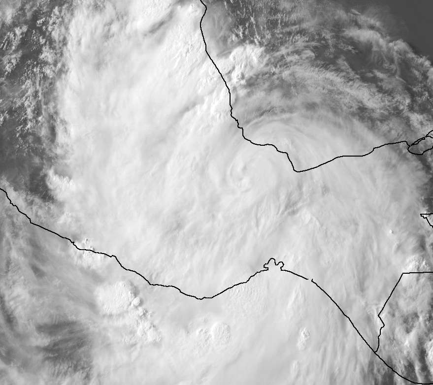
Ernesto's final (or maybe not final?) burst is occurring in an impressive fashion. Despite being right on Mexico now at the furthest southern point in the BOC, a spinning top motion and new convective burst is occurring like he's strengthening! The upper levels must be perfect for such. If it took Gilbert's or Karl's track it might have gone through RI based on how well its doing now that close to landmass.
With that said, the rainfall and flooding look to be tremendous based on IR. It's in a perfect position and scenario to deliver the maximum amount of rain possible (like Debby only more impressive) on Mexico. It wouldn't surprise me to find the amounts going over 20 to 25 inches in some areas. I didn't hear much about preparations for this so the news could be bad.
The movement and track are also unique because it took a SW dive and maybe Ernesto could do that again. A lot of its southern convection is in the Epac now and wouldn't it be cool if it went due south directly down there.
Yesterday's Posts:
LOL. Even when recon is needed the most and at the most critical time to sample his peak winds, it fails. A perfect way to top off a pathetic system despite Ernesto becoming a 'cane and having a more impressive appearance in general during the last 48 hours.
Umm, how can Ernesto still be a hurricane at 60 knots? And then just as I refreshed the page, they corrected it.
LOL. I've never seen this happen but I want to read the advisory. Anyone catch it? Just a yes or no so I don't waste time looking through dozens of pages in this thread...maybe the advisories thread?
With that said, the rainfall and flooding look to be tremendous based on IR. It's in a perfect position and scenario to deliver the maximum amount of rain possible (like Debby only more impressive) on Mexico. It wouldn't surprise me to find the amounts going over 20 to 25 inches in some areas. I didn't hear much about preparations for this so the news could be bad.
The movement and track are also unique because it took a SW dive and maybe Ernesto could do that again. A lot of its southern convection is in the Epac now and wouldn't it be cool if it went due south directly down there.
Yesterday's Posts:
NHC Discussion at 11:00 pm EDT wrote:TECHNICAL ISSUES PREVENTED A RECON FLIGHT FROM INVESTIGATING ERNESTO THIS EVENING.
LOL. Even when recon is needed the most and at the most critical time to sample his peak winds, it fails. A perfect way to top off a pathetic system despite Ernesto becoming a 'cane and having a more impressive appearance in general during the last 48 hours.
NHC Discussion at 5:00 am EDT wrote:HURRICANE ERNESTO DISCUSSION NUMBER 28
NWS NATIONAL HURRICANE CENTER MIAMI FL AL052012
400 AM CDT WED AUG 08 2012
RADAR DATA FROM BELIZE SHOW THAT ERNESTO MADE LANDFALL ALONG THE
EAST COAST OF YUCATAN PENINSULA OF MEXICO AROUND THE TIME OF THE
PREVIOUS ADVISORY. SHORTLY BEFORE LANDFALL...AN AUTOMATED WEATHER
STATION ON BANCO CHINCHORRO ISLAND JUST OFF THE COAST OF MEXICO
REPORTED A MINIMUM PRESSURE OF 979.4 MB. SINCE THAT TIME...THE
CENTER OF ERNESTO HAS MOVED WESTWARD OVER THE SOUTHERN PORTION OF
THE YUCATAN PENINSULA. DURING THE PAST COUPLE OF HOURS THE EYE HAS
BECOME A LITTLE LESS DISTINCT IN RADAR IMAGERY...AND THE LAST COUPLE
OF GEOSTATIONARY SATELLITE PICTURES SHOW THE CLOUD TOPS WARMING.
THE INITIAL INTENSITY IS THEREFORE LOWERED TO 60 KT.
Umm, how can Ernesto still be a hurricane at 60 knots? And then just as I refreshed the page, they corrected it.
NHC Update at 4:00 pm EDT wrote:000
WTNT65 KNHC 081957
TCUAT5
TROPICAL STORM ERNESTO TROPICAL CYCLONE UPDATE
NWS NATIONAL HURRICANE CENTER MIAMI FL AL052012
300 PM CDT WED AUG 08 2012
A VERSION OF THE 4 PM CDT TROPICAL CYCLONE DISCUSSION FOR TROPICAL
STORM ERNESTO WAS INADVERTENTLY SENT EARLY. THE CORRECT VERSION OF
THIS PRODUCT WILL BE RE-TRANSMITTED AT THE USUAL TRANSMISSION TIME.
$$
FORECASTER PASCH
LOL. I've never seen this happen but I want to read the advisory. Anyone catch it? Just a yes or no so I don't waste time looking through dozens of pages in this thread...maybe the advisories thread?
0 likes

Eastern Pacific TWO
WITHIN THE NEXT COUPLE OF DAYS...A TROUGH OF LOW PRESSURE ALONG THE
WEST COAST OF MEXICO COULD BEGIN TO INTERACT WITH THE REMNANTS OF
ATLANTIC TROPICAL STORM ERNESTO. UPPER-LEVEL WINDS ARE ONLY
MARGINALLY CONDUCIVE FOR DEVELOPMENT...AND THERE IS A LOW CHANCE...
10 PERCENT...OF TROPICAL CYCLONE FORMATION OFF THE WEST-CENTRAL
COAST OF MEXICO DURING THE NEXT 48 HOURS.
0 likes
-
Kingarabian

- S2K Supporter
- Posts: 16348
- Joined: Sat Aug 08, 2009 3:06 am
- Location: Honolulu, Hawaii
-
cycloneye
- Admin
- Posts: 149275
- Age: 69
- Joined: Thu Oct 10, 2002 10:54 am
- Location: San Juan, Puerto Rico
Re: ATL: ERNESTO - Advisories
TROPICAL STORM ERNESTO DISCUSSION NUMBER 34
NWS NATIONAL HURRICANE CENTER MIAMI FL AL052012
400 PM CDT THU AUG 09 2012
SURFACE OBSERVATIONS FROM MEXICO INDICATE THAT ERNESTO MADE LANDFALL
ON THE COAST OF MEXICO JUST WEST OF THE CITY OF COATZACOALCOS AROUND
1800 UTC WITH AN ESTIMATED INTENSITY OF 50 KNOTS. SINCE THEN...
ERNESTO HAS MOVED FARTHER INLAND AND BEGUN TO WEAKEN GRADUALLY. THE
INITIAL INTENSITY HAS BEEN LOWERED TO 45 KNOTS...AND THESE WINDS
ARE PRIMARILY OCCURRING OVER WATER NORTH OF THE CENTER.
SINCE THE CENTER IS FORECAST TO MOVE FARTHER INLAND AND INTERACT
WITH HIGH TERRAIN...WEAKENING IS FORECAST. ERNESTO IS LIKELY TO
BECOME A REMANT LOW IN ABOUT A DAY OR TWO...HOWEVER TORRENTIAL
RAINS WILL CONTINUE...AND WILL LIKELY PRODUCE FLASH FLOODING OVER
MUCH OF SOUTHERN MEXICO FOR THE NEXT FEW DAYS.
THE BEST ESTIMATE OF THE INITIAL MOTION IS 265 DEGREES AT 9 KNOTS.
ERNESTO IS WELL EMBEDDED WITHIN THE FLOW SOUTH OF A HIGH PRESSURE
AREA...OVER NORTHERN MEXICO AND THE SOUTHERN UNITED STATES. THIS
FLOW PATTERN WILL FORCE ERNESTO ON A GENERAL WEST TO WEST-SOUTHWEST
TRACK OVER SOUTHERN MEXICO UNTIL DISSIPATION IN A DAY OR TWO.
ALTHOUGH ERNESTO IS FORECAST TO DISSIPATE OVER THE HIGH MOUNTAINS OF
MEXICO...GLOBAL MODELS ARE SUGGESTING A NEW TROPICAL CYCLONE COULD
DEVELOP IN THE EASTERN PACIFIC ASSOCIATED WITH THE MID-LEVEL
REMNANT CIRCULATION IN 3 DAYS OR SO.
FORECAST POSITIONS AND MAX WINDS
INIT 09/2100Z 18.1N 95.2W 45 KT 50 MPH...INLAND
12H 10/0600Z 18.0N 96.5W 30 KT 35 MPH...INLAND
24H 10/1800Z 17.5N 99.0W 25 KT 30 MPH...INLAND
36H 11/0600Z 17.5N 101.5W 20 KT 25 MPH...POST-TROP/REMNT LOW
48H 11/1800Z...DISSIPATED
$$
FORECASTER AVILA
0 likes
Visit the Caribbean-Central America Weather Thread where you can find at first post web cams,radars
and observations from Caribbean basin members Click Here
and observations from Caribbean basin members Click Here
-
tolakram
- Admin
- Posts: 20178
- Age: 62
- Joined: Sun Aug 27, 2006 8:23 pm
- Location: Florence, KY (name is Mark)
Re: ATL: ERNESTO - Tropical Storm
Goodnight Ernesto
0 likes
M a r k
- - - - -
Join us in chat: Storm2K Chatroom Invite. Android and IOS apps also available.
The posts in this forum are NOT official forecasts and should not be used as such. Posts are NOT endorsed by any professional institution or STORM2K.org. For official information and forecasts, please refer to NHC and NWS products.
- - - - -
Join us in chat: Storm2K Chatroom Invite. Android and IOS apps also available.
The posts in this forum are NOT official forecasts and should not be used as such. Posts are NOT endorsed by any professional institution or STORM2K.org. For official information and forecasts, please refer to NHC and NWS products.
Should be getting pretty close to the rough ground now, thats where we see whether Ernesto can survive or not.
0 likes
Personal Forecast Disclaimer:
The posts in this forum are NOT official forecast and should not be used as such. They are just the opinion of the poster and may or may not be backed by sound meteorological data. They are NOT endorsed by any professional institution or storm2k.org. For official information, please refer to the NHC and NWS products
The posts in this forum are NOT official forecast and should not be used as such. They are just the opinion of the poster and may or may not be backed by sound meteorological data. They are NOT endorsed by any professional institution or storm2k.org. For official information, please refer to the NHC and NWS products
Who is online
Users browsing this forum: No registered users and 62 guests