Texas Summer 2012

U.S. & Caribbean Weather Discussions and Severe Weather Events

Moderator: S2k Moderators

Forum rules

The posts in this forum are NOT official forecast and should not be used as such. They are just the opinion of the poster and may or may not be backed by sound meteorological data. They are NOT endorsed by any professional institution or STORM2K.

Help Support Storm2K
Message
Author
User avatar
Rgv20
S2K Supporter
S2K Supporter
Posts: 2466
Age: 38
Joined: Wed Jan 05, 2011 5:42 pm
Location: Edinburg/McAllen Tx

#441 Postby Rgv20 » Mon Aug 13, 2012 7:33 am

0z and 6zGFS continue to hint at a possible weak tropical low taking shape in the Western GOM. As of right now it looks like this weekend is going to bring some beneficial rainfall to parts of Texas..fingers crossed! :D

Brownsville Morning Discussion.

"FRIDAY THROUGH THE WEEKEND GETS A LITTLE MORE COMPLICATED. OVERALL
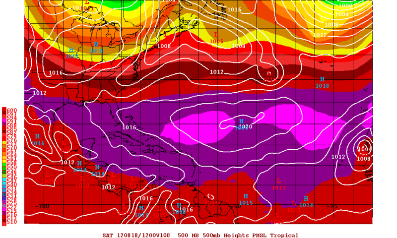
THE UPPER RIDGE OVER THE SOUTHWEST...AND BUILDING OVER THE WESTERN
GULF OF MEXICO...SLOWLY SLIDES WESTWARD AS A PARTICULARLY STRONG
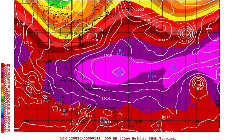
TROUGH DIGS INTO THE EASTERN CONUS. THE ECMWF IS SLOWER AND STRONGER
WITH THE TROUGH...AND ASSOCIATED FRONTAL BOUNDARY...BRINGING IT
CLOSE ENOUGH TO SOUTH TEXAS BY SUNDAY EVENING TO HAVE SOME FAIRLY
HIGH PRECIP CHANCES. THE GFS LOSES THE BOUNDARY SATURDAY EVENING
OVER EAST CENTRAL TEXAS...AND QUICKLY PROGRESSES THE OVERALL TROUGH
EASTWARD WITHOUT DIGGING QUITE AS FAR SOUTH. THE GFS AND DGEX BOTH
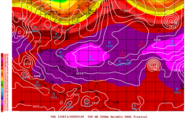
BRING A SOLID INVERTED TROUGH/WAVE THROUGH THE REGION UNDER THE
WEAKNESS IN THE UPPER RIDGE. THE ECMWF AND THE CANADIAN KEEP THAT
WAVE MUCH FURTHER SOUTH AND LIMIT OUR EXPOSURE TO A SMALL BUMP IN
PWATS BUT KEEP THE FRONT CLOSE ENOUGH TO WORK WITH IT TO GENERATE
SHRA/TSRA SUNDAY. GFS ENSEMBLE GUIDANCE IS PRETTY SOLID WITH THE
EASTERN US TROUGH...BUT SIGNIFICANTLY LESS CONVINCED ON THE HANDLING
OF THE STRENGTH OF THE WAVE TO OUR SOUTH. BELIEVE THAT THE GFS HAS
OVERDONE UPPER RIDGING IN RESPONSE TO THE WEAK TROUGH OVER THE
WESTERN GULF...WHICH BLOCKS THE ANOMALOUSLY STRONG UPPER TROUGH FROM
PUSHING SOUTH...SO WILL LEAN TOWARDS THE ECMWF FORECAST OVERALL. THIS
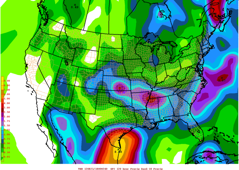
CALLS FOR A BUMP UP IN DEEP MOISTURE STARTING FRIDAY THROUGH
SATURDAY AND SUNDAY WITH 30 PERCENT RAIN CHANCES IN THE AFTERNOON
HOURS BOTH SATURDAY AND SUNDAY FOR NOW. TEMPERATURES STAY UP THROUGH
SATURDAY BUT I DID KNOCK THINGS DOWN A BIT FOR SUNDAY AND MONDAY
ASSUMING A LITTLE MORE MOISTURE/CLOUD COVER AND POSSIBLY PRECIP.
CONFIDENCE OF PRECIP AT SOME POINT DURING THE WEEKEND PERIOD IS
FAIRLY HIGH...BUT EXACT TIMING AND PLACEMENT DETAILS IS QUITE LOW
DUE TO THE COMPLICATED SCENARIO.
"
0 likes   
The following post is NOT an official forecast and should not be used as such. It is just the opinion of the poster and may or may not be backed by sound meteorological data. It is NOT endorsed by any professional institution including storm2k.org For Official Information please refer to the NHC and NWS products.

weatherdude1108
Category 5
Category 5
Posts: 4228
Joined: Tue Dec 13, 2011 1:04 pm
Location: Northwest Austin/Cedar Park, TX

Re:

#442 Postby weatherdude1108 » Mon Aug 13, 2012 8:02 am

Ntxw wrote:Sigh once again lots of rain all around me especially to the north and west, I got nothing. Hope you Austinites have better luck at that line overnight.


No luck here (sigh).
0 likes   

User avatar
Portastorm
Storm2k Moderator
Storm2k Moderator
Posts: 9914
Age: 62
Joined: Fri Jul 11, 2003 9:16 am
Location: Round Rock, TX
Contact:

Re: Re:

#443 Postby Portastorm » Mon Aug 13, 2012 8:55 am

weatherdude1108 wrote:
Ntxw wrote:Sigh once again lots of rain all around me especially to the north and west, I got nothing. Hope you Austinites have better luck at that line overnight.


No luck here (sigh).


Ditto. We got some clouds and more humidity. That was it. Although today there is a 20% chance that the outflow boundaries will cook up some storms once full heating occurs. We shall see.
0 likes   
Any forecasts under my name are to be taken with a grain of salt. Get your best forecasts from the National Weather Service and National Hurricane Center.

weatherdude1108
Category 5
Category 5
Posts: 4228
Joined: Tue Dec 13, 2011 1:04 pm
Location: Northwest Austin/Cedar Park, TX

#444 Postby weatherdude1108 » Mon Aug 13, 2012 9:20 am

Saw this local story from several days ago. Any thoughts out there on this? Warming or not, I know we have missed out on some tropical systems over at least the past year or so. Had we gotten the moisture falling in the right spots, our reservoirs would not be lower than last year and it would probably not be as serious a topic. I have also heard a warming atmosphere would INCREASE rainfall in Texas, not decrease as this article states. (Rainfall would DECREASE according to Dr. Kerry Cook.)

I think Dr. Nielsen-Gammon is the one who stated last year (correct me if I'm wrong) that overall rainfall would INCREASE over Texas, but evaporation rates would be higher. Seems to be conflicting information out there(?). Anyway. Food for thought I guess. :wink:

http://www.kxan.com/dpp/news/local/aust ... is-warming
0 likes   
The preceding post is NOT an official forecast, and should not be used as such. It is only the opinion of the poster and may or may not be backed by sound meteorological data. It is NOT endorsed by any professional institution including storm2k.org. For Official Information please refer to the NHC and NWS products.

User avatar
Ntxw
Storm2k Moderator
Storm2k Moderator
Posts: 22731
Joined: Wed Oct 21, 2009 6:34 pm
Location: DFW, Texas

Re:

#445 Postby Ntxw » Mon Aug 13, 2012 1:17 pm

Ntxw wrote:Ah the dog days of summer continues. Still no changes in that the first half of August will remain hot and dry for most of the state. Wild card continues to be the waves off the African coast but not very confident they will provide much relief for us. PNA remains negative and should straddle neutral for awhile.


Was a good idea heading into August. Now that the first half is gone, lets talk about the second half. CPC likes the idea of a somewhat "cool" period to round out August for parts of Texas and wetter. Since the Nino is getting stronger I like this idea also. Probably more NW flow events that brings rain once or twice a week. PNA+ is a good sign coupled with -AO. "Cooler" air looks like it will arrive a bit sooner than Sept. Still not seeing any real help from tropics though BOC keeps showing up on models. They have done it several times this year though and not really come to fruition.
0 likes   
The above post and any post by Ntxw is NOT an official forecast and should not be used as such. It is just the opinion of the poster and may or may not be backed by sound meteorological data. It is NOT endorsed by any professional institution including Storm2k. For official information, please refer to NWS products.

  Help support Storm2K!
Help Support Storm2K

User avatar
Portastorm
Storm2k Moderator
Storm2k Moderator
Posts: 9914
Age: 62
Joined: Fri Jul 11, 2003 9:16 am
Location: Round Rock, TX
Contact:

Re: Texas Summer 2012

#446 Postby Portastorm » Mon Aug 13, 2012 1:19 pm

:uarrow:

I wonder what, if any, influence we'll see from tropical action in the Pacific. Sometimes a Nino can throw a hurricane or two our way across Mexico. But that seems to usually happen later in September and October.
0 likes   
Any forecasts under my name are to be taken with a grain of salt. Get your best forecasts from the National Weather Service and National Hurricane Center.

User avatar
Ntxw
Storm2k Moderator
Storm2k Moderator
Posts: 22731
Joined: Wed Oct 21, 2009 6:34 pm
Location: DFW, Texas

Re: Texas Summer 2012

#447 Postby Ntxw » Mon Aug 13, 2012 1:24 pm

Portastorm wrote::uarrow:

I wonder what, if any, influence we'll see from tropical action in the Pacific. Sometimes a Nino can throw a hurricane or two our way across Mexico. But that seems to usually happen later in September and October.


I think it's a very good possibility these fronts will be enhanced by it! Storm or no storm in EPAC convection there is very high (MJO) and sets up for Sept!
0 likes   
The above post and any post by Ntxw is NOT an official forecast and should not be used as such. It is just the opinion of the poster and may or may not be backed by sound meteorological data. It is NOT endorsed by any professional institution including Storm2k. For official information, please refer to NWS products.


  Help support Storm2K!

Help Support Storm2K


weatherdude1108
Category 5
Category 5
Posts: 4228
Joined: Tue Dec 13, 2011 1:04 pm
Location: Northwest Austin/Cedar Park, TX

#448 Postby weatherdude1108 » Mon Aug 13, 2012 3:15 pm

I'm planning on trimming the yard this coming weekend. I may have to rethink my plans.:eek: :wink: I'm obviously biased towards the CMC and ECMWF models.:wink:

AREA FORECAST DISCUSSION
NATIONAL WEATHER SERVICE AUSTIN/SAN ANTONIO TX
251 PM CDT MON AUG 13 2012

.DISCUSSION...
THE NWLY MID LEVEL FLOW HAS PUSHED A FRONTAL BOUNDARY INTO THE
NRN PART OF THE REGION THAT WILL BE A FOCUS FOR CONVECTION THE
REMAINDER OF TODAY. HIGH BASED CONVECTION DEVELOPING OVER THE
CENTRAL/SRN HILL COUNTRY TO ALONG THE ESCARPMENT AND EDWARDS
PLATEAU THIS AFTERNOON. THIS CONVECTION WAS FORMING NEAR A SURFACE
FRONTAL BOUNDARY THAT WILL CONTINUE TO DRIFT SOUTHWARD INTO THE
EVENING HOURS WITH THE POTENTIAL FOR DAMAGING DOWNBURST WINDS.
ALTHOUGH GENERALLY ISOLATED COVERAGE EXPECTED...CLUSTERS OF
STORMS COULD RESULT IN AREAS OF SCATTERED COVERAGE...ESPECIALLY
BEFORE SUNSET OVER THE WESTERN AREAS WHERE LOW LEVEL CONVERGENCE
IS A BIT STRONGER. OTHERWISE THE UPPER RIDGE WILL REESTABLISHES
ITSELF THROUGH THE MID WEEK...ALTHOUGH THE RIDGE WILL NOT BE AS
STRONG AS LAST WEEK.

THERE CONTINUES TO BE GOOD INDICATIONS OF MUCH IMPROVING RAIN
CHANCES LATE THIS WEEK AND ESPECIALLY INTO THE WEEKEND/EARLY
NEXT WEEK.
A REDEVELOPING NWLY FLOW AND WEAKENING UPPER RIDGE OVER
TX WILL BRING ANOTHER FRONTAL BOUNDARY INTO S CENTRAL TX OVER THE
WEEKEND. THIS BOUNDARY COULD STALL AND BECOME NEARLY STATIONARY
OVER THE AREA AND PROVIDE A FOCUS FOR ORGANIZED CONVECTION.
THE
BIG QUESTION WILL BE HOW MUCH MOISTURE WILL INTERACT WITH THE
FRONTAL BOUNDARY. THE GFS SHOWS CONTINUED SHALLOW MOISTURE AND
SPOTTY RAINS SIMILAR TODAY AND LAST WEEK. WHILE THE CMC AND ECMWF
MODELS INDICATE DEEPER MOISTURE AND MORE ORGANIZED CONVECTION
NEAR THE LINGERING SURFACE BOUNDARY OVER THE WEEKEND.
WILL
CONTINUE WITH SLIGHT TO LOW CHANCE POPS FOR FRIDAY-MONDAY...
ALTHOUGH POPS COULD BE SIGNIFICANTLY HIGHER WITH A DEEPER
MOISTURE FIELD.
0 likes   
The preceding post is NOT an official forecast, and should not be used as such. It is only the opinion of the poster and may or may not be backed by sound meteorological data. It is NOT endorsed by any professional institution including storm2k.org. For Official Information please refer to the NHC and NWS products.

User avatar
Portastorm
Storm2k Moderator
Storm2k Moderator
Posts: 9914
Age: 62
Joined: Fri Jul 11, 2003 9:16 am
Location: Round Rock, TX
Contact:

Re: Texas Summer 2012

#449 Postby Portastorm » Mon Aug 13, 2012 4:39 pm

As of 4:40 pm this Monday, radar looks promising for us in Austin. Will it poof? Will it rain?
0 likes   
Any forecasts under my name are to be taken with a grain of salt. Get your best forecasts from the National Weather Service and National Hurricane Center.

weatherdude1108
Category 5
Category 5
Posts: 4228
Joined: Tue Dec 13, 2011 1:04 pm
Location: Northwest Austin/Cedar Park, TX

#450 Postby weatherdude1108 » Mon Aug 13, 2012 6:43 pm

:D IT RAINED at the Weatherdude1108 Center!! Woohoo!

Moderately with lightning and thunder.

1 month and 1 day later.
0 likes   

User avatar
Rgv20
S2K Supporter
S2K Supporter
Posts: 2466
Age: 38
Joined: Wed Jan 05, 2011 5:42 pm
Location: Edinburg/McAllen Tx

#451 Postby Rgv20 » Mon Aug 13, 2012 7:33 pm

The GFS continues to hint at a possible weak tropical low taking shape in the Western GOM by this Weekend. The well advertised strong Trough is going to set up a weakness in the Ridge by this weekend which could result in a fairly stagnant pattern. This pattern will favor steering current to be quite low and whatever energy (TD7?) is in the BOC/SW Gulf will have enough time to organize and grow until something more substantial. Of course all of these really depends as to where a low will take form as some of the GFS runs/Ensembles show the energy staying inland in the coast of Mexico.

To make a long story short the end result could be something like this.....18zGFS 6-10 Total Rainfall Forecast :eek:

Image
0 likes   
The following post is NOT an official forecast and should not be used as such. It is just the opinion of the poster and may or may not be backed by sound meteorological data. It is NOT endorsed by any professional institution including storm2k.org For Official Information please refer to the NHC and NWS products.

User avatar
Ntxw
Storm2k Moderator
Storm2k Moderator
Posts: 22731
Joined: Wed Oct 21, 2009 6:34 pm
Location: DFW, Texas

Re: Texas Summer 2012

#452 Postby Ntxw » Mon Aug 13, 2012 10:27 pm

Digging for my poncho after seeing hpc forecast. Now we just need a BOC feature to fill the rest of the gap. :rain:

Image

Image
0 likes   
The above post and any post by Ntxw is NOT an official forecast and should not be used as such. It is just the opinion of the poster and may or may not be backed by sound meteorological data. It is NOT endorsed by any professional institution including Storm2k. For official information, please refer to NWS products.


  Help support Storm2K!

Help Support Storm2K


weatherdude1108
Category 5
Category 5
Posts: 4228
Joined: Tue Dec 13, 2011 1:04 pm
Location: Northwest Austin/Cedar Park, TX

#453 Postby weatherdude1108 » Mon Aug 13, 2012 10:39 pm

Bob Rose says this week may be the last week of intense 100s. Good riddance! :grrr:

In addition, may see more tropical activity and possibly interaction of the stalled out cold front when it meanders over the Gulf of Mexico.

I remember in 1998 in San Antonio, we had a combination of a tropical tap from the Gulf of Mexico, moisture from the Pacific, and an upper level low coming across the area stirring it all up. Created the perfect storm of flooding over south-central Texas. Wild stuff! :eek:

Bob Rose blog
http://www.lcra.org/water/conditions/we ... olumn.html

1998 Flood
http://pubs.usgs.gov/fs/FS-147-99/
0 likes   
The preceding post is NOT an official forecast, and should not be used as such. It is only the opinion of the poster and may or may not be backed by sound meteorological data. It is NOT endorsed by any professional institution including storm2k.org. For Official Information please refer to the NHC and NWS products.

User avatar
Rgv20
S2K Supporter
S2K Supporter
Posts: 2466
Age: 38
Joined: Wed Jan 05, 2011 5:42 pm
Location: Edinburg/McAllen Tx

#454 Postby Rgv20 » Mon Aug 13, 2012 11:48 pm

Well tonight's 0zGFS continues to hint at a possible TC forming in the Western Gulf....The ECMWF has not been showing any type of organize disturbance as it keeps most of the energy in the Mexican Coast. Its hard to ignore the GFS as it has descent Ensemble Support and not to mention it has done very well so far this Hurricane Season. Interesting days ahead! :D


By Saturday morning the GFS starts organizing a weak area of low pressure in the BOC.
Image


By Sunday Evening it looks like it is very close to making landfall in Central Mexico.
Image


By Monday Evening it looks like it drifted North while intensifying.
Image


EDIT: Look at those Crazy Forecast Rainfall totals from the GFS for Days 6-10! :eek:

Image
0 likes   
The following post is NOT an official forecast and should not be used as such. It is just the opinion of the poster and may or may not be backed by sound meteorological data. It is NOT endorsed by any professional institution including storm2k.org For Official Information please refer to the NHC and NWS products.

weatherdude1108
Category 5
Category 5
Posts: 4228
Joined: Tue Dec 13, 2011 1:04 pm
Location: Northwest Austin/Cedar Park, TX

Re:

#455 Postby weatherdude1108 » Tue Aug 14, 2012 8:15 am

Rgv20 wrote:Well tonight's 0zGFS continues to hint at a possible TC forming in the Western Gulf....The ECMWF has not been showing any type of organize disturbance as it keeps most of the energy in the Mexican Coast. Its hard to ignore the GFS as it has descent Ensemble Support and not to mention it has done very well so far this Hurricane Season. Interesting days ahead! :D


By Saturday morning the GFS starts organizing a weak area of low pressure in the BOC.
Image


By Sunday Evening it looks like it is very close to making landfall in Central Mexico.
Image


By Monday Evening it looks like it drifted North while intensifying.
Image


EDIT: Look at those Crazy Forecast Rainfall totals from the GFS for Days 6-10! :eek:

Image


WOW! Interesting how there is a prediction of over nine inches south of San Antonio near Pleasanton and absolutely nothing north of Travis County(??). If you could spread those totals up to encompass that infamous bubble in Central and West Central Texas, it would be very beneficial to those who have little to no water flow in the watersheds! :wink:
0 likes   

User avatar
Rgv20
S2K Supporter
S2K Supporter
Posts: 2466
Age: 38
Joined: Wed Jan 05, 2011 5:42 pm
Location: Edinburg/McAllen Tx

#456 Postby Rgv20 » Tue Aug 14, 2012 2:45 pm

Afternoon discussion from the NWS Brownsville......They are buying the GFS solution.

"BY THE WEEKEND...UPPER HIGH OVER THE WEST WITH A DEEP TROUGH
COVERING MOST OF THE EASTERN PORTION OF THE STATE WILL HELP FRONT
MOVE FURTHER SOUTH INTO CENTRAL TEXAS BY LATE INTO THE WEEKEND.
FURTHER SOUTH...REMNANTS OF TROPICAL DEPRESSION 7 WILL MOVE OVER THE
BAY OF CAMPECHE WITH MODELS HINTING ON BECOMING A CLOSED LOW BY LATE
SUNDAY. DISAGREEMENT BETWEEN THE GFS AND ECMWF BEGIN FROM DAY 6 AS
GFS BRINGS THIS SYSTEM NORTH ALONG THE COASTLINE WHILE ECMWF KEEPS A
VERY DISORGANIZED AREA OF THUNDERSTORMS MOVING ACROSS CENTRAL
AMERICA. LEAN TOWARDS THE GFS FOR DAY 6 AT THIS TIME WITH AN
INCREASE IN WINDS AS THIS SYSTEM MOVES INTO THE BAY OF CAMPECHE AND
POPS ALONG THE COASTLINE. THERE IS A LOT OF UNCERTAINTY ON WHAT THIS
TROPICAL WAVE WILL DO ONCE IT MOVES OVER THE BAY OF CAMPECHE IF IT
DOES."


Interesting info out of the HPC....NHC forecasting a tropical low in the Western GOM..

FINAL...

MADE ONLY COSMETIC CHANGES TO THE UPDATE PACKAGE FOR THE FINAL
ISSUANCE. THE 12Z/14 GFS AND GEFS MEAN HAVE TRENDED STRONGLY
TOWARD THE EUROPEAN CENTRE GUIDANCE AT THE END OF THE PERIOD...NOW
INDICATING PRIMACY OF THE LONGWAVE TROUGH OVER THE EAST.
COORDINATION WITH THE NATIONAL HURRICANE CENTER RESULTED IN THE
INTRODUCTION OF A SPOT TROPICAL LOW CREEPING UP THE ATLANTIC SIDE
OF THE MEXICAN COAST THROUGH MID PERIOD. EVEN IF NO ORGANIZED
SYSTEM DEVELOPS...THE TROPICAL FEED MAY WELL INTERSECT THE EDGE OF
THE WESTERLIES OVER SOUTHERN TEXAS...ENHANCING RAINFALL THERE.
0 likes   
The following post is NOT an official forecast and should not be used as such. It is just the opinion of the poster and may or may not be backed by sound meteorological data. It is NOT endorsed by any professional institution including storm2k.org For Official Information please refer to the NHC and NWS products.

User avatar
Ntxw
Storm2k Moderator
Storm2k Moderator
Posts: 22731
Joined: Wed Oct 21, 2009 6:34 pm
Location: DFW, Texas

#457 Postby Ntxw » Tue Aug 14, 2012 3:02 pm

Brownsville knows their stuff! Agree even if no defined system forms lots of moisture feed on both sides. Just take a look, ribbon of moisture courtesy of the Pacific. Plenty of rain to go around! Except the bubble that is Austin :wink:

Image
0 likes   
The above post and any post by Ntxw is NOT an official forecast and should not be used as such. It is just the opinion of the poster and may or may not be backed by sound meteorological data. It is NOT endorsed by any professional institution including Storm2k. For official information, please refer to NWS products.


  Help support Storm2K!

Help Support Storm2K


weatherdude1108
Category 5
Category 5
Posts: 4228
Joined: Tue Dec 13, 2011 1:04 pm
Location: Northwest Austin/Cedar Park, TX

#458 Postby weatherdude1108 » Tue Aug 14, 2012 3:54 pm

The bubble that is the Austin/San Antonio office is also talking of a pattern change. We'll see how this bubble holds up under the pressure. :wink:

000
FXUS64 KEWX 142030
AFDEWX

AREA FORECAST DISCUSSION
NATIONAL WEATHER SERVICE AUSTIN/SAN ANTONIO TX
330 PM CDT TUE AUG 14 2012

.DISCUSSION...
CUMULUS CONTINUE TO DEVELOP JUST NORTH OF OUR AREA AND ARE
BEGINNING TO CONGEST FROM DFW DOWN TO BROWNWOOD. WE STILL EXPECT A
ISOLATED THUNDERSTORMS TO DEVELOP...BUT THE ONLY LOCATIONS WITH
ANY CHANCE FOR RAIN SHOULD BE LLANO...BURNET...AND WILLIAMSON
COUNTIES. THESE STORMS MAY PRODUCE GUSTY WINDS OF 40-50 MPH.

THE MAIN FORECAST ISSUE IS A PATTERN CHANGE FROM HOT AND DRY UNDER
THE PERSISTENT MID AND UPPER LEVEL RIDGE...TO WEAK NORTHWEST FLOW
ALOFT AND MOIST LOW LEVEL EASTERLY/SOUTHERLY FLOW.
THE GFS HAS
BEEN CONSISTENT IN PULLING UP THE REMNANTS FROM TD 7 INTO THE BAY
OF CAMPECHE...THEN DEVELOPING A TD OR EVEN TS AND BRINGING IT
INLAND NEAR BRO AND THEN UP THE LOWER RIO GRANDE VALLEY. WHILE
THAT IS OPTIMISTIC FOR BEYOND DAY 7...MUCH MORE LIKELY IS THE
PATTERN CHANGE...WHICH MEANS COOLER TEMPS...HIGHER POPS...AND SOME
RELIEF FROM THE DROUGHT AS THE NEXT SEVEN DAYS PROGRESS.
THE ACTUAL FORECAST THEN WILL BE FOR SLIGHTLY COOLER TEMPS AND
STILL DRY WED-FRI...SEA-BREEZE POPS RETURNING SAT-SUN...THEN MORE
WIDESPREAD POPS AND QPF MON-TUE AS AT LEAST THE HIGH PW MOIST AIR
MOVES NORTHWARD INTO THE AREA.

AGAIN...THE SITUATION FOR THE MIDDLE TO END OF NEXT WEEK MAY GET
INTERESTING IF THE GFS FULLY PANS OUT WITH FAVORABLE LOW-LEVEL
MOIST AIR AND ADEQUATE VENTILATION ALOFT IN NORTHWEST FLOW. THE
RESULT COULD BE NOT ONLY MUCH NEEDED RAIN...BUT FLASH FLOODING.
0 likes   
The preceding post is NOT an official forecast, and should not be used as such. It is only the opinion of the poster and may or may not be backed by sound meteorological data. It is NOT endorsed by any professional institution including storm2k.org. For Official Information please refer to the NHC and NWS products.

User avatar
Ntxw
Storm2k Moderator
Storm2k Moderator
Posts: 22731
Joined: Wed Oct 21, 2009 6:34 pm
Location: DFW, Texas

#459 Postby Ntxw » Tue Aug 14, 2012 5:29 pm

Portastorm: What Bubble?

Image

Any doubts of the Nino? :cheesy:
0 likes   
The above post and any post by Ntxw is NOT an official forecast and should not be used as such. It is just the opinion of the poster and may or may not be backed by sound meteorological data. It is NOT endorsed by any professional institution including Storm2k. For official information, please refer to NWS products.


  Help support Storm2K!

Help Support Storm2K


weatherdude1108
Category 5
Category 5
Posts: 4228
Joined: Tue Dec 13, 2011 1:04 pm
Location: Northwest Austin/Cedar Park, TX

#460 Postby weatherdude1108 » Tue Aug 14, 2012 10:01 pm

Bob Rose has similar outlook of a more realistic wetter scenario according to the models. We shall see. :lightning: :rain:

http://www.lcra.org/water/conditions/we ... olumn.html
0 likes   
The preceding post is NOT an official forecast, and should not be used as such. It is only the opinion of the poster and may or may not be backed by sound meteorological data. It is NOT endorsed by any professional institution including storm2k.org. For Official Information please refer to the NHC and NWS products.


Return to “USA & Caribbean Weather”

Who is online

Users browsing this forum: rwfromkansas, txtwister78 and 52 guests