That thing looks like a possible storm in the making, but I do believe the models are taking this off the coast too far north
The posts in this forum are NOT official forecast and should not be used as such. They are just the opinion of the poster and may or may not be backed by sound meteorological data. They are NOT endorsed by any professional institution or storm2k.org. For official information, please refer to the NHC and NWS products
Big wave emerging West Africa - (Is invest 94L)
Moderator: S2k Moderators
Forum rules

The posts in this forum are NOT official forecasts and should not be used as such. They are just the opinion of the poster and may or may not be backed by sound meteorological data. They are NOT endorsed by any professional institution or STORM2K. For official information, please refer to products from the National Hurricane Center and National Weather Service.
-
Hurricaneman

- Category 5

- Posts: 7404
- Age: 45
- Joined: Tue Aug 31, 2004 3:24 pm
- Location: central florida
-
cycloneye

- Admin

- Posts: 149511
- Age: 69
- Joined: Thu Oct 10, 2002 10:54 am
- Location: San Juan, Puerto Rico
Re: Blob over west Africa
As Aric said at the models thread,is at a fairly low latitude. Saved image.

0 likes
Visit the Caribbean-Central America Weather Thread where you can find at first post web cams,radars
and observations from Caribbean basin members Click Here
and observations from Caribbean basin members Click Here
-
cycloneye
- Admin
- Posts: 149511
- Age: 69
- Joined: Thu Oct 10, 2002 10:54 am
- Location: San Juan, Puerto Rico
Re: Blob over west Africa
Is now Pouch 15L
They start the first position at 14N.
http://www.met.nps.edu/~mtmontgo/synops ... 081500.txt
P15L
14N, 0E/W
700 hPa
ECMWF: Moves P15L relatively straight off of Africa and over the eastern Atlantic, intensifying a little as it moves over the ocean.
GFS: Eastern most initial OW max in a SW-NE line of several OW maxima. Entire line orients N-S, with P15L gaining quite a bit of latitude. Intensifies.
UKMET: Like GFS, UKMET moves northwestward early on, but then it develops another circulation farther to the west just off the African coast. P15L then turns westward and also heads westward, but it is weaker than the other circulation ahead of it.
NOGAPS: Like GFS & UKMET, NOGAPS depicts an initial SW-NE elongation. It takes a couple days (faster wave catching up with a slower one? Wave moving into monsoonal wrap-up?), but eventually one single pouch is depicted at 60 hours, which then tracks smoothly to the west with some intensification. Result is a westward track that is slower than ECMWF.
HWRF-GEN:
ECMWF -10.7 v700 120h
GFS -7.9 v700 120h
UKMET -8.6 v700 120h
NOGAPS -7.3 v700 120h
HWGEN ---- ---- ---h
0 likes
Visit the Caribbean-Central America Weather Thread where you can find at first post web cams,radars
and observations from Caribbean basin members Click Here
and observations from Caribbean basin members Click Here
-
Hurricaneman
- Category 5
- Posts: 7404
- Age: 45
- Joined: Tue Aug 31, 2004 3:24 pm
- Location: central florida
Re: Blob over west Africa (Pouch 15L)
The GFS12z seems to break this wave into 2 lows, one near 18 north and one near 10 north, could that be convective feedback or is this a possible scenerio, at least it shows this within a week
My forecast for this is that the 18 north low in 5 days dissipates or may not even exist, while the vorticity at 10 north comes off of Africa saturday and becomes an invest by monday, by Tuesday its declared a depression and by next Wednesday evening and named a Tropical storm by next Thursday and from there I'm not going to venture a guess
The posts in this forum are NOT official forecast and should not be used as such. They are just the opinion of the poster and may or may not be backed by sound meteorological data. They are NOT endorsed by any professional institution or storm2k.org. For official information, please refer to the NHC and NWS products
0 likes
-
Aric Dunn
- Category 5
- Posts: 21238
- Age: 43
- Joined: Sun Sep 19, 2004 9:58 pm
- Location: Ready for the Chase.
- Contact:
not likely convective feedback. more that part of the energy is drawn north and a the remaining low amplitude wave ( in a more conducive environment ) starts to develop while the northern part weakens over cooler water.
0 likes
Note: If I make a post that is brief. Please refer back to previous posts for the analysis or reasoning. I do not re-write/qoute what my initial post said each time.
If there is nothing before... then just ask
Space & Atmospheric Physicist, Embry-Riddle Aeronautical University,
I believe the sky is falling...
If there is nothing before... then just ask
Space & Atmospheric Physicist, Embry-Riddle Aeronautical University,
I believe the sky is falling...
-
cycloneye
- Admin
- Posts: 149511
- Age: 69
- Joined: Thu Oct 10, 2002 10:54 am
- Location: San Juan, Puerto Rico
Re: Blob over west Africa (Pouch 15L)
Here is the 00:45 UTC saved image where you can see how this wave looks prior from emerging West Africa. If you look closely,there is a circulation down in latitude around 11N-12N. By the way,you dont have to wait six hours for an updated image from Africa as these update every 15 minutes. Loop below image.

Here is a very nice loop. I recommend to those who may not have this site to bookmark it.
http://sat24.com/en/wa
Here is a very nice loop. I recommend to those who may not have this site to bookmark it.
http://sat24.com/en/wa
0 likes
Visit the Caribbean-Central America Weather Thread where you can find at first post web cams,radars
and observations from Caribbean basin members Click Here
and observations from Caribbean basin members Click Here
-
Riptide

- Category 2

- Posts: 753
- Age: 34
- Joined: Fri Jul 23, 2010 3:33 pm
- Location: Cape May, New Jersey
- Contact:
Re: Blob over west Africa (Pouch 15L)
0z GFS more enthusiastic about Pouch 15L...probably the most legitimate threat of the year to date.

0 likes

GFS and ECM are both developing this one, as are most of the GFS ensembles as well so good support for this one to develop, and as it won't shoot NW like Gordon did, chances of early development look higher with this one. Think its probably going to be a long tracker, and early stages but a recurve looking probable again, but IMO a track threating Bermuda is at least a threat if nothing else.
0 likes
Personal Forecast Disclaimer:
The posts in this forum are NOT official forecast and should not be used as such. They are just the opinion of the poster and may or may not be backed by sound meteorological data. They are NOT endorsed by any professional institution or storm2k.org. For official information, please refer to the NHC and NWS products
The posts in this forum are NOT official forecast and should not be used as such. They are just the opinion of the poster and may or may not be backed by sound meteorological data. They are NOT endorsed by any professional institution or storm2k.org. For official information, please refer to the NHC and NWS products


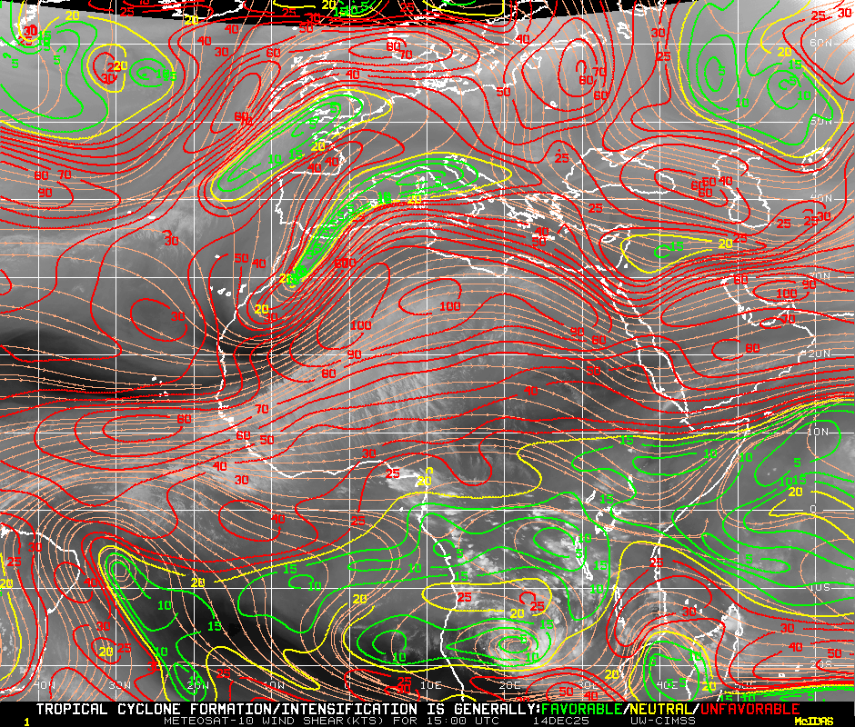
Re: Blob over west Africa (Pouch 15L)
Very large anti-cyclone from the CV Islands well into Mali.
http://tropic.ssec.wisc.edu/real-time/e ... wm7shr.GIF
Excellent UL environment not to mention low SAL
http://tropic.ssec.wisc.edu/real-time/sal/splitE.jpg
http://tropic.ssec.wisc.edu/real-time/e ... wm7shr.GIF
Excellent UL environment not to mention low SAL
http://tropic.ssec.wisc.edu/real-time/sal/splitE.jpg
0 likes
-
Aric Dunn
- Category 5
- Posts: 21238
- Age: 43
- Joined: Sun Sep 19, 2004 9:58 pm
- Location: Ready for the Chase.
- Contact:
well poof goes the convection over night. looks like environmental conditions not so great atm maybe a couple days.
0 likes
Note: If I make a post that is brief. Please refer back to previous posts for the analysis or reasoning. I do not re-write/qoute what my initial post said each time.
If there is nothing before... then just ask
Space & Atmospheric Physicist, Embry-Riddle Aeronautical University,
I believe the sky is falling...
If there is nothing before... then just ask
Space & Atmospheric Physicist, Embry-Riddle Aeronautical University,
I believe the sky is falling...
-
cycloneye
- Admin
- Posts: 149511
- Age: 69
- Joined: Thu Oct 10, 2002 10:54 am
- Location: San Juan, Puerto Rico
Re: Big wave emerging West Africa (Pouch 15L)
This morning's discussion about this wave by Dr Jeff Masters.
A large tropical wave is emerging from the coast of Africa today, and the GFS and ECMWF models predict this wave will develop into a tropical depression 4 - 5 days from now. Preliminary indications are that this new storm will follow a path similar to Gordon's, recurving to the east of Bermuda, but it is too early to be confident of this.
A large tropical wave is emerging from the coast of Africa today, and the GFS and ECMWF models predict this wave will develop into a tropical depression 4 - 5 days from now. Preliminary indications are that this new storm will follow a path similar to Gordon's, recurving to the east of Bermuda, but it is too early to be confident of this.
0 likes
Visit the Caribbean-Central America Weather Thread where you can find at first post web cams,radars
and observations from Caribbean basin members Click Here
and observations from Caribbean basin members Click Here
-
cycloneye
- Admin
- Posts: 149511
- Age: 69
- Joined: Thu Oct 10, 2002 10:54 am
- Location: San Juan, Puerto Rico
Re: Big wave emerging West Africa (Pouch 15L)
This is this mornings analysis of this pouch that I found interesting.
P15L
13N, 7W
700 hPa
All models analyze an initial circulation that is oriented SW-NE over west Africa with an OW max on the SW end and another at the NE end. However, the models handle the situation quite differently. ECMWF & GFS tend to merge these features into a single, westward-moving pouch. UKMET and NOGAPS forecast the northeastern portion of the wave/pouch to be stronger and eventually emerge off of Africa, but slower and later than in ECMWF and GFS. In the meantime, UKMET and NOGAPS spin up an additional circulation to the west in the ITCZ/MT. Is the southwestern portion of the initial circulation playing some sort of role with the spin up of this additional circulation?
ECMWF: As it often does, ECMWF depicts yet another OW max in the center in the elongated initial circulation, which is what I use at that time for the position. The OW maxima merge as they become more S-N oriented over the African coast. The resultant single-OW max pouch then moves relatively straight westward over the eastern Atlantic, intensifying gradually and steadily.
GFS: Similar to ECMWF, with the southwestern OW max stronger during the first couple days.
UKMET: Initial position is between the two OW maxima, and then UKMET strengthens the northeastern portion. That pouch eventually moves off of Africa, faster than NOGAPS but still east of ECMWF and GFS. Like NOGAPS, UKMET then develops a very strong additional pouch in the ITCZ/MT west/ahead to P15L, between P15L and P14L.
NOGAPS: Initial position is between the two OW maxima, and then NOGAPS, like UKMET, definitely favors the northeastern portion, almost dissipating the southwestern OW max by 12 hours. That results in a position that is farther east than in ECMWF & GFS. Then P15L moves slowly westward. Like UKMET, NOGAPS then develops a new circulation in the ITCZ/MT to the west/ahead of P15L.
HWRF-GEN:
ECMWF -8.8 v700 120h
GFS -8.4 v700 120h
UKMET -6.1 v700 120h
NOGAPS -5.9 v700 120h
http://www.met.nps.edu/~mtmontgo/storms2012/P15L.html
0 likes
Visit the Caribbean-Central America Weather Thread where you can find at first post web cams,radars
and observations from Caribbean basin members Click Here
and observations from Caribbean basin members Click Here
-
wxman57

- Moderator-Pro Met

- Posts: 23175
- Age: 68
- Joined: Sat Jun 21, 2003 8:06 pm
- Location: Houston, TX (southwest)
Re: Big wave emerging West Africa (Pouch 15L)
Weak ridging north of the MDR should allow for recurvature of any developing system east of the Caribbean over the next week or two. This season is playing out as some had suspected - unfavorable conditions in the MDR, where tropical systems continue to struggle (Earl, Florence, Seven). Have to keep an eye on the western Caribbean and Gulf for close-in development over the coming weeks.
0 likes
-
cycloneye
- Admin
- Posts: 149511
- Age: 69
- Joined: Thu Oct 10, 2002 10:54 am
- Location: San Juan, Puerto Rico
Re: Big wave emerging West Africa (Pouch 15L)
Saved image at 15:30 UTC.

0 likes
Visit the Caribbean-Central America Weather Thread where you can find at first post web cams,radars
and observations from Caribbean basin members Click Here
and observations from Caribbean basin members Click Here
-
Aric Dunn
- Category 5
- Posts: 21238
- Age: 43
- Joined: Sun Sep 19, 2004 9:58 pm
- Location: Ready for the Chase.
- Contact:
GFS is much stronger on the 12z run today and quicker to develop. Has decent TS in 72 to 90 hours.
0 likes
Note: If I make a post that is brief. Please refer back to previous posts for the analysis or reasoning. I do not re-write/qoute what my initial post said each time.
If there is nothing before... then just ask
Space & Atmospheric Physicist, Embry-Riddle Aeronautical University,
I believe the sky is falling...
If there is nothing before... then just ask
Space & Atmospheric Physicist, Embry-Riddle Aeronautical University,
I believe the sky is falling...
-
cycloneye
- Admin
- Posts: 149511
- Age: 69
- Joined: Thu Oct 10, 2002 10:54 am
- Location: San Juan, Puerto Rico
Re: Big wave emerging West Africa (Pouch 15L)
120 hours.

0 likes
Visit the Caribbean-Central America Weather Thread where you can find at first post web cams,radars
and observations from Caribbean basin members Click Here
and observations from Caribbean basin members Click Here
-
Aric Dunn
- Category 5
- Posts: 21238
- Age: 43
- Joined: Sun Sep 19, 2004 9:58 pm
- Location: Ready for the Chase.
- Contact:
Re: Big wave emerging West Africa (Pouch 15L)
cycloneye wrote:120 hours.
[img]http://oi46.tinypic.com/2db6mau.jpg[/ig]
Notice the strong ridging in place through the western atlantic.
0 likes
Note: If I make a post that is brief. Please refer back to previous posts for the analysis or reasoning. I do not re-write/qoute what my initial post said each time.
If there is nothing before... then just ask
Space & Atmospheric Physicist, Embry-Riddle Aeronautical University,
I believe the sky is falling...
If there is nothing before... then just ask
Space & Atmospheric Physicist, Embry-Riddle Aeronautical University,
I believe the sky is falling...
-
cycloneye
- Admin
- Posts: 149511
- Age: 69
- Joined: Thu Oct 10, 2002 10:54 am
- Location: San Juan, Puerto Rico
Re: Big wave emerging West Africa (Pouch 15L)
At 144 hours.

0 likes
Visit the Caribbean-Central America Weather Thread where you can find at first post web cams,radars
and observations from Caribbean basin members Click Here
and observations from Caribbean basin members Click Here
-
Aric Dunn
- Category 5
- Posts: 21238
- Age: 43
- Joined: Sun Sep 19, 2004 9:58 pm
- Location: Ready for the Chase.
- Contact:
ridging breaks down and NW turn starts its very similar to the 00z euro now.
still too early to tell exactly but the timing will be key both models build a strong back just after the system moves n. if its slower to develop then no recurve is possible. we just a a couple weeks to wait lol
still too early to tell exactly but the timing will be key both models build a strong back just after the system moves n. if its slower to develop then no recurve is possible. we just a a couple weeks to wait lol
0 likes
Note: If I make a post that is brief. Please refer back to previous posts for the analysis or reasoning. I do not re-write/qoute what my initial post said each time.
If there is nothing before... then just ask
Space & Atmospheric Physicist, Embry-Riddle Aeronautical University,
I believe the sky is falling...
If there is nothing before... then just ask
Space & Atmospheric Physicist, Embry-Riddle Aeronautical University,
I believe the sky is falling...
-
cycloneye
- Admin
- Posts: 149511
- Age: 69
- Joined: Thu Oct 10, 2002 10:54 am
- Location: San Juan, Puerto Rico
Re: Big wave emerging West Africa (Pouch 15L)
Invest 94L will be up in the next couple of days or sooner?
0 likes
Visit the Caribbean-Central America Weather Thread where you can find at first post web cams,radars
and observations from Caribbean basin members Click Here
and observations from Caribbean basin members Click Here
Who is online
Users browsing this forum: chaser1, Kingarabian and 374 guests