Texas Summer 2012

U.S. & Caribbean Weather Discussions and Severe Weather Events

Moderator: S2k Moderators

Forum rules

The posts in this forum are NOT official forecast and should not be used as such. They are just the opinion of the poster and may or may not be backed by sound meteorological data. They are NOT endorsed by any professional institution or STORM2K.

Help Support Storm2K
Message
Author
User avatar
Rgv20
S2K Supporter
S2K Supporter
Posts: 2466
Age: 38
Joined: Wed Jan 05, 2011 5:42 pm
Location: Edinburg/McAllen Tx

#461 Postby Rgv20 » Tue Aug 14, 2012 11:36 pm

Well tonight's 0zGFS still insists on developing a TC in the Western GOM, Time frame of development looks like Sunday according to the GFS. The alarming part of the GFS forecast is that it is in no hurry with this possible disturbance as it takes 2 days to move 150 miles give or take! Still plenty of time to watch how this all unfolds but this could potentially bring some very very heavy rain to South Texas early next week.


Sunday Night
Image

Wednesday Morning
Image
0 likes   
The following post is NOT an official forecast and should not be used as such. It is just the opinion of the poster and may or may not be backed by sound meteorological data. It is NOT endorsed by any professional institution including storm2k.org For Official Information please refer to the NHC and NWS products.

User avatar
Rgv20
S2K Supporter
S2K Supporter
Posts: 2466
Age: 38
Joined: Wed Jan 05, 2011 5:42 pm
Location: Edinburg/McAllen Tx

#462 Postby Rgv20 » Tue Aug 14, 2012 11:46 pm

Tonight's 0zGFS forecast Rainfall for days 6-10.. :eek:

Image
0 likes   
The following post is NOT an official forecast and should not be used as such. It is just the opinion of the poster and may or may not be backed by sound meteorological data. It is NOT endorsed by any professional institution including storm2k.org For Official Information please refer to the NHC and NWS products.

User avatar
somethingfunny
ChatStaff
ChatStaff
Posts: 3926
Age: 36
Joined: Thu May 31, 2007 10:30 pm
Location: McKinney, Texas

Re: Texas Summer 2012

#463 Postby somethingfunny » Wed Aug 15, 2012 1:18 am

Well this is neat.

Image
0 likes   
I am not a meteorologist, and any posts made by me are not official forecasts or to be interpreted as being intelligent. These posts are just my opinions and are probably silly opinions.

User avatar
somethingfunny
ChatStaff
ChatStaff
Posts: 3926
Age: 36
Joined: Thu May 31, 2007 10:30 pm
Location: McKinney, Texas

Re: Texas Summer 2012

#464 Postby somethingfunny » Wed Aug 15, 2012 1:48 am

And this is really neat...

Image
0 likes   
I am not a meteorologist, and any posts made by me are not official forecasts or to be interpreted as being intelligent. These posts are just my opinions and are probably silly opinions.

User avatar
Ntxw
Storm2k Moderator
Storm2k Moderator
Posts: 22731
Joined: Wed Oct 21, 2009 6:34 pm
Location: DFW, Texas

#465 Postby Ntxw » Wed Aug 15, 2012 2:19 am

Amazing what the low level jet can do. Very strange for mid August, refreshing at the least. Love it, lots of 2-4+ inch rain areas in north Tx.
0 likes   
The above post and any post by Ntxw is NOT an official forecast and should not be used as such. It is just the opinion of the poster and may or may not be backed by sound meteorological data. It is NOT endorsed by any professional institution including Storm2k. For official information, please refer to NWS products.

  Help support Storm2K!
Help Support Storm2K

User avatar
somethingfunny
ChatStaff
ChatStaff
Posts: 3926
Age: 36
Joined: Thu May 31, 2007 10:30 pm
Location: McKinney, Texas

Re: Texas Summer 2012

#466 Postby somethingfunny » Wed Aug 15, 2012 2:25 am

It looks like a mesoscale low is forming over Lewisville, if you watch the radar and see how the band of heavy rainfall anchors itself at its' northern end and begins swinging outwards.

Image

I'm starting to get worried it's going to swing right past me to my north like a pendulum. :x

But with hours of slow soaking light rain tonight, I really can't complain about anything! :D
0 likes   
I am not a meteorologist, and any posts made by me are not official forecasts or to be interpreted as being intelligent. These posts are just my opinions and are probably silly opinions.

User avatar
somethingfunny
ChatStaff
ChatStaff
Posts: 3926
Age: 36
Joined: Thu May 31, 2007 10:30 pm
Location: McKinney, Texas

Re: Texas Summer 2012

#467 Postby somethingfunny » Wed Aug 15, 2012 3:09 am

First band poofed out and missed me to the north like I was afraid it would.

A new band popped up and definitely will not miss me.

Image
0 likes   
I am not a meteorologist, and any posts made by me are not official forecasts or to be interpreted as being intelligent. These posts are just my opinions and are probably silly opinions.

User avatar
Portastorm
Storm2k Moderator
Storm2k Moderator
Posts: 9914
Age: 62
Joined: Fri Jul 11, 2003 9:16 am
Location: Round Rock, TX
Contact:

Re: Texas Summer 2012

#468 Postby Portastorm » Wed Aug 15, 2012 7:18 am

Happy this morning to see that our friends in north Texas are getting rained on. Good luck to y'all!

For those of us south of Waco, later this weekend into next week looks like it could be "our time" based on the 0z Euro and GFS and morning discussions out of Texas NWSFOs. The Euro plows an unseasonably cool August front into the northern Gulf. The GFS stalls the front further north in Texas but develops a tropical system in the Western Gulf and slowly creeps it up the east coast of mainland Mexico to just south of Brownsville. Both options show ample rainfall for south Texas, so "pick your poison!"

As much I have heralded King Euro over the years, I gotta admit that the GFS has impressed me this summer. I wouldn't bet against it.
0 likes   
Any forecasts under my name are to be taken with a grain of salt. Get your best forecasts from the National Weather Service and National Hurricane Center.

weatherdude1108
Category 5
Category 5
Posts: 4228
Joined: Tue Dec 13, 2011 1:04 pm
Location: Northwest Austin/Cedar Park, TX

#469 Postby weatherdude1108 » Wed Aug 15, 2012 8:40 am

:uarrow:
GREAT NEWS all around!! :D
0 likes   

User avatar
Rgv20
S2K Supporter
S2K Supporter
Posts: 2466
Age: 38
Joined: Wed Jan 05, 2011 5:42 pm
Location: Edinburg/McAllen Tx

#470 Postby Rgv20 » Wed Aug 15, 2012 3:18 pm

HPC afternoon discussion.

FINAL...

WITH THE EXCEPTION OF ADDING A SPOT LOW APPROACHING
BROWNSVILLE...TEXAS...DAYS 6 AND 7...AS PER COORDINATION WITH THE
NATIONAL HURRICANE CENTER...MADE ONLY COSMETIC CHANGES TO THE
UPDATE PACKAGE FOR THE FINAL ISSUANCE. THE LOW ALONG THE GULF
COAST OF MEXICO IS INTENDED TO REFLECT THE POSSIBILITY OF TROPICAL
DEVELOPMENT...BUT IN THE MOST PRACTICAL SENSE...ADDS SUPPORT FOR
INCREASING THE PROBABILITY OF PRECIPITATION OVER THE REGION IN THE
MOIST FLOW NEAR THE SOUTHERN EDGE OF THE WESTERLIES.
0 likes   
The following post is NOT an official forecast and should not be used as such. It is just the opinion of the poster and may or may not be backed by sound meteorological data. It is NOT endorsed by any professional institution including storm2k.org For Official Information please refer to the NHC and NWS products.

User avatar
Rgv20
S2K Supporter
S2K Supporter
Posts: 2466
Age: 38
Joined: Wed Jan 05, 2011 5:42 pm
Location: Edinburg/McAllen Tx

#471 Postby Rgv20 » Wed Aug 15, 2012 11:36 pm

0zGFS continues to hint at a possible TC developing in the Western GOM albeit in this run it keeps most of the energy inland on the Mexican Coast. The difference between the GFS and ECMWF is how they handle the 850mb Vorticity currently in the Gulf Of Honduras.....GFS has been keeping the energy long enough over water where it would have a chance to develop and in contrast the ECMWF keeps moving the Vorticity WNW toward the Mexican Coast. FWIW the 12zECMWF run was about 12 hours slower with the vorticity than the previous 0z run.

Image
0 likes   
The following post is NOT an official forecast and should not be used as such. It is just the opinion of the poster and may or may not be backed by sound meteorological data. It is NOT endorsed by any professional institution including storm2k.org For Official Information please refer to the NHC and NWS products.

User avatar
Rgv20
S2K Supporter
S2K Supporter
Posts: 2466
Age: 38
Joined: Wed Jan 05, 2011 5:42 pm
Location: Edinburg/McAllen Tx

#472 Postby Rgv20 » Thu Aug 16, 2012 12:10 am

0zGFS Ensemble Means keep the Low a little further offshore than the Operational Run.....Regardless of development it looks like some wet weather for is on tap for South Texas :D


0zGFS Ensemble Means forecast valid for Monday Evening..
Image
0 likes   
The following post is NOT an official forecast and should not be used as such. It is just the opinion of the poster and may or may not be backed by sound meteorological data. It is NOT endorsed by any professional institution including storm2k.org For Official Information please refer to the NHC and NWS products.

User avatar
Rgv20
S2K Supporter
S2K Supporter
Posts: 2466
Age: 38
Joined: Wed Jan 05, 2011 5:42 pm
Location: Edinburg/McAllen Tx

#473 Postby Rgv20 » Thu Aug 16, 2012 7:37 am

NWS Brownsville Early Morning Discussion..

"LONG TERM /FRIDAY NIGHT THROUGH WEDNESDAY/...WEATHER SCENARIO FOR
THE LONG TERM PORTION OF THE FORECAST BECOMING A LITTLE MORE CLEAR
NOW. GFS...EUROPEAN...AND CANADIAN MODEL GUIDANCE ALL SUGGEST THAT
A TROPICAL DISTURBANCE WILL DEVELOP ALONG THE EAST COAST OF MEXICO
EARLY TO MIDDLE OF NEXT WEEK...AND POSSIBLY AFFECT THE LOWER TEXAS
COAST.
WITH DEEP TROPICAL MOISTURE INCREASING WITHIN DEEP SOUTH
TEXAS AND THE RIO GRANDE VALLEY IN ADVANCE AND IN ASSOCIATION WITH
THE POTENTIAL DISTURBANCE...AND MID-LEVEL HIGH PRESSURE REMAINING
CENTERED OVER THE DESERT SOUTHWEST...ISOLATED TO SCATTERED SHOWERS
AND THUNDERSTORMS ARE ANTICIPATED FOR MUCH OF THE PERIOD WITHIN
THE BRO CWFA. TEMPERATURES WILL BE KNOCKED DOWN TO MORE NEAR
NORMAL LEVELS DUE TO THE INCREASED CLOUD COVER AND OPPORTUNITIES
FOR PRECIPITATION."
0 likes   
The following post is NOT an official forecast and should not be used as such. It is just the opinion of the poster and may or may not be backed by sound meteorological data. It is NOT endorsed by any professional institution including storm2k.org For Official Information please refer to the NHC and NWS products.

User avatar
Rgv20
S2K Supporter
S2K Supporter
Posts: 2466
Age: 38
Joined: Wed Jan 05, 2011 5:42 pm
Location: Edinburg/McAllen Tx

#474 Postby Rgv20 » Thu Aug 16, 2012 11:31 am

Pretty good info from the HPC Morning Discussion..


PRELIMINARY UPDATE...

USED THE 00Z/16 DETERMINISTIC ECMWF TO UPDATE THE PRELIMINARY
FRONTS AND PRESSURES FOR DAYS 3 THROUGH 7. THE ECMWF IS STRONGLY
CORRELATED WITH THE 00Z/16 ECENS MEAN...GEFS MEAN...AND
DETERMINISTIC GEM GLOBAL THROUGH THE PERIOD. THE 00Z/16 GFS IS OUT
OF SYNC WITH THE OTHER GUIDANCE LATE IN THE PERIOD...SHOWING ITS
BIAS OF WARMING TOO QUICKLY AND TOO SHARPLY IN THE WAKE OF THE
EASTERN TROUGH. SOUTH TEXAS CONTINUES TO BE AN AREA OF INTEREST
FOR POTENTIALLY HEAVY RAINFALL. WHETHER AN ORGANIZED TROPICAL
CYCLONE IS ABLE TO FORM OVER THE FAR WESTERN GULF OF MEXICO MAY BE
IMMATERIAL TO THE RAINFALL THREAT...WITH THE MOIST PLUME FROM THE
SOUTH INTERSECTING THE SOUTHERN EDGE OF THE WESTERLIES OVER THE
REGION.
THE BIGGEST SENSIBLE WEATHER UPSHOT OF USING THE ECMWF
VERSUS THE GFS OVER THE NORTH CENTRAL STATES IS THE TENACITY OF
COOLER AIR TO THE EAST...WITH AN ENHANCEMENT TO THE BAROCLINICITY
VIA OVERRUNNING PRECIPITATION.
0 likes   
The following post is NOT an official forecast and should not be used as such. It is just the opinion of the poster and may or may not be backed by sound meteorological data. It is NOT endorsed by any professional institution including storm2k.org For Official Information please refer to the NHC and NWS products.

User avatar
Rgv20
S2K Supporter
S2K Supporter
Posts: 2466
Age: 38
Joined: Wed Jan 05, 2011 5:42 pm
Location: Edinburg/McAllen Tx

#475 Postby Rgv20 » Thu Aug 16, 2012 2:58 pm

NWS in Brownsville being pretty aggressive with rain chances early next week.. :D

".LONG TERM /SATURDAY THROUGH WEDNESDAY NIGHT/...A LOW PRESSURE
TROUGH NOW EMERGING INTO THE BAY OF CAMPECHE WILL MAINTAIN SOME
COHERENCE AS IT MOVES WNW TO NW...THOUGH IT IS CURRENTLY NOT
EXPECTED TO DEVELOP MUCH FURTHER TROPICAL CYCLONE WISE. ALONG WITH
MID LEVEL WEAKNESS OVER THE WEST GULF HOWEVER...AND PLENTIFUL
MOISTURE INFLUX...DEEP SOUTH TEXAS AND THE LOWER RIO GRANDE WILL
BE IN FOR A TURN TO THE WET SIDE BEGINNING ABOUT SUNDAY. WITH THE
GFS AS A BASE...BLENDED POPS WITH THE RAMP UP OCCURRING SATURDAY
AND SATURDAY NIGHT. WILL GO FROM ISOLATED TO A MINIMUM OF
SCATTERED OR MORE SUNDAY THROUGH THE END OF THE FORECAST. CUTTING
LOOSE WITH MORE ROBUST POPS IN THE LONG TERM WAS THE BIGGEST
CHANGE FROM THE INHERITED FORECAST. THE SIGNAL FOR INCREASED POPS
IS PRETTY SOLID FOR THE MARINE AND COASTAL AREAS...WHILE INLAND
AREAS MAY SEE PERIODS OF LESSER RAINFALL. NONETHELESS...WITH HEAVY
RAINFALL POSSIBLE AND THE LOW PRESSURE AREA HUGGING THE NORTHEAST
MEXICAN COAST OR MOVING SLIGHTLY INLAND...LAND AREAS HAVE THE
POTENTIAL TO RECEIVE MUCH MORE RAIN THAN THE MARINE AREAS.
ACCUMULATIONS OF 2 TO 3 INCHES FOR PORTIONS OF THE LOWER VALLEY
THROUGH TUESDAY MORNING WILL BE POSSIBLE."
0 likes   
The following post is NOT an official forecast and should not be used as such. It is just the opinion of the poster and may or may not be backed by sound meteorological data. It is NOT endorsed by any professional institution including storm2k.org For Official Information please refer to the NHC and NWS products.

weatherdude1108
Category 5
Category 5
Posts: 4228
Joined: Tue Dec 13, 2011 1:04 pm
Location: Northwest Austin/Cedar Park, TX

#476 Postby weatherdude1108 » Thu Aug 16, 2012 4:20 pm

Keeping the glass half-full, I guess "spotty" is better than none.

I do like the mention of "like an early fall pattern." :wink:

AREA FORECAST DISCUSSION
NATIONAL WEATHER SERVICE AUSTIN/SAN ANTONIO TX
349 PM CDT THU AUG 16 2012

.DISCUSSION...
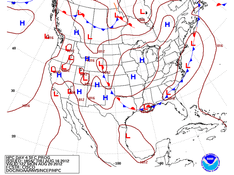
FAIRLY BENIGN CONDITIONS ACROSS SOUTH CENTRAL TEXAS THIS
AFTERNOON. THE MAIN FORECAST ISSUE IS THE AMOUNT OF MOIST GULF AIR
AND FORCING MECHANISMS FOR LIFT THAT WILL BE OVER THE AREA DURING
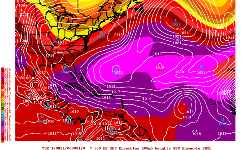
THE NEXT WEEK. 12Z MODEL SOLUTIONS SHOW A LARGE RANGE AMONG EACH
OTHER AND WITH PREVIOUS RUNS...AND EVEN A CONSENSUS FORECAST MAY
NOT BE PARTICULARLY ACCURATE. WE HAVE DECIDED TO STICK NEAR THE
GFS AS THE MOST CONSISTENT WITH TIMING AND STRENGTH OF THE SLUG
OF MOIST AIR THAT WILL MOVE NORTH FROM THE BAY OF CAMPECHE. BUT
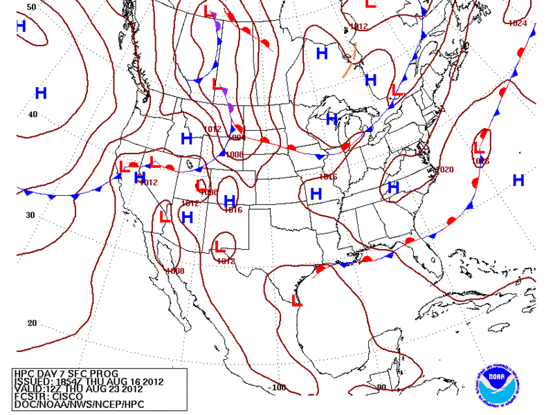
WITH A COL IN THE MID AND UPPER LEVEL FLOW OVER SOUTH TEXAS...THE
MOVEMENT/DEVELOPMENT OF FEATURES IS VERY UNCERTAIN BEYOND SUNDAY.
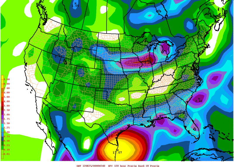
BASED ON CLIMATOLOGY OF SIMILAR EVENTS...THIS IS LIKE AN EARLY
FALL PATTERN...AND THE MOST LIKELY OUTCOME WILL BE SCATTERED
SHOWERS AND THUNDERSTORMS EACH DAY FROM SUNDAY THROUGH NEXT
WEDNESDAY...
THEN TAPERING OFF AT THE END OF NEXT WEEK.
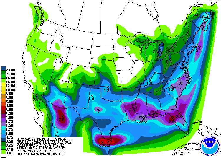
 MOST
LOCATIONS WILL RECEIVE SOME RAIN NEXT WEEK...
BUT AMOUNTS WILL BE
VERY SPOTTY. SOME MAY RECEIVE A COUPLE OF INCHES...OTHERS MAYBE
1/4 INCH OR LESS.
IN GENERAL...RAINFALL WILL BE MOST WIDESPREAD
WITH THE HEAVIEST AMOUNTS ALONG AND EAST OF I-35...TAPERING OFF IN
COVERAGE AND AMOUNT TO THE WEST. AFTERNOON HIGH TEMPERATURES WILL
FALL A FEW DEGREES WITH MORE MOIST AIR...CLOUDCOVER...AND
SCATTERED STORMS. MORNING LOW TEMPERATURES WILL REMAIN IN THE 70S.
0 likes   
The preceding post is NOT an official forecast, and should not be used as such. It is only the opinion of the poster and may or may not be backed by sound meteorological data. It is NOT endorsed by any professional institution including storm2k.org. For Official Information please refer to the NHC and NWS products.

User avatar
Ntxw
Storm2k Moderator
Storm2k Moderator
Posts: 22731
Joined: Wed Oct 21, 2009 6:34 pm
Location: DFW, Texas

Re: Texas Summer 2012

#477 Postby Ntxw » Thu Aug 16, 2012 6:17 pm

PNA is about to rise to levels not seen this summer. We would have to look at spring and last winter for such values. Even though CPC currently does not have a wet/cool scenario beyond this week, I believe it is very likely Texas will continue to see storms from fronts or tropical moisture the rest of this month and for sure first half of Sept. We are nearing the fall equinox which teleconnections starts to play a bigger role.

Image
0 likes   
The above post and any post by Ntxw is NOT an official forecast and should not be used as such. It is just the opinion of the poster and may or may not be backed by sound meteorological data. It is NOT endorsed by any professional institution including Storm2k. For official information, please refer to NWS products.


  Help support Storm2K!

Help Support Storm2K


User avatar
Rgv20
S2K Supporter
S2K Supporter
Posts: 2466
Age: 38
Joined: Wed Jan 05, 2011 5:42 pm
Location: Edinburg/McAllen Tx

#478 Postby Rgv20 » Thu Aug 16, 2012 7:38 pm

HPC forecast calls for a very slow moving disturbance....could be an interesting week ahead for the RGV if this forecast verifies.


Monday Morning...Weak Tropical Low in NE Mexico
Image

Thursday Morning...Weak Tropical Low in the Lower Rio Grande Valley
Image


HPC Forecast Rainfall ending on Tuesday Evening.
Image
0 likes   
The following post is NOT an official forecast and should not be used as such. It is just the opinion of the poster and may or may not be backed by sound meteorological data. It is NOT endorsed by any professional institution including storm2k.org For Official Information please refer to the NHC and NWS products.

User avatar
Rgv20
S2K Supporter
S2K Supporter
Posts: 2466
Age: 38
Joined: Wed Jan 05, 2011 5:42 pm
Location: Edinburg/McAllen Tx

#479 Postby Rgv20 » Thu Aug 16, 2012 11:35 pm

GFS has been rather consistent on Sunday being the day where ExTd7 gets a chance to come back to life and then drift very slowly north for the next 3 days.. :eek:

0zGFS forecast for Sunday Morning
Image


0zGFS forecast for Wednesday Morning
Image
0 likes   
The following post is NOT an official forecast and should not be used as such. It is just the opinion of the poster and may or may not be backed by sound meteorological data. It is NOT endorsed by any professional institution including storm2k.org For Official Information please refer to the NHC and NWS products.

User avatar
somethingfunny
ChatStaff
ChatStaff
Posts: 3926
Age: 36
Joined: Thu May 31, 2007 10:30 pm
Location: McKinney, Texas

#480 Postby somethingfunny » Fri Aug 17, 2012 12:16 am

I think if anything does form and affect Texas out of this tropical system, it's more likely to be a big messy commahead type of rainmaking tropical storm. We'll see though - it's got plenty of time to figure out what it wants to turn into.
0 likes   
I am not a meteorologist, and any posts made by me are not official forecasts or to be interpreted as being intelligent. These posts are just my opinions and are probably silly opinions.


Return to “USA & Caribbean Weather”

Who is online

Users browsing this forum: No registered users and 49 guests