
ATL: ISAAC - Models
Moderator: S2k Moderators
Re: ATL: INVEST 94L - Models
Plot showing several different model runs...most recent are 1200z....lots of possibilities...several more days of watching and seeing for the Islands...beyond that, no way to know for sure...right now it about trends and consistency of the models more than specific plot points so far out for the islands
0 likes
-
Bocadude85

- Category 5

- Posts: 2991
- Age: 39
- Joined: Mon Apr 18, 2005 2:20 pm
- Location: Honolulu,Hi
Re:
gatorcane wrote:06Z GFS and 00Z ECMWF ensembles in the long-range...the GFS shows a weakness developing east of Florida over the Bahamas but the ECMWF shows more ridging and the weakness further west over Florida and the SE U.S. in this run:


The solution the Euro is showing is a perfect setup for a SE coast landfall
0 likes
-
Stormlover2012
- Category 1

- Posts: 262
- Joined: Sat Jun 23, 2012 11:03 am
-
Blown Away

- S2K Supporter

- Posts: 10253
- Joined: Wed May 26, 2004 6:17 am
Re: ATL: INVEST 94L - Models

240 Hours out, ECMWF has ridge setup that does not appear to allow recurve.
0 likes
Hurricane Eye Experience: David 79, Irene 99, Frances 04, Jeanne 04, Wilma 05… Hurricane Brush Experience: Andrew 92, Erin 95, Floyd 99, Matthew 16, Irma 17, Ian 22, Nicole 22…

Re: ATL: INVEST 94L - Models
I wouldnt get too wrapped up in the 06Z GFS....I would be watching for the 12Z here in a few as well as the EURO in a few hours.....
BTW- the NOGAPS is still jacked....stregenthens it too fast and plows it into the ridge...ala that expiremental model someone posted earlier....
https://www.fnmoc.navy.mil/wxmap_cgi/cg ... t=Tropical
BTW- the NOGAPS is still jacked....stregenthens it too fast and plows it into the ridge...ala that expiremental model someone posted earlier....
https://www.fnmoc.navy.mil/wxmap_cgi/cg ... t=Tropical
0 likes
Re: ATL: INVEST 94L - Models
06Z for Helene but you can see Issac moving into the islands pretty far south in lat....end frames looks to be pulling up maybe over PR or under...if you extrapolated it out...
http://moe.met.fsu.edu/cgi-bin/hwrftc2. ... =Animation
http://moe.met.fsu.edu/cgi-bin/hwrftc2. ... =Animation
0 likes
Re: ATL: INVEST 94L - Models
Still very early in the game with this invest. As we typically see with Cape Verde systems, initial modeling with eastern Atlantic systems has them out to sea, then as it progresses west the models shift west. This one is interesting since the models are showing a westward shift while it is still in the eastern Atlantic. As Gordon moves east ridging will build in behind. Have a feeling that later in the week, the east coast trough will pull out, allowing western Atlantic ridging to build over "him." Don't think this will move as fast as previous system. usually 18- 20 knots is normal, All speculation at this point, but this certainly could be a long trip across the pond.
This is not a forecast and should not be taken as one - merely thoughts and observations.
This is not a forecast and should not be taken as one - merely thoughts and observations.
0 likes
-
CrazyC83
- Professional-Met

- Posts: 34315
- Joined: Tue Mar 07, 2006 11:57 pm
- Location: Deep South, for the first time!
That ECWMF setup seems to agree with my thinking. IMO, this is going to get trapped in the Caribbean at least to around 80W...maybe all the way to the Yucatan. But what track from there - similar to Ivan? Ike? Dean? Felix?
Personal Forecast Disclaimer:
The posts in this forum are NOT official forecast and should not be used as such. They are just the opinion of the poster and may or may not be backed by sound meteorological data. They are NOT endorsed by any professional institution or storm2k.org. For official information, please refer to the NHC and NWS products.
0 likes
-
SouthDadeFish

- Professional-Met
- Posts: 2835
- Joined: Thu Sep 23, 2010 2:54 pm
- Location: Miami, FL
- Contact:
Re:
CrazyC83 wrote:That ECWMF setup seems to agree with my thinking. IMO, this is going to get trapped in the Caribbean at least to around 80W...maybe all the way to the Yucatan.
Personal Forecast Disclaimer:
The posts in this forum are NOT official forecast and should not be used as such. They are just the opinion of the poster and may or may not be backed by sound meteorological data. They are NOT endorsed by any professional institution or storm2k.org. For official information, please refer to the NHC and NWS products.
but the EURO also had a weak system as well all the way across.....all other intensity guidance shows that this will not be a TW when it approaches the islands....
0 likes
-
CrazyC83
- Professional-Met
- Posts: 34315
- Joined: Tue Mar 07, 2006 11:57 pm
- Location: Deep South, for the first time!
Re: Re:
ROCK wrote:CrazyC83 wrote:That ECWMF setup seems to agree with my thinking. IMO, this is going to get trapped in the Caribbean at least to around 80W...maybe all the way to the Yucatan.
Personal Forecast Disclaimer:
The posts in this forum are NOT official forecast and should not be used as such. They are just the opinion of the poster and may or may not be backed by sound meteorological data. They are NOT endorsed by any professional institution or storm2k.org. For official information, please refer to the NHC and NWS products.
but the EURO also had a weak system as well all the way across.....all other intensity guidance shows that this will not be a TW when it approaches the islands....
Looking at the steering currents, the ridge would knock anything less than a high-end major hurricane below 940mb (at 50-60W) into the Windwards and central Caribbean. From there who knows...
0 likes
-
Blown Away
- S2K Supporter
- Posts: 10253
- Joined: Wed May 26, 2004 6:17 am
Re: ATL: INVEST 94L - Models
Appears 12z GFS appears more north and a bit faster than 06z through 84 hours:
http://raleighwx.americanwx.com/models/ ... SLP084.gif
http://raleighwx.americanwx.com/models/ ... SLP084.gif
0 likes
Hurricane Eye Experience: David 79, Irene 99, Frances 04, Jeanne 04, Wilma 05… Hurricane Brush Experience: Andrew 92, Erin 95, Floyd 99, Matthew 16, Irma 17, Ian 22, Nicole 22…
-
gatorcane

- S2K Supporter
- Posts: 23708
- Age: 48
- Joined: Sun Mar 13, 2005 3:54 pm
- Location: Boca Raton, FL
12Z GFS shows building high pressure over the Eastern half of the United States at 120 hours. Future Isaac is heading west through the Leewards and gaining strength. The good news is that the GFS has lowered its intensity projection into the Leewards compared to yesterday's run bringing it closer to the ECMWF intensity prediction but not nearly as weak.
0 likes

-
Blown Away
- S2K Supporter
- Posts: 10253
- Joined: Wed May 26, 2004 6:17 am
Re: ATL: INVEST 94L - Models
12z GFS ... 114 hours ... About 200 miles W of 06z run
http://raleighwx.americanwx.com/models/ ... cal114.gif
http://raleighwx.americanwx.com/models/ ... cal114.gif
0 likes
Hurricane Eye Experience: David 79, Irene 99, Frances 04, Jeanne 04, Wilma 05… Hurricane Brush Experience: Andrew 92, Erin 95, Floyd 99, Matthew 16, Irma 17, Ian 22, Nicole 22…
-
Weatherfreak000
Re: ATL: INVEST 94L - Models
Wow.....looking at that run it seems it makes it into the Caribbean....
0 likes
-
SouthDadeFish
- Professional-Met
- Posts: 2835
- Joined: Thu Sep 23, 2010 2:54 pm
- Location: Miami, FL
- Contact:
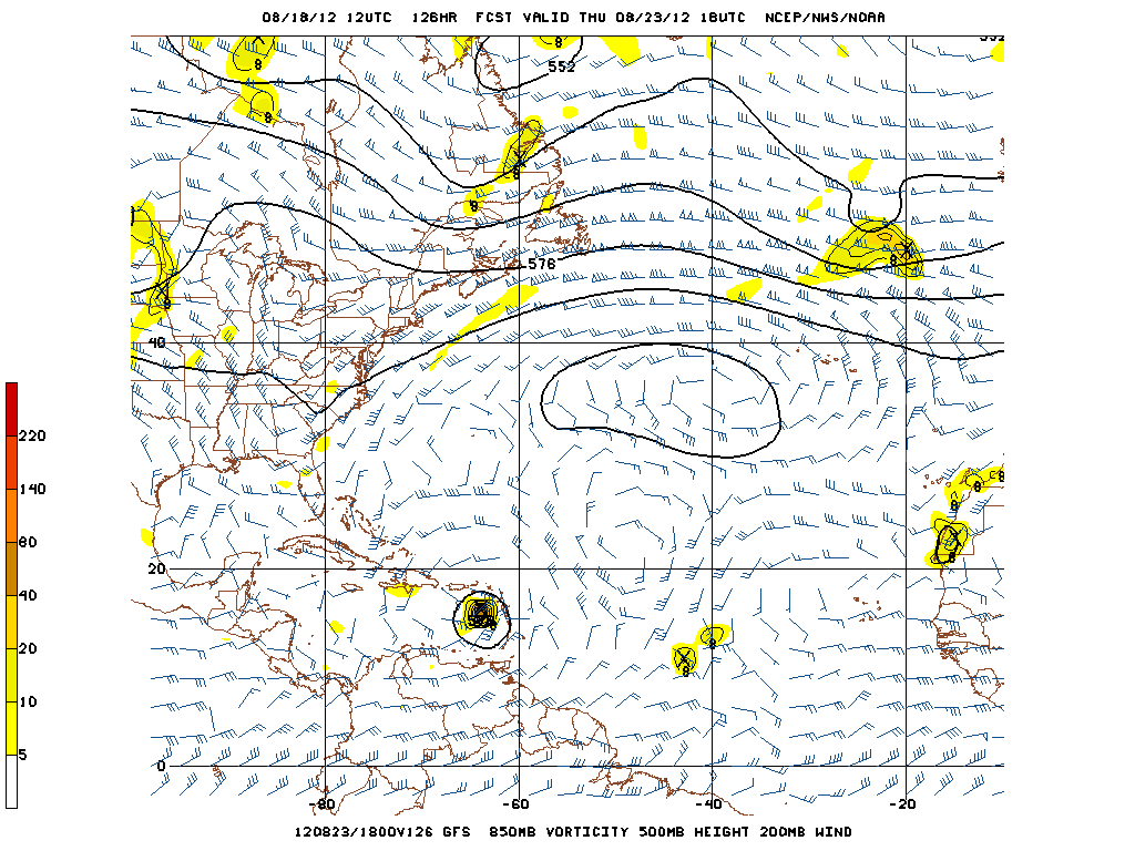
Re:
RL3AO wrote:
126hr.
Nice anti-cyclone over system. Long wave trough over the east coast starting to move out.
That is very scary. What is even more scary is that it is only five days out, which means this scenario is getting more reasonable with with each consecutive model run. The islands have to keep a very close eye on this one.
0 likes
-
Blown Away
- S2K Supporter
- Posts: 10253
- Joined: Wed May 26, 2004 6:17 am
Re: ATL: INVEST 94L - Models
12z GFS ... 150 hours ... Heading for DR and getting stronger
http://raleighwx.americanwx.com/models/ ... cal150.gif
http://raleighwx.americanwx.com/models/ ... cal150.gif
0 likes
Hurricane Eye Experience: David 79, Irene 99, Frances 04, Jeanne 04, Wilma 05… Hurricane Brush Experience: Andrew 92, Erin 95, Floyd 99, Matthew 16, Irma 17, Ian 22, Nicole 22…
-
HurricaneWarning92
- Category 2

- Posts: 520
- Joined: Sat Jul 23, 2011 4:33 pm
- Location: Pembroke Pines, S. Florida (Lat: 26.00N, Lon: 80.22W)
0 likes
The posts in this forum are NOT official forecast and should not be used as such. They are just the opinion of the poster and may or may not be backed by sound meteorological data. They are NOT endorsed by any professional institution or storm2k.org. For official information, please refer to the NHC and NWS products.
Who is online
Users browsing this forum: No registered users and 88 guests