Texas Summer 2012
Moderator: S2k Moderators
Forum rules

The posts in this forum are NOT official forecast and should not be used as such. They are just the opinion of the poster and may or may not be backed by sound meteorological data. They are NOT endorsed by any professional institution or STORM2K.
-
Texas Snowman

- Storm2k Moderator

- Posts: 6197
- Joined: Fri Jan 25, 2008 11:29 am
- Location: Denison, Texas
Re: Texas Summer 2012
Models were right. Hermine is drifting northward in SW Gulf of Mexico.
0 likes
The above post and any post by Texas Snowman is NOT an official forecast and should not be used as such. It is just the opinion of the poster and may or may not be backed by sound meteorological data. It is NOT endorsed by any professional institution including storm2k.org. For official information, please refer to NWS products.
-
Nikki

- S2K Supporter

- Posts: 291
- Joined: Mon Jun 21, 2010 3:38 pm
- Location: Santa Fe, TX (yes I typed that right TEXAS not New Mexico, I am about 20 miles from Galveston, TX)
Re: Texas Summer 2012
Texas Snowman wrote:Models were right. Hermine is drifting northward in SW Gulf of Mexico.
I think you mean, Helene.
0 likes
My name is Nicole and this is what I go by in Storm2k chat! Come chat with us! We have fun in there too!!
A teacher's purpose is not to create students in her own image, but to develop students who can create their own image. ~Author Unknown
Alicia, Allison, Rita, Ike
A teacher's purpose is not to create students in her own image, but to develop students who can create their own image. ~Author Unknown
Alicia, Allison, Rita, Ike
-
Rgv20

- S2K Supporter
- Posts: 2466
- Age: 39
- Joined: Wed Jan 05, 2011 5:42 pm
- Location: Edinburg/McAllen Tx
A couple of days ago it looked like Rainfall totals were going to be much higher.....but when in a drought we take anything we can get!
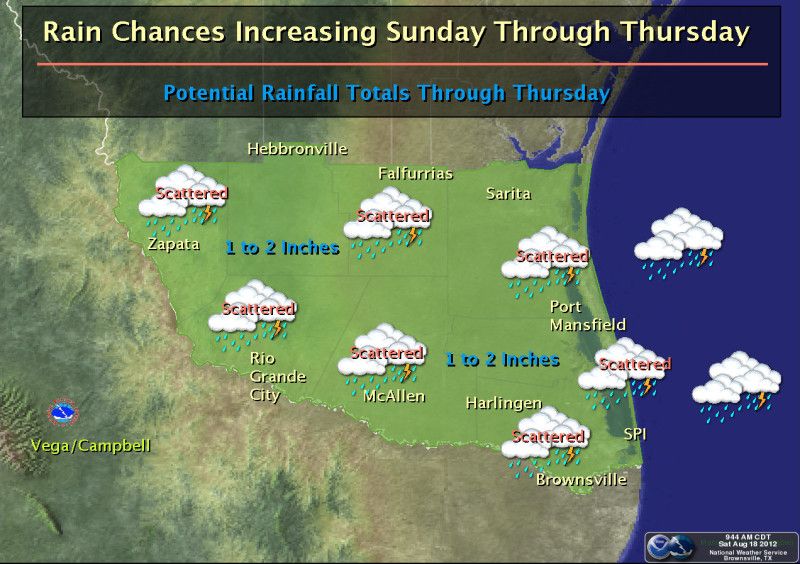
Update...Tropical Storm Helene has made landfall near Tampico, Mexico this morning and has weaken to a Tropical Depression. Forecast models continue to suggest a major change in our weather pattern from Sunday through early next week. Helene will become a remnant low pressure system and track north along the northeast Mexican coast. The approaching low and increasing tropical moisture will combine with an approaching frontal boundary from the north, resulting in scattered showers and thunderstorms Sunday through at least mid week. Latest forecasts suggest portions of Deep South Texas and the RGV could see up to 1 to 2 inches of much needed rainfall. Residents are urged to monitor the latest forecast and statements from the National Weather Service office in Brownsville on this developing weather change. -Vega/Campbell-
Update...Tropical Storm Helene has made landfall near Tampico, Mexico this morning and has weaken to a Tropical Depression. Forecast models continue to suggest a major change in our weather pattern from Sunday through early next week. Helene will become a remnant low pressure system and track north along the northeast Mexican coast. The approaching low and increasing tropical moisture will combine with an approaching frontal boundary from the north, resulting in scattered showers and thunderstorms Sunday through at least mid week. Latest forecasts suggest portions of Deep South Texas and the RGV could see up to 1 to 2 inches of much needed rainfall. Residents are urged to monitor the latest forecast and statements from the National Weather Service office in Brownsville on this developing weather change. -Vega/Campbell-
0 likes
The following post is NOT an official forecast and should not be used as such. It is just the opinion of the poster and may or may not be backed by sound meteorological data. It is NOT endorsed by any professional institution including storm2k.org For Official Information please refer to the NHC and NWS products.
Getting a little thundershower here in Pflugerville, I hope this is just the start. Probably have had no more than a tenth of an inch, haven't checked the rain gauge I just put up because of the lightning.
0 likes
Any opinions stated are those of an amateur, please take with several grains of salt and for official forecast refer to the National Weather Service.
-
weatherdude1108
- Category 5

- Posts: 4228
- Joined: Tue Dec 13, 2011 1:04 pm
- Location: Northwest Austin/Cedar Park, TX
-
weatherdude1108
- Category 5
- Posts: 4228
- Joined: Tue Dec 13, 2011 1:04 pm
- Location: Northwest Austin/Cedar Park, TX

Congrats weatherdude1108 on your rain! Actual front is approaching Red River Valley and won't move through Texas until tonight/tomorrow. Expect more rounds of rain ahead of it and depending where/if it stalls locally could be inches of liquid.

And then 60s early next week for lows even in urban areas! In August!!!
And then 60s early next week for lows even in urban areas! In August!!!
0 likes
The above post and any post by Ntxw is NOT an official forecast and should not be used as such. It is just the opinion of the poster and may or may not be backed by sound meteorological data. It is NOT endorsed by any professional institution including Storm2k. For official information, please refer to NWS products.
Help support Storm2K!
-
Portastorm

- Storm2k Moderator
- Posts: 9955
- Age: 63
- Joined: Fri Jul 11, 2003 9:16 am
- Location: Round Rock, TX
- Contact:
Re:
weatherdude1108 wrote::D
Here at the Weatherdude Center, 1.6 inches late this morning, early afternoon!!
You did a lot better than me. Got about a quarter of an inch here. But it beats nothing. Good for you! Hope we get some more.
0 likes
Any forecasts under my name are to be taken with a grain of salt. Get your best forecasts from the National Weather Service and National Hurricane Center.
-
horselattitudesfarm

- Category 1

- Posts: 315
- Joined: Thu Jul 16, 2009 5:55 pm
- Location: Asheville, NC (formerly from Dallas, TX)
Re: Texas Summer 2012
Getting pounded here in Allen, TX area. 4" and counting since last night. Our little pond behind the house is filling up again  There is even a chilly wind blowing out of the Northeast.
0 likes
-
weatherdude1108
- Category 5
- Posts: 4228
- Joined: Tue Dec 13, 2011 1:04 pm
- Location: Northwest Austin/Cedar Park, TX
If my calculations are correct, isn't one inch in 10 minutes equal to six (6) inches per hour? 
Georgetown is about 30-45 minutes or so from here. Drought to deluge! So far light rain this evening after that heavy stuff earlier today. I'll take rain, but not necessarily an inch in 10 minutes, unless it's directly upstream of the Highland lakes chain!
Flash Flood Warning
FLASH FLOOD WARNING
TXC453-491-190530-
/O.NEW.KEWX.FF.W.0054.120819T0345Z-120819T0530Z/
/00000.0.ER.000000T0000Z.000000T0000Z.000000T0000Z.OO/
BULLETIN - EAS ACTIVATION REQUESTED
FLASH FLOOD WARNING
NATIONAL WEATHER SERVICE AUSTIN/SAN ANTONIO TX
1045 PM CDT SAT AUG 18 2012
THE NATIONAL WEATHER SERVICE IN AUSTIN SAN ANTONIO HAS ISSUED A
* FLASH FLOOD WARNING FOR...
EASTERN TRAVIS COUNTY...
WILLIAMSON COUNTY...
* UNTIL 1230 AM CDT.
* AT 1040 PM CDT...THE PUBLIC REPORTED SLOW MOVING THUNDERSTORMS WITH
VERY HEAVY RAINFALL ACROSS WILLIAMSON AND TRAVIS COUNTIES...
GENERALLY ALONG AND EAST OF INTERSTATE 35. RAINFALL AMOUNTS
OF 1 TO 2 INCHES CAN BE EXPECTED IN A SHORT PERIOD OF TIME.
* RUNOFF FROM THIS EXCESSIVE RAINFALL WILL CAUSE FLASH FLOODING TO
OCCUR. SOME LOCATIONS THAT WILL EXPERIENCE FLOODING INCLUDE...
AUSTIN...AUSTIN BERGSTROM INT AP...GEORGETOWN...GRANGER...
PFLUGERVILLE...ROUND ROCK...SERENADA...TAYLOR...WINDEMERE...
BARTLETT...COUPLAND...GEORGETOWN DAM...GRANGER DAM...HUTTO...
JARRELL...MANOR...ONION CREEK...SUN CITY...THRALL AND WEIR.
OVER ONE INCH OF RAINFALL WAS REPORTED NEAR GEORGETOWN IN AROUND 10 MINUTES.
0 likes
The preceding post is NOT an official forecast, and should not be used as such. It is only the opinion of the poster and may or may not be backed by sound meteorological data. It is NOT endorsed by any professional institution including storm2k.org. For Official Information please refer to the NHC and NWS products.
-
somethingfunny

- ChatStaff

- Posts: 3926
- Age: 37
- Joined: Thu May 31, 2007 10:30 pm
- Location: McKinney, Texas
Re: Texas Summer 2012
Things have taken a confusing turn around the full circle.
"Pray for no rain"
Aerial spraying for the mosquitos that carry the West Nile Virus has been called off Saturday night in Dallas County because of the threat of rain.
Overnight storms also stalled aerial efforts Friday. At one point, Clarke Mosquito Control had 4 planes in the air, but they were grounded around midnight before they could complete their plans.
Crews sprayed roughly 83 thousand acres, but that was only about a quarter of the area that they hoped to cover Friday night.
Laura McGowan of Clarke Mosquito Control says dealing with the weather can be challenging and frustrating but is an expected part of business, "We are going to be at the mercy of the rain, wind… as soon as we have a window, we are going to be up."
Dallas County Judge Clay Jenkins called for help from above.
"I am asking you as your County Judge, the faith-based community," said Jenkins during a noon news conference. "Pray for light winds and no rain, Sunday from 8-30 to 2 o'clock, Monday from 8-30 to 2 o'clock, Tuesday from 8-30 to 2 o'clock."
The recent rain will not lessen the effectiveness of the pesticide that has already been dropped over Dallas County, McGowan said.
County officials are also monitoring for possible side effects in people.
"There have been no spikes of any sort of respiratory illnesses at our hospitals," said Jenkins. "I think if there was going to be a problem to humans, pets, beneficial insects we'd have seen it by now. "We haven't and neither have the other cities that have done this for the last 20 years."
Read more: http://www.myfoxdfw.com/story/19310477/ ... z23xu45ZOr
"Pray for no rain"
0 likes
I am not a meteorologist, and any posts made by me are not official forecasts or to be interpreted as being intelligent. These posts are just my opinions and are probably silly opinions.
-
Terri

- Tropical Low

- Posts: 43
- Joined: Sun Aug 12, 2012 11:54 am
- Location: Williamson County - NW of Georgetown, Tx
Re: Texas Summer 2012
3.67 inches! Williamson County - northwest of Georgetown - rural!!!
0 likes
Terri
Rural Williamson County, Tx
Rural Williamson County, Tx
-
Portastorm
- Storm2k Moderator
- Posts: 9955
- Age: 63
- Joined: Fri Jul 11, 2003 9:16 am
- Location: Round Rock, TX
- Contact:
Re: Texas Summer 2012
Terri wrote:3.67 inches! Williamson County - northwest of Georgetown - rural!!!
First of all, welcome Terri! Good to see you on Storm2K.
Second, congrats on the rainfall. That is a healthy total and I'm sure y'all needed and welcomed every drop.
0 likes
Any forecasts under my name are to be taken with a grain of salt. Get your best forecasts from the National Weather Service and National Hurricane Center.
-
Portastorm
- Storm2k Moderator
- Posts: 9955
- Age: 63
- Joined: Fri Jul 11, 2003 9:16 am
- Location: Round Rock, TX
- Contact:
Re: Texas Summer 2012
Hey Rgv20... very curious AFD out of Brownsville, don't you think? They sort of loosely refer to 95L but no specific mention of it. Considering the potential of it being a major player in your weather, I'm a bit surprised there's not a more specific mention. Interesting.
***********
AREA FORECAST DISCUSSION
NATIONAL WEATHER SERVICE BROWNSVILLE TX
214 PM CDT SUN AUG 19 2012
.SHORT TERM /NOW THROUGH MONDAY NIGHT/...PW SURGED THIS MORNING UP
TO 2.27 INCHES...PRIMING THE AREA FOR SHOWER AND THUNDERSTORM
ACTIVITY. THIS IN RESPONSE TO THE ARRIVAL OF MOISTURE FROM WHAT
WAS HELENE...THE FOCUSING OF THAT MOISTURE AHEAD OF A STALLING
FRONTAL BOUNDARY TO THE NORTH...AND THE STALLED H5 TROUGH
OVERHEAD. CHANCE OF RAIN CONTINUES FOR THE DAY TODAY...WANING
OVERNIGHT FROM LOSS OF HEATING...THEN FURTHER INCREASES TOMORROW
AS THE FRONT STALLS IN DEEP SOUTH TEXAS...PROVIDING AN ADDITIONAL
SFC FOCUS.
&&
.LONG TERM /TUESDAY THROUGH SUNDAY/...THE 500 MB RIDGE WILL REMAIN
POSITIONED TO THE WEST OF DEEP SOUTH TX EARLY IN THE EXTENDED
RANGE PERIOD WHICH WILL ALLOW A BROAD WEAKNESS IN THE RIDGE
POSITION TO LINGER OVER THE AREA. DECENT TROPICAL MOISTURE WILL
ALSO PERSIST WITHIN THE WEAKNESS THROUGH MUCH OF THE UPCOMING WORK
WEEK WHICH WILL MAINTAIN THE THREAT OF SOME CONV EACH DAY. LATER
THIS WEEK THE MEAN RIDGE POSITION SHIFTS BACK TO THE EAST AND
BUILDS STEADILY. THIS STARTS TO DRY OUT AND STABILIZE THE ATMS
OVER SOUTH TX RESULTING IN A RETURN OF SOME WARMER TEMPS AND LOWER
POPS.
BOTH THE GFS AND ECMWF ARE IN PRETTY GOOD AGREEMENT IN THE
HANDLING OF THE OVERALL SYNOPTIC PATTERN IN THE 3 TO 7 DAY RANGE
BOTH WITH THE EXPECTED HEIGHTS AND OVERALL DEEP LAYER MOISTURE
VALUES. RUN TO RUN CONSISTENCY WITH THE GFS MEX TEMPS AND POPS ARE
ALSO PRETTY DECENT. WILL GO CLOSE TO GFS MEX TEMPS AND POPS
THROUGH MID WEEK. WILL GO A LITTLE ABOVE MODEL HIGH TEMPS LATER IN
THE WEEK IN ANTICIPATION OF THE DRYING OUT OF THE ATMS AND
BUILDING MID LEVEL RIDGING. OVERALL CONFIDENCE IN THE LONGER RANGE
PERIOD IS ABOVE AVERAGE.
LOOKING FURTHER EAST INTO THE TROPICAL ATLANTIC...NHC CONTINUES TO
TRACK A TROPICAL WAVE LOCATED ABOUT 950 NM WEST OF THE CAPE VERDE
ISLANDS. THIS FEATURE IS MOVING QUICKLY WEST AT 20 TO 25 MPH.
LONGER RANGE NUMERICAL GUIDANCE TRIES TO PULL THIS FEATURE TO NEAR
CENTRAL CUBA BY NEXT SUNDAY POSSIBLY MOVING INTO THE GULF OF MEX
EARLY NEXT WEEK. BOTH THE GFS AND ECMWF DIFFER GREATLY ON THE
HANDLING OF THIS WAVE WITH THE GFS GOING MUCH MORE AGGRESSIVELY IN
DEVELOPMENT VERSUS THE ECMWF. PLEASE REFER TO THE LATEST
STATEMENTS AND OUTLOOKS FROM NHC CONCERNING THIS FEATURE.
&&
.MARINE...NOW THROUGH MONDAY NIGHT...GENERALLY LIGHTER WINDS WILL
CONTINUE THROUGH TONIGHT...WITH SEAS HOVERING AT 3 TO 4 FEET. SHOWER
AND THUNDERSTORM ACTIVITY WILL CONTINUE...MOVING DUE NORTH
THROUGHOUT. A WEAK EARLY-SEASON FRONT WILL STALL IN THE VICINITY
TOMORROW MORNING...SHIFTING WINDS MORE TO THE EAST BRIEFLY DURING
THE DAY...BEFORE SHIFTING BACK TO THE SOUTHEAST TONIGHT.
TUESDAY THROUGH FRIDAY...BROAD SURFACE RIDGING LOCATED OVER THE
EASTERN PORTION OF THE LOWER 48 STATES WILL MAINTAIN A FAIRLY
LIGHT EASTERLY FLOW ACROSS THE LOWER TX COASTLINE ON TUES. THIS
SURFACE RIDGING WILL THEN SHIFT EAST AS A FRONTAL SYSTEM DIGS INTO
THE CENTRAL PLAINS STATES AROUND MID WEEK. THIS WILL FORCE THE
MARINE FLOW TO SHIFT AROUND TO A MORE S-SE DIRECTION WITH AN
INCREASE IN THE PGF. THIS WILL BUILD THE WINDS AND SEAS LATE IN
THE MARINE FORECAST PERIOD. THESE COULD PUSH INTO SCEC CRITERIA ON
THURS AND FRI.
&&
0 likes
Any forecasts under my name are to be taken with a grain of salt. Get your best forecasts from the National Weather Service and National Hurricane Center.
Re: Texas Summer 2012
It's only August and there's talk of overrunning from FW 
----------------
THE SHORTWAVE TROUGH LOOKS STRONG ENOUGH TO INDUCE RELATIVELY
STRONG MID LEVEL WARM AIR ADVECTION AND ASCENT OVER NORTH TX ON
TUESDAY. ALL GUIDANCE INDICATES THAT A DECENT PLUME OF MID LEVEL
MOISTURE WILL RESIDE OUT AHEAD OF THE TROUGH WHICH SHOULD ALLOW
SCATTERED RAIN SHOWERS TO DEVELOP AS EARLY AS TUESDAY MORNING NEAR
THE RED RIVER. AS SHOWERS MOISTEN UP THE LOWER
LEVELS...EVAPORATIVE COOLING WILL STEEPEN LOW TO MID LEVEL
ISENTROPIC SURFACES WHICH SHOULD PROVIDE THE IMPETUS FOR
ADDITIONAL RAIN SHOWER DEVELOPMENT. THE NAM IS THE STRONGEST WITH
THIS FEEDBACK MECHANISM AND IF IT VERIFIES...POPS WILL LIKELY HAVE
TO BE INCREASED BEFORE TUESDAY AFTERNOON. AT THIS TIME THINK THAT
30 POPS WITH A CHANCE OF RAIN SHOWERS IS SUFFICIENT AS SOME
GUIDANCE INDICATES A MUCH WEAKER SHORTWAVE TROUGH WITH
SIGNIFICANTLY LESS COVERAGE OF RAIN ON TUESDAY.
REGARDLESS...TUESDAY SHOULD BE CLOUDY AND THIS ALONE WILL KEEP
TEMPERATURES SEVERAL DEGREES BELOW NORMAL SO OPTED TO GO WITH
HIGHS IN THE UPPER 80S FOR MOST LOCATIONS AS A RESULT.
FOR THE REST OF THE WEEK...PREVIOUS FORECAST SEEMED TO REMAIN ON
TRACK WITH A MENTION OF A SMALL CHANCE OF STORMS FROM THURSDAY
NIGHT THROUGH FRIDAY NIGHT ACROSS NORTH AND CENTRAL TX. MOISTURE
LOOKS LIKELY TO RETURN TO THE REGION AS SOUTHERLY FLOW RETURNS TO
THE FORECAST AREA MID-WEEK. GUIDANCE REMAINS INCONSISTENT IN THE
HANDLING OF A WEAK DISTURBANCE PROGGED TO AFFECT THE SOUTHERN
PLAINS DURING THIS PERIOD. WHILE WE WILL LIKELY NOT SEE STORMS
DURING THIS ENTIRE PERIOD...THE TIMING WILL BE REFINED IN FUTURE
FORECASTS AS GUIDANCE RESOLVES THIS WEAK UPPER LEVEL ENERGY BETTER
MOVING FORWARD.
CAVANAUGH
----------------
This pretty much wraps it for all of Texas. Seasonal to periods of scattered rain. PNA will rise near 2 standard deviations above normal. May have seen our last 100s northern half of the state, hopefully.
----------------
THE SHORTWAVE TROUGH LOOKS STRONG ENOUGH TO INDUCE RELATIVELY
STRONG MID LEVEL WARM AIR ADVECTION AND ASCENT OVER NORTH TX ON
TUESDAY. ALL GUIDANCE INDICATES THAT A DECENT PLUME OF MID LEVEL
MOISTURE WILL RESIDE OUT AHEAD OF THE TROUGH WHICH SHOULD ALLOW
SCATTERED RAIN SHOWERS TO DEVELOP AS EARLY AS TUESDAY MORNING NEAR
THE RED RIVER. AS SHOWERS MOISTEN UP THE LOWER
LEVELS...EVAPORATIVE COOLING WILL STEEPEN LOW TO MID LEVEL
ISENTROPIC SURFACES WHICH SHOULD PROVIDE THE IMPETUS FOR
ADDITIONAL RAIN SHOWER DEVELOPMENT. THE NAM IS THE STRONGEST WITH
THIS FEEDBACK MECHANISM AND IF IT VERIFIES...POPS WILL LIKELY HAVE
TO BE INCREASED BEFORE TUESDAY AFTERNOON. AT THIS TIME THINK THAT
30 POPS WITH A CHANCE OF RAIN SHOWERS IS SUFFICIENT AS SOME
GUIDANCE INDICATES A MUCH WEAKER SHORTWAVE TROUGH WITH
SIGNIFICANTLY LESS COVERAGE OF RAIN ON TUESDAY.
REGARDLESS...TUESDAY SHOULD BE CLOUDY AND THIS ALONE WILL KEEP
TEMPERATURES SEVERAL DEGREES BELOW NORMAL SO OPTED TO GO WITH
HIGHS IN THE UPPER 80S FOR MOST LOCATIONS AS A RESULT.
FOR THE REST OF THE WEEK...PREVIOUS FORECAST SEEMED TO REMAIN ON
TRACK WITH A MENTION OF A SMALL CHANCE OF STORMS FROM THURSDAY
NIGHT THROUGH FRIDAY NIGHT ACROSS NORTH AND CENTRAL TX. MOISTURE
LOOKS LIKELY TO RETURN TO THE REGION AS SOUTHERLY FLOW RETURNS TO
THE FORECAST AREA MID-WEEK. GUIDANCE REMAINS INCONSISTENT IN THE
HANDLING OF A WEAK DISTURBANCE PROGGED TO AFFECT THE SOUTHERN
PLAINS DURING THIS PERIOD. WHILE WE WILL LIKELY NOT SEE STORMS
DURING THIS ENTIRE PERIOD...THE TIMING WILL BE REFINED IN FUTURE
FORECASTS AS GUIDANCE RESOLVES THIS WEAK UPPER LEVEL ENERGY BETTER
MOVING FORWARD.
CAVANAUGH
----------------
This pretty much wraps it for all of Texas. Seasonal to periods of scattered rain. PNA will rise near 2 standard deviations above normal. May have seen our last 100s northern half of the state, hopefully.
0 likes
The above post and any post by Ntxw is NOT an official forecast and should not be used as such. It is just the opinion of the poster and may or may not be backed by sound meteorological data. It is NOT endorsed by any professional institution including Storm2k. For official information, please refer to NWS products.
Help support Storm2K!
Help support Storm2K!

-
Rgv20
- S2K Supporter
- Posts: 2466
- Age: 39
- Joined: Wed Jan 05, 2011 5:42 pm
- Location: Edinburg/McAllen Tx
Re: Texas Summer 2012
Portastorm wrote:Hey Rgv20... very curious AFD out of Brownsville, don't you think? They sort of loosely refer to 95L but no specific mention of it. Considering the potential of it being a major player in your weather, I'm a bit surprised there's not a more specific mention. Interesting.
Not surprised at all most of the time Brownsville NWS is very very conservative on their wording when it comes to Tropical weather. Monday was looking like the wetter day but now Wednesday might be the day depending on what 95L decides to do.
0 likes
The following post is NOT an official forecast and should not be used as such. It is just the opinion of the poster and may or may not be backed by sound meteorological data. It is NOT endorsed by any professional institution including storm2k.org For Official Information please refer to the NHC and NWS products.
Return to “USA & Caribbean Weather”
Who is online
Users browsing this forum: No registered users and 136 guests