8 PM TWD
A VIGOROUS TROPICAL WAVE IS LOCATED IN THE ERN ATLC ALONG
30W...WITH A ASSOCIATED 1008 MB LOW NEAR 14N30W EMBEDDED WITHIN
THE MONSOON TROUGH. THIS WAVE IS MOVING WESTWARD AROUND 20 KT.
SCATTERED MODERATE TO STRONG CONVECTION IS FROM 14N-17N BETWEEN
30W-33W. CONDITIONS APPEAR CONDUCIVE FOR GRADUAL DEVELOPMENT
DURING THE NEXT FEW DAYS...AND THIS SYSTEM HAS A HIGH CHANCE
OF BECOMING A TROPICAL CYCLONE DURING THE NEXT 48 HOURS. GLOBAL
MODELS HAS A WWD TRAJECTORY TOWARDS THE CARIBBEAN. INTERESTS
ACROSS THE E AND NE CARIBBEAN SHOULD MONITOR THE PROGRESS OF
THIS SYSTEM AS IT TREKS ACROSS THE ATLC.
ATL: ISAAC - Post-Tropical - Discussion
Moderator: S2k Moderators
-
cycloneye

- Admin

- Posts: 149283
- Age: 69
- Joined: Thu Oct 10, 2002 10:54 am
- Location: San Juan, Puerto Rico
Re: ATL: INVEST 94L
0 likes
Visit the Caribbean-Central America Weather Thread where you can find at first post web cams,radars
and observations from Caribbean basin members Click Here
and observations from Caribbean basin members Click Here

SHIPS RI Index at 18z wrote:Prob of RI for 25 kt RI threshold= 40% is 3.1 times the sample mean(12.8%)
Prob of RI for 30 kt RI threshold= 21% is 2.6 times the sample mean( 8.4%)
Prob of RI for 35 kt RI threshold= 11% is 2.3 times the sample mean( 5.0%)
Prob of RI for 40 kt RI threshold= 8% is 2.3 times the sample mean( 3.4%)
The latest. Almost 50/50 for RI.
0 likes
Re: ATL: INVEST 94L
Depends which model and which run of the model - that can vary alot - from the sample of models below, we could see anywhere from an un-named system still to a Cat 3. Sounds about right. Until this develops a defined LLC, the one thing that is less accurate than forecasting track is forecasting intensity.
What we can use as a guide is that the NHC gives it a 60% chance of developing into a tropical cyclone (at least a tropical depression) in the next 48 hours.

What we can use as a guide is that the NHC gives it a 60% chance of developing into a tropical cyclone (at least a tropical depression) in the next 48 hours.
hurricanes1234 wrote:The intensity models are showing this becoming a 115 mph Category 3 in 120 hours, am I right?
_________
The posts in this forum are NOT official forecast and should not be used as such. They are just the opinion of the poster and may or may not be backed by sound meteorological data. They are NOT endorsed by any professional institution or storm2k.org. For official information, please refer to the NHC and NWS products.
0 likes
-
cycloneye
- Admin
- Posts: 149283
- Age: 69
- Joined: Thu Oct 10, 2002 10:54 am
- Location: San Juan, Puerto Rico
Re: ATL: INVEST 94L
00z Best Track
AL, 94, 2012081900, , BEST, 0, 142N, 332W, 30, 1008, DB
ftp://ftp.nhc.noaa.gov/atcf/tcweb/inves ... 012.invest
AL, 94, 2012081900, , BEST, 0, 142N, 332W, 30, 1008, DB
ftp://ftp.nhc.noaa.gov/atcf/tcweb/inves ... 012.invest
0 likes
Visit the Caribbean-Central America Weather Thread where you can find at first post web cams,radars
and observations from Caribbean basin members Click Here
and observations from Caribbean basin members Click Here
-
Hurricaneman

- Category 5

- Posts: 7404
- Age: 45
- Joined: Tue Aug 31, 2004 3:24 pm
- Location: central florida
Re: ATL: INVEST 94L
Those who said the center formed farther north were correct and is now more inline with the convection, its only a matter of time before this is declared, probably some time tomorrow
Personal Forecast Disclaimer:
The posts in this forum are NOT official forecast and should not be used as such. They are just the opinion of the poster and may or may not be backed by sound meteorological data. They are NOT endorsed by any professional institution or storm2k.org. For official information, please refer to the NHC and NWS products.
0 likes


Re:
Cyclenall wrote:SHIPS RI Index at 18z wrote:Prob of RI for 25 kt RI threshold= 40% is 3.1 times the sample mean(12.8%)
Prob of RI for 30 kt RI threshold= 21% is 2.6 times the sample mean( 8.4%)
Prob of RI for 35 kt RI threshold= 11% is 2.3 times the sample mean( 5.0%)
Prob of RI for 40 kt RI threshold= 8% is 2.3 times the sample mean( 3.4%)
The latest. Almost 50/50 for RI.
That's insane. Although, wasn't it pretty high in Ernesto's case for a while there?
I mean...that's crazy.
0 likes
I'm no expert, everything I say should be taken with a large amount of salt. I could easily be very, very wrong.
~Zanthe Go Coyotes~
~Zanthe Go Coyotes~
-
northjaxpro

- S2K Supporter

- Posts: 8900
- Joined: Mon Sep 27, 2010 11:21 am
- Location: Jacksonville, FL
Yes it has Hurricaneman. Earlier this afternoon, Best Track had it positioned at 13.5 N 32.7 W. Now it is 14.2 N Latitude.
The LLC has been repositioned nearly a full degree north.
The LLC has been repositioned nearly a full degree north.
Last edited by northjaxpro on Sat Aug 18, 2012 7:49 pm, edited 1 time in total.
0 likes
NEVER, EVER SAY NEVER in the tropics and weather in general, and most importantly, with life itself!!
________________________________________________________________________________________
Fay 2008 Beryl 2012 Debby 2012 Colin 2016 Hermine 2016 Julia 2016 Matthew 2016 Irma 2017 Dorian 2019
________________________________________________________________________________________
Fay 2008 Beryl 2012 Debby 2012 Colin 2016 Hermine 2016 Julia 2016 Matthew 2016 Irma 2017 Dorian 2019
-
floridasun78
- Category 5
- Posts: 3755
- Joined: Sun May 17, 2009 10:16 pm
- Location: miami fl
Re: ATL: INVEST 94L
it look like going be td very soon time will tell
Personal Forecast Disclaimer:
The posts in this forum are NOT official forecast and should not be used as such. They are just the opinion of the poster and may or may not be backed by sound meteorological data. They are NOT endorsed by any professional institution or storm2k.org. For official information, please refer to the NHC and NWS products
0 likes
-
ozonepete
- Professional-Met

- Posts: 4743
- Joined: Mon Sep 07, 2009 3:23 pm
- Location: From Ozone Park, NYC / Now in Brooklyn, NY
Re: ATL: INVEST 94L
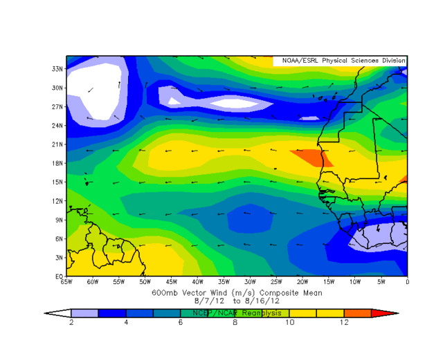
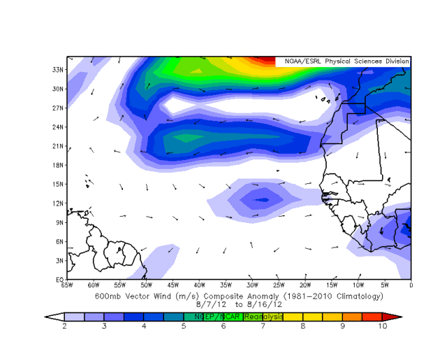
Here's one reason the COC is spinning up so quickly. The MLAEJ (Mid-Level African Easterly Jet) is quite strong and well established right now. The first image shows it's steady westward flow at 600mb (in METERS/SEC). This is very good for carrying and sustaining easterly waves over Africa and then westward into the Atlantic off of Africa. But much more important is how differently it is behaving compared to normal, i.e. the anomalies with it. Note the second image, which is the analysis at 600mb of its variation from normal over the last week, i.e. the anomalies in its strength and direction. Note how it is a little faster than normal right where 94L is and most importantly, note that the wind direction points to the east at 10 degrees, which means that there is a weakness in the westerly component at lower latitudes. What does this all mean? That between about 10 and 15 degrees there is horizontal shear which encourages a twist in the atmosphere. This is allowing a rapid spin-up at mid levels. Combined with such warm SSTs and low vertical wind shear, this one could spin up very quickly.
Last edited by ozonepete on Sat Aug 18, 2012 8:23 pm, edited 2 times in total.
0 likes
-
Aric Dunn
- Category 5
- Posts: 21238
- Age: 43
- Joined: Sun Sep 19, 2004 9:58 pm
- Location: Ready for the Chase.
- Contact:
not sure how to put this. its quite easy to look at past systems as see that this is more organized than most. i agree there is no need to rush the situation... but in terms accuracy. this is already a td quite easily especially if you want to compare to td7 which was sad but had one thing this system does not have.. recon... this looks better than gordon did when it was developing.
0 likes
Note: If I make a post that is brief. Please refer back to previous posts for the analysis or reasoning. I do not re-write/qoute what my initial post said each time.
If there is nothing before... then just ask
Space & Atmospheric Physicist, Embry-Riddle Aeronautical University,
I believe the sky is falling...
If there is nothing before... then just ask
Space & Atmospheric Physicist, Embry-Riddle Aeronautical University,
I believe the sky is falling...
-
floridasun78
- Category 5
- Posts: 3755
- Joined: Sun May 17, 2009 10:16 pm
- Location: miami fl
Re: ATL: INVEST 94L
ozonepete wrote:Here's one reason the COC is spinning up so quickly. The MLAEJ (Mid-Level African Easterly Jet) is quite strong and well established right now. The first image shows it's steady westward flow at 600mb (in METERS/SEC). This is very good for carrying and sustaining easterly waves over Africa and then westward into the Atlantic off of Africa. But much more important is how differently it is behaving compared to normal, i.e. the anomalies with it. Note the second image, which is the analysis at 600mb of its variation from normal over the last week, i.e. the anomalies in its strength and direction. Note how it is a little faster than normal right where 94L is and most importantly, note that the wind direction points to the east at 10 degrees, which means that there is a weakness in the westerly component at lower latitudes. What does this all mean? That between about 10 and 15 degrees there is horizontal shear which encourages a twist in the atmosphere. This is allowing a rapid spin-up at mid levels. Combined with such warm SSTs and low vertical wind shear, this one could spin up very quickly.
i didnt know that ty for explain that i learn something new about tropical system in here every day
0 likes
-
cycloneye
- Admin
- Posts: 149283
- Age: 69
- Joined: Thu Oct 10, 2002 10:54 am
- Location: San Juan, Puerto Rico
Re:
Aric Dunn wrote:not sure how to put this. its quite easy to look at past systems as see that this is more organized than most. i agree there is no need to rush the situation... but in terms accuracy. this is already a td quite easily especially if you want to compare to td7 which was sad but had one thing this system does not have.. recon... this looks better than gordon did when it was developing.
Let's see if an ASCAT pass occurs and captures the center of this.
0 likes
Visit the Caribbean-Central America Weather Thread where you can find at first post web cams,radars
and observations from Caribbean basin members Click Here
and observations from Caribbean basin members Click Here
-
meriland23

- Category 5
- Posts: 1239
- Age: 38
- Joined: Mon Aug 29, 2011 9:29 pm
Curious, so according to latest model runs, it wants to take this into the carribean, which turns it into remenants, but 2 runs ago, up the east coast as a major hurricane. What is it in the carribean that suggests this?
0 likes
The posts in this forum are NOT official forecast and should not be used as such. They are just the opinion of the poster and may or may not be backed by sound meteorological data. They are NOT endorsed by any professional institution or storm2k.org. For official information, please refer to the NHC and NWS products.
-
cycloneye
- Admin
- Posts: 149283
- Age: 69
- Joined: Thu Oct 10, 2002 10:54 am
- Location: San Juan, Puerto Rico
Re: ATL: INVEST 94L
Well Aric,here is a pass made around 7:40 PM EDT,but it missed almost the entire circulation. 

0 likes
Visit the Caribbean-Central America Weather Thread where you can find at first post web cams,radars
and observations from Caribbean basin members Click Here
and observations from Caribbean basin members Click Here
-
ozonepete
- Professional-Met
- Posts: 4743
- Joined: Mon Sep 07, 2009 3:23 pm
- Location: From Ozone Park, NYC / Now in Brooklyn, NY
Re:
meriland23 wrote:Curious, so according to latest model runs, it wants to take this into the carribean, which turns it into remenants, but 2 runs ago, up the east coast as a major hurricane. What is it in the carribean that suggests this?
It's just way to early. The models still don't have a good enough picture of how its doing now, nor what conditions will be like by the time it gets to the Islands. Especially since the cener may be quite a bit north of where it looked like this morning.
0 likes
-
Hurricaneman
- Category 5
- Posts: 7404
- Age: 45
- Joined: Tue Aug 31, 2004 3:24 pm
- Location: central florida
Re: ATL: INVEST 94L
From what I can see, the MLC and LLCC are seperated, LLCC to the south MLC to the north according to ASCAT
Personal Forecast Disclaimer:
The posts in this forum are NOT official forecast and should not be used as such. They are just the opinion of the poster and may or may not be backed by sound meteorological data. They are NOT endorsed by any professional institution or storm2k.org. For official information, please refer to the NHC and NWS products.
0 likes
-
JonathanBelles
- Professional-Met
- Posts: 11430
- Age: 35
- Joined: Sat Dec 24, 2005 9:00 pm
- Location: School: Florida State University (Tallahassee, FL) Home: St. Petersburg, Florida
- Contact:
Re: ATL: INVEST 94L
cycloneye wrote:Well Aric,here is a pass made around 7:40 PM EDT,but it missed almost the entire circulation.
Based on that image, i'd raise the PoF (Probability of Formation) to 90%. You can see SWrly winds on the edge of that pass, which may be a little less accurate just due to the data being on the edge. This appears to be a depression now on satellite and microwave, but with no confirmation... the call from NHC is good.
0 likes
-
tolakram
- Admin
- Posts: 20179
- Age: 62
- Joined: Sun Aug 27, 2006 8:23 pm
- Location: Florence, KY (name is Mark)
Re: ATL: INVEST 94L
Latest IR loop.
Starting to move pretty fast ... I can't help but wonder if the models forecasting a weak system are onto something.

Starting to move pretty fast ... I can't help but wonder if the models forecasting a weak system are onto something.
0 likes
M a r k
- - - - -
Join us in chat: Storm2K Chatroom Invite. Android and IOS apps also available.
The posts in this forum are NOT official forecasts and should not be used as such. Posts are NOT endorsed by any professional institution or STORM2K.org. For official information and forecasts, please refer to NHC and NWS products.
-
ozonepete
- Professional-Met
- Posts: 4743
- Joined: Mon Sep 07, 2009 3:23 pm
- Location: From Ozone Park, NYC / Now in Brooklyn, NY
Re: ATL: INVEST 94L
Hurricaneman wrote:From what I can see, the MLC and LLCC are seperated, LLCC to the south MLC to the north according to ASCAT
Personal Forecast Disclaimer:
The posts in this forum are NOT official forecast and should not be used as such. They are just the opinion of the poster and may or may not be backed by sound meteorological data. They are NOT endorsed by any professional institution or storm2k.org. For official information, please refer to the NHC and NWS products.
That's a convective cluster to the north. You can't assume that is an MLC, especially since ASCAT shows something different.
0 likes
Who is online
Users browsing this forum: No registered users and 18 guests