

No change:
AN AREA OF LOW PRESSURE IS LOCATED ABOUT 1000 MILES EAST OF THE
LESSER ANTILLES. WHILE SATELLITE IMAGERY AND BUOY OBSERVATIONS
INDICATE THAT THE CIRCULATION HAS BECOME BETTER DEFINED OVER THE
PAST FEW HOURS...SHOWER AND THUNDERSTORM ACTIVITY REMAINS LIMITED.
ENVIRONMENTAL CONDITIONS REMAIN CONDUCIVE FOR A TROPICAL DEPRESSION
TO FORM DURING THE NEXT DAY OR SO AS THIS LOW MOVES WESTWARD AT 20
TO 25 MPH. THIS SYSTEM HAS A HIGH CHANCE...80 PERCENT...OF BECOMING
A TROPICAL CYCLONE DURING THE NEXT 48 HOURS. THIS SYSTEM COULD
REACH THE LESSER ANTILLES BY WEDNESDAY AND INTERESTS IN THAT AREA
SHOULD MONITOR THE PROGRESS OF THIS DISTURBANCE.
ATL: ISAAC - Post-Tropical - Discussion
Moderator: S2k Moderators
-
cycloneye

- Admin

- Posts: 149214
- Age: 69
- Joined: Thu Oct 10, 2002 10:54 am
- Location: San Juan, Puerto Rico
Re: ATL: INVEST 94L
20/1745 UTC 15.6N 46.7W T1.0/1.0 94L -- Atlantic
0 likes
Visit the Caribbean-Central America Weather Thread where you can find at first post web cams,radars
and observations from Caribbean basin members Click Here
and observations from Caribbean basin members Click Here


-
Gustywind

- Category 5

- Posts: 12334
- Joined: Mon Sep 03, 2007 7:29 am
- Location: Baie-Mahault, GUADELOUPE
000
AXNT20 KNHC 201746
TWDAT
TROPICAL WEATHER DISCUSSION
NWS NATIONAL HURRICANE CENTER MIAMI FL
205 PM EDT MON AUG 20 2012
TROPICAL WEATHER DISCUSSION FOR NORTH AMERICA...CENTRAL
AMERICA...GULF OF MEXICO...CARIBBEAN SEA...NORTHERN SECTIONS
OF SOUTH AMERICA...AND ATLANTIC OCEAN TO THE AFRICAN COAST
FROM THE EQUATOR TO 32N. THE FOLLOWING INFORMATION IS BASED
ON SATELLITE IMAGERY...WEATHER OBSERVATIONS...RADAR...AND
METEOROLOGICAL ANALYSIS.
BASED ON 1200 UTC SURFACE ANALYSIS AND SATELLITE IMAGERY
THROUGH 1715 UTC.
...SPECIAL FEATURES...
AN ATLANTIC OCEAN TROPICAL WAVE EXTENDS FROM 22N43W TO AN
EMBEDDED 1010 MB LOW AT 16N45W. THE SYSTEM IS MOVING W AT 22 KT.
THIS SYSTEM HAS A HIGH CHANCE OF BECOMING A TROPICAL CYCLONE
WITHIN THE NEXT 48 HOURS. SCATTERED MODERATE CONVECTION IS FROM
13N-16N BETWEEN 44W -48W. SCATTERED SHOWERS ARE ELSEWHERE WITHIN
120 NM OF THE WAVE AXIS. INTERESTS IN THE LESSER ANTILLES SHOULD
MONITOR THE PROGRESS OF THIS SYSTEM.
0 likes
-
Shuriken
Re:
IMO there is not one thing atypical about this year so far. Invest 94 is moving at an average rate of speed for a pre-TD whorl, and King Cap still rules the central Atlantic in mid-August. Read: no 200mb exhausting allowed.TreasureIslandFLGal wrote:Why are storms moving fast this year and having a hard time developing?
Most Invests croak -- fact of life every year.
The fact that there is an LLC despite relatively modest convection indicates that things have come together in the lower atmosphere; all that remains is for a big CB to clear the pipe to 200mb as the system reaches the 29C isotherm sometime later today or tonight. If it happens, I94 should take off exponentially; if it doesn't, it'll sputter and putter and taffy out like TD10.
0 likes
-
SouthFLTropics

- Category 5
- Posts: 4258
- Age: 50
- Joined: Thu Aug 14, 2003 8:04 am
- Location: Port St. Lucie, Florida
Re: ATL: INVEST 94L
I swear this is like watching water when it's trying to boil...I keep looking at the satellite loops expecting a big convective burst but so far nothing. As usual S2K has become an addiction and I need some satellite and model activity to feed the addiction.
SFT
SFT
0 likes
Fourth Generation Florida Native
Personal Storm History: David 79, Andrew 92, Erin 95, Floyd 99, Irene 99, Frances 04, Jeanne 04, Wilma 05, Matthew 16, Irma 17, Ian 22, Nicole 22, Milton 24
Personal Storm History: David 79, Andrew 92, Erin 95, Floyd 99, Irene 99, Frances 04, Jeanne 04, Wilma 05, Matthew 16, Irma 17, Ian 22, Nicole 22, Milton 24
-
Blown Away

- S2K Supporter

- Posts: 10253
- Joined: Wed May 26, 2004 6:17 am
Re: ATL: INVEST 94L

NCEP 7 day position has 94L over the Keys.
0 likes
Hurricane Eye Experience: David 79, Irene 99, Frances 04, Jeanne 04, Wilma 05… Hurricane Brush Experience: Andrew 92, Erin 95, Floyd 99, Matthew 16, Irma 17, Ian 22, Nicole 22…
-
tolakram
- Admin
- Posts: 20176
- Age: 62
- Joined: Sun Aug 27, 2006 8:23 pm
- Location: Florence, KY (name is Mark)
Re: ATL: INVEST 94L
18:15Z (2:15 EDT)
0 likes
M a r k
- - - - -
Join us in chat: Storm2K Chatroom Invite. Android and IOS apps also available.
The posts in this forum are NOT official forecasts and should not be used as such. Posts are NOT endorsed by any professional institution or STORM2K.org. For official information and forecasts, please refer to NHC and NWS products.
-
SouthFLTropics
- Category 5
- Posts: 4258
- Age: 50
- Joined: Thu Aug 14, 2003 8:04 am
- Location: Port St. Lucie, Florida
Re: ATL: INVEST 94L
SFT
0 likes
Fourth Generation Florida Native
Personal Storm History: David 79, Andrew 92, Erin 95, Floyd 99, Irene 99, Frances 04, Jeanne 04, Wilma 05, Matthew 16, Irma 17, Ian 22, Nicole 22, Milton 24
Personal Storm History: David 79, Andrew 92, Erin 95, Floyd 99, Irene 99, Frances 04, Jeanne 04, Wilma 05, Matthew 16, Irma 17, Ian 22, Nicole 22, Milton 24
-
Weatherboy1

- Category 5
- Posts: 1190
- Age: 50
- Joined: Mon Jul 05, 2004 1:50 pm
- Location: Jupiter/Sarasota, FL
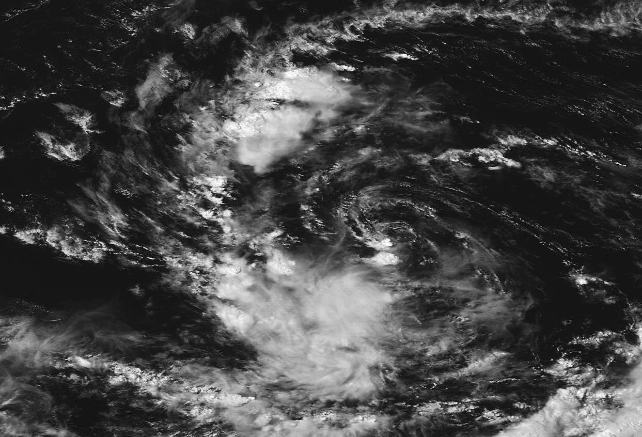
Some deeper convection firing in a band to the NW of the center that has persisted for several hours ... plus some healthy convection and banding to the SE of the center, where 94 looks to be tapping into ITCZ moisture. I wonder if this suggests that the SAL is being mixed out, and if we won't soon have some convection over the center of this one. In my opinion, 94 looks MUCH healthier than TD10 in terms of overall organization, plus we're getting toward the heart of the season. I think it therefore stands a better chance of charting a different course toward real development. We shall see!
http://www.ssd.noaa.gov/goes/east/tatl/flash-rb.html
http://www.ssd.noaa.gov/goes/east/tatl/flash-rb.html
0 likes
-
Blown Away
- S2K Supporter
- Posts: 10253
- Joined: Wed May 26, 2004 6:17 am
Re: ATL: INVEST 94L

All classified systems near 94l's current position!
The farther west 94L goes w/o deepening the more runners strike land! There are some biggies on this map. WOW
Still gotta stay w/ my prediction of 94L going above Hispaniola.
0 likes
Hurricane Eye Experience: David 79, Irene 99, Frances 04, Jeanne 04, Wilma 05… Hurricane Brush Experience: Andrew 92, Erin 95, Floyd 99, Matthew 16, Irma 17, Ian 22, Nicole 22…
-
Hurricane Andrew

- S2K Supporter
- Posts: 1891
- Age: 27
- Joined: Sun May 23, 2010 2:53 pm
- Location: KS
-
otowntiger
- Category 5
- Posts: 1932
- Joined: Tue Aug 31, 2004 7:06 pm
Re: ATL: INVEST 94L
All classified systems near 94l's current position!
The farther west 94L goes w/o deepening the more runners strike land! There are some biggies on this map. WOW
Still gotta stay w/ my prediction of 94L going above Hispaniola.[/quote] Wow! Look at that! It seems that over 90% of all classified storms in this area miss land altogether! Hopefully if (big if) this thing develops it will follow climo and re-curve harmlessly out to sea like so many of its predecessors.
0 likes
-
Blown Away
- S2K Supporter
- Posts: 10253
- Joined: Wed May 26, 2004 6:17 am
Re: ATL: INVEST 94L
Convection burst south of LLC, let's see if this is the beginning?
http://www.ssd.noaa.gov/PS/TROP/floater ... -long.html
http://www.ssd.noaa.gov/PS/TROP/floater ... -long.html
0 likes
Hurricane Eye Experience: David 79, Irene 99, Frances 04, Jeanne 04, Wilma 05… Hurricane Brush Experience: Andrew 92, Erin 95, Floyd 99, Matthew 16, Irma 17, Ian 22, Nicole 22…
-
TreasureIslandFLGal

- S2K Supporter
- Posts: 1584
- Age: 58
- Joined: Sun Aug 15, 2004 6:16 pm
- Location: Cancun, Mexico (northeast Yucatan coast)
Re: Re:
Shuriken wrote:IMO there is not one thing atypical about this year so far. Invest 94 is moving at an average rate of speed for a pre-TD whorl, and King Cap still rules the central Atlantic in mid-August. Read: no 200mb exhausting allowed.TreasureIslandFLGal wrote:Why are storms moving fast this year and having a hard time developing?
Most Invests croak -- fact of life every year.
The fact that there is an LLC despite relatively modest convection indicates that things have come together in the lower atmosphere; all that remains is for a big CB to clear the pipe to 200mb as the system reaches the 29C isotherm sometime later today or tonight. If it happens, I94 should take off exponentially; if it doesn't, it'll sputter and putter and taffy out like TD10.
I was answering someone else. I concur with you that this is nothing different this year at all, as far as years with strong, large ridges in place.
0 likes
Chrissy & Ligeia

-
Mouton
- S2K Supporter
- Posts: 222
- Age: 80
- Joined: Sat Jul 30, 2011 8:13 am
- Location: Amelia Island Florida
Re: ATL: INVEST 94L
BatzVI wrote:So it's staying south...anything to indicate a future northern trek?
To my untrained eye, it looks like there is a developing ULL to the northwest of this system. Also there is a good deal of dry air north of the horizontal axis. Perhaps the developing system will track a tad south of west over the next few days.
After that, it appers the high will be building back across the northern part of Fla over the weekend too which could send this system up the gulf side of the peninsula if it ever develops into a storm.
This is just my unofficial ramblings, devoid of any official imperator.
0 likes
-
Blown Away
- S2K Supporter
- Posts: 10253
- Joined: Wed May 26, 2004 6:17 am
Re: ATL: INVEST 94L
At @150 hours 94L is south of Cuba and feels the weakness and turns N into Florida. IMO, for 94L to make the GOM it needs to go above the big islands and that track will be shorter and will go farther west before feeling the weakness at @150 hours. 
Convection building! http://www.ssd.noaa.gov/PS/TROP/floater ... -long.html
Convection building! http://www.ssd.noaa.gov/PS/TROP/floater ... -long.html
0 likes
Hurricane Eye Experience: David 79, Irene 99, Frances 04, Jeanne 04, Wilma 05… Hurricane Brush Experience: Andrew 92, Erin 95, Floyd 99, Matthew 16, Irma 17, Ian 22, Nicole 22…
-
Weatherboy1
- Category 5
- Posts: 1190
- Age: 50
- Joined: Mon Jul 05, 2004 1:50 pm
- Location: Jupiter/Sarasota, FL
Finally a burst of convection going up over the center in the past hour or so. That is really the ONLY thing standing between designation of this system as an official TD, in my opinion, as we clearly have a large circulation envelope, an LLC, decent banding to the NW and SE, and so on. Should this latest batch of convection persist through the evening, I would not be surprised in the least to see them give it a number at 11 p.m. We'll see if it lasts.
0 likes

Re: Re:
Shuriken wrote:IMO there is not one thing atypical about this year so far. Invest 94 is moving at an average rate of speed for a pre-TD whorl, and King Cap still rules the central Atlantic in mid-August. Read: no 200mb exhausting allowed.TreasureIslandFLGal wrote:Why are storms moving fast this year and having a hard time developing?
Most Invests croak -- fact of life every year.
The fact that there is an LLC despite relatively modest convection indicates that things have come together in the lower atmosphere; all that remains is for a big CB to clear the pipe to 200mb as the system reaches the 29C isotherm sometime later today or tonight. If it happens, I94 should take off exponentially; if it doesn't, it'll sputter and putter and taffy out like TD10.
No but I agree with TreasureI. it 'seems" like they are moving faster than years before. I must have missed the faster 20-25mph moving posts and information....
0 likes
-
cycloneye
- Admin
- Posts: 149214
- Age: 69
- Joined: Thu Oct 10, 2002 10:54 am
- Location: San Juan, Puerto Rico
Re: ATL: INVEST 94L
There is no question that there is a very well defined LLC but convection is not plenty right now.

0 likes
Visit the Caribbean-Central America Weather Thread where you can find at first post web cams,radars
and observations from Caribbean basin members Click Here
and observations from Caribbean basin members Click Here
Who is online
Users browsing this forum: No registered users and 15 guests