ATL: ISAAC - Post-Tropical - Discussion

Moderator: S2k Moderators

Message
Author
User avatar
SouthFloridawx
S2K Supporter
S2K Supporter
Posts: 8346
Age: 46
Joined: Tue Jul 26, 2005 1:16 am
Location: Sarasota, FL
Contact:

Re: ATL: ISAAC - Tropical Storm - Discussion

#1261 Postby SouthFloridawx » Tue Aug 21, 2012 11:48 pm

thetruesms wrote:
Patrick99 wrote:Just to inject a little levity.....how many times has South Florida been squarely in a 5-day cone over the last 10 years? Quite a few, if my memory serves me. How many of those actually turned out to be hits 5 days later? 8-)
So, I know this was posted completely tongue-in-cheek, but I decided to quickly dig through the archived graphics just for funsies. Assuming I kept count correctly, and it's possible I'm off by one or two because my eyes started to cross a little after staring at so many maps, this is now the 44th time any part of Florida - including the Keys - has been within the cone (I just lumped the 3 and 5 day cones together, because it was easier and my inspiration was a joke :P ). 19 of the previous 43 times, the storm center was over Floridian soil. Doesn't sound like a good percentage off the bat. But, it's worth noting that most of these "misses" came from the edge of the 5-day cone nicking some part of Florida because by Day 5, the cone is pretty darn big - meanwhile, the actual forecast track wasn't in Florida's direction at all. Some were closer misses - i.e. a storm that passed through the Florida Straits, giving the Keys hurricane conditions, but never actually made a landfall; or a landfalling storm in Louisiana that headed east, only to have its last advisory given with the storm center in the Alabama Panhandle, about 10 miles west of the Florida border. Surely its remnants passed into Florida.

I suppose if I cared more, I would swing through again and definitively see how many times any of the forecast points were over Florida only to see NHC whiff on their track. But qualitatively, it wasn't very many - in the counting on one hand neighborhood. Ike and Irene were the notable misses, but not much beyond that.

And that, my friends, is what comes out of letting yourself be "inspired" by a facetious comment. I don't really recommend it, but if you want to try, I think I left a couple avenues for further research. :lol:

edit - also, this is only the 9th season with a public five day cone, so I didn't do 2003 to shave off a little effort.


Can I like this post somehow? lol :?:
0 likes   

Shuriken

#1262 Postby Shuriken » Wed Aug 22, 2012 12:22 am

The only thing certain about the center-point of the five day recurve-scenario forecast cone is that that's where the storm won't be in five days.
0 likes   

User avatar
boca
Category 5
Category 5
Posts: 6367
Age: 60
Joined: Mon Dec 15, 2003 8:49 am
Location: Boca Raton,FL

Re: ATL: ISAAC - Tropical Storm - Discussion

#1263 Postby boca » Wed Aug 22, 2012 12:28 am

Im thinking 2 days from now even as early as tomorrow this will be a Bahamas system and not a Florida system the GFS has been shifting east and I think its a trend.
0 likes   

User avatar
Hammy
Category 5
Category 5
Posts: 5849
Age: 42
Joined: Fri May 25, 2012 5:25 pm
Contact:

#1264 Postby Hammy » Wed Aug 22, 2012 12:52 am

from recon looks like a secondary low to the SW, possibly a leftover of the monsoon trough
0 likes   
The above post is not official and should not be used as such. It is the opinion of the poster and may or may not be backed by sound meteorological data. It is not endorsed by any professional institution or storm2k.org. For official information, please refer to the NHC and NWS products.

Shuriken

Re:

#1265 Postby Shuriken » Wed Aug 22, 2012 1:11 am

Hammy wrote:from recon looks like a secondary low to the SW, possibly a leftover of the monsoon trough
How far southwest, and southwest of what point?
0 likes   

chrisjslucia
S2K Supporter
S2K Supporter
Posts: 236
Joined: Thu Oct 09, 2008 8:27 pm
Location: St Lucia

#1266 Postby chrisjslucia » Wed Aug 22, 2012 1:19 am

Latest Meteo France radar image
Image
0 likes   

chrisjslucia
S2K Supporter
S2K Supporter
Posts: 236
Joined: Thu Oct 09, 2008 8:27 pm
Location: St Lucia

#1267 Postby chrisjslucia » Wed Aug 22, 2012 1:21 am

And Barbados Radar

Image
0 likes   

Shuriken

#1268 Postby Shuriken » Wed Aug 22, 2012 1:30 am

That meatball is gettin' spicy.

Tonight's as good as any for a rapid deepening cycle....

Image
0 likes   

pricetag56
Tropical Storm
Tropical Storm
Posts: 133
Joined: Sat Aug 21, 2010 4:18 pm

Re: ATL: ISAAC - Tropical Storm - Discussion

#1269 Postby pricetag56 » Wed Aug 22, 2012 1:50 am

this could change things if it does occur
0 likes   

pricetag56
Tropical Storm
Tropical Storm
Posts: 133
Joined: Sat Aug 21, 2010 4:18 pm

Re:

#1270 Postby pricetag56 » Wed Aug 22, 2012 1:52 am

Shuriken wrote:That meatball is gettin' spicy.

Tonight's as good as any for a rapid deepening cycle....

Image

looks like the instability is increasing as the environment moistens
0 likes   

Shuriken

Re: Re:

#1271 Postby Shuriken » Wed Aug 22, 2012 2:18 am

pricetag56 wrote:looks like the instability is increasing as the environment moistens
Nah -- it's blowing up everywhere: west-side feeder, center, left-side feeder, simultaneously.

That means it's either diurnal or cap-related, or both.
0 likes   

User avatar
Kingarabian
S2K Supporter
S2K Supporter
Posts: 15986
Joined: Sat Aug 08, 2009 3:06 am
Location: Honolulu, Hawaii

#1272 Postby Kingarabian » Wed Aug 22, 2012 2:41 am

So far we have 47kts of FL winds and a pressure of 1006.
0 likes   
RIP Kobe Bryant

User avatar
meriland23
Category 5
Category 5
Posts: 1239
Age: 37
Joined: Mon Aug 29, 2011 9:29 pm

#1273 Postby meriland23 » Wed Aug 22, 2012 2:51 am

I am most concerned about wind speed, seems anywhere from cat 1-3.. is it possible that is could be a 4 or 5?
0 likes   
The posts in this forum are NOT official forecast and should not be used as such. They are just the opinion of the poster and may or may not be backed by sound meteorological data. They are NOT endorsed by any professional institution or storm2k.org. For official information, please refer to the NHC and NWS products.

RL3AO
Moderator-Pro Met
Moderator-Pro Met
Posts: 16308
Joined: Thu Jun 14, 2007 10:03 pm
Location: NC

#1274 Postby RL3AO » Wed Aug 22, 2012 2:56 am

Looks like its not the most organized at the lower levels.
0 likes   

RL3AO
Moderator-Pro Met
Moderator-Pro Met
Posts: 16308
Joined: Thu Jun 14, 2007 10:03 pm
Location: NC

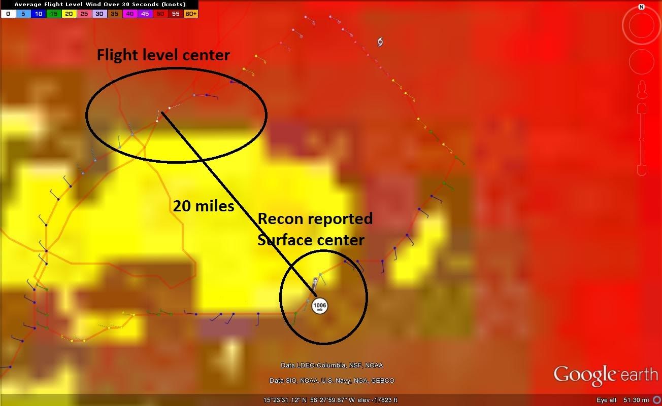
#1275 Postby RL3AO » Wed Aug 22, 2012 3:02 am

Expansion on my latest post.

Image

From VDM - Maximum Flight Level Temp: 21°C (70°F) which was observed 20 nautical miles (23 statute miles) to the N (357°) from the flight level center

This is in really bad shape. Surface center and MLC are 20 miles apart.

Then someone on chat and one of our pro mets pointed this out from the VDM


I. Maximum Flight Level Temp & Pressure Altitude Outside Eye: 20°C (68°F) at a pressure alt. of 1,523m (4,997ft)
J. Maximum Flight Level Temp & Pressure Altitude Inside Eye: 17°C (63°F) at a pressure alt. of 1,527m (5,010ft)

Its warmer outside the center then in the center. There is some serious displacement going on.
0 likes   

Shuriken

#1276 Postby Shuriken » Wed Aug 22, 2012 3:37 am

We've had -80C tops for nearly six hours now.

...I would surmise that a new surface LLC has formed under the convection core, and the suction-draw has taffy-fied the remnants of the old one to the northwest (leaving only the mid-levels for the plane to encounter).
0 likes   

User avatar
Dynamic
Tropical Depression
Tropical Depression
Posts: 81
Joined: Wed Jul 19, 2006 2:11 pm

Re: ATL: ISAAC - Tropical Storm - Discussion

#1277 Postby Dynamic » Wed Aug 22, 2012 3:38 am

Hi, just a quick question. In the water vapor loop bellow, what is that circulation moving from the southwest to the northeast of isaac?

What effect may have on isaac?

Thanks!

http://www.ssd.noaa.gov/goes/east/carb/flash-wv.html
0 likes   

RL3AO
Moderator-Pro Met
Moderator-Pro Met
Posts: 16308
Joined: Thu Jun 14, 2007 10:03 pm
Location: NC

Re: ATL: ISAAC - Tropical Storm - Discussion

#1278 Postby RL3AO » Wed Aug 22, 2012 3:40 am

Dynamic wrote:Hi, just a quick question. In the water vapor loop bellow, what is that circulation moving from the southwest to the northeast of isaac?

What effect may have on isaac?

Thanks!

http://www.ssd.noaa.gov/goes/east/carb/flash-wv.html


Its an upper level low. It shouldn't impact it too much. If anything it would probably help with upper level outflow.
0 likes   

User avatar
Dynamic
Tropical Depression
Tropical Depression
Posts: 81
Joined: Wed Jul 19, 2006 2:11 pm

Re: ATL: ISAAC - Tropical Storm - Discussion

#1279 Postby Dynamic » Wed Aug 22, 2012 3:42 am

RL3AO wrote:
Dynamic wrote:Hi, just a quick question. In the water vapor loop bellow, what is that circulation moving from the southwest to the northeast of isaac?

What effect may have on isaac?

Thanks!

http://www.ssd.noaa.gov/goes/east/carb/flash-wv.html


Its an upper level low. It shouldn't impact it too much. If anything it would probably help with upper level outflow.


Thank You!
0 likes   

JamesCaneTracker
Tropical Storm
Tropical Storm
Posts: 207
Joined: Fri Jun 22, 2012 1:33 pm
Location: Portland, Maine

Re: ATL: ISAAC - Tropical Storm - Discussion

#1280 Postby JamesCaneTracker » Wed Aug 22, 2012 3:44 am

M. Eye Shape & Diameter: Circular with a diameter of 10 nautical miles (12 statute miles)

Small eyewall and a pretty quick pressure drop of 3mb between center fixes!
0 likes   


Return to “2012”

Who is online

Users browsing this forum: No registered users and 2 guests