The NWS in Brownsville had some good information regarding 95L impact on our weather.....I take back what I said Porta! lol
"THROUGH ABOUT 4 TO 10 AM MONDAY EXPECT DRIER LOW LEVEL AIR WILL
BEGIN TO WORK IN AS WINDS SHIFT NORTHEASTWARD. NAM/GFS/ECMWF ALL
SHOW A REASONABLE RESISTANCE TO THE FRONTAL BOUNDARY AS IT
APPROACHES THE SOUTH TEXAS COAST WHILE WAITING FOR AN EXTRA SHOT
FROM A SECONDARY JET MAX. SO WITH THAT...WE POTENTIALLY WOULD HAVE
SOME FORM OF BOUNDARY DRAPED NEAR THE COAST WITH MOIST ONSHORE
FLOW OCCURRING AHEAD OF THE FRONT...SO WILL CARRY A HEALTHY CHANCE
OF RAIN NEAR THE COAST TOMORROW AND EASE THE POPS UP AS YOU HEAD
INLAND. ANOTHER SIZEABLE FLY IN THE OINTMENT IS THE MCV/TROUGH
OVER THE NORTHWESTERN GULF OF MEXICO ABOUT 150 MILES TO THE SOUTH
SOUTHEAST OF BROWNSVILLE. A FLARE UP OF CONVECTION NEAR THIS STORM
DURING THE OVERNIGHT DIURNAL MAXIMUM COULD PLAY A ROLE IN EITHER
PULLING THE WINDS MORE TOWARDS THE NORTH...USHERING IN DRY AIR
FASTER...OR PERHAPS BLOCKING THE FRONTAL PASSAGE FURTHER SOUTH. IT
COULD ALSO SEND OUTFLOW BOUNDARIES NORTHWEST INTO THE AREA HELPING
INITIATE CONVECTION. BASED ON ITS APPEARANCE AT THE MOMENT WILL
ASSUME FOR NOW ITS INFLUENCE WILL BE MINIMAL.
TO SUMMARIZE...LIGHT STRATIFORM RAIN WORKING NORTHWEST TO
SOUTHEAST TONIGHT. DRY AIR PUSHES INTO THE WEST EARLY IN THE
MORNING ON MONDAY BUT PROBABLY WILL NOT MAKE IT ALL THE WAY
THROUGH OUR CWA...WE ARE NOT SURE EXACTLY HOW FAR IT WILL GO...BUT
PLACES LIKE BROWNSVILLE AND PORT ISABEL PROBABLY WILL NOT GET IN
THE DRY AIR INITIALLY. WITH A NICE BOUNDARY FOR CONVERGENCE SET UP ACROSS
THE CWA SHOWERS AND THUNDERSTORMS WILL PROBABLY DEVELOP IN THE
HEATING OF THE DAY...UNTIL THE FINAL PUSH OF THE UPPER TROUGH
NUDGES THE BOUNDARY ALL THE WAY THROUGH LATE TOMORROW AFTERNOON
DRYING OUR AIRMASS FOR THE IMMEDIATE TIME BEING AND LOWERING RAIN
CHANCES. ALL THIS IS ALSO ASSUMING THE COMPLEX TO THE SOUTHEAST DOES
NOT GET TOO CARRIED AWAY IN THE NEXT 24 HOURS. /68-JGG/"
Texas Summer 2012
Moderator: S2k Moderators
Forum rules

The posts in this forum are NOT official forecast and should not be used as such. They are just the opinion of the poster and may or may not be backed by sound meteorological data. They are NOT endorsed by any professional institution or STORM2K.
-
Rgv20

- S2K Supporter

- Posts: 2466
- Age: 39
- Joined: Wed Jan 05, 2011 5:42 pm
- Location: Edinburg/McAllen Tx
0 likes
The following post is NOT an official forecast and should not be used as such. It is just the opinion of the poster and may or may not be backed by sound meteorological data. It is NOT endorsed by any professional institution including storm2k.org For Official Information please refer to the NHC and NWS products.
-
somethingfunny

- ChatStaff

- Posts: 3926
- Age: 37
- Joined: Thu May 31, 2007 10:30 pm
- Location: McKinney, Texas
Re: Texas Summer 2012
I can't wait to see this week's Drought Monitor.

0 likes
I am not a meteorologist, and any posts made by me are not official forecasts or to be interpreted as being intelligent. These posts are just my opinions and are probably silly opinions.
-
weatherdude1108
- Category 5

- Posts: 4228
- Joined: Tue Dec 13, 2011 1:04 pm
- Location: Northwest Austin/Cedar Park, TX
-
Portastorm

- Storm2k Moderator

- Posts: 9955
- Age: 63
- Joined: Fri Jul 11, 2003 9:16 am
- Location: Round Rock, TX
- Contact:
Re:
weatherdude1108 wrote:Looks eery outside this morning at around 6:30 am. Fast moving dark clouds and windy. Feels nice. I think an outflow boundary just moved through. A couple sprinkles.
It did ... an outflow boundary from the MCS just to our north. Could provide enough instability later this afternoon for some widely scattered showers/storms. Let's hope so!
0 likes
Any forecasts under my name are to be taken with a grain of salt. Get your best forecasts from the National Weather Service and National Hurricane Center.
-
weatherdude1108
- Category 5
- Posts: 4228
- Joined: Tue Dec 13, 2011 1:04 pm
- Location: Northwest Austin/Cedar Park, TX
Re: Re:
Portastorm wrote:weatherdude1108 wrote:Looks eery outside this morning at around 6:30 am. Fast moving dark clouds and windy. Feels nice. I think an outflow boundary just moved through. A couple sprinkles.
It did ... an outflow boundary from the MCS just to our north. Could provide enough instability later this afternoon for some widely scattered showers/storms. Let's hope so!
Yes! Bring it!


0 likes

Re: Texas Summer 2012
Wow, it's really nice outside been around 70 at DFW all morning and likely won't rise much higher with the steady light rain. 65-75 around the metro. Average is 96/75 
102 for a high 84 for a low last year, 104 and 82 in 2010. Is this August or October?!
102 for a high 84 for a low last year, 104 and 82 in 2010. Is this August or October?!
0 likes
The above post and any post by Ntxw is NOT an official forecast and should not be used as such. It is just the opinion of the poster and may or may not be backed by sound meteorological data. It is NOT endorsed by any professional institution including Storm2k. For official information, please refer to NWS products.
Help support Storm2K!
-
Rgv20
- S2K Supporter
- Posts: 2466
- Age: 39
- Joined: Wed Jan 05, 2011 5:42 pm
- Location: Edinburg/McAllen Tx
0 likes
The following post is NOT an official forecast and should not be used as such. It is just the opinion of the poster and may or may not be backed by sound meteorological data. It is NOT endorsed by any professional institution including storm2k.org For Official Information please refer to the NHC and NWS products.
-
Rgv20
- S2K Supporter
- Posts: 2466
- Age: 39
- Joined: Wed Jan 05, 2011 5:42 pm
- Location: Edinburg/McAllen Tx
Got 0.26 of Rain in my backyard this afternoon....every little thing helps!
0 likes
The following post is NOT an official forecast and should not be used as such. It is just the opinion of the poster and may or may not be backed by sound meteorological data. It is NOT endorsed by any professional institution including storm2k.org For Official Information please refer to the NHC and NWS products.
-
weatherdude1108
- Category 5
- Posts: 4228
- Joined: Tue Dec 13, 2011 1:04 pm
- Location: Northwest Austin/Cedar Park, TX
I'm guessing Isaac is going to be another DUD in a streak of tropical storm DUDS for Texas? We'll get the "hot and dry" part of it, as usual (memories of last September 2011), with moisture being sucked out of the Gulf into Isaac to east. 

C'mon El Nino! You're our last hope! Hmmm.
Gotta go dream of singing in the rain.
C'mon El Nino! You're our last hope! Hmmm.
Gotta go dream of singing in the rain.
0 likes
-
Portastorm
- Storm2k Moderator
- Posts: 9955
- Age: 63
- Joined: Fri Jul 11, 2003 9:16 am
- Location: Round Rock, TX
- Contact:
Re: Texas Summer 2012
If Isaac follows the currently forecasted path and achieves some of the potential of being a strong hurricane, I think we could see a pattern change with cooler, drier air coming south into the Southern Plains and Texas by next week. If Isaac pulls a "fast one" and moves further west than anticipated ... yeah, you can plan on hot and dry.
How many times have we seen that happen with a hurricane plowing north into the central Gulf coast.
How many times have we seen that happen with a hurricane plowing north into the central Gulf coast.
0 likes
Any forecasts under my name are to be taken with a grain of salt. Get your best forecasts from the National Weather Service and National Hurricane Center.
Well, I'm not seeing anything out of the ordinary. Seasonal warmth with bouts of scattered rain chances more typical of August. If a ridge does form stronger to our north maybe it can pull whatever is of Isaac remnants closer back to Texas after landfall. Some models point to a hot end to August but I'm having my doubts with that since the PNA will not be favoring that outcome.
Little side note ENSO has cooled quite a bit this week at 3.4. I'm not sure if that's a short term trend or long term but on the upside the MJO is not in the favorable position right now so that may just be it and nothing extraordinary.
Little side note ENSO has cooled quite a bit this week at 3.4. I'm not sure if that's a short term trend or long term but on the upside the MJO is not in the favorable position right now so that may just be it and nothing extraordinary.
0 likes
The above post and any post by Ntxw is NOT an official forecast and should not be used as such. It is just the opinion of the poster and may or may not be backed by sound meteorological data. It is NOT endorsed by any professional institution including Storm2k. For official information, please refer to NWS products.
Help support Storm2K!
Help support Storm2K!
-
somethingfunny
- ChatStaff
- Posts: 3926
- Age: 37
- Joined: Thu May 31, 2007 10:30 pm
- Location: McKinney, Texas


-
Rgv20
- S2K Supporter
- Posts: 2466
- Age: 39
- Joined: Wed Jan 05, 2011 5:42 pm
- Location: Edinburg/McAllen Tx
Houston NWS afternoon discussion regarding Isaac....Going to be interesting to see if the computer models keep trending west.
YESTERDAY THE QUESTION MARK OVER THE EXTENDED FORECAST FOR NEXT
WEEK WAS SHRINKING. THAT QUESTION MARK GOT A LOT BIGGER AS THE GFS
AND ECMWF 12Z RUNS ARE QUITE DIFFERENT. BOTH MODELS HAVE A MORE
WESTWARD SHIFT IN THE TRACK OF ISAAC. THE GFS MAINTAINS MODEL
TRACK CONSENSUS WHERE THE ECMWF HAS ISAAC IMPACTING PORTIONS OF
SE TX NEXT WED/THUR/FRI. GRANTED THIS IS THE FAR OUTER REACHES OF
THE FORECAST BUT STILL NEED TO KEEP AN EYE ON THE MODEL TRENDS
THROUGH THE WEEKEND. AS FOR NOW THE FORECAST WILL KEEP 20 POPS IN
THE FORECAST AND LEAN MORE ON THE GFS SINCE THE ECMWF IS STILL A
DEPARTURE YET ONE THAT NEEDS TO BE MONITORED.
0 likes
The following post is NOT an official forecast and should not be used as such. It is just the opinion of the poster and may or may not be backed by sound meteorological data. It is NOT endorsed by any professional institution including storm2k.org For Official Information please refer to the NHC and NWS products.
Rgv20 have you seen the ensembles lately? Regardless of where he landfalls there's growing hints that he will be influenced likely by ridging which would send him/remnants west into Texas underneath it one way or the other. Will be interesting to see how it plays out.
0 likes
The above post and any post by Ntxw is NOT an official forecast and should not be used as such. It is just the opinion of the poster and may or may not be backed by sound meteorological data. It is NOT endorsed by any professional institution including Storm2k. For official information, please refer to NWS products.
Help support Storm2K!
Help support Storm2K!
-
Portastorm
- Storm2k Moderator
- Posts: 9955
- Age: 63
- Joined: Fri Jul 11, 2003 9:16 am
- Location: Round Rock, TX
- Contact:
Re:
Ntxw wrote:Rgv20 have you seen the ensembles lately? Regardless of where he landfalls there's growing hints that he will be influenced likely by ridging which would send him/remnants west into Texas underneath it one way or the other. Will be interesting to see how it plays out.
So glad you brought this up. I saw that. A lot of long days/nights ahead for us, I'm thinking.
0 likes
Any forecasts under my name are to be taken with a grain of salt. Get your best forecasts from the National Weather Service and National Hurricane Center.
-
Rgv20
- S2K Supporter
- Posts: 2466
- Age: 39
- Joined: Wed Jan 05, 2011 5:42 pm
- Location: Edinburg/McAllen Tx
Re:
Ntxw wrote:Rgv20 have you seen the ensembles lately? Regardless of where he landfalls there's growing hints that he will be influenced likely by ridging which would send him/remnants west into Texas underneath it one way or the other. Will be interesting to see how it plays out.
Yes just a little while ago, this could get interesting especially for the upper Texas coast. Still a looonnng way out tho.
0 likes
The following post is NOT an official forecast and should not be used as such. It is just the opinion of the poster and may or may not be backed by sound meteorological data. It is NOT endorsed by any professional institution including storm2k.org For Official Information please refer to the NHC and NWS products.
18z GFS is following the suit of Euro in missing the connection. I think the GFS will likely follow it's own ensembles and euro's tonight. After landfall (doesn't matter where) this sucker is eyeing us guys!
0 likes
The above post and any post by Ntxw is NOT an official forecast and should not be used as such. It is just the opinion of the poster and may or may not be backed by sound meteorological data. It is NOT endorsed by any professional institution including Storm2k. For official information, please refer to NWS products.
Help support Storm2K!
Help support Storm2K!
-
Rgv20
- S2K Supporter
- Posts: 2466
- Age: 39
- Joined: Wed Jan 05, 2011 5:42 pm
- Location: Edinburg/McAllen Tx
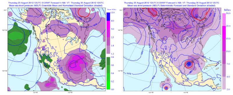
12zECMWF Ensembles by Day 7 look really interesting regarding Isaac for the Upper Texas Coast and LA.....Hopefully with the additional data from the NOAA G-IV tonight's 0zGFS & ECMWF can come until better agreement with the Long Range forecast for Isaac.
0 likes
The following post is NOT an official forecast and should not be used as such. It is just the opinion of the poster and may or may not be backed by sound meteorological data. It is NOT endorsed by any professional institution including storm2k.org For Official Information please refer to the NHC and NWS products.
-
Rgv20
- S2K Supporter
- Posts: 2466
- Age: 39
- Joined: Wed Jan 05, 2011 5:42 pm
- Location: Edinburg/McAllen Tx
Some good Rain just north of my area.....Ranchers are going to be very happy!
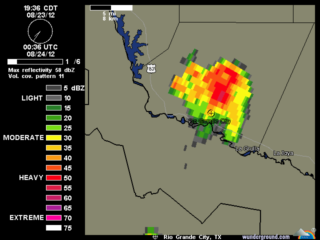
FLOOD ADVISORY
NATIONAL WEATHER SERVICE BROWNSVILLE TX
759 PM CDT THU AUG 23 2012
TXC427-240200-
/O.NEW.KBRO.FA.Y.0074.120824T0059Z-120824T0200Z/
/00000.0.ER.000000T0000Z.000000T0000Z.000000T0000Z.OO/
STARR-
759 PM CDT THU AUG 23 2012
THE NATIONAL WEATHER SERVICE IN BROWNSVILLE HAS ISSUED AN
* ARROYO AND SMALL STREAM FLOOD ADVISORY FOR RAPID ARROYO RISES IN...
CENTRAL STARR COUNTY IN DEEP SOUTH TEXAS.
THIS INCLUDES THE CITY OF EL SAUZ
* UNTIL 900 PM CDT
* AT 758 PM CDT...NATIONAL WEATHER SERVICE METEOROLOGISTS INDICATED
RAINFALL RATES OF TWO INCHES PER HOUR FROM SLOW MOVING SHOWERS AND
THUNDERSTORMS OVER THE ADVISED AREA.
PRECAUTIONARY/PREPAREDNESS ACTIONS...
RAPID RISING STREAMS OR ARROYOS WILL EXCEED THEIR BANKS BY UP TO 1
FOOT. THIS WILL CAUSE MINOR FLOODING OF NEARBY LOW LYING AREAS. MOVE
TO HIGHER GROUND.
DON`T BECOME A STATISTIC. TURN AROUND...DON`T DROWN!
&&
LAT...LON 2669 9892 2669 9863 2641 9863 2641 9891
$$
0 likes
The following post is NOT an official forecast and should not be used as such. It is just the opinion of the poster and may or may not be backed by sound meteorological data. It is NOT endorsed by any professional institution including storm2k.org For Official Information please refer to the NHC and NWS products.
-
weatherdude1108
- Category 5
- Posts: 4228
- Joined: Tue Dec 13, 2011 1:04 pm
- Location: Northwest Austin/Cedar Park, TX
Re: Re:
Portastorm wrote:Ntxw wrote:Rgv20 have you seen the ensembles lately? Regardless of where he landfalls there's growing hints that he will be influenced likely by ridging which would send him/remnants west into Texas underneath it one way or the other. Will be interesting to see how it plays out.
So glad you brought this up. I saw that. A lot of long days/nights ahead for us, I'm thinking.
One model in the ensemble suite of models from Weather Underground (couldn't paste it in here) earlier today had Isaac coming over southeast Texas, then heading straight up towards Austin.
Interesting! Nothing showed that this morning. Will be interesting to see what he does.
0 likes
The preceding post is NOT an official forecast, and should not be used as such. It is only the opinion of the poster and may or may not be backed by sound meteorological data. It is NOT endorsed by any professional institution including storm2k.org. For Official Information please refer to the NHC and NWS products.
Return to “USA & Caribbean Weather”
Who is online
Users browsing this forum: wxman22 and 152 guests