

[quote="Texashawk"]Ominous signs all around for SE TEX - who would have thought 2 days ago? I know I gave up... As did most of the local Houston promets and on-air mets.[/quote
I was about to pull the plug yesterday until the 18z..but the ensembles, the stalling kept my interest...
ATL: ISAAC - Models
Moderator: S2k Moderators
-
Jevo

- S2K Supporter

- Posts: 1729
- Age: 47
- Joined: Tue Aug 03, 2004 8:45 pm
- Location: The Flemish Cap
- Contact:
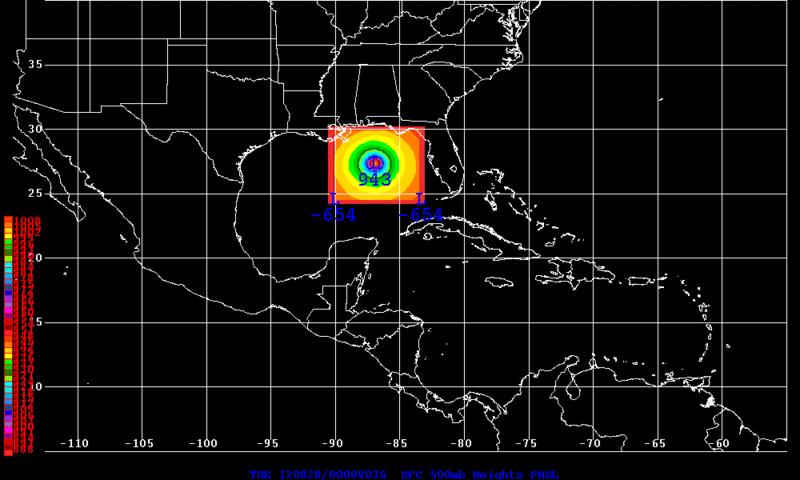
12z HWRF +36

0 likes
Disclaimer: 50% of the time I have no clue of what I am talking about. Chances are I am taking a less than educated guess that sounds good because 10 years ago I stole Mike Watkins book 'The Hurricane and its Impact'. For official information please direct yourself to the NHC and their cadre of weather geniuses.
-
Rgv20

- S2K Supporter
- Posts: 2466
- Age: 39
- Joined: Wed Jan 05, 2011 5:42 pm
- Location: Edinburg/McAllen Tx
12zHWRF +36hrs
0 likes
The following post is NOT an official forecast and should not be used as such. It is just the opinion of the poster and may or may not be backed by sound meteorological data. It is NOT endorsed by any professional institution including storm2k.org For Official Information please refer to the NHC and NWS products.
-
Dean4Storms
- S2K Supporter
- Posts: 6358
- Age: 63
- Joined: Sun Aug 31, 2003 1:01 pm
- Location: Miramar Bch. FL
-
nashrobertsx
- Tropical Depression

- Posts: 85
- Joined: Fri Aug 15, 2008 3:55 pm
-
deltadog03

- Professional-Met

- Posts: 3580
- Joined: Tue Jul 05, 2005 6:16 pm
- Location: Macon, GA
-
Stormlover2012
- Category 1

- Posts: 262
- Joined: Sat Jun 23, 2012 11:03 am


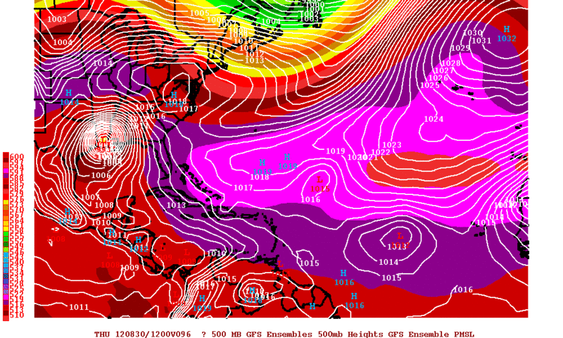
12z GFS ensembles continues support for the OP through 60 hours.

0 likes
The above post and any post by Ntxw is NOT an official forecast and should not be used as such. It is just the opinion of the poster and may or may not be backed by sound meteorological data. It is NOT endorsed by any professional institution including Storm2k. For official information, please refer to NWS products.
Help support Storm2K!


Re:
Dean4Storms wrote:Euro Ensembles were dead on the OP........
http://raleighwx.americanwx.com/models/ ... SLP096.gif
Not exactly true as you don't look at the final point of
Landfall with the ensembles..,you see the increased deviation of the isobars?
0 likes
-
Jevo
- S2K Supporter
- Posts: 1729
- Age: 47
- Joined: Tue Aug 03, 2004 8:45 pm
- Location: The Flemish Cap
- Contact:
Re: ATL: ISAAC - Models
12z HWRF +48

0 likes
Disclaimer: 50% of the time I have no clue of what I am talking about. Chances are I am taking a less than educated guess that sounds good because 10 years ago I stole Mike Watkins book 'The Hurricane and its Impact'. For official information please direct yourself to the NHC and their cadre of weather geniuses.
-
Rgv20
- S2K Supporter
- Posts: 2466
- Age: 39
- Joined: Wed Jan 05, 2011 5:42 pm
- Location: Edinburg/McAllen Tx
12zGFS Ensemble Means are a tad NE than the OP thru 96hrs..
0 likes
The following post is NOT an official forecast and should not be used as such. It is just the opinion of the poster and may or may not be backed by sound meteorological data. It is NOT endorsed by any professional institution including storm2k.org For Official Information please refer to the NHC and NWS products.
-
~FlipFlopGirl~

- Tropical Depression
- Posts: 52
- Age: 47
- Joined: Sat Jul 24, 2010 7:43 pm
- Location: Waco,TX
Re: ATL: ISAAC - Models
I am seeing more and more disagree with the GFS track and having it going into SE Texas as a Cat 3 possibly? Regardless oil production will slow and it's better to gas up regardless which state you are in on the gulf- This is an amazing change - Being in TX we were told at our staff meeting rest assured TX landfall not likely- Low wind shear and nice warm temps in the gulf = perfect storm 
0 likes
-
Jevo
- S2K Supporter
- Posts: 1729
- Age: 47
- Joined: Tue Aug 03, 2004 8:45 pm
- Location: The Flemish Cap
- Contact:
Re: ATL: ISAAC - Models
12z HWRF +54

0 likes
Disclaimer: 50% of the time I have no clue of what I am talking about. Chances are I am taking a less than educated guess that sounds good because 10 years ago I stole Mike Watkins book 'The Hurricane and its Impact'. For official information please direct yourself to the NHC and their cadre of weather geniuses.
-
Dean4Storms
- S2K Supporter
- Posts: 6358
- Age: 63
- Joined: Sun Aug 31, 2003 1:01 pm
- Location: Miramar Bch. FL
Re: ATL: ISAAC - Models
[quote="Jevo"]12z HWRF +48
Good Lord, 930mb headed for New Orleans area!
Good Lord, 930mb headed for New Orleans area!
0 likes

-
Nikki

- S2K Supporter
- Posts: 291
- Joined: Mon Jun 21, 2010 3:38 pm
- Location: Santa Fe, TX (yes I typed that right TEXAS not New Mexico, I am about 20 miles from Galveston, TX)
Re:
HurryKane wrote:Does the next Euro come out at 2 EDT or CDT? Thanks.
2 EDT
0 likes
My name is Nicole and this is what I go by in Storm2k chat! Come chat with us! We have fun in there too!!
A teacher's purpose is not to create students in her own image, but to develop students who can create their own image. ~Author Unknown
Alicia, Allison, Rita, Ike
A teacher's purpose is not to create students in her own image, but to develop students who can create their own image. ~Author Unknown
Alicia, Allison, Rita, Ike
-
Jevo
- S2K Supporter
- Posts: 1729
- Age: 47
- Joined: Tue Aug 03, 2004 8:45 pm
- Location: The Flemish Cap
- Contact:
12z HWRF +60

0 likes
Disclaimer: 50% of the time I have no clue of what I am talking about. Chances are I am taking a less than educated guess that sounds good because 10 years ago I stole Mike Watkins book 'The Hurricane and its Impact'. For official information please direct yourself to the NHC and their cadre of weather geniuses.
Who is online
Users browsing this forum: No registered users and 47 guests